The Road goes ever on and on; Down from the door where it began;
Now far ahead the Road has gone; And I must follow, if I can;
Pursuing it with eager feet; Until it joins some larger way;
Where many paths and errands met; And whither then? I cannot say.

[JRR Tolkien, Lord of the Rings]

Thursday 30 June 2016

Burton Hill and Hegdon Hill

Thursday 30 June

Burton Hill (SO395488; 294m)

image

When Mick sent me his customary ‘Good Morning’ text at five to six this morning he was audibly surprised, when I phoned him straight back, to realise (from my huffing and puffing) that I was already on my way up my first hill. And I’d had a half-hour drive to get there too.

Why the masochistically early start this time? Well, the parking area I’d identified looked perfectly big enough for a car, but a bit tight for Colin, so I figured that if I was going to partially obstruct a gateway, I’d best do it very early in the morning when I could almost guarantee that no-one would want access.

20160630_062830

Actually, I was barely across the gateway at all.

Through the gateway where I’d parked were a couple of permissive paths…

20160630_062925

…but I’m not sure they weren’t confined to the area of the field, as at the top boundary I found a double-strand, permanent electric fence. With Mick still on the phone I took off my pack and commando-rolled under it. He also got a commentary as I got stung by a nettle as I found my way through the hedgerow beyond, which landed me on a public right of way which would lead me to the top. At that point, Mick rang off to go and prepare himself for his final day at work, and I made my way up a very slippery path.

With the top of this hill being relatively flat, and with any slight raises hidden by the whole area being thoroughly covered in brambles, I can’t say for certain that I stood on the highest ground. However, I did have a good tramp around (stopping every now and then to remove thorns from the knees of my trousers) before climbing up onto the fallen branch that you can see in this next snap…

20160630_061603

…which was clearly higher than any of the ground. Thus calling the job a goodun, down I went. It was a short outing, at just 1.3 miles with 500’ of ascent.

Hegdon Hill (SO585539; 255m)

image

It’s possible to drive to within a minute’s walk of the top of Hegdon Hill, but I’d planned a 3.5 mile circular walk from Pencombe, using the Three Rivers Ride long distance route for my outward leg, with a lane walk for my return. Then I got to Pencombe and, over breakfast and a cup of tea, decided that I couldn’t face wading through yet more wet greenery. I still walked, I just opted for tarmac in both directions.

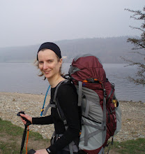
What I hadn’t considered, in my wet-greenery-avoidance decision, was that the summit of this hill sits on the inside boundary of a crop field, meaning that I didn’t escape wading through the wet, long grass of the field margin. In fact, by the time I took the selfie below, my shoes were full of water and my trousers were sodden to mid-thigh:

20160630_083046

Fortunately, the trig point (visible mid-shot) isn’t the highest point of this hill, so there was no issue of crop-trampling. The summit is right on the fence-line, just where I’m standing. 

Getting back to Pencombe (2.9 miles, 300’), I was so amused by the parking situation, with Colin completely blocked in (it was school drop-off time), that I took this photo:

20160630_085509

A minute later, as I was unlacing my shoes, a woman appeared and started questioning me as to why I was taking photographs. I assumed that she thought I was going to complain about the parking, but no, she thought I might have caught a child in my snap. I insisted on showing her the photo to prove that not a single child was included and she went away happy (with the comment that I wouldn’t be going anywhere for a while; good job it wasn’t my intention to move straight away, as it was a while before my exit was cleared*). I went away a little sadder about what a suspicious (and would I be wrong to say overprotective?) world we live in.

And that was that - the end of this little trip. Next it’s back to the Pyrenees for us, picking up the GR10 from where we left it last July.

(*It would have been perfectly possible for those people blocking me in to have parked without obstructing anyone, but they would have had to walk, oooh, maybe 50 yards further.)

Carneddau (Powys), Aberedw Hill and The Begwns

Wednesday 29 June

On Tuesday afternoon I settled Colin into the far corner of the main (riverside) car park in Builth Wells*, fully expecting to have the place to myself for most of the night, and hoping that I wouldn’t be plagued by boy-racers or other antisocial behaviour.

By 8pm I felt like I’d accidentally parked in a truck-stop. Late on, I even moved Colin across a touch, to allow one final artic to squeeze in next to me. The plus side of the company was that I felt very safe and secure (what boy races or antisocial youths are going to hang around a car park full of burly truckers trying to sleep?). On the downside, I suspected my neighbours might be early (and noisy) risers.

Carneddau (SO070552; 445m)

I managed to sleep through a few of the lorries moving, but at 5.25 the one next to me started up and that was me awake. The absence of the sound of rain had me springing out of bed in an instant. Was there a chance, that by acting fast, I could get up my first hill before it rained?

Gone was my plan of a longer-than-necessary walk over the high ground in this area in order to get to this hill. Instead, I’d identified a layby on the A481 which would allow me a much more direction assault:

image

Alas, I didn’t outrun the rain. It started not long before I reached the top, but at least the cloud base was high enough for me to see my surroudings, and from those views I rued the fact that I’d hit this range on such a poor weather day. Maybe we’ll return to Builth Wells sometime for a more significant investigation of the area.

20160629_070814

It wasn’t as misty as it looks in this shot. The photo was taken through my phone case.

Shouts on my return alerted me to the presence of two farmers on quadbikes who were just setting about rounding up the sheep off the hillside. I bet they didn’t expect to see someone striding across that hill, given that it was only 7am! After a bit of a pause to decide whether I was going to cause an impediment, I scurried onwards and don’t think that I got in the way.

By the time I got back to Colin (after 3.3 miles with 1000’) it was looking like my comment yesterday, about needing to walk at 5am then wait till 5pm, if I was going to avoid the rain, was the best plan, so I relocated to my layby for the next hill and set about waiting, waiting and waiting some more, whilst rain variously pitter-pattered or drummed on the tin above my head and the nearby trees went from gently rippling to seriously swaying.

Aberedw Hill (SO 084508; 451m) 

After seven hours of waiting, I was getting itchy feet, so when, at around 3pm, there was a brightening of the sky, I hoped that it signalled the end of the weather front and got myself waterproofed up, ready to go.

This snap doesn’t really do justice to the pretty purpleness of this lane, which led me to the foot of my hill, with fox gloves and thistles in bloom. Nor can you see how slippery the wet stones of the track were.

20160629_151743

Beyond that lane (just as the only shower of the outing hit me) I could clearly see the track switching-back up the steep hillside ahead of me, in a way which gave easy passage up to the more gentle gradients above:

image

Once up there my immediate impression was what a good place this would be for an overnight on a backpacking trip. The difficulty would be choosing on which of the flat, cropped grassy areas to pitch. Next to one of the pools, perhaps?

20160629_154930

I’d love to know how this bit of machinery came to be left up here. Was it an intentional abandonment, or a case of not quite getting around to retrieving it?

By the time I got to the bright-white trig point, the sun was out over Builth Wells…

20160629_160045

… although it was still cloudy in the other direction. I wondered whether the small pools in this next snap are usually there or whether they only appear on particularly wet days, like today:

20160629_160234

It was no hardship to retrace my steps through such loveliness and I arrived back at Colin with 4.7 miles walked with 1100’ of ascent.

The Begwns (SO155444; 415m)

image

By the time I’d eaten an early tea and driven down to The Begwns, it was 6pm, which had made it tempting to cut this walk very short by parking on the little lane just to the east of the hill. The thought of parking Colin on grass after so much rain put me off that option, so I stuck to plan and walked from the good parking area on the next road across.

Wide pathways run all over the place through the bracken which covers the gently rising and falling terrain, only some of which tracks are shown on the map, but it didn’t prove too tricky to just keep heading in generally the right direction.

20160629_180328

The Black Mountain Ridge, of which we walked the length in April, was the notable feature to the SE.

As I crossed the road just before my objective I saw that the ground was perfectly firm enough to have parked there without a problem, but by then the point was academic, so onwards I went to ‘The Roundabout’ atop this hill – a circular stone-walled enclosure, planted inside with trees.

The stated ‘Summit Feature’ for this hill is “highest point in trees of roundabout”, which I thought a bit of a pointless description. Of course the summit is the highest point! This is where I settled on as being the top, although I did, of course, have a good tramp around elsewhere, just to be sure:

20160629_182950

My return leg (which was as wet as my outward one; there were lots of fast-moving showers around) varied slightly from my outward leg only because one path through bracken looks very like another and I failed to pick the same options on the way back.

This one came in at 3.6 miles with 400’ of ascent and rounded off a day which, considering the weather, was surprisingly good, with three enjoyable hills walked and a book and a half read.

(*Powys County Council has an unusually motorhome friendly policy and allows both motorhomes and caravans to stay in its Pay & Display car parks for one night in seven)

Tuesday 28 June 2016

Bradnor Hill, Great Rhos and Gwaunceste Hill

What a contrast to yesterday! I had a lovely time on three hills this morning, without a single sting or prickle incurredSmile

Bradnor Hill (SO282584; 391m)

image

(Post blog note: 12 October 2016 – After this trip I bought 1:25k mapping for the whole of the UK and have just noticed that the relevant land around Bradnor Hill is designated as Access Land. Thus all of my reference to trespass in this post are incorrect. I had every right to be there!)

This hill was originally scheduled into our Offa’s Dyke jaunt in April, but got omitted due to the blatant trespass across a golf course at a busy time of day. It was far from busy this morning, which I attribute to the fact that I set out at 6am.

Consideration had been given to driving up to the Club House, but when I weighed the time it would take to relocate myself there, versus the time it would take to just walk from Kington town car park, I opted for the longer walk, revisiting a part of Offa’s Dyke Path which was still fresh in my mind.

Only one person was met on the entire outing, and that was a groundsman/greenkeeper. He was a friendly chap and didn’t bat an eyelid at my plans to walk across the golf course. A golf course, incidentally, which was covered in sheep and in sheep-poo at the moment. Either the course isn’t open, or surely sheep must regularly get hit, not to mention the likelihood of the golfballs rolling in poo.

Having taken a photo of myself beaming at the top…

20160628_063921

…I opted for a different descent route. Well, if I was going to trespass across a golf course, I thought I may as well make a thorough job of it and cover as much ground as possible!

I’d covered 3.4 miles with 800’ of ascent when I got back to Colin at a couple of minutes past seven, and I didn’t even pause for tea or second breakfast before I made haste towards my next hill. Why the rush? Rain was forecast at noon and I didn’t want to get wet!

Great Rhos (SO182639; 660m)

image

My intention had been to start this one from a car park next to the school in New Radnor, but when I got there the whim took me to go and look at the Water-Break-Its-Neck car park a couple of miles up the road. I probably would have abandoned Colin in the picnic area I’d spotted on my on-line explorations of this area, if it hadn’t been for a sign indicating that there was another car park a kilometre up the track. Onwards I went, almost losing my nerve as I wondered if I’d misunderstood the sign and whether it was telling me that the car park was by the road, and the waterfall was a kilometre further on. By then though I was already committed to a lengthy reverse, so thought I may as well plough on in the hope of finding a Colin-sized turning area if nothing else. What I found was a car park a kilometre further on. Excellent! That cut an out-and-back walk up a dull track from my outing.

The going on this one was varied indeed, featuring forest paths, forest tracks, mown bits of forest…

20160628_081554

…a hill track so long abandoned that it is now but a vague suggestion of a trod on the ground, and a couple of hundred metres or so of very rough yomping. On arriving at the trig I found that the latter had been unnecessary; I took the good path on the way back!

Two possible circuits had been plotted for this outing, one taking in just this hill, the other taking in a series of tops. In the event, I did neither, but retraced my steps instead. For the eagle-eyed, who pay great attention to my selfies, the clue as to why is in the next photo:

20160628_090417

Yikes! Where are my sunglasses? Presumably somewhere in the forest where I’d dropped them whilst adjusting my layers. Retracing my steps seemed the most likely way of recovering them, so that’s what I did, trying hard to concentrate on looking at the ground.

So hard did I look that I noticed this skeleton, which I’d missed on my outward leg. Is it a dog?

20160628_094014

A few minutes before getting back to Colin, it seemed rude to pass by the turn for Water-Break-Its-Neck without going for a look. Worth the short detour, I thought:

20160628_095632

I arrived back at Colin with 6.4 miles walked with around 1600’ of ascent. And the sunglasses, I hear you ask, were they found? Yep – sitting on Colin’s sofa…

Gwaunceste Hill (SO158555; 542m)

image

I came up with two plans for this trip, imaginatively called Plan A and Plan B. Plan A was the conservative Plan. Plan B was more ambitious and included more hills. Having finished today’s Plan A hills before 10am, and with no sign of approaching rain, it was a no-brainer to skip to Plan B, which saw me heading over to Gwaunceste Hill.

Many people start this walk from just before the farm at Rhewey, and many others start from the layby on the main road at the bottom of Rhewey’s access road. Those options give shorter walks, but they also involve passing through a farm with reports of vocal, although tethered, dogs. Tethered dogs are better than untethered, but I still prefer to avoid walking through farms where there’s an obvious alternative, so I opted for a slightly longer walk in from Llynheilyn.

Good decision! What a lovely walk that was on some gorgeous grassy hill tracks. Even the final yomp through deep heather, when I realised that the ‘path’ I was on was so poor that it would be easier to go straight up than to continue onwards to the track which would (theorectically) take me more easily to the top.

20160628_113241

The skies were starting to look ominous by the time I took my summit photos, so pausing only to text Mick to tell him of my whereabouts, down I headed.

The rain had been forecast to arrive at noon. At 1209 the first drops were felt. At 1212 I arrived back at Colin. Twenty minutes later it was lashing down. I’m so glad I wasn’t out in that! Alas, I watched the BBC forecast this lunchtime which has confirmed that there will be no avoiding getting wet tomorrow – unless I set out at 5am or after 5pm.

This final hill of the day came in at 4.4 miles with 700’ of ascent.

Monday 27 June 2016

Wapley Hill and Shobdon Hill

image

Unless my memory is selective and is doing that ‘it was always sunny when I was young’ thing, I think it would be true to say that I enjoy well over 99% of my walks. Probably over 99.9% in fact. Today’s walk fell into the very tiny minority. In fact, it fell so far down the scale of enjoyment, that there isn’t even a glimmer of it transforing into a ‘good walk in hindsight’ (you know, like those outings where something happens that’s really trying at the time, but looking back on it it becomes either fun or funny).

It wasn’t entirely bad as an outing. The first bit, from the Wapley Hill Forestry Commission car park, whilst a bit muddy in places, was perfectly pleasant and very straightforward as I simply followed the red way-markers uphill. The evidence of the hill fort atop my objective was the undisputed highlight of the day, with more banks and dips than I ever recall seeing at a hill fort before. I even easily located the correct ‘oak tree on a mound’, which is the summit feature of this top.

20160627_135756

Oak tree on a mound, otherwise known as the Marilyn summit

There were snippets of views to be had in a few directions too:

20160627_135841

It was in between Wapley Hill and Shobdon Hill that the wheels started falling off my day. It all started with me missing my path and merrily skipping onwards, almost back to the car park, before I noticed. I could have just continued back down and walked along the road (in hindsight, that would have been a good plan) or even driven to my next objective (in hindsight, that would have been a *really* good plan), but the Mortimer Trail, which follows a byway along the ridge, looked pleasant on the map so I went back uphill to find it. No wonder I missed it on my first pass:

20160627_142435

For the next mile, I battled through overgrown 6’ bracken, intertwined with spikey, grabby and stingy things. Seldom have I been so pleased to reach tarmac as I was when the awfulness of it came to an end (also, seldom have I been so pleased, on such a warm day, to have chosen to wear trousers. They’re not nettle-proof, but they’re more so than bare legs).

At the village of Byton, finding no evidence of the footpath I wanted (which would have lopped off a bit of road walking), I stuck with the Mortimer Trail and went the slightly longer way around, taking an extra detour for a quick look at the pretty little church, the name of which I have already forgotten:

20160627_150236

After another short backtrack for another missed turn, the bracken/brambles/nettles nightmare started all over again. Wet bracken too, even though it was a nice day. I would have been pleased to get to the top, if it hadn’t been for the knowledge that the only sensible way back was to repeat the last mile of overgrowth.

I’m pretty sure that the place where I’m standing in the next snap is the top, although ‘ground by oak tree’ isn’t a massively helpful clue in an area of oak trees! It’s also difficult, in tall bracken, to spot where the ground might be higher, but it seemed to me that this was the highest spot, and it tied i with the 10-digit grid reference I had noted. And there was a trodden line which dead-ended nearby.

20160627_154041

With no views to admire…

20160627_154049

…I didn’t tarry on this one, but strode off back the way I’d come. Or, at least, I tried to. Then came the point when I realised that I wasn’t heading in the right direction (something I tried to deny for a while, until the compass proved the point). Then came some more backtracking and back-and-forthing until I eventually spotted my overgrown trail.

It was at a positive march that I took the last mile and a half of road back to Colin, desperate to get the outing over with. It was perhaps a tiny bit funny, after such an unpleasing afternoon that two agressive dogs legged it the whole length of the car park to try to tear me limb from limb as I got within sight of my destination, particularly as the owner didn’t even acknowledge my presence, much less apologise for her lack of control over her beasts in a public place. The icing on the cake really.

The stats came in at 8.3 miles with 1500’ of ascent and arms and legs covered in nettle stings and bramble scratches.

Tuesday 14 June 2016

Making An Insulated Vest, Badly

I’ve many a time, whilst walking along on a backpacking trip contemplating the weight of my pack, pondered the possibility of making a lightweight insulated vest, to use on warmer weather trips where my insulated jacket may be considered overkill. Whilst many an hour has been frittered away thinking about how such a garment might look and how I might go about making it, I’ve never acted on those thoughts … until yesterday.

Skipping back in time, in June last year I decided to make a new top half of our backpacking quilt. After testing the concept of the quilt quite thoroughly, we had firmly come down on the side of ‘like’, which I thought warranted splashing a bit of time and money on making the top half lighter and (most importantly) more compact. Why just the top half? Because that’s the half that I carry! Oh, and because it’s the bigger half* and, being made with synthetic insulation, it took up quite a lot of space in my pack.  Plus, by the time I came to order materials in mid-June, I wasn’t sure I had time to make a whole quilt before we went off to the Pyrenees.

20150629_141113

I couldn’t get the lightweight material in blue to match the original fabric, but quite liked the colour combination of the end result. The main objective was to reduce bulk, but I also reduced the weight of my half from 721g to 493g.

Whilst Mick’s half isn’t any bulkier than his old sleeping bag, when I suggested that I could replace his half too, he saw sense in the offer. Which is how I came to be furtling through my box of quilt-making offcuts** yesterday, to see if I had anything useful left over, which is how my mind turned back to the subject of making an insulated vest.

It’s a project that would have gone better if I had a pattern. I did find a set of instructions online, albeit for a gillet rather than a vest. So, I went freestyle, employed a roll of Monsters Inc Christmas wrapping paper and came up with a pattern.

20160613_183852 Cuttinng out the insulation (Climashield 100g/sqm) using my Monsters Inc pattern

20160613_190229

The liberal use of clothes pegs to keep lining fabric and insultation together for sewing

After an inordinate amount of time spent staring at the material and pondering at great length, I decided the thing wasn’t going to get made unless I got on with it, so onwards I ploughed, hoping that at some point in the process I’d get to grips with where I needed to leave gaps to turn the whole thing the right way in later on, and how I could go about putting in the zip.

As you can see from the shots below (in my very best model poses!) I did manage to come up with something wearable, although I’m hoping that you can’t quite see how wonky the zip is, nor how uneven the collar. It’s a very trim fit, which wasn’t intentional; I now know where I went wrong in my calculations. I also now know a lot more than I knew yesterday about how to go about making one of these things. In fact, in ordering the materials for the new half of the quilt, I nearly ordered extra for another vest, knowing that I’ll do it better next time. In the end, however, I decided that this one is functional, even if not pretty.

20160614_193845

Front, zip undone.

The inner fabric is the same as the outer. The use of this material puts me in the unusual position of having a garment that perfectly matches a couple of my stuff sacks.

20160614_193913

Front, zip done up

20160614_193922

The back of the neck wasn’t meant to be that shape. I managed to sew the outer layer on the wrong way, such that I had the front outer attached to the back inner and insulation and vice versa. Having sewn the whole way around all the edges by the time I noticed, there was no way I was unpicking, so a bit of free-hand snipping was done and I have a vest with a bit of a scoop neck at the back.

My existing Rab Xenon Hoodie weighs in at 300g. The homemade vest is 130g and has much more loft. I’m comparing apples with oranges, but as the Xenon was my previous lightest option for a warm insulating layer, the vest will represent quite a saving for warmer weather trips. The total cost of the finished article (bar the opportunity cost of what else I could have done with the material) was £1.49 for the zip. 

* Yes, I know that technically it’s not possible to have a big half, but you know what I mean…

**after making one single and one and a half double backpacking quilts, I have quite a collection of offcuts, most of which I’ve now decided are no good for anything and are now in the bin. I did, however, have enough insulation for the vest. The shell material I also happened to have lying around as an offfcut..

Friday 10 June 2016

Any Hill, As Long As It Has ‘Fell’ In Its Name

Thursday 9 June

Blake Fell (Marilyn, NY110196; 553m) and Burnabank Fell

Blake Fell

At 4.50am I was suddenly jolted awake, flying out of bed and to the window in alarm, dropping the blind just as I realised that the noise and rocking was being caused by a sheep using Colin as a scratching post, not by an intruder. I didn’t see the sheep out of my chosen window, but I did see lots of cloud, completely surrounding me.

Even so, there was no chance of going back to sleep after my rude awakening, so at 6am off I set to crawl through the fog a few miles to the parking area at the south end of Loweswater and by half past I was walking towards my first hill of the day.

Beyond High Nook Farm the path gave the appearance of being little trodden, which struck me as odd, as this is a route described in Wainwright’s guide for this area, and I had been of the impression that if a route is described by Wainwright, then it will be well trodden.

20160609_064854

Gaining a little height, I was soon between two layers of cloud

20160609_073837

Not fantastically clear views, but it could have been worse – at least I could see where I was going

20160609_074147

By the time I was on top the cloud was drifting in and out

As there’s a Wainwright (Burnabank Fell) just to the north of Blake Fell, which can be visited for very little extra effort, that’s what I did. Maybe it’s a hill that has merit in terms of its views in better weather, but all I found was an uninspiring grassy lump. My intended route (based on where Wainwright had told me there would be a path) from there was abandoned, as I could see no reason why I couldn’t just drop more directly off the side of the hill. Whilst a touch tussocky underfoot, it was an easy descent and I impressed myself by coming out exactly in front of the gate to access the path through the forest.

By the time I was heading back to Colin, the weather had improved remarkably:

20160609_083253

It was only in chatting to a couple just booting up in the car park that I realised the likely reason why my ascent route was so little trodden: I’d completely overlooked the fact that there’s another Wainwright easily accessible to the south of Blake Fell, such that most people must do a circuit taking in all three. That’s exactly what I would have done if I’d noticed it. In fact, even on the route I took, I was within an easy ten minute detour to that extra top. That’ll teach me to focus too much on the main objective and not look what else is around!

Fellbarrow and Low Fell (Marilyn, NY137226; 423m) (with Smithy Fell, Sourfoot Fell and Darling Fell) 

Moving a mile and a half down the road, I daubed myself in suncream before setting out for this final circuit of my trip. Alas, it was nugatory effort; the blue skies had lasted but a short while and the rest of the day was staunchly overcast.

My intention, right up to the point where I passed Askill, was to do this circuit anti-clockwise, but when I reached the byway it suddenly felt more natural to go clockwise, and much later I was to find myself very pleased with that decision.

Low Fell

First through, I had to get prickled on my way through a band of gorse and walk pathlessly (but very easily) up the side of Fellbarrow, where significant areas of the top were covered in cottongrass:

20160609_100752

From Fellbarrow to my main objective (the Marilyn, Low Fell), I could have bypassed Smithy Fell and Sourfoot Fell, but they are such small pimples on the ridge that I thought I may as well go over them as not, and then I was onto Low Fell, where the lower summit of the two gave the best viewpoint, looking along Crummock Water and Buttermere, although it was patently not going to be a day for good views or photos:

20160609_105423

The public footpath from Low Fell back towards my start point takes an unusually straight line, considering the terrain, dropping directly down off Low Fell and directly up the side of Darling Fell, as you can see in this snap:

20160609_105755

From the top of Darling Fell (seventh of seven tops for the day, all with ‘Fell’ in their names) the route of the public footpath descends straight, and very steeply, back to the byway, but I opted to follow the line on the ground, going over a stile and taking a more natural way off the hill. It was down there that I became very happy to have had the whim to reverse my intended route, as I saw a chap toiling steeply upwards through the bracken (stopping to look at his map every few paces) on what must have been the line of the official path. Due to the bracken, the perfectly good path I was on was not at all obvious when viewed from the direction he had come, so if I’d done the route in reverse order I undoubtedly would have found myself in the exact position as this chap.

Rejoining my outward route for the last few minutes of the outing, I wondered how I’d missed this earlier…

20160609_113124

… and also considered that if Conrad had been this way then he would have surely also photographed it for his ‘relics’ collection.

And that was my trip over, from a walking point of view, with these two outings of 5.3 miles with 1600’ and 5.5 miles with 1700’. Using Colin’s facilities to put myself into a presentable state for company, a drive down through Lakeland had me standing on Conrad’s doorstep by just gone 2.30pm and an excellent couple or three hours ensued over tea, cake (lots of cake Smile) and much chat, before I headed off homewards via a night at Ma-in-Law’s house.