Distance: 12.6 miles
Ascent: 500m
Weather: Surprisingly good! Plenty of sunshine and almost no wind. Erica’s temperature gauge displayed zero both before and after the walk.
Start Point: Track end on B6276 at around NY872211*
What an excellent outing! With the benefit of hindsight, I’m happy that we didn’t go yesterday, per our original plan. The forecast for Mickle Fell had been good enough, but Halifax was under a weather warning for snow (which didn’t materialise beyond three very short snow storms) and we didn’t want to go out to find that we couldn’t get back up the hill to Ma-in-Law’s house, so we deferred until today.
Here’s the story in photos:
There was no snow in yesterday’s forecast for Mickle Fell, so I didn’t expect these conditions on the drive in and as we abandoned Erica at the foot of the track we were to take:
Was this going to bode ill for conditions further up?
There were hints of blue in the sky in the direction we were going, and soon enough they were getting bigger…
…although it was still cloudy back whence we had come:
We jogged the joggable bits, even though the snow made it harder than expected, but on the way up there was much more walking than running:
Then, suddenly, we found ourselves in a layer of cloud. Noooo! Were we going to be shrouded all the way to the summit and most of the way back down?
No! In the final climb up to the ridge, we climbed back out of the cloud and from there enjoyed the most gloriously sunny, and calm, conditions…
…with the cloud below us…
...although it had burnt off by the time we got back down to that level.
Oh, but the going for the final 3+km! The high point is as indicated on this snap and for those final kilometres we were on an ATV track, rather than the engineered track that had carried us the first 7km. We got the impression that ATV track would, in the absence of snow, have been a bogfest in places. Today it was largely frozen, with a good layer of snow on top, which kept our feet drier, but was undoubtedly harder going than the bog would have been:
For too long the summit didn’t seem to be getting any closer**, but by the process of putting one foot in front of t’other, we gradually reeled it in:
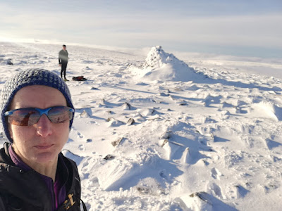
The big cairn isn’t the very highest point, so I backtracked a little for a selfie where I managed to look incredibly like my late mother:
A quick snack and an about turn to retrace our steps. Once we were back on the engineered track we trotted all the way back to Erica…
…albeit I paused every now and then to try to capture the immense prettiness around us:
By the time we were three quarters of the way back, the sun had turned the glorious powder we had experienced to that point into heavier, wetter snow. The consensus was that we had timed ourselves well; we’d not have liked to have been out much later in the day.
Bonus snap: a standard wire fence looking inconceivably chunky:
(*Thanks go to Conrad for bringing this route option to my attention as I don't believe I would have considered it as an option otherwise. It's longer than the popular route, but has the benefit of being largely on Access Land and on a good track.
**When I finish typing I shall give this to Mick to proof read. When he gets to this asterisk he will likely tell me that the summit never gets any closer to us, we get closer to it, but I’m sure you knew what I meant.)
(1hr55 up; 1hr25 down. A bit slower than my estimate, but then I'd not anticipated the snow conditions)


What a bonus with the snow and cloud inversions et al. A very worthy outing. You pace at just under 4 mph is nearer running than walking - much faster than our ascent That route was the result of much debate which is outlined in my blog post.
ReplyDelete