Start Point: Car Park on the A832 just E of Munlochy.
Distance: 17.2km
Weather: Mainly fine and sunny, but with a few drops of rain from a nearby shower when we reached the trig point.

We contemplated driving up the little yellow roads to reach the car park nearest to this hill, but my brief look on StreetView suggested that might be a bit stressful in a Bertie-sized vehicle, and anyway, we were happy to make a longer outing of it, starting at the main road. (Having now travelled those roads on foot: they're perfectly wide enough, with plentiful passing places and we would have had no issue taking Bertie up there).
The amount and speed of traffic on the main road was off-putting, but a small section of what was once, according to the map, a railway bed, allowed us to avoid all but a little bit along the busy road, before we turned off onto the minor roads (which were surprisingly well used, but not problematically so). We jogged the flats and downs and walked the ups, until eventually we reached the big mast and the entrance to the forest.
Once on the forest track, left at the first junction, then right at the T-junction were the directions I'd noted, but on reaching the T-junction it looked like maybe the muddy track opposite us, recently made by heavy felling machinery, may be of use. I had a little look and decided against, continuing instead to the small masts.
There we made (in hindsight) a bad decision, opting to follow a trodden line, then another forestry-works track, to skirt the hill to approach the summit from the NE. Here's a more detailed map snippet of that section of the outing, showing quite how circuitous a route we took:
Distance: 17.2km
Weather: Mainly fine and sunny, but with a few drops of rain from a nearby shower when we reached the trig point.
I've put some navigational notes at the bottom of this post. Whatever you do, don't follow out outward route to the summit. The return route is definitely the way to approach this hill!
We contemplated driving up the little yellow roads to reach the car park nearest to this hill, but my brief look on StreetView suggested that might be a bit stressful in a Bertie-sized vehicle, and anyway, we were happy to make a longer outing of it, starting at the main road. (Having now travelled those roads on foot: they're perfectly wide enough, with plentiful passing places and we would have had no issue taking Bertie up there).
The amount and speed of traffic on the main road was off-putting, but a small section of what was once, according to the map, a railway bed, allowed us to avoid all but a little bit along the busy road, before we turned off onto the minor roads (which were surprisingly well used, but not problematically so). We jogged the flats and downs and walked the ups, until eventually we reached the big mast and the entrance to the forest.
Once on the forest track, left at the first junction, then right at the T-junction were the directions I'd noted, but on reaching the T-junction it looked like maybe the muddy track opposite us, recently made by heavy felling machinery, may be of use. I had a little look and decided against, continuing instead to the small masts.
There we made (in hindsight) a bad decision, opting to follow a trodden line, then another forestry-works track, to skirt the hill to approach the summit from the NE. Here's a more detailed map snippet of that section of the outing, showing quite how circuitous a route we took:

The trig point was our objective.
We were within 100m of the trig point when we left the fire break and headed into the trees...

Trying to find our way through the trees, picking our way over the monster lumps and troughs of the old stumps, all nicely disguised by a bed of heather.
...I think that it then took us (incredibly and ridiculously!) over 30 minutes of thrashing around to get within 20m. At that point I did something I've never done on a hill before: I'd carried my jeans with me and now I put them on (on top of my running tights). We'd reached the dense gorse I'd read about, which turned out to be head-high in places. The jeans (and in Mick's case his walking trousers) provided valuable protection to the legs.
Fortunately we didn't do any more walking around in circles, but managed to dead-head to the clearing in which the trig point sits.
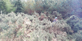 The 'clearing' was clear of trees, but not from out-of-control gorse.
 Summit Selfie. No photo of the view, because this is a Marilyn without a view.
We weren't daft enough to go back the way we'd come. Instead we followed the trodden line, which was faint in the extreme, but brought us out without any prickling, thrashing, ducking or clambering, on the mud track, from recent forestry works, that I'd discounted on our way up (although even if we had gone that way there's no chance at all that we'd have spotted the faint line and cut off into the trees in the right place).
There we stopped to remove our extra trousers and jogged back down to Bertie, taking a slightly shorter route having decided that the track opposite which he was parked (which looks on the map like a farm track, that heads straight through a farmyard, and thus would be excluded from Scottish access rights) is actually a public road. Whether or not that assessment was correct, we made it through without being accosted by person or animal.
With the complete lack of a view from the summit and the issues with reaching it in the first place (admittedly we didn't make the job easy for ourselves with our approach choices), this hill has the distinction of going straight into my "Top 10 Worst Hills Ever".
(Navigational notes: At the T-junction SW of the summit (at NH64759 58739) go straight on, following the righthand edge of the felled area. With trees again on both sides, at a tree-stump (ha! Good luck with identifying the right one!) at about 64873 58936 head off left into the trees. The line on the ground is really faint, but it leads to, and continues through, the gorse-hell clearing. If taking this line extra trousers aren't currently required, as the trodden line continues through the gorse reducing the prickling potential.)
We have between us had much to say about thrashing through forestry and we have both vowed to avoid it in future but we don't seem to learn. I did wonder what was the attraction of this apparently insignificant hill - is it a Scottish Marilyn?
ReplyDeleteAh! Research has confirmed my suspicion re Marilyn. As a list they do seem to cover a huge spectrum of accessibility from just stepping out of the car to this sort of thing, and then perhaps to serious winter ascents of the larger Scottish peaks.
ReplyDeleteIndeed, it is a Marilyn and that is why we were there. I would question the choice of leisure pursuits of anyone who opted to visit this summit for any reason other than because it's on a list they're ticking off. There are far better ways to spend one's time! (Although, of course, it will forever stick in my memory, unlike so many of the easier tops, so I suppose it does have some sort of perverse merit to it.)
DeleteMy family are from there and I have studied that map so often. I have never been and I am so envious.
ReplyDeleteIt is quite a trek from England to get up here, isn't it? That's exactly why, when we were sitting in Nairn wondering where to go next, and with a few days at our disposal, I thought we should grab the opportunity whilst we were nearby.
DeleteI probably wouldn't recommend bagging this particular hill when you're in the area, though...