The Road goes ever on and on; Down from the door where it began;
Now far ahead the Road has gone; And I must follow, if I can;
Pursuing it with eager feet; Until it joins some larger way;
Where many paths and errands met; And whither then? I cannot say.

[JRR Tolkien, Lord of the Rings]

Sunday, 19 December 2010

A Short Leg-Stretch

Layered up as if an arctic expedition was on the agenda, we left the house this morning and tootled over to the Chase.

I had doubted that long-johns would be needed under my Cascada trousers, but Mick was absolutely right – it was jolly nippy out. In fact, within five minutes of leaving the car (unusually for us, heading across the road into a bit of forest)

IMG_1953

I was wishing I had a buff for my neck and was thinking that my down jacket might have been more appropriate. Indeed, even my incredibly warm mountain cap wasn’t winning the battle against the cold, so up went my hood over the top, leaving just my nose and eyes on display; I stayed that way for the first four miles, when a bit of an incline finally got me warmed up.

IMG_1958Despite the unusually large number of cars in ‘our’ car park, it was quiet out and about, unless you count all of the people we encountered seemingly being pulled along by dogs. We had, for the first time, encountered a CaniX (or Cani-cross). It’s a sport that I’ve read about, but never encountered in the flesh. Everyone seemed to be enjoying it, and although Huskies and German Shepherds seemed to outnumber other breeds (at least of those competitors we saw) there was a wide variety of breeds:

 IMG_1969 IMG_1960 IMG_1962 IMG_1963 IMG_1965 IMG_1966

Diverging from the CaniX route, alongside the ponds we continued

IMG_1971

Then over the oversized stepping stones:

IMG_1975

Past the evidence of recent tree harvesting (where some of the ruts housed frozen-over puddles, hidden by snow; I was surprised quite a few times when I thought I was on solid ground, only to have ice give way beneath me):

IMG_1977

Then, finally, the opportunity came to warm up, as we headed off uphill:

IMG_1978

(hmm, looking at that photo, I’m pretty sure that we didn’t go that way!)

With so few people around (other than the runners and dogs), there was lots of virgin snow, and for a long time I resisted. Finally I could resist no more and a snow angel was born:

IMG_1982

There may have been few people out and about, but when we got there, the visitor centre cafe was heaving. With all of the tables taken, people were standing around drinking their tea and whilst I desperately wanted a cup of tea, standing in a crowded room drinking it wasn’t quite what I had in mind, so onwards we went.

A couple of snowballs were thrown as we crossed the open ground nearby (but a full-blown snowball fight avoided) before we re-entered the forest to return to the car.  Feeling rather robbed of my anticipated cup of tea, we didn’t turn towards home as we left the car park, but rather headed to Slade Lodge tea room (which is a whole order of magnitude nicer than the visitor centre too) where pots of tea and various edibles were consumed with relish before we tootled back home to tackle the chores.

Our short-but-enjoyable route looked something like this:

image

Tuesday, 14 December 2010

Martin’s Christmas Walk – Sunday 12 December

Thanks to an unexpected and winding 10-miles diversion due to a level crossing being closed, and some very icy (not to mention steep) roads which made me squeal and shut my eyes (fortunately I wasn’t driving), we cut it rather fine for the ‘10.15 prompt’ start time for Martin’s Christmas Walk,. It was with just two minutes to spare that we pulled into the penultimate parking space at Wettonmill.

With no time to stand around getting cold, we were off – all 24 of us – to pick up the path alongside the River Manifold.

Barely had we got into our stride when Sue pointed out what looked like a man-made tunnel ahead and above us:

IMG_1926 it turned out to be Thor’s Cave which an information sign told us had ‘been formed over thousands of years by the effects of water and wind’. Apparently ‘the name may be a corruption of ‘Tors’ … and some people think it comes from Thor, the Norse god of thunder’. Personally, I’ll go with the ‘tor’ explanation as it does look toresque.

It would have been rude not to pop up to have a look around the cave (not to mention to enjoy some CCS and some Fudge Brownies, whilst enjoying the views from its elevated position) and it was a worthwhile diversion:

IMG_1932 IMG_1929 IMG_1930 IMG_1931Back down to the valley floor we went, from where much chatting and some good views took us up lumpy bits, along lanes and across fields

IMG_1941

until we landed, just before 1pm, in Hopedale, the home of the Watts-Russell Arms. We filled the pub, which did an excellent job in serving us some very tasty lunches and some equally tasty beer.

As I often find with a big pub lunch accompanied by beer, I could quite happily have sat in the warm all afternoon, but Martin is a hard taskmaster and after a good break he had us all removing the blue ‘shower caps’ from our shoes and venturing back outside to continue on our way.

IMG_1943

I’ve looked at a map since the walk and find that I paid so much attention at the time that I have no idea what route the afternoon took, but I do know that after another CCS and brownie break we popped over the top of Ecton Hill. It was one of those excellent little hills that give incredible views, and there was just enough light left to appreciate those views, although not quite enough light to take passable photos (or at least not on my camera, although that could have been the operator as much as the equipment).

Sue couldn’t resist dancing a jig on some of the snow remaining by the summit:

IMG_1949 (actually, she was throwing snow balls at the rest of us)

and a bit more snow was remaining on our route down:

IMG_1950

By the time we came out at a very interesting looking house:

IMG_1951the light was so poor as to make photo-taking nugatory, so the camera didn’t come out again as we ambled along the Manifold Valley in the dark, to return to Wettonmill.

It was an excellent walk in good company, with a commendable amount of well-rewarded upness (all a bit of a shock for my legs which until three days previously had forgotten what a hill was). In fact, I was so taken with the route that I think that we’ll return on a day with a bit more daylight to see all of the sights again – although I will have to consult Martin first to find out what route we actually took!

Apparently the distance stat was 10 miles. No idea to what height the upness amounted. (Edit: It turns out that the distance was 11 miles and that the upness was around 2500 feet.)

Martin's report of the outing (plus a slideshow of pictures which show much better what the surroundings were like) is here.

Friday, 10 December 2010

Three Walks, Two (Half) Days, One Camp

Walk 1

The entire purpose of the trip was to visit my father’s tree, so a quick jaunt up Dinas Oleu was our starting point.
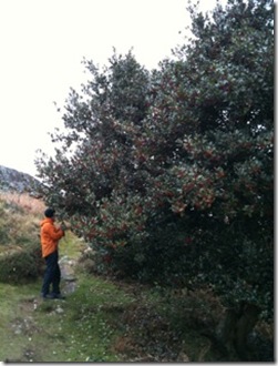
Dad's Tree

Everything was in good order, so we left the birds enjoying the plethora of berries and returned to the town (Barmouth, that is).

Ordinarily, having walked up to the tree, we would continue onwards into the Rhinogau to spend the night, but aside from my (lack of) fitness issues, we’ve walked all of the obvious routes before, so for this trip we opted to tootle up the road a few miles to Tal-y-bont – first, however, there was a massive All Day Breakfast to be eaten in the Milk Bar.

Walk 2

The free car park in Tal-y-bont saved us from having to root around for a suitable overnight parking spot and soon we were walking up through the woods, alongside the Afon Ysgethin – a route that I’ve not walked for at least 20 years. I seem to recall that back then that path would be absolutely heaving on a summer’s day.

IMG_1899 Up we went, to pick up a track onto open land, which afforded us views of the smattering of snow around us. Soon, however, the cloud started to descend, swiftly followed by rain arriving.

IMG_1903We were positively sweltering, what with the positive temperature (a whole +2 degrees, according to the thermometer on my backpack) and the unaccustomed effort of carrying a pack up a slight incline, but the ice on the path, and the frozen falls on the crags alongside Llyn Bodlyn told us that, in common with the rest of the UK, it had been chilly of late.

IMG_1905With the terrain being typical Rhinogau bogs (albeit frozen bogs), tussocks and rocks, we doubted that we would find a good pitch around Llyn Bodlyn, even though the lack of visibility higher up had caused us to decide we would cut short there.

Happily, at the end of the track, just below the dam, there was a perfectly flat grassy area and we wasted no time in throwing the tent up between showers.

IMG_1914 Next to us the outflow from the llyn was solid, but slightly further down it was running, so gathering water wasn’t a problem.

IMG_1907 The llyn was still lightly frozen over too (and I took some incredibly poor photos to try to capture it):
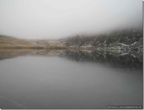
IMG_1910 By just after 3pm we were tucked up in the tent, which was now enveloped by cloud, as the wind picked up outside and as the rain set in for the night.

Fast forwarding by 15 hours, we awoke this morning to find that the rain had washed most of the immediate snow away and that the cloud was still all around.

“It’s only a kilometre. How bad can it be?” I said to Mick on the subject of my proposed yomp down stream to pick up a path that would lead us back to our starting point. Mick gave me The Look. He’s walked across this valley before, and knew exactly how it could be.

Happily, the positive temperature hadn’t been around for long enough to fully defrost the bogs, so the going was easy and our return was entirely uneventful. We even popped out from below the cloud for the latter stages of the walk.
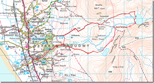
Route Map

With our tiny valley stroll amounting to a whole 9 miles over the 2 half days, we were back at the car by mid-morning, and there was no disagreement that another All Day Breakfast would go down a treat ahead of Walk 3.

Walk 3

Even after a monster fry up had been consumed, there was still a big chunk of day remaining, so a walk in the woods was called for, to go and have a shufti at the bothy we could have stayed in last night.

Past ‘group abuse’ issues have caused a locked gate to have been placed to stop vehicular access to the bothy, but we discovered on our wanderings that it’s still possible to get within an easy beer-and-coal hauling distance of the place.

Approaching, the building looks impressive as bothies go:

IMG_1923

and inside we found five rooms (not to mention a quantity of rubbish left by those who are perfectly happy to haul full drinks bottles and cans of food in, but aren’t capable of carrying the much-lighter empties out. We did our good deed by collecting most of it up and taking it with us). There’s even a privvy provided (picture taken from the same location as the one above)

IMG_1924 but apparently the twenty-five paces from bothy to outhouse is too much for some people, based on the brown-stained toilet paper littering the area in between.

It’s a bit of a strange location for a bothy (being in such a low-land and easily accessed area), but armed with the firelighters and candles that we’d taken with us, it would no doubt have served us well had we chosen to stay there last night.

And so

By late afternoon we were home again, having not seen a single other person out walking across all three of our strolls.

It was far from our shortest backpacking trip in the area in terms of hours (we once squeezed in a quick overnight in the Rhinogau during which we were away from home for just 24 hours – but, being in the height of summer, managed to walk much further then than on this trip), but it’s got to win the award for our shortest mileage backpacking trip ever. Still good fun though, even in the adverse weather.

National Move Your Caravan Day?

This is the fourth different static-caravan-on-the-move that we've found ourselves behind in the last thirty miles.

That's not to mention the cattle trailer, the JCB and the two big lorries. If we get past this wide load then we're taking bets as to whether it will be a tractor or a milk float that we encounter next.
Sent using BlackBerry® from Orange

Thursday, 9 December 2010

Tent, not Bothy

As is often the case, the final decision was made over an All Day Breakfast (in a cafe with serious apostrophe issues), when afternoon was almost upon us and time had run out for pontification.

Either plan could have been executed in the four hours or so of daylight remaining, but it was 'tent on a hill' that won over 'bothy in the woods' for tonight. So, up a pretty stream and along a valley we took ourselves.

With the weather being less than ideal (rain was not on the forecasts I saw) and with the cloud base getting lower and lower, there seemed little value in climbing up to a higher llyn, or onto the ridge.

We may as well stay below the cloud base, we thought and so at the first flat spot alongside a llyn (that I would name but for the map being inaccessible as I type this), up went the tent, even though it was a little early.

The rain let up whilst we pitched, which was a blessing, but within half an hour the cloud was down below us and rain is now falling again. Let's hope tomorrow brings drier weather.


Sent using BlackBerry® from Orange

Wednesday, 8 December 2010

Packed

For the first time in an outrageously large number of months, our backpacks are packed.

The only question now is: on a hillside, or beside a roaring fire in a bothy in the woods?

Falling Frost

IMG_1896b I didn’t post this photo yesterday because, aside from the power lines, I couldn’t work out why there was a white ‘v’ in the sky on the left hand side.

Mick’s just looked through the photos he took and explained that he waited for a while to capture some of the frost falling off one of the cables.

Tuesday, 7 December 2010

Hoary!

Walking through the office today, once daylight had hit, I happened to glance out of a west-facing window which affords a view of a field and trees (rather than out of my side of the office, which has a view of other office buildings). Rushing back to my desk I texted Mick: “It’s a gorgeous hoary day out there. Go for a walk. Take the camera.”

I’m not sure that I’ve ever seen such a fantastic display of hoariness combined with lying snow.

IMG_1881aIMG_1883a And my favourite (albeit best viewed in full size):

IMG_1894aAnd through all this weather, our postman is still wearing his shorts when he delivers the mail!

Saturday, 13 November 2010

Productive Mapping Day

Our TGO Challenge route is planned, plotted and printed.

Now all we need to do is to work our way up the stand-by list to get ourselves a place!

Monday, 8 November 2010

TGO Challenge

Arriving home from work after a monstrously epic day, it was with glee that I spotted the A4 envelope on the doormat with the giveaway post-mark which told me that it was news of our TGO Challenge entry.

Ignoring the fact that it wasn’t addressed to me, I ripped into the envelope and scanned the contents. “I am very sorry to tell you'” were not the words I was hoping for.

Picking myself up from the immediate crush of disappointment, I read on, and found good news in the next paragraph: we are high enough up the stand-by list to mean that we will plan next year’s walking on the basis that we will be taking part in the TGOC.

News of our fate with our Challenge entry was supposed to be the deciding factor as to which of two potential walking plans we went with for next year (being the next Big Walk, or a series of shorter walks, including the TGOC). Perhaps we were just using the Challenge to put off making a final decision as a quick chat with Mick this evening has revealed that we’re not greatly nearer to making that decision, but that the current favourite option is the previous non-contender known as ‘Plan C’.

P5140137

Sunday, 24 October 2010

So New; So Close

One of the things I like about Geocaching is how it can drag me to places I wouldn’t have ordinarily have thought to go.

Today was a good example. Last night a visit to the Geocaching website revealed a cache within a sensible jogging distance (on my scale of sensible distances, not on Mick’s rather larger scale!), so this morning, under clear blue skies, off I set to find it.

We’ve lived in this village for over 8 years, and yet as I huffed and puffed my way along, I realised that never before had I been along these lanes. Delightfully quiet lanes they were too. In half an hour I was passed by two cars.

Even better, arriving at the cache site, I found not just a Geocache but a local nature reserve that has recently been established with permissive paths through the surrounding fields. I must go back some time to explore further.

And all without straying more than 1.5 miles from the front door!

Sunday, 17 October 2010

The Cabbage Patch 10

The Cabbage Patch is a pub in Twickenham, and each October it hosts a 10-mile run which takes a nice flat route mainly following the Thames.

Mick had decided a few weeks ago to join Juan and his brother Raf in taking part, and so the three of them were to be found loitering around just up the road from the Cabbage Patch just before 10am on this fine autumn morning.

With only a couple of minutes to go until the off, the traffic was stopped and the runners led to the starting line:

IMG_0995where they all waited patiently for about 30 seconds, until the claxon sounded.

With a field of around 1600, Vic & I (spectating, along with baby Tilly) doubted that we’d spot any of the boys as they passed, but we did manage to pick Mick out. He’s in this photo (bet you can’t spot him; Raf is also in this photo, even though we didn’t see him at the time):

IMG_0998

Mick’s in this one too:

IMG_0999

After a bit of a stroll and a stop for a cup of tea Vic, Tilly and I made our way over to the finish line where I took a photo of a random stranger crossing the line just to make sure that the position of the sun wasn’t going to scupper me snapping Mick as he crossed the line:

IMG_1000See – perfectly possible to take a clear photo! 

Things didn’t work out quite so well when I saw Mick coming as I managed to make him look headless:

IMG_1002

It turned out that the three chaps were well matched to run together. There was no loitering around waiting for them all to finish. Raf came in first in 1.21.46. Mick was next in 1.22.38. And Juan was only just behind, finishing in 1.23.41.

Here they all are looking fresh as daisies a few minutes later:

IMG_1004 

Based on the enthusiastic discussion of the event afterwards, I suspect that they’ll be posting entries off again next year.

Saturday, 9 October 2010

On The Limestone Way – Again!

Yesterday evening I did as I usually do when I get home from a walk – I measured the route and added it to my log. Then I looked at my mileage for the year to date and realised that I’d finished the day just 1.5 miles short of my previous highest annual total.

The obvious thing to do would have been to just pop out for a little circuit from home this morning, but the thought that immediately struck me was that I hadn’t had much time with the chaps on the Limestone Way yesterday afternoon, and therefore we should get up early this morning and go an join them again.

With Roger (plus Dalmatian Rollo) also swelling the numbers, there were six of us today as we left The Miners Standard and almost immediately yesterday’s participants were stunned to find clear ‘Limestone Way’ signposts.

The clear waymarking continued, allowing swift progress to be made without time spent poring over the maps.

Soon we started encountering D of E groups, of which there were lots and lots today. Other signs suggested that today’s plethora of D of E groups wasn’t an unusual occurrence:

IMG_0971 Interesting features were passed on our way to Youlgrave, with the big craggy bits above the Hermit’s Cave and the twin boulders of Robin Hood’s Leap.

Some attractive woodland and some more fields (with more of those awkward stiles) took us to Youlgrave, which is where Mick & I were to leave the group to form a circuit back to Winster, but first I had my sights set on a tea room.

The cafe at the YHA served our purposes, and the drinks and sandwiches went down well as we all optimistically thought that the pause in the walking would give the sun the chance to burn through the greyness.

It didn’t, and it was still grey when Mick & I parted company from the group a few minutes later:

IMG_0972

Everyone grins at our departure, except for Mick who pouts a little

Off went John, Gill, Viv, Roger and Rollo, following the river to the west, as we followed it east for a short while. Lovely it was too, if a touch busy (two more D of E groups met in the half mile stretch we walked). All went quiet as we turned away from the river.

The bit of the outward route that went past Robin Hood’s Leap and the Hermit’s Cave was followed again on our return, except this time we took a detour up to see the cave.

We weren’t at all sure what it was that we were looking for, with ‘cave’ being used to describe anything from an overhanging rock to a proper big cavernous thing, but after brief consideration we discounted the first opening we came across:

IMG_0976Following our instincts, it wasn’t long before we came across what was indisputably the cave, albeit we couldn’t quite work out why the railings were needed to keep people out of a cave that must only measure something like 4 feet by 15.Perhaps the big crack in the ‘ceiling’ rock has something to do with it?

IMG_0978 

Just to the right of the cave men were clambering up rocks and we paused to watch:

IMG_0982Leaving our outward route once again off we headed towards Upper Town, albeit on our way there a short distance was covered in the wrong direction before we realised the important difference between ‘up’ and ‘down’ (‘up’ being the direction in which we were meant to be going).

A joint award was given for ‘most unexpected animal encounter’ when we came across a field containing sheep, a tiny horse, two ostriches and two emu (for the avoidance of doubt, it was the latter two species that were unexpected!). This chap came over to us at a trot, making us most appreciative of the tall fence separating us:

IMG_0987

The sun was just starting to break through as we headed back towards Winster:

IMG_0986 And by the time that we left The Miners Standard (where we had been sampling the beer that came highly recommended by the chaps who stayed there last night), the blue sky was winning.

The stats for the day were just over 9 miles walked with 1700 feet of ascent and a ‘good day out’ rating of 100%.

Friday, 8 October 2010

On The Limestone Way

Having achieved a pass-out from his household duties, off set Mick yesterday morning to meet up with John, Gill and Viv for a jaunt on the Limestone Way.

Rocester is the starting point of the Way and, after a public transport adventure (which went like clockwork) that’s where Mick met up with his companions for the day to set off in a generally northerly direction.

The late start demanded so as to allow people to travel to Rocester also gave the early misty greyness chance to burn off, so it was quite a nice day by the time they were underway:

IMG_0961 In the meantime, I was sitting at my desk, looking out of the window and thinking ‘Nice day for a walk’. A few minutes later I had requested a half day’s holiday for today.

After a pleasant afternoon’s walking, featuring donkeys:

IMG_0952

coos:

IMG_0958

giant red toadstools:

IMG_0957

and (most importantly) good company:

IMG_0953the party of four pitched up at Bank Top Farm in Fenny Bentley where they soon established ‘green tent corner’:

IMG_0963before hot-footing it to the better of the two pubs in the village for beer, food and beer.

The stats for the day were 11.5 miles with 1700 feet of ascent.

Today dawned as grey and misty as yesterday, but with a greater degree of dampness and, unlike yesterday, it didn’t burn off by late morning.

The ‘Phreerunner Effect’ didn’t have its usual effect today, and it was still murky when Martin and Rick joined the party for the day. By 10am off they had all set in a generally northerly direction … or at least that was the plan.

IMG_0965

A bit of the Tissington Trail featured to get the group back onto the Way (having detoured to Bank Top Farm last night), and having reached Tissington it would have been rude to shun the tea room there, so in they all popped for some light refreshment.

They were still there when I left work at 11.45, and when I reached the car park at Winster (having done a thorough tour of the place looking for the very pub I had driven past as I arrived) they were just having a few navigational issues in leaving Parwich. It is, of course, understandable on a not-sunny day that six people can walk for some distance in a southerly direction before realising that the direction doesn’t feel quite right for a south-to-north walk.

A lunch break soon after called for another pause, all of which was to my benefit. I had been concerned that by the time I arrived they would have all but arrived at their night-stop, but as it went I got all the way to just-north-of-Brassington before I met them.

Around I turned, and finding our way across the fields became simple until we reached Grangemill as we were retracing the steps I’d just walked. The stiles didn’t get any easier, mind. The stiles on the Limestone Way were definitely not designed for ease of passage!

A golden orb vaguely tried to make itself visible through the murk, but the best it achieved was causing faint shadows for a few three-second stretches, and so the views were still curtailed as we past some massive quarries and crossed more fields to reach Winster.

The party split at The Miners Standard pub, where those completing the whole route were to camp the night, whereas Mick, Martin, Rick & I made our way back to the car park and thence home.

Mick’s stats for the day (excluding the leaving-Parwich diversion) were 13 miles walked with 2200 feet of ascent. My stats were 9.75 miles walked, with 1300 feet of ascent.

All of the group photos taken outside of The Miners Standard would imply that I wasn’t there, whereas the reality was that everyone trusted me to be photographer:

IMG_0967From my point of view it was a very pleasant leg-stretch after another few weeks of inactivity, and it was good to catch up with the others (and to meet Gill for the first time). From Mick’s point of view it was his first night spent with Connie, and (believe it or not) his first ever night of solo camping, and it seems that he had rather a good time too.
