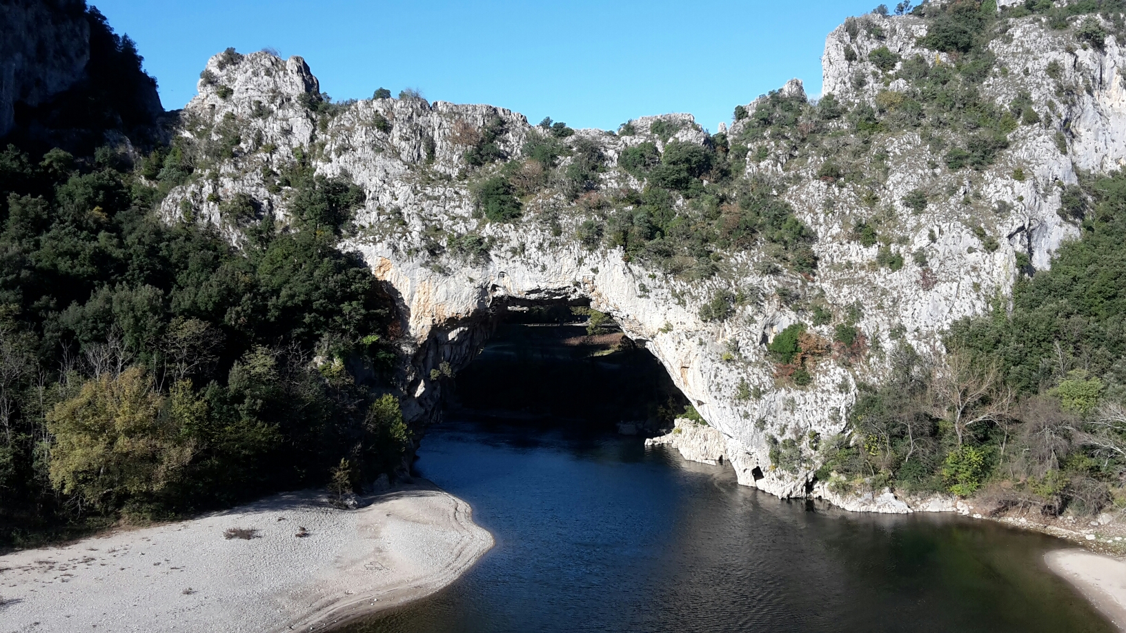
There has been walking over the course of the last three weeks, but nothing to write home about. Until yesterday it’s mainly been touristic wanderings, although we did take to the GR4f for a couple or three miles when we were in Vallon-Pont-d’Arc a couple of weeks back. That was a bit of an ill-timed outing, in that we set out on a 10km route with only about 2 hours before sundown, resulting in a fast march back along the road when the light started fading rapidly out of the day. We did get to see the spectacle of the natural arch of Pont d’Arc, though:

The small print is that this photo wasn’t taken when we walked there, as the light was a bit dull by then. This snap was taken the following morning when we returned in Colin.
We’ve moved on further south since then, finally hitting the Mediterranean coast about a week ago (and thinking about it, we did also take a 5.5 mile walk when we hit the Med at the Carmargue. Impressively, not a single foot of ascent featured in that outing. Flamingoes did feature; lots and lots of them).
The significant factor which led to there being trail walking both yesterday and today (and, indeed, the very reason why we are currently in Port Vendres at all) is mapping. On my phone I have IGN 1:25k mapping for the Pyrenees, which extends far enough north along the Med coast to cover Port Vendres, thus I knew in coming here that there were multiple walking routes from the town, some of which looked particularly good.
Yesterday we took a stroll up to the fort that you should just be able to make out on the rightmost lump, above the town, in the snap below, before dropping down to the picturesque harbour in Collioure, and picking up another trail which led us back to Port Vendres.

Today we went coastal, starting out with the good view above, over the port and town of Port Vendres. Undulating along, it only took us half an hour to catch up with the group of ramblers who had set off just as we were getting out of bed. They took a short cut at the military base, whilst we followed the path around two sides of it. I’m sure in the UK you wouldn’t get razorwire at head height immediately adjacent to a narrow path:

There then followed a succession of little bays and inlets. From the first we had a good view back to the lighthouse at Cap Béar:


Bonus better snap of the lighthouse from further along the way
In the direction we were headed pictures weren’t as good, due to the sun being in our eyes:

Can’t complain though, as for the first half of the outing we were in our shirt-sleeves, enjoying the warmth.
It appears that Mick was after dipping his toes in the sea as we crossed the cove shown below. The continuation of the path was up the concrete steps set into the rock, not far behind Mick:

At Plage de Bernadi it was time for elevenses and a bit of fun with a few selfies. Mick has vetoed me showing the silly ones, so here’s a sensible one of us sharing a flask of coffee, having already polished off our croissant/chocolatine:

Away from the coast was then our direction, and into the vineyards:

Where, just after crossing a road, we missed a turn, finding ourselves ten minutes later back on the same road, but slightly further up. Throwing in a loop, we returned to the original point of departure from the road, and wondered how on earth we’d missed the ‘you need to turn here’ indications the first time around:

Twisting and turning, occasionally heading up washes, we marvelled at the gnarled nature of the old vines,and at the neatness of the terraces:

Until suddenly we were dropping back down from Col de Migt, with Port Vendres only a short way in front of us. The path and the waymarkers suddenly disappeared as we hit the road, but no bother – the most obvious route back to Colin was on roads anyway.
Having forgotten to take the Garmin Gadget, I don’t have an exact distance, but I reckon it was arounnd 7, maybe 7.25 miles, with 1500’ of ascent (I’m going with my Fitbit’s assessment of the ascent; it feels about accurate). A fine outing!


Glad to hear that others take the wrong route from time to time. As I get older I still do that, but I reckon I discover the error more quickly!
ReplyDeleteWe are having decent weather but having to scrape ice off windscreens and all the Lakes hills are covered in snow. I'm off to do another section of the Wyre Way tomorrow.
It's a nice coastal path. I used some of it on the penultimate day of GR11. (Or, not quite GR11!)
ReplyDelete