Carn Faire nan Con (370m; NH395591)
Starting Point: Layby on A835, 400m north of the obvious access track for this hill.
Distance and Ascent: 5.5km; 330m
Weather: Dry but mainly overcast

The first of three out-and-back hills today. Mick, scarred from yesterday's experience, opted to sit this one out so I was on my lonesome as I huffed and puffed my way up the pylon-maintenance track that was to lead me a good distance towards my hill. On reaching the high point of the track I was heartened to see a faint ATV track leading through the heather and tussocks that lay between me and my hill. It didn't remain helpful for very long, then it was a slog through pretty rough terrain, during which I wondered whether I'd accidentally dropped my hill fitness somewhere on my way up. Or maybe I just lost it over the last couple of months. Either way, it was a harder ascent than it ought to have been.
The fine viewpoint of the summit was, however, worth the effort:
Excuse the fact that I'm obscuring the view in the first snap.
A retracing of steps (more or less) had me back at Bertie ready for elevenses, but as the layby didn't have any separation from the fast-moving traffic, I put a pause on coffee and butteries, and we headed off to a forestry car park near Contin.
Torr Achilty (252m; NH447550)
Starting Point: Forestry car park N of Contin.
Distance and Ascent: 5.5km, 250m
Weather: Some sunny intervals, and the edge of a shower right near the end.
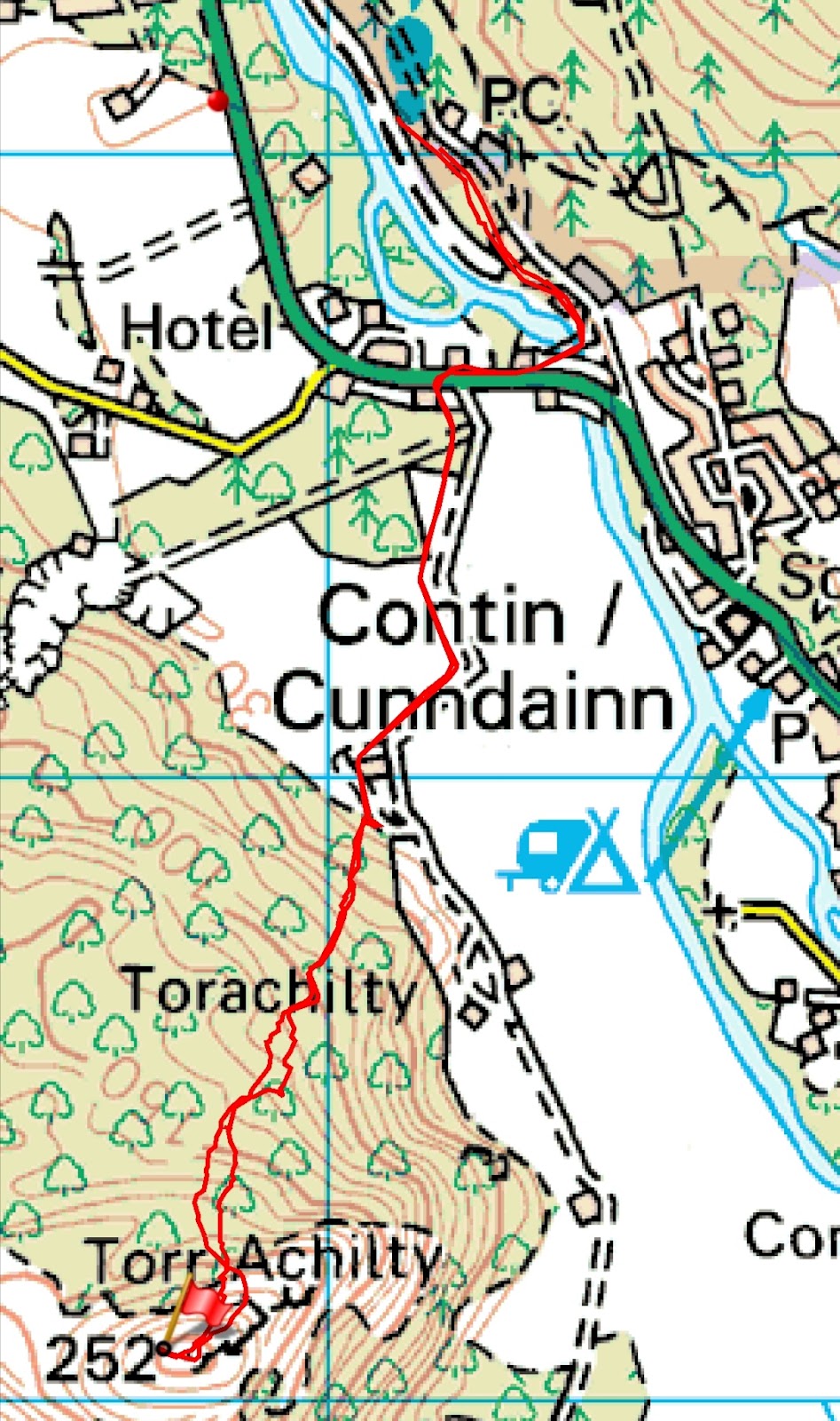
By the time we'd moved to this car park and had elevenses, it was lunchtime, but thinking this would be a quick 1-hour job*, I postponed lunch until my return.
Mick came with me as we walked back to the main road, across to the track-end where most people park for this hill, and up the farm track to the point where I stepped over a fence to attack the hillside. Mick then turned back, as I headed off into the bracken.
Thanks to cattle, there were easy routes to be found through the bracken, and the initial going once I reached the natural woodland wasn't bad either. It was only as I was reaching the top edge of the woods that the going became really rough. Routing myself such that I had to negotiate a couple of very small crags didn't help, nor did the fact that I was stopping far too often to flick a dozen or so ticks (each time) off my trousers. Definitely the biggest tickfest I've ever encountered!
Starting Point: Layby on A835, 400m north of the obvious access track for this hill.
Distance and Ascent: 5.5km; 330m
Weather: Dry but mainly overcast
The fine viewpoint of the summit was, however, worth the effort:
Excuse the fact that I'm obscuring the view in the first snap.


A retracing of steps (more or less) had me back at Bertie ready for elevenses, but as the layby didn't have any separation from the fast-moving traffic, I put a pause on coffee and butteries, and we headed off to a forestry car park near Contin.
Torr Achilty (252m; NH447550)
Starting Point: Forestry car park N of Contin.
Distance and Ascent: 5.5km, 250m
Weather: Some sunny intervals, and the edge of a shower right near the end.
By the time we'd moved to this car park and had elevenses, it was lunchtime, but thinking this would be a quick 1-hour job*, I postponed lunch until my return.
Mick came with me as we walked back to the main road, across to the track-end where most people park for this hill, and up the farm track to the point where I stepped over a fence to attack the hillside. Mick then turned back, as I headed off into the bracken.
Thanks to cattle, there were easy routes to be found through the bracken, and the initial going once I reached the natural woodland wasn't bad either. It was only as I was reaching the top edge of the woods that the going became really rough. Routing myself such that I had to negotiate a couple of very small crags didn't help, nor did the fact that I was stopping far too often to flick a dozen or so ticks (each time) off my trousers. Definitely the biggest tickfest I've ever encountered!

The easy-going bit of the woodland
It was only once I was on the small plateau that the heather was short enough to make the going easy, but by then it was just a hop, a skip and a jump to the cairn marking the high point.
What views! I'm not sure Mick would have appreciated the roughness of the upper reaches of the woods, but he certainly would have enjoyed the views from up there.

I wondered as I set off back down whether any of the showers I could see would hit me. Obviously, I hoped they wouldn't, but at the same time, given the forecast, I couldn't believe I'd stayed dry thus far.
The descent seemed as slow as the ascent had been, as I picked my way carefully down, until finally I was able to hop a fence back onto the track.
About half way along that track the rain finally hit me and although not heavy it looked like it was going to last long enough to warrant some waterproofing. I opted for my 'disposable' (allegedly; I've had it since 2008!) poncho. An underrated item, I reckon, as it kept both me and my pack dry, even if I undoubtedly looked a bit silly wearing it.
(*1hr36 was what it took. Surprisingly over 15 minutes slower than the first hill, even though it was the same distance.)
Cnoc Mor (269m; NH490569)
Starting Point: Forestry car park at Blackmuir Wood, at the S end of Strathpeffer.
Distance and Ascent: 3.25km; 170m
Weather: Dry with some sunny intervals

I could happily have left this hill until tomorrow, but having decided to comply with Forestry Scotland's polite requests not to park in their car parks overnight, and with the absence of other overnight options nearby (that we knew of, at least), it made sense to do this hill today.
It was by far the easiest of the trip. Aside from the short distance and small amount of ascent, there was a path the whole way (even if I did initially walk about ten paces past it as it left the forest track).
Alas, there wasn't a view from the top...
 I reckon this was the highest point, although I did also visit the trig point, which is a bit bleached out, but just visible on the other side of the fence.
...but I didn't have to detour far to be able to see beyond the trees:
 Another retracing of the steps took me back to Bertie, although not without pausing for a few snaps of the wood carvings outside one of the houses alongside the forest track:
Cnoc Mor (269m; NH490569)
Starting Point: Forestry car park at Blackmuir Wood, at the S end of Strathpeffer.
Distance and Ascent: 3.25km; 170m
Weather: Dry with some sunny intervals
I could happily have left this hill until tomorrow, but having decided to comply with Forestry Scotland's polite requests not to park in their car parks overnight, and with the absence of other overnight options nearby (that we knew of, at least), it made sense to do this hill today.
It was by far the easiest of the trip. Aside from the short distance and small amount of ascent, there was a path the whole way (even if I did initially walk about ten paces past it as it left the forest track).
Alas, there wasn't a view from the top...
...but I didn't have to detour far to be able to see beyond the trees:

Incidentally, we would have gone up Ben Wyvis (Munro) today, if it hadn't been for such an unfavourable forecast. I know I didn't go high today, but based on my observations, the weather would have been perfectly acceptable to head up above 1000m. Harrumph.


You don’t have to go to the highest points to have a lovely walk. It looks like you did.
ReplyDelete