The Road goes ever on and on; Down from the door where it began;
Now far ahead the Road has gone; And I must follow, if I can;
Pursuing it with eager feet; Until it joins some larger way;
Where many paths and errands met; And whither then? I cannot say.

[JRR Tolkien, Lord of the Rings]

Thursday, 30 May 2024

Mendick Hill, Black Mount and Broomy Law

 Sunday 26 May

After spending a lovely sunny Saturday afternoon in Arbroath, sampling wares such as the Arbroath Smokie Fish Pie from Cel's on the harbour...


...and some expensive and not particularly nice chips from a harbour chippy, heavy rain came in overnight.

Faith was put in the forecast that the rain would abate around noon and not restart in earnest until 4pm, so towards this collection of three hills we headed. 

Overview of the three gpx files I recorded
 
Mendick Hill (NT 12155 50530; 451m)
Start Point: Minor road opposite monument to N of Dolphinton
Distance and ascent: 7.5km, 270m
Weather: if I got rained on on this one, it wasn't more than a few drops
I did the head of the lollipop clockwise
 
Most people (or most people who log their hills on hill-bagging.co.uk) approach this hill from West Linton Golf Club. That didn't suit a Bertie-sized vehicle, so I opted to approach from the opposite end of the track that runs past this hill. Poring over the map, I'd contemplated continuing along the track to take the 'usual' route, or to go up the SW spur, but decided to defer that decision until I was on the ground, looking at what lay before me. 

Having decided that the more direct route looked feasible, I would have started ascending before Ingraston, except that field held both sheep and cows, and I wanted to disturb neither. As it went, I did disturb three (one with a spindley-legged new-born) who were on the track, two of whom took fright even though I'd explained to them quite clearly what I was doing and reassured them that they needn't moooove on my account.
 
Once through the next gate, opposite the farm buildings, the hillside was attacked head on. Eeeeh, that was steep! Things then got easier from a gradient point of view, but was harder than expected underfoot (not the first time I've been caught out by rough terrain in these parts, where I expected grazed fields). Fortunately, the route worked out nicely from a gate point of view - every fence I encountered had one,  even if only one of them was of the opening variety. 
 
It was somewhere towards the summit, making my way through long, wet grass that I became aware that I wasn't the first person up this hill today. There were definite shoe-shaped imprints in that grass at the right distance apart for someone just a touch taller than me. 
 
I'd intended going back more or less the way I'd come, but my attention was elsewhere as I left the summit and by the time I realised that I was descending steeply, rather than following the ridge, I didn't feel inclined to reascend. Probably a good call for two reasons: friendlier terrain and I had a stoat/weasel run in front of me as I made my way back along the track. It's ages since I last saw one.
 

Okay, so in the scheme of Marilyn-bagging terrain, this is reasonably tame, but it felt rough compared to my mental picture of grazed fields
 
Summit views

 
Back at Bertie, I shoved a piece of fish pie into my mouth, then it was onwards to...
 
Black Mount (NT 07995 45965; 516m)
Start Point: Track end to NE of Kirkhouse (no parking here)
Distance and ascent: 4.7km, 250m
Weather: Showers, only one heavy/long enough to get me wet

I had intended to tackle this one from the same start point as Mendick Hill, but in the interests of me fitting in all three hills and making it to Shap by bedtime, I begged a lift to the track end from Mick, even though it meant him doing a bit of back-and-forthing, as there's nowhere to park in the vicinity of my start point. 

Beyond Kirkhouse the track became a lovely grassy one, which took me through a patch of woodland then through a field of sheep, before making me huff and puff to reach a gate from where I would strike off up the hill. The gate proved to be in the 'wrong' fence, and didn't allow me access to where I needed to be, but a bit of limbo dancing (where I'm sure many have limbo danced before) got me to the right side, and upwards I went.

The steepness was made more difficult by the area of landslip that, whilst stable, wasn't an entirely firm surface. It was just before I got back on to solid ground that the rain started.

By the time I got to the top of the steepness, picking up a trodden line for the relatively-level final kilometre to the summit, I was contemplating donning something waterproof. If I had taken the trouble to do that, I wouldn't have been quite as cool when I reached the trig point...


It's seen better days. What did someone attack it with, and why?

Before I tripped over the fence behind me
 
...and maybe if I hadn't been so cool I wouldn't have tripped over the fence as I stepped over it to investigate whether the ground was higher on the other side. 

Not fancying the steep, loose surface of the landslip on the way down, at an appropriate point I stepped over the fence (more elegantly than at the summit) and cut a corner. That involved wet deep heather, new growth bracken, and lumps and holes hidden by all of that. Fortunately, the fence I needed to cross on the way was also easily step-overable and soon I was trotting back along the track, summoning Mick on my way to come and pick me up from the track end. From there it was another short drive to...

Broomy Law (NT 08547 42876; 426m)
Start Point: track end at NT100444
Distance and Ascent: 4.4km, 170m
Weather: Bit of rain early on, then dry

 
I'd identified a pull-in just E along the road from the track along which I was going to start my approach to this hill, but what I hadn't been able to see on StreetView was how slopey it was. That wouldn't have been a problem if my plan hadn't been for Mick to cook tea whilst I was out, so that we could eat as soon as I was back, so that we could reach Shap before bedtime. Fortunately, a few yards away from the pull-in, there was a large track entrance and it seemed unlikely anyone would want access to the gateway at that time on a Sunday afternoon, so the plan wasn't scuppered.
 
The track I took only lasted for a matter of paces, but beyond it there was a trodden line which took me all the way through the moorland (the area to my right had been recently mowed/churned up; no idea why). A gate into field of sheep and a small down and back up, took me to a summit littered with masts. Not the most inspiring location, but I had no intention of loitering. 
 
My legs protested a small amount at the re-ascent on the way back, but otherwise I jogged my way back down to Bertie, arriving just before my tea was put on the table. 


Saturday, 4 May 2024

Creag Meagaidh (1130m) and Beinn Chaorainn (1052m)

Thursday 2 May
Start Point: Creag Meagaidh Nature Reserve car park
End Point: track end by Roughburn
Distance and ascent: 21.8km, 1350m
Weather: Mainly sunny. Warm when in sun and out of wind; cold when out of sun and in wind. Unpleasantly windy atop Beinn Chaorainn.


We needed to vacate Newtonmore Hostel's parking area for a couple of nights and, rather than parking Bertie out on the road, we opted to take him for a minibreak.I knew Creag Meagaidh's car park to be a good place to spend the night, and I had unfinished business with the hill (I aborted a visit to it in mid-May 2018), so this is to where we came.

It seems that most people opt for a circuit (plus out-and-back spur) to include two other Munros to the NE, but they aren't as interesting to me as other hills nearby, as they're not Marilyns. More interesting to me was nearby Beinn Chaorainn, which (it seems) most people combine with Beinn Teallach. The latter is also of interest to me, but I didn't want to overdo it, considering that I also did what I believe to have been the longest bike ride of my life yesterday (off-road, on a commuter Brompton folding bike), although don't be wowed by this effort as I'm not a cyclist and it was only 32km.

As we set out at 0815, there was a bit of cloud hanging over the Munros we weren't doing, but otherwise the sky was clear and there was just a gentle breeze. We were soon down to our shirt sleeves, which lasted until we approached The Window, where a cooler wind hit us.

It was also on that approach that we heard a big crack, following by the sound of boulder tumbling from high above. Fortunately it was behind us, as it was a fair size and having that coming towards us would have been alarming in the extreme (as it went, it stopped before it reached the path).

We parted ways at the summit. Mick to hot-foot it back down to Bertie, so that he could drive 8 miles up the road to pick me up, and me to continue over Beinn Chaorainn.

The descent from Creag Meagaidh was lovely, on springy grass, and the next ascent wasn't bad either. I even located a trodden line part way up.

What wasn't pleasant was the wind atop Beinn Chaorainn. Even with a buff holding my hat onto my head, it was threatening to rip it off, and I was being pelted by ice that I initially thought was hail, except the sky was cloudless. I soon realised it was being blown up off the cornice. After a quick summit selfie I tried to get out of the worst of the wind, but it was still difficult to brace myself whilst I sent a message to Mick to let him know of my progress, knowing that this was likely the last phone signal I would have*. Another battle against the wind, during which I got surprisingly wet from the water flying up from the cornice, took me to the 1049m subsidiary summit.

I then started my descent. In hindsight, I should have just treated this hill as an obscure Marilyn, rather than as a Munro. Because of its classification, I expected there to be a baggers' path, and thus I didn't descend via the line that seemed most sensible to me. Instead I intended to follow the line I had downloaded from Walkhighlands. I made rather a meal of that, first parallelling it for quite some time, then crossing it twice without noticing anything on the ground. I finally got on the right line and found a faint trodden line at a stile over a deer fence (that was fun in the wind!).

It wasn't a fun trodden line. The ground was waterlogged, and despite taking care, I slipped a few times. Taking my own line would definitely have been preferable at this point!

By and by, I reached a forest track, which to my surprise: a) was old and unmaintained; and b) went uphill.

It did finally descend to the road, and there patiently waiting for me were Mick and Bertie. Not that much patience had been required, as my outing wasn't much further than Mick's out-and-back, and he'd only been there for 15 minutes.

Incredibly, given the weather, I only saw one other person on this outing. He was on his final approach to the summit of Beinn Chaorainn just as I was leaving it. We didn't exchange more than a few words; I think we were both more interested in getting out of the wind than chatting!

A shame not to have enjoyed the Beinn Chaorainn ridge in more favourable conditions, but except for the wind and the descent, it was a rather pleasing outing.

Some snow, but easily avoided - or just walked across where a slip wouldn't have been disasterous

Lots of cloud over the hills over there

A good illustration of the hazards of a cornice

Summit selfie (Creag Meagaidh)

Trying to plaster a smile on my face and also stay upright (Beinn Chaorainn)
 
 
Just for comparison purposes, this snap shows (albeit from a distance) the snow state in The Window on 18 May 2018 (it's the notch left of centre...the one full of snow)

(*Our mobile phones use the 3 network. There is no 3 signal in the car park, nor much of one even up high. Mick also had our other phone, which is on the Vodafone network, but he wouldn't switch it on until he got back to Bertie, so there was an element of jeopardy to this pick-up arrangement.)

Friday, 3 May 2024

Creag Each (NN652263, 673m)

Saturday 20 April
Start Point: layby at Woodhouse
Distance and ascent: 7km, 600m
Weather: Sunny intervals and positively balmy compared to yesterday.

The top of the lollipop was taken clockwise (with a small detour to the cairn on the small prominence to the E of the summit)

Looking at the map this morning, the most obvious contenders for my attention were the two Corbetts up Glen Kendrum (one or the other, not both), but after the last couple of days, and given my current level of fitness, I thought that a shorter outing would be more appropriate*. The problem is that I've already picked off the easier options that lie on our route north. Over breakfast I spotted that Creag Each fitted the bill and being just 5 miles away, it was within the realms of a reasonable detour.

There are two laybys right by the start of the track up Glen Tarken, and we chose the empty one not on the lochside. There I left Mick, who did a small mischief to his back yesterday, as I strode off in the direction of my hill.

Immediately after the third gate on that track (including the one right by the road in that count), I paused and contemplated whether to continue along the track to the burn that carved its way down from near the summit, or to just head up from where I stood. I opted for the latter, which involved a gateless fence crossing and a small amount of ground steep enough to make me think I hadn't chosen the best line. The going was, however, mainly firm and free of heather and dead bracken, and all of the little crags were easily get-aroundable. In complete contrast to yesterday, I soon shed my gloves, and at one point had to roll my sleeves up too, although I wasn't so rash as to take my windshirt off - the breeze on top was cool enough to need it, but nothing like the arctic blast from yesterday. 


A small gathering of deer on the top as I ascended


Summit view


Summit view marred by an obstruction in front of the lens

Having stood on the summit for a short while admiring my surroundings, I opted for a slightly different way down, going via a cairn on a nearby prominence (of which I failed to take a photo), then finding myself descending steeply down a boulder field. That wasn't fun and utmost care was taken. 


Not the best choice of descent route.

Considering the wetness of the year so far, and that so much of this outing was off-piste, it was surprising that I managed to get the whole way up and 7/8th of the way back down to the track without getting my feet wet. Even when I did, it was only one careless step on each foot that filled my shoes with water. 

Mick had the kettle on for me when I got back to Bertie after a remarkably pleasing outing. Dare I say, that I enjoy relatively easy pathless hills like this one, especially when they don't involve forest but do involve fantastic views, more than the more popular ones with paths eroded into them?  

(*Small aside: last week I dragged my bike out of the back of the shed, where it has resided since 2019. I got it back into working order, then put in in Bertie's boot. We then decided it was taking up too much room, considering everything else we needed to fit in for this trip, so it got taken back out and the Brompton was put in instead. If I'd had a mountain bike to hand today, I probably would have cycled in to do one of those two hills.)

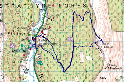
Sgiath a’Chaise and Beinn Earn (NN583169, 644m & NN601158, 813m)

Friday 19 April
Start Point: Community car park in Strathyre
End Point: Layby by Ardchullarie More
Distance and Ascent: 11.9km, 1000m
Weather: Some sun, some rain, some hail, some snow. Mega windchill higher up.

My route. There was no need to go such a long way around to reach the forest track (see Mick’s route below).

Mick’s route – same outward route as me, but taking a longer route from summit to upper forest road, then shorter way from lower forest road to car park.

I gave Mick the choice as to whether he wanted to do the Corbett or the Marilyn with me this morning and to my surprise he opted for the latter. Happily, he didn’t show any interest in doing both, which is what allowed me to do the linear route.

Other than taking a slightly longer route than necessary at the beginning, our progress to the upper forest road was uneventful. I had read reports as to the best way to get from the upper forest road to the summit, but on our way to the track junction at NN573179, we came across this new track at NN 57357 16812:


An engineered track, although a rough, low-quality one.

We couldn’t see how far it extended, but decided it was worth a punt that it would take us either to the top of the forest, or near enough as to make any subsequent bashing worthwhile compared with the much longer route I’d intended to take when we set out (the route Mick took on the way back – see map snippets above).


There’s more than one new track up here…


…complete with new bridges

It was steep in places, but steep on a track is relatively painless (versus, say, through knee-high tussocks), and our decision to go that way was borne out as we got higher, crested a rise, and could see that the track did indeed continue.

It came to an end at NN 57967 16922, just before we got out of the forest, but there was only one slightly dodgy manoeuvre required on our chosen line up the edge of the unharvested area, then up between two crags. The downside of this route was that it didn’t conveniently land us at a gate in the deer fence.


Summit selfie

Mick came with me a short distance beyond the summit, so that he could see where I was going next, then once I’d rummaged around in my bag for my waterproof (for warmth, although a shower was seen approaching; it turned out to be hail/snow), Mick turned back and I continued on.

The descent was steep but doable, and at the bottom I had a choice: to continue down the glen for 750m to pick up the baggers’ path to the Corbett of Beinn Each, or to just attack the hillside ahead of me. I could see what looked like a good line ahead, so opted not to do the longer distance. Looking at the map again now, had I been making that decision based on the map alone (e.g. in poorer visibility, without being able to see what lay ahead) I wouldn’t have gone that way, as I have a general rule that if there are only two intermediate contour lines shown between the 50m contours for more than 100m, then it’s too steep. As it went, the terrain was firm, cropped grass so whilst steep, the going was easy. I intercepted the baggers’ path at an altitude of around 570m.

By 700m I couldn’t help but notice not just the strength of the wind, but also the chill that it bore. Pausing to send Mick a message once my phone signal returned, I estimated the windchill to be around -10. I later looked up the MWIS forecast, and that’s exactly what it predicted. Whilst it was only my hands that got cold (or never warmed up; they were cold when we set out), even with the steep ascents, the first time I felt truly warm on this outing was when I descended back below the 300m contour (I had on a long-sleeved baselayer, a windshirt and my waterproof, plus a buff and buffalo mitts).


Another summit selfie

There was clearly another Marilyn over there (Munro too, as it turned out when I looked at the map later), but I wasn’t in a position to nip over to it today.

As I left the summit I messaged* Mick with an ETA of 1255 at the layby where he was meeting me. I arrived at 1256, which wasn’t bad, I thought, considering I’d taken a small accidental detour in the final kilometre (missed a turn) and then encountered a few blow-downs across the path.

An excellent morning out and encouraging that I felt good the whole time. 

(*I discovered yesterday that my phone has lost the ability to make phone calls. It occurred to me today that could be a problem should I find myself in a pickle. It’s still letting me text and WhatsApp.)

Beinn na t-Sidhein (NN 547 178; 572m)

18 April 2024

Start Point: Community car park Strathyre
Distance and ascent: 6.6km, 560m
Weather: light rain the whole way up and half way down, but with some sunshine too (even whilst being rained on). Blowy higher up.
 
Not quite my first hill since last September. I went up Black Hill from Crowden a week and a half ago*, but as I've been up there more than once before, it didn't get a blog post. Today was my first new hill in over seven months**. I'd like to say that I chose it carefully, but the reality was that after spending most of the journey north learning how to use QGIS software to accomplish a task related to the TGO Challenge, we were in Scotland before I had the chance to look at hill-bagging.co.uk and chose a hill for this afternoon. 

The glorious sunshine to which we had awoken near Shap gave way to continuous rain soon after entering Scotland, and it stayed with us all the way to the parking area. It was still going as I stepped out of Bertie, but the forecast was optimistic that it would become showery as the afternoon went on, so I was optimistic too.

It rained on me the whole way up - an ascent that involved a small side-trip to a subsidiary summit. Looking at a map occasionally is always a good idea on these outings (an omission made even worse as I had the route on my watch, so just a glance at my wrist would have told me I was going awry). 

There are two summits on this hill: the official one and another that is of equal height. I visited them both. I'm sure I could then have continued north off the summit and found a way back into the forest to gain the forest track to loop back around, but I didn't think about that at the time. Besides which, the weather was a touch on the wild side up there, so retracing my steps back along a trodden line was the easy option.

Having suffered a lack of energy and stamina this year, it was unexpected to have achieved the ascent without feeling much effort and to get back to the Bertie feeling absolutely fine. Hopefully I'll still be feeling good in the morning for another hill (or two?) just across the road.


Viewpoint on the way up 
Summit selfie


(*Conrad: I'm pleased to say that we kept up our record of always meeting at least one person doing the whole Pennine Way when we're out for a little jaunt along it. This chap was on day 2, had started during the tail end of Storm Kathleen, and was not having a good time. Given that the weather was pretty grim again the following day, I wouldn't be surprised if he called it a day to return in a better weather window.
**I did have two months of inactivity due to surgery, followed by a further period of gently rebuilding fitness, but it's possible I wouldn't have been up any hills in that period anyway. What I would have done, without the enforced lay off, is have maintained my fitness to a much higher degree.)