The Road goes ever on and on; Down from the door where it began;
Now far ahead the Road has gone; And I must follow, if I can;
Pursuing it with eager feet; Until it joins some larger way;
Where many paths and errands met; And whither then? I cannot say.

[JRR Tolkien, Lord of the Rings]

Tuesday, 23 August 2011

East to West Photos: Day 9

28 March (0900-1530)
Distance: 14.5 miles (Tot: 161.5) (Boston to Tattershall)
Weather: high cloud, sunny intervals, warm

It was another misty start to the day, but it was burning off nicely by the time this first photo was taken. When, at this point in the morning, I finally turned around and looked at where we had come from, I wished I had turned earlier. The tower of the church was once again striking, being so huge and so nicely placed in line with the waterway.

 Day 7-1 The waterway is the River Witham, but being contained between man-made banks, running in straight lines and having no appreciable flow, it has the appearance of a large canal more than a river. Indeed, it even featured narrow boats, as well as cabin cruisers. This craft looked like it had seen better days…

Day 7-2 With the mirror-calm surface and the mainly-blue skies, it all looked very pretty.

Day 7-3 We headed away from the river and into Tattershall, where I was torn as to whether it was worth a whistle-stop tour of the castle (doesn’t it look fantastic?), or whether my time was going to be better spent laundering our clothes. Alas, the mundane chores won the toss and so we headed straight to the campsite, but we really must return to visit the castle.

Day 7-4

Actually, we didn’t quite go directly to the campsite, as we paused for an ice-cream on the way, but I was so busy eating the ice-cream that I didn’t take the trouble to photograph either the kitten who wanted to be my best friend, nor the iguana sitting on the shoulder of the girl on the bench opposite.

The original blog post for the day can be found here.

Monday, 22 August 2011

East to West Photos: Day 8

27 March (0810-1445)
Distance: 17 miles (Tot: 147 miles) (N of Holbeach St Matthew to Boston)
Weather: cloudy, couple of minutes of vague sunniness

I have no idea why so few photos were taken on this day. Maybe we just thought that we had enough photos of flat land and sea defences?

The camera certainly came out when a pack of horses followed us across a field. They were quite inquisitive and didn’t stop to consider us from a polite distance.

Day 6-1Having left the broad, modern sea defence, which is alongside the sea, we took to an old defence that was further inland. It wasn’t the same smooth, easy walking as the more modern version, but certainly had boasted more variety in surroundings.

Day 6-2Port Boston gave some interest as we walked along The Haven on the way into the town (I was particularly taken with the scale of the scrap yard at one of the docks), but the town itself only seemed to have one notable feature: that huge church tower.

Wikipedia tells me that St Botolphs is the largest parish church in England. It was certainly both striking and visible for a long way!

Day 6-3

The original blog post for the day is here.

Sunday, 21 August 2011

East to West Photos: Day 7

26 March (0730-1700)
Distance: 22.5 miles (Tot: 130 miles) (Admiralty Point to N of Holbeach St Matthew)
Weather: cloud, two light showers, a chilling wind

I’m not sure why there aren’t more photos of this day, as we made our way around The Wash, via Sutton Bridge, to Holbeach St Matthew. I do recall that it was the coldest I got on the entire trip, so maybe that was why I didn’t get the camera out more.

Similar to the end of Day 6, most of this day was spent walking along sea defences, where on the seaward side were salt marshes and a sea view. The lumps in the photo below are two man-made islands; the second one in particular was deceptive in its position and seemed to be just ahead of us for hours upon hours, making us feel like we were making slow progress.Day 5-5 

About 150 yards away from the lighthouse in the photo below, directly across the River Nene, was another, matching, white lighthouse. There being not a bridge between them, we had to walk 6.5 miles to get to the one on the other side. On the plus side, we did get to see some of the industry on the river, and to meet an interesting family in Sutton Bridge when we gate-crashed their closed pub for a cup of tea.Day 5-1

There are no photos of the next 15 miles, even though my memory tells me that there were things that should have been photographed. Fifteen miles later, we were on the lookout for somewhere to pitch and were more than happy to find a perfectly flat area next to a pumping station and with the benefit of the camouflage of the green palings (funny to think that we were hiding behind gappy fencing), I was happy to pitch well before dark. As far as we’re aware, no-one passed by whilst we were there. Day 5-2The pitch may look a bit industrial from the photo above, but taken from a different angle it was completely inoffensive rural pitch (and I’m pleased to say that with the low water levels in the drainage channels, the pumping station didn’t suddenly start up during our stay).

Day 5-3

The original post about Day 7 can be found here.

Friday, 19 August 2011

East to West Photos: Day 6


25 March (0730-1740 less lots of time stopped)
Distance: 19 miles (Tot: 107.5) (Pentney to Admiralty Point)
Weather: hazy sunshine, some cloud, thankfully not so hot!

It had been pitch dark when we returned to the tent the previous night, after an excellent meal and a fantastic evening courtesy of Sally & Geoff. Geoff wasn’t put off by our early start and so by quarter past seven, when we emerged from the tent in the chill of morning, he was already striding towards us. He kept us company as we walked (mainly) alongside the River Nar, until just before King’s Lynn where he headed off to head back south as we continued north. Here are Mick and Geoff walking together:

Day 4-1

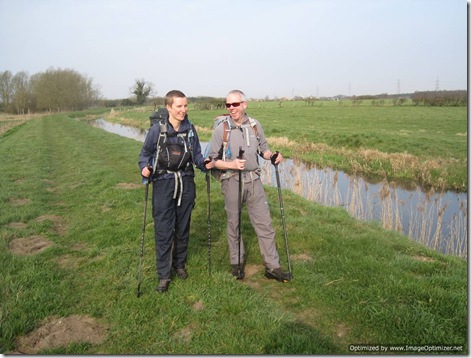
It seemed a bit curious, having a waterwheel with no other obvious structure nearby. Day 4-2Geoff kindly offered to take a quick snap of us. It’s unusual to get the two of us together in a photo when it’s not an obviously-posed self-timer (or Stic-pic) job.
Day 4-3 The morning haze had burnt off and it was another gorgeous day as we continued along the water:

Day 4-4 It wasn’t all lovely. This was a strewn heap of mixed household rubbish, which had been driven a distance along the embankment from the nearest road. Why, oh why?

Day 4-5 We spent hours in King’s Lynn (where I failed to take any photos) before catching the ferry across the River Great Ouse. I didn’t take a photo of the ferry either, but here’s the river, approximately where the ferry crosses:

Day 4-6 Our path went directly underneath this:

Day 4-7By this time we were walking along the west bank of the River Great Ouse, which had a completely different feel from the earlier walk along the River Nar.

Day 4-8 We took our time finding a pitch near to Admiralty Point. Houses are few and far between in this area, but as it’s all so flat it can be difficult to get completely out of sight (unless you drop down onto the salt marsh on the seaward side of the sea defence, which didn’t appeal as an option). Added to the open flatness, it’s a nature reserve, so we really needed to be extra-discrete and ensure that we couldn’t be accused of causing any undue disturbance to the reserve. What you can’t see from this photo is that we’re on the perimeter of a cropped field, hidden in the corner where two sea-defences meet. As indicated by the photo, we didn’t pitch until sun-down, but even then a late dog walker came by. We were in fear of being moved on, but “Lovely evening!” was her only reaction to finding us camped there.Day 4-9

Thanks the wonders of technology (and thanks to Conrad who did the technology bit and provided the improved version) here's a lighter version of the above photo:

The original blog post for the day (which I’m typing in that photo above) can be found here.

Thursday, 18 August 2011

East to West Photos: Day 5

24 March (0710-1615)
Distance: 22.25 miles (tot: 88.5) (Swanton Morley to Pentney)
Weather: wall-to-wall sunshine

Day 5 was ridiculously hot for the time of year, and also quite long. It hadn’t started hot, mind. In fact, it was so cold in the night that, when I got up in the morning and visited the heated toilet block, I had to wonder why (as we were the only people on the site) we hadn’t just slept in there.

This was the start of the super-hot day:

 Day 3-5

The mist soon burnt off.

My only memory of my previous trip into this part of the country (in 1981) was of one of these structures on a village green. We took advantage of the benches in this one for a quick break. I was hot and bothered and my feet were protesting, and we still had a long way to go.

Day 3-6

There were some very pretty properties to distract us along the way:

Day 3-7

If it hadn’t been for the length of the day, then we would have spent longer investigating the remains of the castle at Castle Acre. As it was we still took the time for a quick look around, before hotfooting it to the nearest pub to rehydrate and refuel.

Day 3-8

Soon after the pub, the old Priory looked worthy of investigation too, but after a quick snap we moved on.

 Day 3-9

With 21.5 miles down I think this photo says a lot about how much I was struggling with the distance and the heat of the day. Happily it only took a couple more days before my body got used to the daily assaults and stopped protesting.

Day 3-10

The original posting for the day can be found here.

Wednesday, 17 August 2011

East to West Photos: Day 4

23 March (0736-1450)
Distance: 15.5 miles (New Hainford to Swanton Morley)
Weather: wall-to-wall sunshine

Having taken our life into our hands by following an A road for a mile, back onto farm land we went. There were some massive fields! (And another gorgeous blue sky, which explained the ice on the tent again.)

Day 3-1A disused railway line gave easy, traffic free walking, and for once it hadn’t been given a tarmacked surface. The downside of the lovely dirt surface was that I didn’t hear the runner approaching until he was immediately alongside me. I jumped almost as high as those trees.

Day 3-2 One of the many bodies of water at Lenwade, once again set off nicely by the colour of the sky.

Day 3-3

Thanks to the plethora of permissive paths around Norfolk, we were able to take a short-cut to our  night-stop, where we were the only camping residents that night. It was warm enough when we arrived to sit out and get everything aired. In fact, having hand washed our clothes, I also got most of them dry in the late afternoon sunshine. The sky was indicating that it was going to be another cool night, though.Day 3-4

The original blog post for the day can be found here.

Tuesday, 16 August 2011

East to West Photos: Day 3

22 March (0740-1515)
Distance: 16 miles (tot: 51 miles) (South Walsham to New Hainford)
Weather: AM: wall-to-wall sun; PM: cloud

It was an absolutely gorgeous morning (as illustrated by the photos below), and it was still quite early when we passed through the village of Ranworth. I was intrigued by the fact that almost every house in the village was thatched, even though most of them weren’t ‘thatched cottage’ sorts of properties. Some looked to be pretty modern (in the context of UK property), which looked a bit odd with a thatched lid:

IMG_2131 IMG_2130

Down the hill from these houses was Ranworth Broad, of which we both failed to take a good photo, but here’s a rough idea of how it looked.Day 2-1

If my memory is correct, then this pub (which had come recommended) was in Woodbastwick. It did look like a good place to tarry, particularly on a sunny day, but being only 0930 when we passed by it was a bit early for opening time.

Day 2-2

Why just say ‘please shut the gate’ when you can be much more colloquially poetic about it? Day 2-3

Arriving at our campsite for the night we had to hang around for a while before we managed to get hold of the owners to find out if we could camp (a sudden crisis of confidence on my part as to whether they did take tents), during which time the horses in the next field took great interest in us. Two of them had got bored by the time Mick took this snap:

IMG_0163

The original blog post for Day 3 can be found here.

Monday, 15 August 2011

East to West Photos: Day 2

21 March (0815-1440)
Distance: 15 miles (Tot: 35) (Great Yarmouth to South Walsham)
Weather: fair, some sun

A spot of trespass took us from our brief walk along the Weaver’s Way onto the south bank of River Bure. As it turned out, our passage along the south bank of the River Bure was also trespass, as the Public Right of Way was closed, but we didn’t find that out until eight miles later.

Those eight miles didn’t feature a single foot of ascent or descent as our route took us along the top of the sea-defence, but with the novelty (for me) of windmills, reeds and a few passing water-craft, I was happy.Day 1-6Remembering that we weren’t in a rush, Mick took the time to pause to address three donkeys. They were quite interested in whatever it was that he was telling them:Day 1-7

At Acle many moored craft were passed. We particularly liked the name of this one:

Day 1-8

At the end of the day it felt like the trip had really started. For the first time, we were happily ensconced in the tent (Susie Superlite), with a cup of tea in the making.Day 1-9

The original blog of the day can be seen here.

East to West Photos: Day 1

20 March (0725-1250)
Distance: 17.5 miles (Lowestoft to Great Yarmouth)
Weather: High cloud, some sun

Much of the morning of the first day was spent following the Angles Way through farmland and through/past villages. Somerleyton was the most notable village through which we passed, by the fact that so many of the buildings were worthy of a photo. This one below is of Somerleyton Primary School. What a pretty building in which to be educated! Day 1-1The next notable place we reached was Burgh Castle, but before we got there we passed two lovely little churches:

Day 1-2 Day 1-3Not long after we joined the River Waveney, where we got to really appreciate the flatness of the landscape for the first time, we got to Burgh Castle and thought that it was worth a tiny detour to take a look. There are three walls remaining of this Roman fort, but more notable for us as we approached was the gaggle of twitchers who all seemed to have their scopes/binos trained on us. We never did find out what they were watching.

Day 1-4I’m rather disappointed that I completely failed to get a decent photo of a windmill. There was always more than one within view and we passed close to more than one of them, and yet this is one of the clearest photos I have (which was taken from the lump on which Burgh Castle stands):

Day 1-5After a short jaunt up Breydon Water we finished our walk for the day, before 1pm, in Great Yarmouth. Realising that we had yomped along in ‘training walk’ mode, rather than in the more leisurely style of long distance walking, we made a mental note to slow down on the ensuing days.

The original blog post for the day can be found here.

Sunday, 14 August 2011

East to West Photos Day 0

19 March
Distance: 2.5 miles

Day 0 was the day that we left home and caught a few trains to get us down to Lowestoft. Before we left Mick had neatly laid his kit out for a kit-photo: Day 0-0

Quite a few hours later we arrived in Lowestoft and our first task was to navigate our way from the railway station to Lowestoft Ness. The route between the two isn’t the prettiest, leading through an industrial area, but at least the brown sign confirmed that I hadn’t led us astray before we even reached the start line! Day 0-1

It’s obvious when you’ve reached Lowestoft Ness; there’s a big topograph feature on the pavement telling you that you’re there, and also giving the linear distance to a number of other key locations on the British mainland.

“Lowestoft – Britain’s most easterly point” – that seemed like a good start on an East to West walk!Day 0-7

Land’s End. Been there!

Day 0-2

Lizard – that’s to where we walked first when we left Land’s End in 2008:

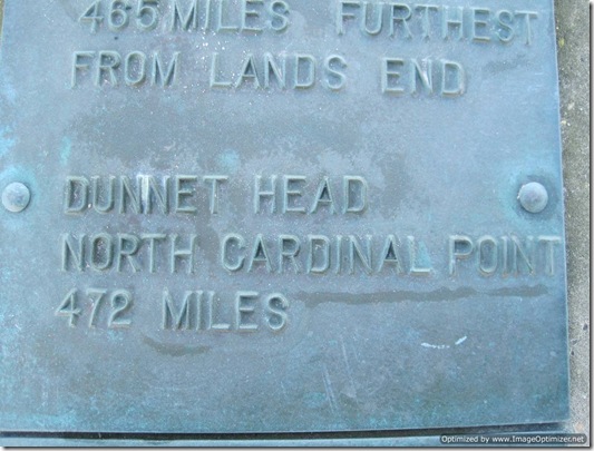
Day 0-3 Eighty-one days after we left Lizard Point we arrived at Dunnet Head. Day 0-6

And, of course, our first Biggie finished at John O’Groats (actually, that’s not true; it finished at Duncansby Head, but either Duncansby Head wasn’t on the Lowestoft topograph, or I didn’t take a photo of it)

Day 0-5

I’m also assuming, by the lack of a photo, that the topograph didn’t include the most south-easterly or the most north westerly points.

Here’s one to which we hadn’t walked, but if all went well on this walk it was the point that would complete our ‘British Extremities’ series of walks.Day 0-4

And here we are taking a self-photo at the most easterly point. I don’t know how Mick was only wearing a fleece – it was absolutely freezing!

Day 0-8

There are no more photos of Day 0 because it was only 2.5 miles long, mainly followed the sea-front, and finished at the Travelodge.

Day 1 was more interesting…