The Road goes ever on and on; Down from the door where it began;
Now far ahead the Road has gone; And I must follow, if I can;
Pursuing it with eager feet; Until it joins some larger way;
Where many paths and errands met; And whither then? I cannot say.

[JRR Tolkien, Lord of the Rings]

Sunday, 28 April 2013

Two Journeys to Follow

I do like following a blog of someone who is on a long journey, and two of my favourite bloggers are currently obliging me by setting off on new adventures. If you’re partial to following a journey yourself (which I assume you are, if you’re reading this blog!), then I would recommend that you take a look at what they’re up to.

First off there’s Erin (who goes by the trail name ‘Wired’), who in her quest to do the Triple Crown, has just set out on the Continental Divide Trail. It was entirely thanks to the inspiration of Erin’s blog that we came to walk 500 miles of the Pacific Crest Trail last year. She thru-hiked the trail in 2011 and wrote such a compelling blog that even though I didn’t come across it until she was approaching half way through, I went back and read right from the beginning. By the time she finished, she had me completely sold on going and taking a first hand look at part of what she’d just walked. Aside from writing well and including lots of detail about what she’s experiencing, she includes plenty of photos and, every few weeks she uploads video snippets she has taken too. I can’t think of another blog which gives such a good impression about what the trail, and what thru-hiking, is really like.

Then there’s Sarah Outen, who is in the middle of her ‘London to London: Via the World’ expedition. In 2009 she became the first woman (and the youngest, at 24) to row the Indian Ocean and her blog was a treat to read. Then, in 2011 she set out to circumnavigate the world under her own power. She kayaked across the channel, cycled from France to the east coast of Russia and then kayaked across to Japan. After a break over winter, she set out from Japan last spring to become the first woman to row the North Pacific but came a cropper in a tropical storm that saw her rescued by the Coast Guard. Her boat was lost. She’s obviously not a quitter though (and, equally clearly, must be slightly mad!), and with a new boat she’s been patiently awaiting a suitable weather window to resume her round-the-world adventure. The weather window opened on Saturday and it took her just two attempts to get away from land. Fingers crossed that the weather is kinder to her this time, but it’s certain to be far from a walk in a park (I mean, really, can you imagine rowing across any ocean, never mind the North Pacific?).


Go on, click on their names and take a look!

Saturday, 27 April 2013

Some Thoughts About Our Henry Shires Tarptent Double Rainbow

This isn’t a review. It’s just some thoughts about the tent and why we came to the conclusion that, for us, it’s a ‘tent for situations when you probably don’t need a tent’.

That likely makes it sound as if we don’t think much of this tent, but that’s not true at all. We lived in her for five weeks last year and can’t think of any other accommodation we would have preferred on that trip. We wouldn’t hesitate to use her again for similar trips where cold and wet conditions were expected to be few and far between.

Here she is sitting happily in the desert in California:

IMG_2304

Not fantastically well pitched, but we were on sand in a stiff wind!

That was one of only two occasions in the five weeks we were in California that we spent the night with the porches closed. Usually, we spent the night like in the photo below, with the porch doors tied back, the breeze blowing through and with the dual benefits of night-time views but with full bug protection:

Day 23_7

That was quite a stunning pitch!

The tent is simplicity itself to pitch. You pop the single pole through its sleeve (a job which would be easier if the end of the pole sleeve was offset, so that you can find the opening without having to separate two seams which are lying against each other* – it’s one of two mods that I would like to see Henry Shires introduce), put four pegs in (one in each corner) and adjust the adjusters**. If you’re using the porch, you need two extra pegs. If you want to use guy-lines to stabilise the pole, then you’d need a total of eight pegs all in.

Within two minutes you have a nice spacious shelter ready to use. It’s so quick and simple to pitch that we regularly popped it up at lunchtime to keep the flies off us.

Whilst we loved the tent in California, we were never convinced that it would work for us in the UK. In hot dry weather (moreover in bear country) we never had the need to cook under cover. For the same climatic reasons, we were always able to put our bags inside with us (this is a long tent – the packs happily fitted at the one end of the tent, our bits and pieces at the other end, with the sleep mats in the middle. We also only had a couple of nights when we had a modicum of condensation.

Our concerns for UK use were:

  • Would wet packs fit in the porches without encroaching on the inner?
  • With the packs out in the porches, would there be enough room to cook comfortably?
  • Even without the bags, would there be enough room to cook in a porch?
  • With so much mesh on the tent (particularly the two strips along the bottom of the short ends), would we get water ingress in wet and windy weather?
  • With so much mesh, would it be too cold?

Our trip out to Bleaklow last night turned out to be ideal conditions to explore our concerns. We didn’t get the rain we were looking for, but snow was an excellent substitute. There was certainly quite a good breeze blowing.

IMG_5257

The morning of 27 April, on Bleaklow

What we found out was:

  • On the positive side, our finding in California was borne out again, that she doesn’t flap unduly in the wind.
  • The mesh combined with the large gap between flysheet and ground (unsurprisingly) led to a very draughty and cold night. Mick found that he couldn’t lie facing his door as the wind in his face was too great. We both prefer a higher degree of draught exclusion.
  • The porches aren’t high or deep enough for me to be comfortable with cooking in them  – particularly on a less than flat pitch where I need to fish around in the porch for somewhere flat enough for the stove.
  • When the fabric slackens in the wet, and when it’s so cold out that you can’t be moved to go and do something about it, and if the wind then swings around, the porch fabric can be pushed against the mesh side of the inner tent, transferring moisture through.
  • When it’s snowing, there’s lots of scope for snow to make it through the vents in the fly and then through the mesh of the inner.
  • It’s just not as comfortable for us as our Terra Nova Voyagers.

We didn’t explore the use of the ‘storm flaps’ which are designed to allow you to get in and out of the tent in the rain without the inner getting wet. We had enough information to inform our decision without doing that.

So, even though the Double Rainbow has the huge attraction of weighing a smidge under 1350g, in a situation when we’re going to want to spend waking hours inside of the tent, and to cook under cover, I’d rather take the weight penalty of the Voyager.


*I’m not sure that I’ve explained myself particularly well there, but I know what I mean even if you don’t!

** If this was a review, I would put lots of photos in to illustrate what I mean when I say ‘adjust the adjusters’ or ‘the mesh at the bottom of the fly on the short end’, so it’s a good job this isn’t a review.

(There are lots more observations I could make, but I’ve wittered on enough for one post. If anyone has any particular questions about our experience of the Double Rainbow, feel free to pose them to us.)

A Tent Testing Outing

“If my pack could be this light for the Challenge, I’d be quite happy” I said as we left the car and set out through Old Glossop to head up Doctor’s Gate. I was skipping along with a pack which weighed almost nothing.

It was about fifteen minutes later, just as my hands were getting cold, that I learnt one of the reasons as to why my pack was quite so light. It was because a key stuff-sack, containing three pairs of gloves, a hat, a buff and my waterproof socks, was still sitting on the carpet in the spare room, right next to where I had packed my bag. Doh!

We paused and considered the situation for a few moments, but I declared that I would manage with just my spare socks for mittens. In due course, Mick (being the lovely gentleman he is) insisted that I could use his gloves. Unfortunately, it transpired that his second pair of gloves had suffered a similar fate to all of mine, so he was left to freeze his fingers off.

There’s not much to say about our route. We’ve played in this area sufficiently now to know where we were going without needing to engage our brains, so up to meet the Pennine Way we went, thence to Bleaklow.

By and by, past lots of greeness where bare peat used to be, Bleaklow Head was reached. Mick broke out the camera and snapped me there…

IMG_5242

…just a moment before I broke the news that our lack of brain engagement had gone a little too far, as we were meant to have turned a few minutes before.

A bit of a yomp was chosen rather than a back-track, and on the way we stumbled across this:

IMG_5243

Mick had also lent me his buff by this point. Fortunately, I had the peaked cap on my head as we left the house.

That’s the third time we have stumbled upon a geocache without even knowing it was there. I say ‘stumbled upon’, but we had actually passed this one by, and were both looking behind us when we spotted what looked like a cache hiding place – and so it was.

The yomp through heather was declared to be good Challenge training and after twenty minutes we got to where it was that I wanted us to be – a feat we completed via old-fashioned methods, as we learnt on the way that Mick’s iPhone has deleted all of our 1:50k maps. Glad we found that out now rather than in a couple of weeks time!

That wasn’t the end of the day, however, as first we made an absolute meal over finding a pitch. To be fair, it wasn’t that we were being particularly picky in our choice, it was more that we couldn’t find any lump-free, level ground that was free from heather. I couldn’t even locate the pitch I’d used in the same area previously.

Up and down the same path we went, pondering whether to head all the way back up to some lovely pitches we’d seen quite a while before, but in the end we settled for something that would do:

IMG_5246

It was about exposed as you could ask for (exposed was as key part of our tent-testing experiment) and within minutes of pitching quite a hail shower came through (that’s why there’s a white mark around the footprint of the tent). Within minutes we had also come to the firm consensus that this was not the tent which would be Challenging with us this year.

We could have packed up and gone home at that point, as we had fulfilled the purpose of the trip, but as we’ve become far too used to our home comforts (not to mention awfully nesh) over the last nine months, we decided to stay put.

Chores were done, food was cooked and eaten, more chores were done and by 9.30 lights were out.

At about 10pm I said ‘That’s quite heavy’ about the rain that was hitting the tent.

At 10.25pm, I opened an eye, looked at the fly-sheet and thought ‘That’s not right’. What I’d taken to be heavy rain was actually very heavy snow and the tent was sagging under the weight. Banging the sides made it slip down, but it was still sitting heavily against the bottom edges of the porches, so out I went to sort it out and I couldn’t believe how much snow had fallen in just 25 minutes.

Not a lot of sleep was had on my part. I was cold, my feet were blocks of ice, the wind was positively whipping through the tent and another trip outside was called for at 2am.

When we’d set out on this trip, this is not the scene I’d expected to wake up to:

IMG_5257It’s nearly May! And we were only on a little hill in the middle of the country – it’s not like we were on a big hill ooop north!

Our walk out was short and reasonably uneventful. We wanted to be home and showered in time to get over to Wolverhampton by 1pm to meet friends for lunch so an early start and a short walk out were the order of the day. As it turned out we were back in Old Glossop before 9am.

As for the reasons behind our verdict on the tent, I think I’ll leave that for another post.

Sunday, 24 March 2013

And Still It Snowed

My prediction of slush and mud being the prevailing underfoot conditions for today didn’t quite prove to be true, but before I came to discover that we had to stir ourselves to get out of the house. Ready to go by just after 8am we then struggled to motivate ourselves to set out, as a glance out of the window told us that it had snowed some more overnight and that it was still coming down.

IMG_5193

Eventually we had exceeded all previous records for faffing, and out the door we went. It took me fewer than three paces to realise that the expected slush was not going to be an issue. Yesterday’s rutted slush had frozen solid overnight and a fresh layer of snow had fallen on top, forming drifts in the fierce wind.

IMG_5196

Mud proved not to be an issue either. The fresh snow boosted the levels enough that only at the boggiest wallow on our route did we sink through the snow and into the gloop. More of an issue was the deeply furrowed field, with snow filling in the dips. We fumbled and stumbled our way across there, sometimes sinking into a furrow, sometimes hitting the high ground.

IMG_5201

Our route today took us down a lane I’ve not walked down before, which led me to discover a set of permissive paths that I didn’t know were there (there are a lot of National Forest Plantations around here, all of which feature permissive paths, but there doesn’t seem to be any way of finding out where they all are, other than stumbling across them, as we did today). That’s opened up some possibilities for extending my collection of local circuits.

I’ve included three snaps that I took today, even though one of them bears a remarkable resemblance to one I used yesterday. I can never resist a photo of that church.

Saturday, 23 March 2013

Spring is Further Delayed

Yesterday morning’s vague smattering of snow on our lawn had melted by late afternoon – just ready for it to start to snow again. By this morning we had almost as much snow as there was on Cannock Chase yesterday. I imagine that there was quite a bit more on the Chase this morning, but we didn’t venture over there to find out. This time we stayed close to home and set out on one of our local circuits.

IMG_2850

It wasn’t a big circuit at just under 5.5 miles, but the snow made it feel like good exercise.

Back at home before 11am, we were faced with three quarters of the day remaining and nothing to do with it. So, we had an early lunch and then went back out for another (different) circuit, this one lying in the opposite direction to the first.

IMG_2852

By now the falling snow (it really hasn’t stopped the whole day long) was getting wetter and on this circuit the underfoot conditions often featured very soft mud under the snow. Even better ankle-shaping exercise than the morning’s walk.

IMG_2855

The afternoon’s outing was a modest 4 miles long (but with more than 100 feet of ascent, which is as hilly as we get without venturing a few miles further).

I think that we may resort to walking along lanes tomorrow. I’m not sure that I can be doing with the slush/mud combination which, I’m guessing, will prevail tomorrow.

Friday, 22 March 2013

Abort! Abort!

With just the tiniest smattering of snow adorning our lawn this morning, we only gave a cursory thought to changing our plan for the day before setting of for Cannock Chase.

The roads got a bit snowier and quite slippery as we approached the Chase and as I drove into the car park I asked Mick whether he thought this was wise. “No!” was not the reassuring answer for which I was hoping.

We weren’t concerned about the underfoot conditions. Our concern was purely about getting back out of the car park and, if it snowed some more whilst we were out, getting back home in one piece (about 50 yards down the road we could see a car which had just slipped off the road as it negotiated a bend).

However, it wasn’t snowing just then and we’d taken the trouble to drive over there, so we decided that we may as well take a very short stroll before heading back home.

IMG_2831

I could be wrong, but this might have been the first time that we’ve ever been out on the Chase and not encountered a single other person. We did see a couple of sets of foot prints.

At the rifle range (that’s where I’m nearly up to my knees in the snap below), we took a little out-and-back detour, unsuccessfully looking for the half-a-surf-board that we’d seen abandoned there last weekend. Had we found it (a white object underneath lots of white snow was never going to be the easiest thing to find!) we would have indulged in a bit of ‘tobogganing’ before carrying it off with us for proper disposal. As it went, we had to make do with a snow-ball fight.

IMG_2832

Wishing I’d put my gaiters on, as the snow got into my boots…

Just two miles were walked. Not the nine we were hoping for, but we’ll focus on the fact that walking two miles (moreover two miles in snow) is better than walking no miles at all.

IMG_2835

Sunday, 17 March 2013

A Wee Rantette

Would you believe that today was the first time that we’ve set foot on Cannock Chase since January 2012?

Would you also believe that, on a Sunday morning, we were parked and walking by quarter past eight?

I find both facts quite hard to believe.

Only a few things were notably different from our previous visits, the main one being the amount of litter. Why, oh why? If you can carry a plastic bottle full of drink onto the Chase, surely you can carry the few grams of plastic bottle back off again? If you can carry a snack bar onto the Chase, surely you can carry the wrapper back off again? If you can carry your M&S tray of sushi onto the Chase, surely the crook of a multi-trunked tree isn’t the right place to put the empty plastic tray?

Who do these oiks think are going to clear up after them? What do they think is going to happen to their litter? Who do they think is going to pick up after them? Or do they visit beauty spots like this and still say ‘eeee, int this grand?’ even with the litter?

rubbish

As you’ll notice if you look at the background, this load of rubbish is right next to a car park. The oiks thought this state of affairs was the better option than carrying their litter fifty paces back to the car with them.

We very rarely come back from a trip on the Chase without a plastic bottle or two. Today we broke our previous record and picked up seven (there’s an orange Fruit Shoot one hiding behind the Coke one).  Depressingly, directly on our route, we left as many bottles as we picked up.

7 Bottles

I imagine that the rigid sports bottle on the left was an accidental loss, particularly as it was still half full.

In one area we passed an entire trail of very recently discarded ‘Chewy Bar’ wrappers. The only people we saw on that section of the Chase were group after group of Scouts doing D of E training. Not that I’m implying that there’s any link between those two statements…

And, whilst I’m ranting, there was one other thing I noticed whilst we were walking: the continued growth of the number of signs littering the verges of the main paths. The one on the left in the photo below particularly struck me. The post on the right has been there for a few years, however, someone seems to have decided that the ‘Road Crossing Ahead’ warning wasn’t big enough – not even when you take into consideration that barriers have been placed as obstacles further to alert people to the presence of the road. So, a whole new post has been added, next to the old one, duplicating the message, but bigger. Surely one post would be sufficient? 

Unnecessary excess signage

In spite of the rants (and the tragedy of Mick accidentally knocking over my full flask of tea, whilst I had the lid off it), we had a good march around our trusty old route, racking up 8.5 miles on this occasion (I call it our trusty old route, but the end has a number of variations to give distances of between 7.5 and 12.5 miles). We amassed more up than usual too, having left the main path at one point to go over (what I call) the ‘lumpy-lumpy bits’.

image

Tuesday, 12 March 2013

TGOC Spring Gathering At The Snake Pass Inn

Friday:

Arriving at the Snake Inn early in the afternoon, I wasn’t moved to spend the whole afternoon sitting in the car park looking out at the murk; even with the cold that I’d developed on Thursday, I was up for a bit of a stroll in that murk.

It was just a stroll, though. We didn’t take a map, a compass or, well, anything really. We were just going to wander along the river for a while and then wander back.

Except, that when we got to Fair Brook, I commented that we’d never been up the path which parallels it, so that’s where we headed.

I’m not sure that Mick was entirely enthusiastic about the outing:

IMG_2807

He was just joshing for the photo (I hope, anyway…)

I can’t say that we saw very much, so after a bit of a wander around we headed back down to dedicate some time to reading our books and drinking tea, before hitting the bar for a bit of socialising and some food. Three and a half miles were walked with somewhere in the region of 700 feet of up.

Saturday

image

One of the topics of conversation on Friday night had been how poor the forecast was for the Saturday. It was something to which I had previously been oblivious, having managed to get through the previous week without seeing, hearing or reading a single weather forecast. With the reports I was hearing, I did slightly rue not taking my waterproof set of Paramo…

In spite of the weather forecast, the Saturday walk had proved to be a popular draw and somewhere in the region of 32 people queued up for the stile opposite the Snake Inn:

It takes a while to get 34 people over a stile

There weren’t actually many obstacles on this route, but the first three came in quick succession, with two stiles and the crossing of Fair Brook. Various methods were used for the crossing, from the ‘splosh straight through’ method used by Mick to the ‘I don’t want to risk cold water in my boots today, thank you very much’ approach taken by me.

Soon, another barrier presented itself

After waiting for the group to clear the river crossing, off everyone set again, except for me, as I’d belatedly decided that one of the sheep folds near by deserved a closer inspection. That left me striding up the hill, bringing up the rear of the main group.

IMG_2812

I needn’t have rushed to catch up, as even if there hadn’t been a couple of pauses to regroup, there would have been plenty of time to make up ground whilst the third stile was negotiated. This one was (in common with so many stiles) not only designed for people with eight-foot long legs, but also had a wobbly ‘balance post’ too.

We were in the cloud; it was snowing and cold

The problem with walking in such a big group is that it’s unavoidable that there will be big waits for obstacles to be cleared and for regroupings to take place. On a warm, sunny day such pauses can be a joy, but by the time we reached the edge (Kinder’s north edge, that is) as we were well and truly in the cloud, with snow falling, not to mention that chilled easterly wind. All of those factors were combining to mean that I was struggling to stay warm. Having not felt my toes in the hour and a half or more that we had been walking, when we stopped for a quick sip of tea whilst we regrouped, Mick and I declared an intention to help to reduce the size of the group by continuing on at our own pace.

Martin and Sue (providers of fine cake) and Graham heard our plan and opted to come with us, so off we strode, slowed only by some of the patches of snow which proved to be surprisingly deep and (in unpredictable places) soft:

Snow in the gullies was deep and soft

Our numbers swelled when we stopped for lunch, as Dave and Chris joined us. Our notion that they were the front runners of the big group were declared to be false. Apparently, Dave and Chris were bringing up the rear and somehow the other 25 people had passed us by without any of us seeing them – quite where that happened will remain forever a mystery.

We were soon charging on at a merry pace, finally dropping off the west end of the edge and taking to the flagged path of the Pennine Way. I particularly like this photo of our progress along there:
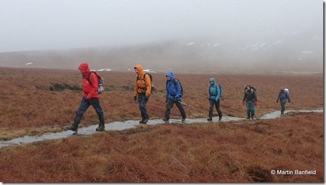
13030930toMoss Castle

My plan at the beginning of the day was that we would cut off down Ashop Clough rather than taking the longer route going via the Pennine Way all the way to the Snake Road, but by the time we got to the path junction I had convinced myself that the extra miles on the Pennine Way and down Lady Clough would be preferable to the wet and boggy conditions in Ashop Clough, so on we went.

I hadn’t been down Lady Clough before and it was incredibly pretty with glimpses, between the trees, of the snow falling and the river running. However, I was becoming desperate for a cup of tea (alas, my flask had long been empty), forcing me to utter those banned words “Are we nearly there yet”. It turned out that we weren’t far away, and at 1630 we wandered back into the car park.

After tea and cake with Martin and Sue in Colin (a statement which will make no sense to anyone not familiar with Colin), we adjourned to the Inn to jostle each other for prime position in front of the fire.

It continued to snow as we sat down for dinner and it continued to snow into the night. As I mentioned at the outset, I hadn’t heard or seen a weather forecast, so the fact that it was snowing at the level of the Inn was as much of a surprise to me as the reports that Saturday was going to be a wet day. I was even more surprised on Sunday when (not insubstantial amounts of) snow persisted so far into our journey home.

Back to Saturday though, and the stats for the day were (according to Martin’s Garmin Gadget, because mine didn’t manage to record our activities, sitting (as it was) in the cupboard in Colin) 12 miles walked with 1500ish feet of ascent.

Just to finish off, here are a couple of photos of the ‘camping area’ on Saturday morning and on Sunday morning. I took both of these photos, but big thanks go to Martin for allowing me to use the ones above, as I only managed to take 3 photos during the whole of Saturday (I had a camera, but with multiple pairs of mitts on my hands it was too much trouble to try to fish it out of my pocket).

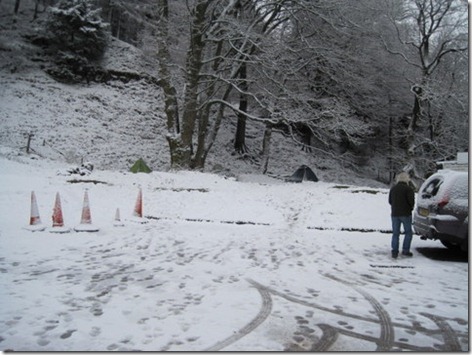
IMG_2808

IMG_2815

Wednesday, 27 February 2013

Scotland - Day 18 (Drumochter)

Anyone paying particularly close attention will have noticed I said that yesterday was our last day of walking for this holiday. That left me feeling a little robbed, as originally we would have had an extra couple of days, but an appointment was forcing us back south a little earlier - a situation which wouldn’t have been so bad if the weather hadn’t been so spectacularly good.

To ease the feeling, last night I started looking at what little lump lay close to the A9, which we could nip up on our way home to enjoy one last dose of snowy views. It was Mick who suggested that I should look at what lay either side of the Drumochter Pass. Genius! Rather that finding a little hill, we could drive up to 1400’, without even leaving our route south, and go up a bigger hill!

Geal-Charn was the chosen objective. With the summit being just 2.5 miles away from the parking area, with 1600’ of ascent, it was the perfect objective which would still allow us to get to Ma-in-Law’s house in time for tea (albeit a slightly delayed tea from when she might have wanted to serve it).

The only slight fly in the ointment was that we didn’t have a map for that area, but with there being no possibility of the weather deteriorating, during our outing, from the clear blue skies which have prevailed over the last few days, I didn’t feel too bad about breaking the cardinal rule of ‘take a map, a compass and know how to use them’.

A group of five from Belfast set out at the same time as us, and for a while we walked along with one of them, until he realised that he had left his companions behind. Being on a schedule, we didn’t pause with him, but positively charged up the hillside (showing a degree of fitness which was certainly lacking three weeks ago) pausing only to don Microspikes when the slipperiness started slowing us down.

IMG_5183

Snow-free on the summit, unlike the ascent route

Within an hour and a half of setting out we were tucking into our flasks and sandwiches on the summit, and drinking in the views. The views were slightly curtailed compared to yesterday, with a haze in the distance,but it was as windless and as sunny as the last few days have been. Gorgeous!

IMG_5180

Downhill was, understandably, faster than up, which was a good thing as if we had been any later we wouldn’t have made it in time for that all-important roast dinner.

As it went, even after getting stuck behind the slowest-lorry-in-the-whole-world-ever, we did make it in time for that roast. And, with the location of said roast being in Yorkshire, I think I can now safely say that our Scotland trip is over and there will be no walking up a snowy hill tomorrow. Only two and a bit months until the TGO Challenge though!

Tuesday, 26 February 2013

Scotland - Day 17 (Aviemore)

Our last day of walking today and the original plan for the day with the best forecast (which happened to be today) was to go up Ben Macdui. After a bit more thought, we tempered our plans to the much shorter outing from Coire Cas car park up to the top of Cairn Gorm and back. The route we took is below, and we went anti-clockwise (given there are arrows on the track, I probably didn’t need to clarify that, did I?):

image

Anyone familiar with the ascent route that we took will probably notice that we started it in a bit of a non-standard way. Merrily we followed the path out of the car park without really paying attention to where we were going, until eventually I came to notice that we were gently skirting, rather than climbing up a spur.

We put that right by simply heading straight up the hill, which put us nicely where we wanted to be.

Having made a bit of an effort to get out of bed at a reasonable time today (Mick did grumble a bit at the 6.30 alarm!) we were up on the steep bit of the spur before we’ve usually even got our sandwiches made, which meant that the snow was still frozen solid, which (in turn) gave us a good excuse to don crampons (something which doesn’t happen very often as Microspikes so often do the job).

It’s steep heading up there, but otherwise easy going, particularly as I wavered around all over the place (zoomed in on the full-sized version of the recorded track you can see the line wobbling around). We were definitely in the minority; the chap ahead of us and the couple behind us were all on skis.

IMG_2801

The views from the big cairn at the top of that ridge were stupendous, and we were so eager to see what it was like on the top that we didn’t pause there for tea or cake (admittedly both had featured earlier on). Up to the top of Cairn Gorm we headed, and what should we find there (aside from lots of skiers), but people dressed in jeans and street shoes! Nowt like a funicular railway to give inappropriately dressed people access to very big hills (although, in fairness, it was so warm and lovely up there today that there was nothing inappropriate about wearing jeans).

IMG_5166

We tarried on top for a long while enjoying the views, dealing with the rumbling tummies and enjoying the views some more.

IMG_2804

As the recorded track shows, we detoured over to the east edge of the summit, just to see the view from there. The snap above is looking back to the weather station. All the black dots are people.

IMG_5165

Looking SW from the summit. The best of a bad bunch of photos which completely fail to convey the outstanding views.

The crampons weren’t needed for the downward leg to the Ptarmigan Hut, but it was as easy to leave them on as to remove them. Remove them we did, when we got to the hut, only then to find that our way the other side was a big sheet of ice. We managed about a hundred yards before the spikes came out.

The way down follows ski runs from much of its length, so we got some entertainment as we went. It’s just a shame we didn’t have the camera out and switched on when a Tornado (the plane, not the weather phenomenon) came roaring low up the valley and over the top of the Ptarmigan Hut. That would have been quite a spectacular snap.

Contrary to how our track appears on the map, we didn’t lose the path as we returned to Coire Cas. It was mainly free from snow by then and it’s such an obvious constructed-path that there could be no doubt that we were on it. It’s another example of the path having been moved from the line shown on the map.

It was only a little outing on the grand scale of things, at just a tiny bit over 5 miles with a couple of thousand feet of ascent. It took us just under 5 hours, although I think that if we had the breakdown of the stats we would find that around half of that was spent sitting down, admiring our surroundings (sometimes scoffing sandwiches/cake/chocolate at the same time).

An excellent, highly-enjoyable, little outing it was, with the icing on an already-very-nice cake being that we finally saw a herd of reindeer. When we pulled into the (then very quiet) car park this morning, there they were, right in front of us.

Monday, 25 February 2013

Scotland - Day 16 (Aviemore)

As today’s weather forecast wasn’t as good as tomorrow’s, our route choice for today was a couple of little hills, rather than a big hill. I’m not sure how tomorrow’s weather could possibly be better – you can’t improve on perfection!

There being a forest lying between us and our objective for the day, we first had to negotiate it. The plan saw us almost exclusively along forestry roads, but reality varied a tiny bit as, not far in, we came across a path that looked like it couldn’t go anywhere except for in our direction, so we followed it. It not only went in our direction but cut off a smidge of distance too.

The tracks got more interesting (i.e. older and less well used) as we went on, until, at the edge of the reindeer enclosure (in which we saw no reindeer, even though we were within it for quite a while), we ran out of track and started following a path.

When the path disappeared under increasingly large patches of hard, steep snow, the spikes were called into action and a direct line was taken. It must have been a sensible line, as when we got to the top of the bank and beyond the snow, we weren’t many paces away from the continuation of the path.

Elevenses were had (even though it was already gone noon), just below Airgiod-Meall, looking at this view:IMG_2776

Whilst sitting there serious contemplation was given to going over the top of Airgiod-Meall. It seemed wrong to be descending into the gap to the south of the hill when we could just go over the top, but after consideration we decided to stick with the original plan. It was a good plan, as the gap is attractive in and of itself:

IMG_2778

‘Twas a bit nippy in the middle though, beyond the reach of the February sun:

IMG_2779

At the other end of the gap we were faced with the side of Castle Hill (complete with lots more patches of snow, far more than we encountered on yesterday’s excursion). In the absence of a path there was no reason to faff around, so straight up we went. What incredible views there were to be had. Notably, behind us we could see the ridge along which we had walked yesterday. Oh, to have had today’s weather yesterday!

IMG_2781

From Castle Hill it wasn’t more than a few hundred paces over to our highest top of the day Creag a Chalamain where the views were outstanding. Unfortunately, because I took a video snippet up there, I forgot to take many photos, but here’s one with the entrance to the Lairig Ghru on the left side and Braeriach dominating the view:

IMG_2784

The spikes were called into action again on part of our descent, as we made our way down to the path which heads through the Lairig Ghru. That wasn’t our direction though; we were heading back north, for miles and miles and miles through the forest. That’s what it felt like anyway. By the time we sat down for afternoon tea (sadly lacking in any kind of cake or snack today, having already depleted our supplies) I really wanted to be tele-transported back to Colin.

Alas, in the absence of tele-transportation, I had to walk, but I did opt not to take the scenic route around the south side of Loch Morlich. Instead the track which runs parallel to the road sped us back to a mug of hot chocolate and a snack. My eagerness to sit down didn’t stop me from nipping over to the water’s edge for one last snap of Cairngorm and its neighbours:

IMG_2795

I was surprisingly tired, feeling like I’d walked twice the distance we had (just over 11 miles was the final tally with just over 2000’ of ascent). This is the track recorded by the Garmin Gadget:

image

(Sorry about the quality of today’s photos – I’ve degraded them more than usual in an effort to help with the upload time. There’s only so long I can sit balancing the laptop in the position it needs to be in order to get a 3g connection!)

Sunday, 24 February 2013

Scotland - Day 15 (Aviemore)

We didn’t get the sunshine I wanted and expected for today’s outing. In fact, quite the contrary: it was snowing convincingly as we set out, but it was just one of a number of flurries which passed through today.

The weather, and the low cloud made me think that we should save our intended route for a nicer day, but Mick was set on it, so out towards Ryvoan we headed.

The snow on the track looked pretty as we made our way up through the woodland, but it really was only the slightest of dustings:

IMG_5137

By the time we reached Ryvoan Bothy it was feeling like elevenses were well overdue, so we popped in for tea and cake…

IMG_5140

Taking a snap of the bothy was something of an afterthought.

…before heading up and up on a veritable motorway of a path which wasn’t where our map said that it should be. Our paper map is six years old now and from the (rather newer) electronic map shown at the bottom of this post it’s apparent that at some point in recent years the path has been re-routed. With us going up and the cloud coming down, we found ourselves shrouded earlier than we would have liked, but after a while spent lunching in the lee of the summit cairn, some of the cloud drifted away again:

IMG_5145

The top of Meall a Bhuachaille

By the time we got up to leave, it was even clearer still to the east (i.e. behind Mick in the snap below), but the continuation of the ridge, to the west, was still hidden behind the cloud. I said that there was just no point in walking the entire ridge if we weren’t going to be able to see anything and thought that we were going to have an early descent.

IMG_5147

However, by the time we got to the junction of paths, where we would have headed down, the next top was in full view, and it didn’t look very far away, so we thought that we may as well nip up it:

IMG_5150

It was in cloud by the time we got to the top, but by then it seemed a better idea to continue along the ridge than to retreat back to the downward path. A good decision, as the weather did clear as the day went on.

In fact, by the time we were on our way through the forest, we even got a glimpse of some of the high Cairngorm tops.

The stats for the day were 10.5 miles walked with 2500’ of ascent, throughout which we were happy to find all of the ground and bogs frozen solid. It was evident that parts of the route could be quite soggy and soft underfoot in warmer weather.

image
