Merrick (NX427855; 843m); Kirriereoch Hill (787m); Mullwharchar (692m); Craignaw (645m)

Slightly noisy GPS track, particularly on the way up Merrick. I didn't wander around like that in reality!
Start: Bruce's Stone Car Park, Glen Trool
Distance: 26.1km
Ascent: 1600m
Weather: low cloud until 10.30, then clearing to sunshine by late afternoon
(8.5hrs tot; 7.5 moving)
It took only about a mile of our ascent of Merrick to have us down to our t-shirts this morning, fending off midges as we'd paused in the windless forest to strip off. Windshirts went back on for the pull up to Benyellary, as we ascended into the cloud, which together with the wind, had cooled us down considerably.

On the Neive of the Spit (if you've never examined a 1:50k map of the Range of the Awful Hand, then it's well worth while; there are some fantastic place names), the ridge that runs between Benyellary and Merrick, we achieved four clothing faffs in ridiculously close succession. With the final one being caused by a sudden (and unforecast!) shower, we completed the final ascent to Merrick wearing four layers apiece, plus gloves. I had faith that the weather would come good, and the cloud would lift, although perhaps not in time for Mick, who was only joining me for Merrick.

Coffee and buns were had in the shelter atop Merrick, making the next arrival jump out of her skin as she belatedly noticed us sitting there, then my faith was rewarded: the cloud lifted, first to the west, then all around.


Kirriereoch has had a relatively recent promotion to the Marilyn list (it's not in my gpx file of the summits), with a barely-qualifying 150.2m of prominence. They were fairly easily gained metres too, with the going being rough grass rather than tussocks.
After an initial retracing of steps I took a steep descent (where the mapmakers couldn't squeeze more than two intermediate contour lines between each 50m marker) down to Loch Twachtan, which I skirted to reach the ground that looked rough and wet from above. It turned out not to be as bad as expected and I made it round the north end of Loch Enoch without plunging my feet in any bogs (or tripping over any rusty wire, which was just as much of a triumph, given how much of it was lying around adjacent to the fence line).
Distance: 26.1km
Ascent: 1600m
Weather: low cloud until 10.30, then clearing to sunshine by late afternoon
(8.5hrs tot; 7.5 moving)
It took only about a mile of our ascent of Merrick to have us down to our t-shirts this morning, fending off midges as we'd paused in the windless forest to strip off. Windshirts went back on for the pull up to Benyellary, as we ascended into the cloud, which together with the wind, had cooled us down considerably.

Mick heads up the engineered path, on this popular hill, in his t-shirt, but soon to add an extra layer.
On the Neive of the Spit (if you've never examined a 1:50k map of the Range of the Awful Hand, then it's well worth while; there are some fantastic place names), the ridge that runs between Benyellary and Merrick, we achieved four clothing faffs in ridiculously close succession. With the final one being caused by a sudden (and unforecast!) shower, we completed the final ascent to Merrick wearing four layers apiece, plus gloves. I had faith that the weather would come good, and the cloud would lift, although perhaps not in time for Mick, who was only joining me for Merrick.

Ministry of silly walks.
Coffee and buns were had in the shelter atop Merrick, making the next arrival jump out of her skin as she belatedly noticed us sitting there, then my faith was rewarded: the cloud lifted, first to the west, then all around.

Second breakfast in the summit shelter, hoping for the cloud to lift.
Mick walked a few paces of my onward route with me, so I could point out the rest of my route, then he performed an about turn and I continued on towards Kirriereoch Hill.

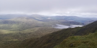
Yay! The cloud has lifted! I can see where I'm going (Kirriereoch Hill is the second lump in this snap)

I pointed out to Mick where I was going after Kirriereoch: skirting this end of the loch and heading up Mullwharchar which is the lump on the left, on the other side of the loch.
Kirriereoch has had a relatively recent promotion to the Marilyn list (it's not in my gpx file of the summits), with a barely-qualifying 150.2m of prominence. They were fairly easily gained metres too, with the going being rough grass rather than tussocks.
After an initial retracing of steps I took a steep descent (where the mapmakers couldn't squeeze more than two intermediate contour lines between each 50m marker) down to Loch Twachtan, which I skirted to reach the ground that looked rough and wet from above. It turned out not to be as bad as expected and I made it round the north end of Loch Enoch without plunging my feet in any bogs (or tripping over any rusty wire, which was just as much of a triumph, given how much of it was lying around adjacent to the fence line).

Approx line of descent from Kirriereoch Hill to Loch Twachtan, skirting the top of the first landslide and crossing the second.
Considering the last two days' efforts, I was surprised at how good my legs felt ascending Mullwharchar, which was supposed to be my last hill of the day. Hiding behind a large boulder on its summit (the wind was getting inconveniently strong by now) I paused for a quick lunch and contemplated the map. Then I wandered over to a vantage point from where I could see Craignaw (there the wind whipped off both my hood, which I'd been using to keep my hat in place, and my hat; I did manage to retrieve it). I then performed three more circuits of the summit, trying to regain the good phone signal that had mysteriously disappeared, to send Mick a message to tell him of a change of plan. I had intended to return over the undulating Rig of Loch Enoch and Buchan Hill, which would have had no benefit from a Marilyning point of view; I'd now decided that it would be little more effort (and only 1.5km further) to go over Craignaw instead.
I was excited to find a trodden line sporting boot, rather than deer hoof, prints on the way. Then I lost the trod, but encountered a group of a dozen or so walkers. They were, of course, on that elusive trod. I took to that line, but with such a landscape of great slabs of rock, I soon lost it again. I'm pretty sure the group I passed hadn't descended my final ascent route to the summit of this hill; it was a touch on the steep side!
Mick called me just before I reached the top, having nipped out to find a phone signal to find out how I was getting on. This was good, as it confirmed that he knew my new plan, and thus I didn't have to rush to get back to Bertie by the original 'expect you back by' time.

My hood was up on every summit-selfie, mainly just to keep my hat in place in the strong wind.
Being long out of water, I needed to have an aquafaff at the burn on the south side of Craignaw, which looks, on the map, like a good reliable water source. I intersected it about half way down its lengh to find it dry, and thus had to divert further down to find water. I wouldn't class it as a quality water source but I was thirsty. Then I found that my filter (a Sawyer Squeeze) is in need of backflushing. Then I found that the filter bag has a hole in it. This was not going well! I managed to suck half a litre through anyway, and took another half litre away with me.

I didn't have to drink that final half litre, as part way down the Gairland Burn path (a real path! Marked on the map and in unmissable existence on the ground!) I saw a chap carrying a bottle of water walking towards me and I snatched it out of his hand and drank it. Then Mick turned and walked the final couple of kilometres back to Bertie with me.
That leaves me with just one nearby hill unbagged (I was tempted to tag it onto the end of today, but resisted). I'm hoping my legs will be amenable to nipping out to it tomorrow.


No comments:
Post a Comment