The Road goes ever on and on; Down from the door where it began;
Now far ahead the Road has gone; And I must follow, if I can;
Pursuing it with eager feet; Until it joins some larger way;
Where many paths and errands met; And whither then? I cannot say.

[JRR Tolkien, Lord of the Rings]

Showing posts with label Wales Coast Path. Show all posts

Thursday, 19 March 2015

WCP: Llanmadoc to Gowerton

Thursday 19 March 2014

Distance: 17.6 miles

Weather: Glorious again, although hazy views

I tend to wake up early when out and about walking on a Colin-based trip, mainly because I tend to fall to sleep too early. I woke up early again this morning, which was a bit annoying as it had been a later night than usual and I hadn’t slept well. As a result I felt like i was going really slowly today (hmmm, just looked at my speed profile for the day and my perception and reality don’t quite align).

Unusually, Mick started out with me today, on the basis that 5 miles after setting off the route would take us back within 500 yards of where Colin was parked, having walked up one side of the narrow spit of Whiteford Burrows and back down the other side.

If I had paid more attention to the path closure notice before we set out along the spit, I might have decided to omit the excursion (even the official Coast Path gives the option to omit it), but I’m glad that I didn’t pay more attention, as this spit is well worth a visit. The west side was a large expanse of beach sided by dunes (after today’s news, I looked out for wet wipes washed up, but all I found was the usual thousands of pieces of plastic of various shapes, sizes and types):

IMG_8505

Then, within yards of rounding to the east side we were in a green land with a large variety of plants.

IMG_8509

It was definitely the highlight of the day, even though we did then find the continuation of the path to be closed (yep, we ignored the closure, hopped over the gate and went to have a look at the ‘washed away section of wall’ which confirmed to us that it’s not passable), causing us to perform a closed loop around the point. With Mick headed back towards Colin, I continued on the 1-mile diversion. I was certainly glad a while later that I had mis-marked the route on my map and didn’t need to walk right the way into Cheriton, as there are now stepping-stones and a permissive path cutting across the marshes.

The following path along the marshes was interesting but not spectacular, then it was onto tarmac for the rest of the day (bar a little section of fields right at the end of the day).

I finished my day at Gowerton Caravan Club Site, even though I knew that it doesn’t open for the season until tomorrow. Instead, we’ve driven a little way to park up for the night, right on the edge of the salt-marsh where we’re watching the tide come in and hoping it’s not a high enough tide to cover the car park (which it clearly does sometimes).

WCP: Port Eynon to Llanmadoc

Wednesday 18 March 2014

Distance: 13.2 miles

Weather: wall-to-wall sunshine

I had an incentive to walk briskly today, as I have a friend who lives on the north side of the Gower and the sooner I reached Llanmadoc, the more afternoon we would have available to us to catch up. Thus, I set off at a clip … and made a complete meal of the first mile of the day due to deciding to shun the official path in order to stay closer to the coast. I eventually got back on route, but not without a bit of scrambling and more ascent than if I’d just followed the WCP to start with. Ah well, you win some…

Ascent was a minor theme of the morning. Underfoot the path was lovely and, once again, the surroundings were spectacular (particularly under the gorgeous blue skies), but it did involve lots of sharp little ups and downs.

IMG_8495

Having rounded Worms Head (which I could have visited as the tide was low, but it would have been an out and back for no great reward, so I didn’t), I met (with 7 miles walked) the first other walkers of the day. I’m not sure where everyone was; there weren’t even dog-walkers to be seen.

Below me now was a massive expanse of beach (about 3.5 miles long and, being low tide, very wide) and, as I suspected from the map, at Rhossili I was able to access it. In so doing not only did I have some delightful sandy walking, but I missed out a few wiggles in the official path as it heads through the dunes.

IMG_8498

There was only the smallest handful of people on that beach (really, where was everyone on this gorgeous sunny day?), and one of them was Mick walking towards me out of the haze.

Being just a few minutes after low tide when we reached Burry Holm, we probably could have continued on the beach to round the headland and the next little bay, but we took the safe option of heading up into the dunes (as it goes, looking from above we reckon we could have made it around at sea level, but it looked like there’s probably only a very small window of opportunity around low tide).

We could have stayed on the beach all around the west side of the isthmus at Whiteford Burrows, but that wasn’t on the agenda for today. Instead, inland we went to find Colin parked just where Mick had left him in Llanmadoc and soon we were sitting drinking tea and putting the world to rights at Rhian & Paul’s house. An excellent afternoon and evening was had, after a fine morning’s walking.

Saturday, 14 March 2015

WCP: West Aberthaw to Ogmore

Saturday 14 March (0730-1410)

Distance: 15.8 miles

Weather: Dry, but overcast

There is much that I could say about today and it’s going to be difficult to choose what detail to include and what to omit. I fear that in making those decisions, I’m going to fail to be concise. The headline is that today’s coastline was lovely, with plenty of interest along the path.

There was one downside of the first 7 miles, and that was mud. I knew, in setting out on Tuesday, that we were still in mud season, but those first 7 miles were the muddiest mudfest, which saw me taking tiny careful (squelching) steps and still slip-sliding all over the place.

IMG_8390 Typical of the first 7 miles of today. I suppose it did rain quite a bit yesterday, though.

That, however, is the only negative thing I can say about the day. Some paths around fields were largely inoffensive (except for their muddy state) but uninteresting, but the majority of the day was along the cliffs. Interesting cliffs they were too, with clear sedimentary layers being evident.

IMG_8391

Mick met me just before a very interesting place called St Donat’s (a very well preserved fortified village, by the looks of it), of which I failed to take a decent photo, and we walked together back past the a lighthouse complex to where Colin was waiting to provide me with a comfy seat for elevenses.

IMG_8402

The one thing that has surprised me over the last 20 miles of coast is how many surfers there are. I’d seen a few yesterday afternoon, then about an hour before dark our car park suddenly filled up with chaps who leapt out of their cars, donned wetsuits as fast as one can don tight neoprene and ran towards the sea with their boards, obviously eager to spend as much time as possible in the water before dark. It’s now become apparent that wherever there is access to a beach, there will be a small handful of surfers. Three provided us (or me) with good entertainment as I took elevenses, as they pulled up right in front of Colin, leapt out of their cars and promptly (without any efforts to conceal themselves on the far side of their vehicles) stood in full view and stripped off *all* of their clothes before struggling into neoprene. I say! I almost blushed.

Leaving Mick to scoot on round to park near the end point of my day, and walk back from there to meet me again, I continued (blissfully on firm grass; I’d been dreading another 8 miles of mud) along more lovely coast, diverting where necessary up and around a gorgeous wooded inlet, then passing the remains of a fort/fortified house and a (closed) visitor centre before bumping into Mick again.

Half the world was out along the next section of coast, and who can blame them? There are definitely many worse places to spend a nice dry Saturday in March.

A couple of miles of out-and-back inland diversion is required at Ogmore, to get to a bridge over the river, and along that section I stopped for a wonky lunch (which is to say, I stopped for lunch in Colin, who was parked on such a slope that it was a two-man effort to retrieve stuff from the fridge without the entire contents sliding out*). It was then just a mile to the point where it made sense for me to finish my day. Mick (who managed to walk a total of 10 miles in walking out to meet me today) was happy enough with my early finish: as I type he is happily shouting at the rugby.

(*It confounds me as to why Colin’s Thetford 3-way fridge, which is clearly designed for moving vehicles, does not have shelves with a lip on their edge.)

Thursday, 12 March 2015

WCP: St Brides Wentlooge to Lavernock

Thursday 12 March (0830-1345)

Distance: 16.7 miles

Weather: Misty, but dry save for about 10 spots of rain

That was a day that did not go as well as I would have liked. A day that caused me to declare that ‘I hate Cardiff’. A day that caused me to spend a good ten minutes whinging as soon as I met up with Mick in Penarth.

The first five miles were all good (even if I did have to negotiate my way around some path-blocking, big-horned, hairy coos), with lovely salt flats and lots of bird life. Then I got to a place where my map told me I needed to turn inland, but the waymarks on the ground were contradictory and I decided to follow a marker.

By the time I concluded that I was most definitely not on the official route anymore, I was loathed to turn back, so praying that I could get out at the other end I ploughed on over less-than-ideal terrain. With three sides of a square walked, I rounded a bend to see very tall, barbed wire topped gates ahead of me. Noooooo! I really didn’t want to backtrack for more than a mile over salt-marsh!

I didn’t backtrack. I didn’t scale the tall gates, or the adjoining fence. Much mud was involved. But, I did get back on track, and I had been far truer to the coast than the official route at this point.

Then I got to this bit of the path:

IMG_8370

I’d already passed one bit which was completely blocked by fly-tipping, before I got to this patch of wasteland, which is adjacent to a permanent gypsy site. The path then took me behind that site (being chased by a goose part of the way), where I could have taken many photos of the mess, but I settled for this one:

IMG_8371

Ploughing on a little further (incredulous when I passed way marks which confirmed that I wasn’t reading my map wrong; why did the planners pick this as a suitable route?), I saw someone and a dog ahead of me and suddenly felt convinced that person was a mad axe murderer and the dog a killer one. So, I back-tracked, made my way across more wasteland, waited for what felt like a week and a half for a gap in traffic to cross a road and took an alternative route. An industrial estate took me to a housing estate, of the sort where many gardens were adorned with various types of household waste. It certainly wasn’t the best introduction to Cardiff.

Back on the proper route things didn’t get better when, at Atlantic Wharf, I had to walk past two drug-smoking hoodies who looked me up and down in such a way as to cause my unease to rush back. Again, I made for the road and followed it to Cardiff Bay.

At the Bay Cardiff started to redeem itself, although either a lack of waymarks or a lack of concentration on my part saw me wander off towards the wrong side of the bay. I wouldn’t have taken this photo from this location if I’d been heading the right way:

IMG_8374

I’m pleased to say that from there nothing more went awry (apart from the discovery, at the end of my day, that my Fitbit battery had expired 5 miles into the day, and that I had forgotten to restart the Garmin Gadget after pausing for elevenses), and just after the Cardiff Bay Barrage I saw a familiar man walking towards me. He duly put up with me venting my whinges about the day, before we proceeded (up, down and along) through Penarth, which gave excellent opportunities to oggle some sizeable, sea-facing houses.

I confess that I was tempted to continue on for a few more miles, as I had finished my day so early, but the legs are reminding me that they’ve become unaccustomed to this level of walking, so I’m being kind to them with an afternoon off.

Wednesday, 11 March 2015

Wales Coast Path: Chepstow to Gwndy

Tuesday 10 March

Distance: 11 miles

Weather: Absolutely glorious!

If I’d put a bit more thought into today’s walk, I probably wouldn’t have chosen to start it in Chepstow itself. The reason I did so was purely because that’s where the Wales Coast Path starts/ends, and I failed to think about the fact that I’d already walked the bit between the M48 and Chepstow.

If those first three miles had any merit, I wouldn’t have minded the repetition, but so unremarkable are the residential streets and back alleys which comprise the WCP at that point, that I had no recollection whatsoever of having walked that exact route just short of 7 years ago. However, I’ve just revisited the map file entitled ‘LEJOG Actual Route’ and it’s undisputable that I have walked those miles before.

Here’s a taster of the first bit of the route:

IMG_8327

Residential roads and alleyways did eventually give way to fields (via a tunnel under the M48 with some excellent street art adorning its walls), but not all of those fields were a joy to walk. This one in particular was horribly churned up by cows. The bits by the gates were particularly ‘interesting’:

IMG_8335

Just beyond that field things picked up remarkably, when I finally hit the coast. Walking along the embankment, with views of both Severn Bridges, and with the sun beating down, I no longer had any complaints to make:

IMG_8340

Even better, Mick was walking towards me from our night-stop and in so doing was able to explore whether it was possible to walk through the firing range today, rather than following the coast path as it goes around the houses behind it. He reached it just as the red flags were being taken down … and half an hour later he walked it again in my company, which saved me a good mile of inland walking.

There was a definite feel of spring in the air again today, and I wouldn’t have felt under-dressed in a pair of shorts. Alas, the forecast tells me it’s going to be a full-waterproofs day tomorrow.


(Aaarrrrggghhhhh! I took the time yesterday afternoon to make another batch of flapjacks to power me through his week’s walking activities. There are now 20 pieces of flapjack sitting in a tub on the kitchen work surface at home, which isn’t an overly handy location for the fuelling of a walk in South Wales.)

Monday, 2 June 2014

WCP: Sychnant Pass to by Penrhyn Castle (Bangor)

Monday 2 June (0605-0955)

Distance: 11.9 miles

Weather: Light rain showers

Anyone with an uncommon level of attention to detail, coupled with a good memory, may remember that four days ago I described this as a three-day trip. It would have been more precise to say that this was a 72-hour trip as, having set out from Chester at 10 on Friday morning, we needed to be on our way home again at 10 this morning so as to be in good time for an appointment this afternoon.

Four days (even where the fourth day has to end by 10am) is a much better timescale than three days to complete a walk of just over 76 miles, and thanks to having walked as far as I did yesterday, it was looking feasible that I could today achieve my objective of reaching the point where I’d ended my Anglesey trip at the beginning of May (the end point of that trip not being on Anglesey, but by Penrhyn Castle, east of Bangor).

An early start was called for to achieve the objective, so out I strode at just gone 6am, past the ponies grazing by the van, and down the road. Then I went back up the road, collected my hat, and started over.

The inland route of the coast path doesn’t go over Foel Lus, but I did. It seemed rude to skirt such a nice looking hill, moreover, when there was a very good path to its summit (why is there such a well-used path? I can’t find this hill on any hill list to suggest that it’s a ‘bagger’s’ target.).

IMG_4086

As well as the good path, there’s a substantial shelter on the summit, again suggesting that this is a popular little hill:

IMG_4090

The views from the top made the effort to get up there worthwhile. Here’s a snap back to Great Orme, with cloud just starting to drift in at low level (good job I was up there early, before the cloud came down):

IMG_4092

On the plus side, by taking a direct line up Foel Lus (whereas the official coast path zig-zags up the steep hillside then skirts the top of the hill), I had knocked a mile of distance of my day, bringing it down to just over 12 miles. On the negative side, by 7.30am I had covered only 3 miles, which was making my 10am deadline look in jeopardy – and I really didn’t want to have to stop short unless I really had to.

As well as picking up the pace, I resolved to minimise faffing (which usually takes up a good chunk of my day) and forego any breaks. That resolution lasted until just after I spotted this:

IMG_4096

A rainbow ahead of me didn’t bode well for a continued dry day, and sure enough, within ten minutes I was having the first of a few waterproof-faffs. In between showers it was far too warm for a jacket, so it was on and off repeatedly.

A combination of jogging down the joggable downhills and cutting another bit of distance by taking an public footpath which represented the short edge of a triangle of paths (whereas the official route, inexplicably, switches back along the two long edges), meant that by the time I strode through Llanfairfechan I was moderately optimistic that I wouldn’t be many minutes late in arriving at my destination.

Forgetting to pick up my poles after stopping for another waterproof-faff, forcing another retracing of steps, and then another backtrack when I thought the path had been re-routed around an area of erosion, caused me to have to march through the last few miles. Fortunately, even my marching pace is still slow enough to take in the surroundings, even if I didn’t pause for many photos. I did quickly grab a snap of this chap (ex-chap) who made me jump when I looked where I was about to put my foot:IMG_4100

I strode across the litter-strewn car park (McDonalds and Costa detritus, mainly) at my finish point at 0953, but Mick wasn’t there. Whereas at the beginning of May the height barrier had been open, today it was closed, barring Colin from entry. Squeezed instead in a farmer’s gateway, he hadn’t been able to desert Colin to walk out to meet me – but he did have a cup of tea waiting for me when I arrived Smile.

Back to the Midland we then came, having had a thoroughly enjoyable 72 hour trip (well, I thoroughly enjoyed the walking, and I believe Mick enjoyed his bit of walking and all of the reading he did). That section of the coast was so much better than I had expected it to be.

Thanks to this morning’s short jaunt, when I return to do the rest of the coast (which may be over two trips, rather than just one), I can finish at Menai Bridge, having now completed all of Anglesey and all of the coast between Chester and the Menai Bridge.

WCP: Rhyl to Sychnant Pass

Sunday 1 June (0630-1645)

Distance: 26.3 miles

Weather: Mainly sunny. Some hazy cloud later on. Warm.

If anyone had just been driving out of the campsite as I was leaving this morning, I would happily have begged a lift to take me back to the coast, but at 6.30 on a Sunday morning I appeared to be the only person up and about, so off I set on foot.

IMG_4032

Lots of beach – and my head and shoulders, just to prove that it was sunny…

Thanks once again to the tides being right, much of the first part of the day was along the beach, saving my feet from the concrete of the promenade. Having learnt from yesterday (which ended with my trousers in such a disgraceful, muddy state that I washed them as soon as we got back to the campsite*) when I found myself straying into the same sort of horrible mud into which I sank yesterday, I stopped, thought and did the sensible thing, backtracking to find another way around. A little sand did, of course, make its way into my shoes, but just a few grains, rather than yesterday’s half-a-beach.

Eventually the sandy beach came to an end so up to the tarmac I scrambled, where I found there to be a huge number of cyclists out enjoying the warm Sunday morning.

IMG_4042

The smallest church in the British Isles (at Rhos on Sea), apparently. It seats 6.

After a bit more beach in Colwyn Bay, it was back to the promenade (where I passed some open public toilets!! Those two exclamation marks are thoroughly warranted; open public toilets have not been a feature of this trip, which can be a bit of an issue for a girl walking along beaches in populated areas), not because the beach became impassable on foot, but because I thought Mick may pass by on that section, and I would have been very glad to pick up my earphones which I’d forgotten. He (sensibly) bypassed the road I was on to go straight to Llandudno to bag a parking space, so my audio book remained at the point I left it yesterday until much later in the day.

The coast path doesn’t go over the top of Little Orme, but I did. It’s such an easy walk from the official route to the top, that it would have been rude to omit it. From the top I could see Mick (or more precisely, Colin) and once I’d phoned him and he’d dug out the binoculars, Mick could see me too.
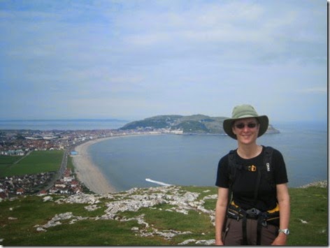
IMG_4051

A self-timed photo taken atop Little Orme, with Great Orme behind me

Not long later, I was inside Colin with a cup of tea and enjoying an early lunch. After a good long break, I didn’t set out alone, as Mick joined me on the next section. I have to confess that I omitted a bit of coast here. The coast path doesn’t go over Great Orme, but I did, and in so doing I omitted the walk along the road which runs around the edge of Great Orme Head. Purists may claim that in making decisions like this, I haven’t walked the coast of Wales, but as I won’t be claiming a badge, certificate or other recognition, I didn’t lose any sleep over my decision to see the views from on high, rather than walking a road.

IMG_4056

A goat on the way up Great Orme. You may note that it has just one very impressive horn. Surely that amount of weight on one side of his head must give him a dreadful crick in his neck?!

With motorised transport options of cable car, tram and car, there were a lot of people on the top. I suspect that I was the only one who had walked there from Rhyl!

IMG_4057

Not the most attractive summit when viewed from the east

IMG_4058

Rather more attractive in the other direction

Mick accompanied me down the other side, before taking a road back to his start point, as onwards I continued, through more throngs of people enjoying the seaside on this fine day.

IMG_4062

Unfortunately, you can’t see that the woman is engrossed in her mobile phone – just like the youth of today!

IMG_4064

Bit of storm damage. Sea wall, roadway and sections of the wall beyond all washed away.

Not being entirely sure how far I was going to want to walk, Mick kindly waited for me again in Conwy, where I likely would have stopped for the day, except that if I want to reach Bangor before we have to head home tomorrow, I needed to get another few miles in today. So, after another good, long break I hauled myself back to my feet and off I set.

There are two route options from Conwy: the coastal route which follows the cycle path which runs adjacent to the A55 dual carriageway; or the inland route which goes via Conwy Mountain. Whilst I didn’t mind the adjacent-to-A-road route the other day, that was only a couple of miles long, whereas this was lots of miles of tarmac, often sandwiched between the dual carriageway and the railway. Thus, I chose the inland route, except I didn’t stay true to it as the inland route doesn’t go over Conwy Mountain and I did. As per Little Orme earlier in the day, it seemed rude to get that close and not go to the top. By this time, the day was very warm, I was very hot and my mind was protesting at me hauling my body up another hill in these conditions. The mental protests were ignored and the effort was thoroughly worth it for the views from the top.

IMG_4079

Looking back to Great Orme. All of my route of the day was visible to me from this vantage point – and it looked a jolly long way!

Down was then the direction of travel, all the way to Sychnant, where Mick was duly found, patiently waiting for me.

IMG_4082

Colin’s pitch for the night

Another excellent day.

(*Given that this wasn’t a backpacking trip, I really ought to have packed more than one pair of trousers in case of obscene-amounts-of-mud incidents. In fact, a pair of shorts would have been a good idea considering the weather.)

Saturday, 31 May 2014

WCP: Rhyl to Greenfields (Holywell)

Saturday 31 May (0700-1440)

Distance: 20.5 miles

Weather: Overcast start clearing to wall-to-wall sunshine

Setting out for a walk with low expectations often leads to a pleasant surprise, and so it was today. From the map, the Wales Coast Path along this north coast looks to me like it features far too many hard surfaces and, today in particular, more than its fair share of tacky seaside resorts.

My perception of Rhyl was based upon its 1980’s reputation, rather than first-hand knowledge and thus, when I found a resort which is obviously investing substantial money into modernisation, I was pleasantly surprised. Admittedly, I didn’t investigate the town at any length. Having walked the mile and a half from the campsite back down to the coast (lovely campsite; pity it’s not nearer to the coast!), I only walked about a mile along the promenade before taking to the huge beach.

IMG_4004

Beaches then featured highly in the day, as I’d caught the tides right, and thus I almost bypassed Prestatyn too, only deviating to the prom for a while when I got fed up of sinking to my ankles (and beyond) in mud when crossing the many streams which run down the beach.

The spot I chose for second breakfast turned out to be the very end (or very start, if you’re southbound) of Offa’s Dyke Path, then back down to the beach I went, skipping back and forth between beach and concrete depending on the firmness (or lack thereof) of the sand.

My efforts at removing sand and mud from inside my shoes and socks at second breakfast time had been nugatory, as more beach wanderings saw more streams and more sinking into mud. Just as I was getting fed up of having half the beach inside of my shoes, and mud up to my knees, I looked at the map and realised that I had a river crossing coming up and if I wanted to cross via a bridge then I needed to be heading 90 degrees to my right.

Such was the level of gloopy mud on my shoes and sand/silt inside of them, that upon finding a pond on my route to the bridge…

IMG_4006…I took a break to give my shoes and socks a good wash. My feet felt much more comfortable when I continued and, more importantly, I managed to avoid deep sandy mud for the rest of the day.

People were out in droves on the beach at Talacre, where the old lighthouse makes for an interesting landmark, but once I turned the corner at that lighthouse, I was on my own again.

IMG_4010

Having passed the unattractive industrial site (chemical factory of some sort??), at 11.30, hunger was getting the better of me, so I plonked myself down for an early lunch in lieu of elevenses, but before I got started, I just thought I’d give Mick a call to see where he was. It turned out that he had just left the campsite, heading in my direction, and as I was about to walk the road for a while, it seemed sensible for him to meet me and for me to enjoy a cup of tea with my lunch, whilst sitting on a comfy sofa (not to mention changing into dry socks and shoes Smile)

After lunch, I had intended to head inland a little way, where an official alternative route avoids walking along the A-road for a while, but suddenly an attack of laziness came over me causing me to plump for the road. I’d had a pleasant morning of soft surfaces, so I decided I didn’t mind a bit of tarmac, further justifying the shorter route on the basis that it does run nearer to the coast and this is supposed to be a coastal walk. Whilst some of that chunk of the road was along a pavement, a significant chunk was far enough away from the road such that it wasn’t visible or intrusive.

IMG_4014

Part of the ‘along the A-road’ route – the road’s out of sight to the right

Back on the edge of the sea, it looked to me like there was a ship in front of me, but initially I thought it must just be some industrial building. Getting closer, I remembered Conrad’s blog post from when he circumperambulated Wales, and realised that this was the Duke of Lancaster – a decaying ‘funship’ which has now been decorated with some impressive street-art. You can read more about it (on Wikipedia) by clicking on this very sentence.

IMG_4021

After battling through a herd of cows, and with views of the Wirral often obscured by the sea defence formed by tall piles of huge rocks, suddenly Mick was before me, reporting that I didn’t have much further to go. Sure enough, after making our way through another herd of cows, which seemed intent on standing exactly in our path, we were back on the mud flats and, a hop, skip and a jump later, we were back at Colin, parked exactly where Mick had picked me up yesterday.

IMG_4028

A view-blocking sea defence (and proof that I was there!)

It had been a fine day of walking, in unexpectedly fine weather.

WCP: Chester to Greenfield (Holywell)

Friday 30 May (1015-1640)

Distance: 17.5 miles

Weather: Overcast, but dry and warm

It occurred to me yesterday afternoon that, as all of the things which were meant to be occupying me at the moment have either been postponed or cancelled, there was no excuse to continue in the laziness that has come over me since the end of the TGO Challenge. Our daysacks and Colin were swiftly packed, and this morning we wended our way to Chester for three days along the Wales Coast Path.

Our packing had, perhaps, been a little slapdash in its hastiness. On arrival at our destination (which happened to be Aldi’s car park) we found that our flasks of tea, Mick’s wind-shirt and our sunglasses were still at home. Aldi was able to resolve Mick’s lack of a light jacket, but not the other two omissions.

The feeling of ‘this isn’t a very good start to the trip’ didn’t abate as I started walking. A lack of footpath maintenance meant that to reach the point where the border intersects the River Dee, I had to climb a gate, wade through thigh-deep grass, then don my over-trousers for nettle protection (whilst fighting my way through hawthorn at head level) in negotiating the stile on the other side of the field .

IMG_3983

Once onto the bank of the Dee, the going was perfectly straight-forward: a tarmac (oooh, my favourite!) cycle path. I said a few dozen greetings to passing cyclists and sped along until, about five miles later I crossed a bridge, per the Coast Path Signs.

IMG_3988

A few minutes later, I crossed back, upon finding the coast path to be closed. It would have been nice if a warning of the closure had been given on the east side of the bridge, where a perfectly viable alternative route existed by continuing along the cycle path..

By the time I got to Connah’s Quay, Mick had parked Colin at Flint Castle and had made his way back to meet me, our path intersecting outside of the church. In other circumstances, we would undoubtedly have stopped on the bench in the (very well kept) churchyard for lunch, but as a wedding party had just come out of the church for photos, we didn’t think they would appreciate our presence. It turned out to be a Very Long Time later when we got to a suitable lunch spot, and I was mightily hungry!

By good fortune, on his outward leg to meet me, Mick had missed a turn and had ended up trespassing his way for a while. I say that was good fortune as he was able to take me back the same way, which put us nicely through some woodland and then on springy salt marshes, rather than following the official route further inland, along an A-road. I’d recommend the trespass, even if it does involve ignoring quite a few ‘No Public Access’ signs at the power station.

IMG_3993

IMG_3994

Past Flint Castle (where I paused for a cup of tea in Colin before continuing), I became even more glad of Mick having found such a viable off-road trespass, as I unexpectedly found myself treading tarmac again, on one of the few bits of the day which should have been on a soft surface. I had come upon some substantial barriers with a notice simply saying ‘No Access to Flint Cob’, but without any accompanying official path closure notice nor any information as to the extent of the closure, nor any hint of a diversion route. So, I resigned myself to a couple of miles of diversion along the cycle route which runs adjacent to the A-road.

By chance, I rejoined the coast path exactly where the closure ended. The barrier at that end did have an official closure notice, but no useful information and no map because (according to the notice): “There is no alternative route available to pedestrians.” What absolute tosh! I’d just walked the perfectly obvious alternative.

IMG_3996

Having skipped ahead of me and walked back, I bumped into Mick again just before Greenfields, and although I had intended to walk another mile or so, I was so thoroughly tired by the time I reached Colin that I swiftly decided to add the remaining distance onto tomorrow’s walk.

The ‘not quite to plan’ aspects of our day weren’t quite over. Having arrived at our intended Certificated Site campsite for the night (we stay on a lot of CS’s; they’re generally very good), we found that we were expected to pay £15 for a skanky bit of an untidy car park, without any facilities and (most crucially to us) without access to a tap from which we could fill up Colin’s tanks. Ignoring the fact that the site’s location was reasonably handy for tomorrow’s continuation, we made a swift exit and I now type this from a campsite (immaculately trimmed grass, toilets, showers, dish-wash, hook-up, water: £16.15) at the end of tomorrow’s route. That means I’ll walk tomorrow’s walk backwards (not literally…).


(You’ll notice that I’ve just chucked in a selection of photos taken today; they are in approximately the right places chronologically, but don’t necessarily relate to anything said in the text. If I wasn’t so tired as I type this, I would try harder!

This post isn’t going to get posted tonight either – I’m too tired to think about getting the dongle out now to sort myself out with some internet access.)
