The Road goes ever on and on; Down from the door where it began;
Now far ahead the Road has gone; And I must follow, if I can;
Pursuing it with eager feet; Until it joins some larger way;
Where many paths and errands met; And whither then? I cannot say.

[JRR Tolkien, Lord of the Rings]

Wednesday, 23 February 2011

East to West Route: Part 4

The last section of the route, and you may notice that it involves the most indecision too. Whereas on other parts of the route the current plan has completely superseded the original plan, here I have left our options open. It was the approach to Edinburgh that seemed to present the greatest number of options and as it stands we intend to take the longest route – via North Berwick and the coastal route to the Forth Bridge.

image

North of Crieff the spur is a red-herring. I obviously started to plot something and then realised that it wasn’t sensible, but for some reason I’ve not deleted the route.

Rannoch Moor is the next place where I’ve plotted two alternatives. One goes via Kingshouse, along the West Highland Way, to Kinlochleven, the other takes a longer route, but one we’ve not taken before. Barring atrocious weather or ill-health, we’ll be avoiding the WHW as far as possible.

The final indecision is the final push to Ardnamurchan. I originally plotted a longer route to keep off the road as much as possible, but on further consideration conceded that it’s quite probable that by that point we’ll be so focussed on reaching our destination that we won’t mind a day on tarmac, so I plotted the road route too.

We’ll certainly walk some of that road in any case, as once we reach Ardnamurchan we’ll have to walk back east a little way to catch a bus to Fort William so that a train can be caught to Strathcarron.

Tuesday, 22 February 2011

East to West Route: Part 3

On the original plan we would have joined the Pennine Way at Middleton in Teesdale and followed it to Cauldron Snout. It’s a lovely walk, but we’ve done it before. Moreover, on looking at the bigger picture I realised that I’d plotted three sides of a square, so on one of my route-tweaking evenings I re-plotted. Once again, by taking to ground that we’ve not before trodden the route also becomes more direct.

image

On this section we hit and cross out LEJOG route. For about a mile just before the Scottish border we follow the Pennine Way, before we head off along Dere Street towards Jedburgh. A little more repetition occurs after Jedburgh until Melrose before we head off to the north.

More of ‘heading off to the north’ in the next (and final) route post…

Monday, 21 February 2011

East to West Route: Part 2

By the way, my splitting up of this route into parts is completely arbitrary. It’s simply as much as I can fit onto my screen without faffing around too much with overlaps.

image

Originally I had planned to head further up the Cleveland Way, to pick up the Coast to Coast route, but finally settled on taking the (approximate) route of the Lyke Wake Walk from Ravenscar. It has the advantage of being a route that we’ve not taken before, and also cuts 10 miles off the original plan. Otherwise, I don’t think that I changed too much on this chunk.

Sunday, 20 February 2011

East to West Route: Part 1

With precisely one month to go until we start walking from Lowestoft (deep, calming breaths), I thought it was about time that I announced our chosen route.

As planned our East to West route totals 798 miles. In reality (on paper, at least) it will be less than that, as experience suggests that in some places I will have inadvertently plotted an unnecessarily circuitous route and in other places we’ll opt for a slightly less attractive direct route for some reason. I expect that it will come out at around 775 miles.

Here’s the first chunk of our intended route:

image

You’ll spot that in some places there are two alternative routes plotted. This is the refined version – originally I plotted a ridiculous number of options. For example, one possibility was to head up to the north coast of Norfolk and follow the coast for a few days before dropping down to King’s Lynn, but after much pondering and for various reasons we’ve opted for the inland route, and hence the coastal alternative is no longer shown.

In case you’re wonder, all the yellow labels show the location of campsites (the red labels showing the location of campsites which, for one reason or another are unlikely to let us stay).

Part 2 to follow…

Saturday, 19 February 2011

Catch-up (2)

Thursday 17 February

Thursday wasn’t one of my allocated working days, and I usually try to get in a decent walk on non-working days. This week, however, I needed to pop into work on Thursday afternoon, but didn’t want that to scupper my need for a walk, so I hatched a plan to combine the two by walking into work.

A bit more consideration told me that walking 19 miles, in my current state of fitness, in order to arrive in time for a 2pm meeting, was unlikely to see me arrive in a fit state to do much, but after a bit of thought the answer was found.

By catching a bus to Burton the walk was reduced to just 13 or so miles. As it went I walked a bit further, because at the point where I was supposed to leave the Trent & Mersey canal and take to the roads I decided that I couldn’t face 4 miles on roads (I drove those roads each day and they’re not dreadfully inspiring), so I opted to walk a little further, be traffic free and not have to walk through any dodgy estates. The re-routing saw me joint National Cycle Route No. 6 – the same cycle route as we’d been on a week earlier in the Sherwood Pines Forest Park area. That set me to wonder where the route starts and ends, and a bit of Googling has told me that the route will eventually link London with Keswick.

I was pretty impressed that of the 14.25 miles that I covered, only the first quarter of a mile and the last quarter of a mile was on road. The rest of the route was entirely traffic free; I didn’t even have to cross a road.

IMG_2086 Floodedness just before the Trent & Mersey crosses the River Dove

IMG_2088Funnily enough, warnings of quicksand are not something that I associate with the Midlands. Happily I managed to clear the area without getting sucked in… 

Friday 18 February

Thursday had seen me walking under grey skies and Friday was no better in terms of weather. What was better was that I had company as Mick joined me to walk to the library to return the maps of Scotland that I’d borrowed to plan the TGOC route.

The high route was shunned due to the certainty that it would be muddier than a muddy place, and so it was to the canal tow-path that we took (which was surprisingly low on mud levels, given the mud-fests that I’d encountered the previous day).

By cheating and driving to the other end of the village first, 11 miles were covered, with a mind-boggling 200 feet of ascent!

IMG_0563

Be thankful we don’t have smellivision; it was a smelly brewery day yesterday.

Saturday 19 February

Today was supposed to be a long walk, but awaking to the sound of rain I wasn’t moved to jump up and get out of the house. Instead I procrastinated by cooking six more meals and putting them in the dehydrator, which delayed us long enough to give the rain time to stop. Per the forecast, so it did, and off we went to the Chase to enjoy a mainly-mud-free route (or so we thought).

Well, it must have rained some last night! Never have I seen so much standing water on those paths and tracks. On some of the tracks it wasn’t even standing water; rather, we were walking up- or down-some significant streams. It had been a poor decision on my part to take a change from the perfectly water-tight boots that I’ve worn so far this year and use an old pair of Salomon’s which I know to leak!

It was dreadfully grey too, with cloud covering the highest points, but on the plus side it was dry, save for a bit of mizzle, and extraordinarily quiet (when we arrived at Stepping Stones, where we stopped for a cup of tea and a hot cross bun, there was not a single other person within sight; that has never happened before).

With 8.25 miles covered we arrived back at the car to be pounced on by two people wearing fluorescent yellow jackets and wielding clip-boards. Their mission was to conduct a simple survey, and we were more than happy to take part, but they couldn’t have chosen a worse day for it in terms of numbers of people passing by. The forecast is better for tomorrow, so hopefully we’ll get our long walk in.

IMG_0068a

Shhh! If you don’t tell anyone that I forgot the camera today then they’ll not know that this photo was taken 11.5 months ago. Today I was wearing the same hat, jacket, trousers and boots, but was rather more muddy, and didn’t have that backpack or pair of gloves with me.

Friday, 18 February 2011

Catch-up

A couple of weeks have passed in silence, but that’s not indicative of my mileage having slipped. Here’s a bit of a catch-up:

Tuesday 8 February

With a mid-week trip to CenterParcs at Sherwood, Mick & I shunned our usual CenterParcs activities in favour of exploring the local area (with one eye on our rapidly approaching Big Walk Departure Date and continued lack of fitness). So, on the Tuesday I announced our intention to take a 5-mile stroll in Sherwood Pines Forest Park, and Vic, Juan, Tilly and Tony opted to come with us (well, technically, Tilly (being 11 months old) didn’t express a preference on her day’s activities).

The day was glorious (if a touch frosty), which may be the reason why each time I said ‘we can take this path to loop back’ the opinion that came back was that we should take the longer route.

It seems that I completely failed to take any meaningful photos of the day, but this snapshot (which fails to capture effectively the interesting mine workings which were the objective of the shot) does evidence the lovely blue sky:

IMG_2073a The end result was that we overshot the intended 5 miles, eventually covering 8.25 miles. Vic gets a special mention for having carried Tilly the whole way – which was the equivalent of her having a full backpack on whilst the rest of us strolled along unladen.

Wednesday 9 February

On Tuesday’s walk we had passed pretty close to a couple of geocaches, so on Wednesday we decided to venture back through Sherwood Pines Forest Park to see if we could find them.

Leaving the Forest Park on the opposite side to the CenterParcs complex, we took to National Cycle Route No. 6, which follows a disused railway line. Urgh!  Whilst the Forest Park is perfectly nice, the cycle route wasn’t. There’s obviously been a problem in the past with vehicles getting access to that tarmacked route, with the attendant fly-tipping and burning out of (presumably stolen) vehicles. It seems that the vehicular access problem has now been solved, but that the path wasn’t cleared up first. So, the conditions on the route were either extraordinarily slippery (due to leaf cover combined with lack of use) or extraordinarily unattractive with piles of rubbish and strewn broken glass to negotiate.

We were only on the cycle route for a relatively short while, and having found the two caches (one of which was particularly tricky, making us rather pleased to have found it) we were soon back in the Forest Park and enjoying a pleasing walk through native trees as well as the pines.

The outing had seen us covering 9 miles, mainly under grey skies, but at least the rain held off.

Thursday 10 February

“I’m hoping that we’ll be able to trespass along this bit of track” I said, pointing at the map (a bit pointlessly as Mick didn’t have his specs on) “and get into the Country Park that way”. The plan was a very short (2.5-mile) circular walk, including a bit of Rufford Country Park.

My short trespass didn’t quite work out though, causing us to find ourselves furtively skirting the edges of fairways and greens, trying to work out how we could get off the golf course, across a water course and to where we needed to be. The answer turned out to be by walking an extra couple of miles.

It was a worthwhile extra couple of miles though, as we saw bits of the country park that we wouldn’t otherwise have seen, and a very pleasant place it seemed to be. When we find ourselves back at that CenterParcs again, we’ll give the place a better exploration – but on this occasion we had a lunch date to keep, so we were happy with the 4.5 miles we had covered and the two geocaches found.

IMG_2077

Obviously my week for taking pretty crap photos! This is one of the mill buildings in the Country Park

IMG_2080And the view of the house taken from the ‘Broad Walk’ 

Friday 11 February

Shortly after arriving home from CenterParcs our next door neighbour popped around to say that his hedge-cutting man was coming around within the half hour to cut the hedgerows in the field at the end of the garden (we’re talking a tractor-hedge-cutter here, not a man with pair of hedge-trimmers). That meant it was advisable for me to move my car until he was done, and so it seemed sensible to park it just up the road, at the entrance to the estate, and take a stroll whilst the hedge-cutting was on-going.

Darkness was already falling as I set out, so it was just the shortest of my circuits, but better to stretch the legs than not, I thought.

Saturday 12 February

The downward trend in the length of our walks continued, but this time for a good reason as we introduced our 6-year old grand-daughter to the fun of geocaching in some local woods. Only a mile was covered on foot (five geocaches found), but grand-daughter loved it.

Sunday 13 February

An absolute mud-fest in a light drizzle ended the downward trend of walk length, as I took the ‘haute route’ to the supermarket. Not much else to say about it, really.

And so that wraps up last week…

Saturday, 5 February 2011

Did It Wear Off That Quickly?

Last week I observed that there was an unusually high number of people out on Cannock Chase and that many were clutching maps or guide books.

Today couldn’t have been more of a contrast. Remarkably few people were seen during our five hours of leg-stretching and of those we did see most were in the three sizeable groups we passed (one of those groups being 26 people on horseback – an unusual sight).

Was it that Cannock Chase hasn’t received so much publicity this week?

Or was it that few people felt inclined to go out on such a wet and windy day?

TGOC Route

The route has been vetted. Very helpful pointers have been received. I had caused some confusion, but clarification has been provided and it didn’t involve any changes to the route. So, the route is now set.

We’ll be setting out from Strathcarron on the Friday afternoon (working on the basis that we reach Ardnamurchan on the 11th May, wend our way to Fort William on the 12th to spend the night, then head up to Strathcarron on the 13th).

It’d be nice if Loch Carron is looking like this:

Day 49 12

We’re not going far on the first day (given that we’re not planning to set out until after lunch), but Day 2 will see us cover the length of Loch Monar and beyond, positioning ourselves to pop over some lumps above Glen Strathfarrar on Day 3.

Day 4 sees us (perhaps inadvisably) cross Eskdale Moor to end the day in Drumnadrochit, where I’ll spend a night fretting about the impending ferry ride and wondering why I ever thought that a route involving a ferry was a good idea.

The Monadhliath will be the subject of our explorations the for Days 5 and 6. I have no clear picture in my mind as to what this area’s like, but am very much looking forward to finding out, before we land in Aviemore (well, Coylumbridge really).

Fingers crossed for reasonable weather on the seventh day, as the Lairig Ghru has been on my ‘want to do’ list for years so there will be disappointment indeed if I don’t get to see it.

Day 8 is ‘the middle Saturday’ and Mick made a special request to be sociable on this year’s crossing, so on Middle Saturday we’ll arrive in Braemar. We may even stay there for a second night.

Fingers crossed for good weather again on Day 10, as Lochnagar looks absolutely spectacular from the map and I’d like to see how the reality compares.

P5180187

Hopefully there won’t be so much standing water at Tarfside!

Even though Tarfside lies at the end of our eleventh day, our route in differs from the one we took previously, as does our route out the following day, for on Days 12 and 13 we’re going to head over to investigate a bit of the Fettoresso Forest.

A final hop, skip and a jump, before heading down to the bash in Montrose, will see us hit the east coast at Stonehaven.

So, that’s the plan. Given some bad weather it could look quite different – and potentially a couple of days shorter. Did I mention that my fingers are crossed for good weather?


Tuesday, 1 February 2011

January (with a gratuitous graph alert!)

At the turn of the year, when I was announcing last year’s walking statistics, Mick asked me how many miles per day I had averaged over the year. The answer was 4.97. It wasn’t something that I’d considered before, but upon doing that sum, and realising that I’d fallen just 12 miles short of averaging 5 miles per day I decided that 5 miles per day seemed like a good average to aim for this year – or 1825 miles for the whole year.

With the first month of the year been and gone I’m pleased to see that I’m pretty well on target so far.

Here’s this January compared with the same month for the previous five years:

image

“Start as you mean to go on” I always say. It’d be nice if one year I managed to go on as I’d started!

Sunday, 30 January 2011

Just Like the Bradbury Effect?

When Julia Bradbury started skipping up the Wainwrights in Wainwrights Walks, suddenly the number of people visiting the featured fells increased quite notably.

When Julia Bradbury covered Wainwright’s Coast to Coast walk (a week before Mick & I walked it in September 2008; she should have set out a week later as it rained the whole time for Julia and was perfectly dry for us) the number of people tackling the already-popular walk was forecast to soar.

Such is the power of television for putting ideas in peoples heads (and I’m in no way saying that’s a bad thing).

Yesterday morning Cannock Chase was busy. Probably not greatly busier than we’ve seen it before, but unusually so for a cold*, grey January day. Moreover, a significant number of the people we passed were clutching either maps or guidebooks, and that is even more unusual. Most people we encounter over there are striding around like they know where they’re going.

Is it the ‘must get out walking more’ New Year’s resolutions, we pondered.

Is it just a continuation of the rising popularity of Cannock Chase, we pondered further.

My favourite theory though is that the ‘Save Cannock Chase’ campaign (the need for saving stemming from the government’s proposed sell-off of our forests) has been receiving a lot of local radio and television coverage (and even a bit of national coverage) over the last couple of weeks. The Chase is already a popular place (and deservedly so), but it looks like the recent media publicity has encouraged even more to get out there and enjoy what it has to offer.

(*When I say cold, I mean COLD. That was some windchill yesterday! On the plus side, we were able to walk straight across some deep muddy wallows that have always previously required a diversion.)


Friday, 28 January 2011

Should Have Said…

A week and a bit ago we got an email from Roger Smith saying that we had made our way up to places 5 & 6 on the TGO Challenge stand-by list.

Later the same day we were up to 2 & 3.

On Tuesday this week the email arrived to confirm our places.

As I said when we found ourselves on the stand-by list to start with, it’s a strange thing to be willing a place to come up yet feeling sorry for those finding themselves in unfortunate circumstances causing them to have to withdraw. We are, however, undeniably pleased to have it confirmed that having walked our East to West, we will also be having a sociable time walking across Scotland.

As optimistic as I was that our places would come, the route sheet was already filled out. All I’d omitted to do was to run it past Mick, so today I walked into town (via the high-level* route) to the main library to borrow maps so that I can show Mick the big picture of what I’m proposing (I’d already been and sat in the library myself to pore over the big maps – an excellent way to lose a chunk of the day). Next week we will submit our route.

(*the high-level route accumulates a whole 450 feet of ascent, over 7.5 miles, you know! Positively dizzying…)


Friday, 21 January 2011

Gait Barrows Geocaches

After a night in Kendal following Sunday’s walk, Monday morning first saw us revisiting various specific parts of Sunday’s routes, in search of Martin’s missing bunch of keys, including a quick jaunt back up Arnside Knott for me. It was no hardship to pop up there again. It’s a lovely little hill and if I lived nearby I’m sure I would be atop it often.

Just down the road from Arnside Knott lives Conrad, and I was keen to learn more of his plans for this year (featuring a 1000-miles walk around the border of Wales). After much chatting about gear and routes over tea and croissants off we all set to take advantage of the improved weather with a bit of a leg-stretch.

I had noted a number of local geocaches on my map, and even though Conrad had visited most of them before, he was happy to come along on our 5-miles Tupperware-finding mission.

Some of our route followed (in the opposite direction) Sunday’s route, and all of it was quite lovely. Moreover as the weather had perked up decidedly from Sunday’s dampness.

I think this photo was supposed to capture the improved conditions (I’d forgotten the camera, so there were just a few snaps taken on Mick’s phone):

photo

Dampness still prevailed underfoot, mind. At one point the same temporary lake which had caused us a diversion the previous day defeated us again, but we didn’t have to wander far from the path to find a suitable place for a small amount of clambering to get us back on track the other side of the water obstacle. Soon after we were emptying a tub-full of water out of the third geocache of the day.

The final cache of the day required a bit of a round about route, as between it and the previous one lay Hawes Water, and given that none of us can walk on water, three sides of a square were taken. Once we got there I was glad to find that the killer ponies, which had plagued Conrad on his visit to this cache, ignored our visit:

photo1 I’m not sure about that blue jacket. I’ve never had a jacket of that colour before and I just don’t look like me!

It was then but a short walk in the woods to get back to our starting point, but first Mick decided to have a quick play with the 360 degree photo app on his phone:

photo3 The stats for the rather-pleasing outing were 5 miles walked with a whopping 500 feet of ascent and six geocaches successfully found.

Tuesday, 18 January 2011

Leighton Moss, Gait Barrows, Arnside, Silverdale and Leighton Moss

Thirty legs and three tails set out just after 10am on Sunday morning from Leighton Moss RSPB Reserve (Mick & I amongst them) to walk a circular route that Martin had devised.

It was under grey skies that we strode away (although not before pre-hydrating with cups of tea in the Visitor Centre cafe) but at least it wasn’t raining. Those local to the area described the vast quantities of rain that had fallen on Saturday, which explained all the flooded bits we had seen on our drive in, so we counted ourselves lucky that all we had to contend with was mud and puddles.

I’m not sure whether it was the greyness of the day or the chatting that meant that the camera came out neither as we walked through the RSPB reserve, nor as we walked through the lovely (if more than a tad muddy) Cringlebarrow Woods. And then it started to rain. The non-Paramo contingent tried to ignore it for a while until defeat had to be conceded and a waterproofs-faff was had.

Notwithstanding the dampness, I had to dig for the camera when we came to the big limestone pavement at Gait Barrows:
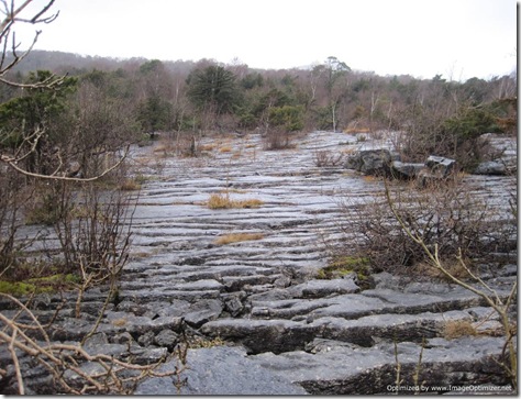
IMG_2041 It’s a pretty impressive feature even on a grey day, but I bet it looks even better when not viewed from under a hood (and maybe with a blue sky).

IMG_2042 A cheery bunch, in spite of the weather

Leaving Gait Barrows our intended path across fields was barred by some lake-sized puddles, but a route around was found, which deposited us in a lane. ‘Much better underfoot’ we thought, until we rounded a corner and came upon another water-obstacle. Single file was the way to attack it:

IMG_2044

Minutes later Hazelslack Tower caused a little discussion as we wondered about its history (built late 14th century apparently, and thought to have been in ruin since the 17th century – information gained from a bit of Googling in the absence of an information board at the scene):

IMG_2045 Thence over to Arnside we headed, where a tiny bit of sploshing through floodedness was unavoidable as we crossed the fields, and a more considerable amount of sploshing was unavoidable when we got herded between two barbed-wire fences. I was verily impressed at this point that my boots were still keeping my feet dry; being five or six years old, I hadn’t had such high expectations for them after a couple of hours of regular dunkings.

The morning tea break had been omitted in the poor weather and there were hints that hunger was setting in for more than a couple of people as we headed up Arnside Knott at approaching 1.30. Happily, the rain had stopped, so at the top a reasonably sheltered spot was found for lunch:

IMG_2047Having been one of the first people offered some of Martin’s excellent brownies, I nearly cheekily scored a second piece when I quickly moved to re-position myself at the end of Martin’s brownie-offering route. He spotted the deception, although maybe it was the fact that I had a mouthful of brownie that gave me away!

It would have been a lunch-spot with a view (see the last posting) on a different day, but on Sunday the view was largely absent:

IMG_2046Back on our way once various flavours of sandwiches had been despatched and flasks emptied, a group photo call was had at the top of the Knott:

IMG_2050 L to R: Rick, Stu, Sue, Sue, Mick, Me, John and Heather

(Martin’s missing because he was taking the photos)

With Arnside Knott being the highpoint of the walk, ‘down’ was the theme for a while, as we made our way into completely different surroundings as we reached the beach at Silverdale.

IMG_2054 IMG_2053 The features were coming thick and fast as we passed by Woodwell:

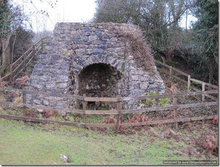
IMG_2058 and Jack Scout lime kiln:

IMG_2060 before taking to the coast once again, where the sun very nearly made a proper appearance:

IMG_2062 Of course, being so close to the coast does lead to some dangers, but I think I would have struggled to come up with quite so many as this warning sign:

IMG_2063

It’s a wonder we all made it back in one piece!

For some reason I failed to take a snap of the beach-dwelling chimney we passed, so I’ve nicked Martin’s:

image

Then it was just the short stroll back to Leighton Moss, except that I didn’t get to stroll all of it. I was bringing up the rear (being some distance to the rear) when I realised that my map was missing. The map wasn’t of particular concern, being just an A4 print out, but those Ortlieb map cases don’t come cheap, so back down the hill I trotted to find it, then back up I trotted trying to catch a glimpse of the rest of the group. The pace wasn’t slow at this point, so it was quite a while before I caught up (and then probably only because some had stopped to wait for me).

Just a hop, a skip and a jump it was from there back to the Visitor Centre and with it being still open another pot of tea was deemed in order to round off what had been an excellent day, before Mick and I headed up to Kendal to overnight and the others headed off home.

Here’s the route we took (also nicked from Martin, but I’m sure he won’t mind!):

image Followed without diversion it’s around 12.5 miles long and it’s well worth doing if you find yourself in that neck of the woods. It’s packed with features, and I imagine that it’s even better still if you do it on a slightly more clement day.

Another take on the day can be found here, together with some much better photos than the ones I snapped.

Monday, 17 January 2011

From Arnside Knott

Visibility is a bit better than yesterday!
Sent using BlackBerry® from Orange

Thursday, 13 January 2011

Yikes! Gulp!

I’ve just booked our train tickets to get us down to Lowestoft in March for the start of our Big Walk. Booked a bargain Travelodge room for the first two nights too.

A rail replacement bus service (or ‘bustitution’) on the day we wanted to travel has caused us to bring our start date forward by a day. We’ll now be leaving Lowestoft on Sunday 20 March.

That doesn’t seem a very long way away.

Tuesday, 4 January 2011

From Bleaklow

A fantastically comfortable night’s sleep was had. In fact, the most comfortable night’s winter camping ever. The Exped Synmat got full marks from me for both comfort and warmth, even if I’m struggling to get to grips with the built-in pump. It’s a pity that it’s so bulky, because otherwise I’d happily take the weight penalty to take it on the next Big Walk, but as it is there’s no way that it’ll fit in my long-distance pack (the OMM Villain) if I also want to fit in a few days worth of food.

Having managed to extract half of myself from the snugness of my sleeping bag, a cup of tea was in order, and minus 6 degrees said the thermometer when I started groping around in the porch. If that was right then it made it surprising that the water hadn’t frozen in the water bottle, although it did immediately turn to thick slush upon pouring some into the pot.

Only needing to switch gas canisters once (we had two almost empty canisters with us), from the one that had become too cold to use, to the one that Mick was hugging in his sleeping bag, cups of tea were made and breakfast eaten. By just after 8am we were packing away, noting the occasional stray snowflake as we did so. Still, at least it wasn’t the latterly forecast fog, even if we didn’t get the previously-forecast wall-to-wall sunshine.

Our walk out was a short one. Down the Pennine Way we went, finding conditions a touch slippery in places as we variously encountered snow, sheet ice, bare flags and just plain frozen ground.

IMG_2031Then, just over a mile later, on reaching Old Woman, off we turned down Doctor’s Gate. It’s one of those paths that inexplicably I’ve long wanted to walk (and very nearly did last June), but yet have managed to avoid thus far.

It was snowy and slip-slidey down the first bit of the path, but soon we were below the snow line, and heading down the rather pleasing valley.

IMG_2033You can just about make out the route of the path half way up the left side of the valley in this (washed-out) photo:

IMG_2035A few people were met on the way down, including more fell runners. Added to those we’d seen on Sunday we briefly pondered whether people from Glossop have a propensity to take up fell-running, or whether fell-runners tend to gravitate towards living in Glossop. Either way, they’ve not got a bad location to stretch their legs and lungs.

Just over four and a half miles after leaving our pitch, we were back on the edge of Glossop and a few minutes later were heading towards the cooked breakfasts that had been calling our names.

The stats for the outing were 12 miles with just over 2000 feet of ascent on Sunday and just 4.75 miles with almost no ascent on Monday.


Monday, 3 January 2011

On Bleaklow

“Where are we going to camp tomorrow night?” I asked Mick on Saturday evening.

“Are we going away somewhere?” he asked?

I replied in the affirmative as if it had been a long-held plan, rather than a notion that had just entered my head, and quickly set about gathering gear together and poring over maps.

Sunday

Glossop was the chosen starting point, and Bleaklow as to be the focal point of the walk. By just gone 10.30 we were walking, heading in the slightly counter-intuitive direction (given that Bleaklow Head was our aim) of Padfield, beyond which we picked up the Trans Pennine Trail.

As converted disused railway lines go it’s quite a pleasant one, with a nice soft surface and without dense trees or cuttings obscuring the views down to the chain of five reservoirs running along the valley bottom.

After a couple of miles, we could have turned off, taking the Pennine Way up on to Bleaklow, which is a fine route. However, it’s a route that I’ve done twice before (once in each direction), and I was also on a mission to get some backpacking miles under my belt, having not walked any proper distance with a pack since July last year. So, instead we strode on another four miles, beyond the end of the reservoirs, and to the entrance of the old railway tunnels, whereupon we headed off on the path up Near Black Clough.

We’d noticed what looked to be a heavy frost up on some of the tops, but once we started gaining some height it became apparent that it was a very light dusting of snow.

IMG_2014Before long we had ascended into a world that had turned monochrome, helped by the dull light. On Saturday evening the weather forecasts had indicated that Sunday would give us wall-to-wall sunshine and that Monday would feature sunny intervals. By Sunday morning the forecasts had changed to sunny intervals on Sunday with fog on Monday. As it went, both versions were entirely inaccurate.

IMG_2015

I had expected some patches of snow to remain, but hadn’t appreciated quite how big some of those patches would be. No matter though, for even when they spanned the path the walking surface was firm and not overly slippery.

IMG_2017 A photo that is a very poor illustration of the point I was making!

A bit of a failure to navigate as we came up to the plateau had us come to realise that we weren’t entirely sure of our location. Out came the map for a bit of head-scratching, and it turned out that we weren’t the only misplaced people. A man in tights (‘fell-runner’ would be the correct term) trotted over to us and greeted us with the words “You look like you know where you are”. He was mistaken, but we were better equipped than he to work out in which direction we all needed to head, given that we had all declared Bleaklow head to be our object, and soon the chap was warming back up again as he disappeared off in the direction we had indicated.

It was decidedly cool up on the top, so having layered back up we wasted no time in continuing on our way too. Had it been a less-cold time of year our direct route towards Bleaklow Head would have been slow and messy, but with the peat bogs being mostly frozen we skipped along, with the stake in the cairn finally coming into view to lead us to the right place.

Footsteps caught my attention as we set off south along the Pennine Way from there:

IMG_2018

As we made our way downwards the snow patches became more widespread and I started to wonder whether I would recognise the spot I had in mind to camp, or whether it would be disguised by a big patch of snow. It was only a matter of mild concern, even though we were losing the light, as we’re well aware that when the light fades we will consider practically any patch of ground to be campable.

We didn’t need to resort to desperation. The spot I had in mind did eventually turn up, and up went the tent:

IMG_2023

Ah yes, I remember, that’s what the inside of Susie looks like”

IMG_2024

A few visual indications that we were in for a chilly night

Soon the true purpose of the trip was in full swing: I was trying out my down trousers and my Synmat 7, but the evening didn’t go entirely to plan. After tea I snuggled down into my sleeping bag to read my book, with the intention of slowly stripping off the layers as I got comfortably warm. What actually happened was that I promptly fell asleep (at all of 7.30pm!), awaking at 9.30 to find that down booties, down trousers, two base-layers and a down jacket were a bit of overkill when lying inside of a –10C rated sleeping bag!

With the down trousers, jacket and fleece top discarded (the booties stayed on all night) I was soon comfortable, and by 10pm the sound of gentle snoring was again to be heard.

To be continued…

Index of Kent to Cape Wrath Posts

With the planning of our East to West jaunt in full swing, it’s about time (or rather overdue) that I consolidate all of my Kent to Cape Wrath postings into one place. Admittedly, I don’t see K2CW catching on as a popular walk, in the same way that LEJOG is (which is a shame really, because it was a jolly good walk), but I thought it worthwhile indexing the posts anyway.

Reader-friendly version of the full K2CW Blog (with bonus photos)

Contrasts (2)

Contrasts (1)

Weather

Post Walk (2)

Post Walk (1)

Packing List (Mick)

Packing List (Gayle)

Itinerary (final version)

Countdown (1 week to go)

Food Logistics

Countdown (2 weeks to go)

Food

Countdown (1 month to go)

Itinerary (initial version, later superseded)

Route Outline

Next Big Walk – the announcement

Gear of the Year: 2010

Everyone seems to be reviewing their favourite kit of 2010, so I thought that I’d jump on the bandwagon, except I’m just going to say a few words about my favourite item that I used for backpacking in 2010 (and, because it was so good, I also used it throughout the rest of the year too). A bit of an odd choice, perhaps, because most people either wouldn’t have any need for this item or wouldn’t consider using it, but for me it has been transformational – even if it has added weight to my pack.

So, my favourite item that I used when backpacking in 2010 was my Air Optix Night and Day contact lenses.

Continuous wear contact lenses (that is, contact lenses designed to be worn for 30 days continuously, night and day) aren’t new to me. I started using them in 2008, and talked about them at the time (see here). I did, however, find that I had a small problem-ette every now and then with the cheaper model lenses I was using: sometimes if I spent a long time out of doors, particularly in the cold, and then went somewhere warm, they would mist up on the inside and the only way I could clear them (other than by sitting with severely blurred vision for an hour or so) would be to take them out and give them a good clean (which wasn’t always a practical option).  As I mentioned at the time, they could also get dry from time to time, so I carried drops with me to help.

At the beginning of this year I switched to the Air Optix model to see if it would solve the problem, with the intention being that I would switch back to the cheaper ones in months when a multi-day walk didn’t feature. The reality has been that the Air Optix are so incredibly comfortable, even first thing most mornings, that I decided the price premium was worthwhile.

In fact, they’re so comfortable and so reliable that on short backpacking trips I now don’t take my glasses along. To date, I’ve not had a single incident when out walking (or anytime, actually) when I’ve suffered a discomfort that has required me to take a lens out.

I still don’t actually wear them continuously. Usually I take them out every third or fourth night, purely because, even though they’re deemed safe to be worn for 30 days straight, I figure it must be better for your eyes to get some lens-free time a couple of times a week.

The magic of having clear vision at all times of day and night is fantastic, but moreover, when backpacking there’s not the faff-factor of removal/cleaning/insertion of lenses, I don’t need to worry about having squeaky clean hands when out in the wilds in order to handle my lenses, and there’s not the annoyance of rain on glasses. I can’t now imagine going backpacking without them.


Friday, 31 December 2010

2010: Illustrated

Late this afternoon (just after I got home and shed my very muddy boots and nearly as muddy trousers), I realised that it is the last day of the year, and my mind immediately turned to reviewing my final stats for the year.

I’m afraid that my obsessive behaviour extends beyond excessive planning and means that I collect all sorts of information and statistics about my walking activities. Unfortunately, it turns out that I’m not always entirely accurate, as I’ve just (crushingly) discovered that thanks to a typo that occurred when I split our K2CW mileages across the three months that the walk spanned, I didn’t exceed my previous highest annual mileage back in October. In fact, with that error corrected, it turns out that I only surpassed 2008’s mileage four miles before the end of this afternoon’s walk.

So, this year I walked 1813 miles. This is how that was split between the months:

image

No prizes for spotting in which month I reverted from a life of full-time leisuredom to being gainfully employed full-time!

Ascent, as measured on Anquet, came out at 208,000 feet, split out between the months as follows (noting that the highest ascent month was not the highest mileage month):

image

With Mick egging me on, a new graph was created (yep, so sad am I that the two above are automatically generated by my ‘walking log’ spreadsheet). This one shows the average ascent, in feet, per mile. Not sure that I draw any conclusions from this one at all, other than the months with low values are where I walked near to home a lot (i.e. in the land of flatness).

image

There’s no excuse for this level of shoe-related information, is there?

image

But, I’m British, so the weather is always a good topic. I already posted (back in May) the chart below, which refers to how much we needed to wear waterproofs on our K2CW jaunt:

image

But here’s what the weather was like for the other 105 walks (not including K2CW) that I took this year:

image

As for Mick, he wasn’t glued to my side for the entire year, and ended the year with 1464 miles on the odometer. Add to that the 503 miles he ran (before Achilles tendonitis hit) and he’s very gleeful that he covered more miles than I did this year. No pretty illustrations for Mick’s activities, though (which isn’t to say that I haven’t got graphs for Mick, just that I think that’s enough demonstration of my obsessiveness for one post).