The Road goes ever on and on; Down from the door where it began;
Now far ahead the Road has gone; And I must follow, if I can;
Pursuing it with eager feet; Until it joins some larger way;
Where many paths and errands met; And whither then? I cannot say.

[JRR Tolkien, Lord of the Rings]

Friday 29 January 2016

A Short Morning Stroll By Mojacar

A visit to the Tourist Office in Mojacar yesterday furnished us with a sheaf of papers describing various walks in the area and having spent last night parked right on one of the routes, at the point where it passed through a beachside car park, it was an easy choice as to what to do this morning. Bright and early (does 9.30am count as bright and early, when the sun doesn’t rise until 8am?) off we set, past Macenas Castle and soon turning up hill where a signpost directed us to two ‘Observateria’, one 800m distant, the other 1900m. Here’s a non-illustrative photo, in that it doesn’t show either of the viewpoints we visited, although you can make out in the haziness a big white villa in an enviable position, atop a lump which abuts the sea, and also the tower which we were later to visit:


A reasonably gentle vehicle track (albeit so degraded in places that it’s probably no longer driveable) took us up into the lumpiness (not massive lumpiness; we must have topped out at around 150m), and what should we find on the two summits we visited, but a wooden hide, information signs and picnic benches. The second top also had a big concrete bunker of a building, with the obligatory graffiti on the side, although not as extensive as we have come to expect:

The question is, did the graffitist go up there intentionally to deface the building, or do these people always carry some paints about their persons, in case the opportunity to deface presents itself?

The path down from the second viewpoint was steep with a very loose shaley surface, making us concentrate hard on keeping on our feet. Reaching the dirt road at the bottom with only a few slips (and no trips or falls), around to the 16th century tower we went.


Up the stairs we climbed to gain access, with me making it about half way up before realising: a) it was quite steep and high, more like a ladder than a staircase; and b) I really don’t like ladders. Pushing the thought of the return to the back of my mind for the moment, I willed my quaking knees to still themselves, so as to take to the narrow internal staircase which took us out onto the roof terrace, which was (unsurprisingly, given the historical purpose of the tower) a good vantage point:

It’s quite handy that these cyclists keep getting in my shots, giving a sense of scale!

Both Macenas Castle and Colin were in view when I took this shot, but they’re both lost in the haze in the photo itself.

Happily the return down the stairs/ladder was better than the upwards journey (although it didn’t escape my overactive imagination that if you slipped at the top it wouldn’t be a happy ending), and from the bottom it was a simple, flat walk back along the dirt road to our car park.

Mick the fearless veritably skips down the ladder

The whole outing came in at only 3.25 miles, but with its features and views it was a pleasing way to start the day, before we embarked on our biggest single-day drive since we hit the coast (we went almost 80km today! More of that on thegateposts.blogspot.com).

Monday 25 January 2016

The Hills by Totana


Having decided to travel from Murcia to the hills north of Totana (off the top of my head, I think it’s a journey of less than 30km if the direct route is taken) via the coast, it’s taken us five days to get here, but by mid-morning we were here and ready for a walk. The only complicating factor is that we have no map of this area, so we knew not where the trails lay. Thankfully, after a bit of a stroll around, an information sign was found detailing two walks, one of 7.5km and the other of 2.2km. They would do us nicely, we thought, provided they were well enough marked for us to follow.

We started with the longer of the two and having worked out in which direction we needed to head we soon picked up the markers. Waymarking proved to be good too, even if we did go awry only about half or three quarters of a mile in. Down a road we went, getting increasingly suspicious about the lack of painted marks, until after a few minutes we decided to retrace our steps to where we joined the tarmac. Sure enough, the route was clearly indicated as going off in a different direction, and there we went on good dirt paths, with excellent views behind us and a prominent feature to our left, which we were to see more closely this afternoon:

At the highest point of the walk (that is to say, the greatest altitude, not the best bit) another road was met and we followed it down to where a 250-year-old aqueduct crosses the road to Alede. We were definitely on the right track at that point, but soon afterwards another turn was missed, although we can’t say where as by the time we concluded that the lack of waymarks meant we’d gone awry we thought we may as well stay on the road. It was hardly busy: two cars passed us the whole time we were on it.

Back at our start point, a late lunch was had before we set out again, this time in the direction of the notable statue/monument on a nearby hill which had been visible throughout the early part of the morning’s walk. Stations of the cross were positioned at intervals up the road, leading us up to this:


We could easily have missed a turn on the second half of this circular walk, as it involved climbing over a crash barrier and dropping very steeply down for a few feet to join a good path – not a turn that would be obvious if you didn’t happen to see the mark on the base of one of the barrier supports.

We were back from that outing within half an hour, even having spent some time on the viewpoint platform near to the monument, but added to the morning’s walk it gave us a good bit of pleasing exercise on yet another fine day (about 18 degrees with barely a breath of wind).


Wednesday 20 January 2016

Wednesday 20 January - Murcia

(Ooops! Just realised that I posted this on the wrong blog - something I'll not be able to rectify until I find a wifi signal when I have my laptop to hand.)

Where’s Colin? He’s not moved a single inch from yesterday.
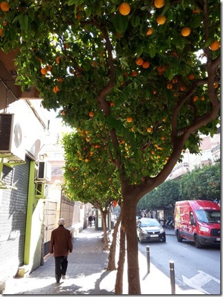
Oranges and lemons! Never have I seen so many! Our morning started by walking down lanes bordered by fields of lemon trees (which, incidentally, hold an awful lot of lemons per tree*) to the nearby village of Alquerias, where we caught a bus which took us along streets lined with orange trees to the city of Murcia, whose pavements are also the home to lines of orange trees, like this:
20160120_130017
We had a few things to see in Murcia so having located the cathedral…
20160120_113135
…and stopped for coffee/tea in the square from which the above photo was taken, we decided to leave the inside of the cathedral until later, due to my mistaken belief that it was open all day, whereas I knew that the furthest-away museum would close from 2pm to 5pm.
So, off we went to the Museo Arqueologico, which is somewhere I wouldn’t have been fussed about seeing if there had been an entrance fee, but as it was free thought we may as well have a quick look. It turned out to be surprisingly interesting, such that we spent a good chunk of time there, and undoubtedly would have been even better if we could have understood any of the displayed information. (Actually, there were an awful lot of words that even as non-Spanish speakers we could take a guess at, and thus we were able to get the gist of most of the exhibits, with Google Translate filling in some of the gaps when we were particularly intrigued by something.)
Purely based on their locations around the city we opted for the Museo de Bellas Artes next, where the first two floors, displaying 16th and 17th century renaissance art, really weren’t my cup of tea, but I did like the top floor, which was mainly 19th century.
By this time we re-emerged on the street, the bells were chiming 2pm and I was ready to eat a scabby dog, so it was back to the cathedral square for a Menu del Dia which we’d eyed up earlier in the day. Two huge mixed salad starters (I’m sure I’ve been served smaller salad main courses), the main courses shown below, a pudding each, a drink each, followed by a coffee each, all for €11 a head. I knew that there were bargainacious menus del dia to be had in Spain, but I’m still taken aback by the quantities.
20160120_142508
As you may be able to tell, the sun was shining as I took that photo at our outside table, and at the point that we sat down there had been no sign of the showers which had been forecast for today. Then it started to get a bit dark to the south and we’d barely dipped our spoons into our puddings when the rain started. Canopies were quickly deployed by the waiters and by the time we got onto coffee we were sitting in a fully enclosed outdoor room, complete with a heater. Within a quarter of an hour, the sun was back and stayed for the rest of the day.
Having lunched about 30 paces from the entrance to the cathedral, it was apparent that it was no longer open, scuppering my post-lunch plan. A double check of the guide book told me that I’d misread, and rather than being open all day it actually closes from 1pm until 6pm. It wasn’t going to be feasible to hang around (to have to walk the little roads back to the campsite in the dark), so off we went for a walk along the river before catching the next bus back. By way of some sort of public transport torture, on this perfectly warm day the bus had the heating on full blast, together with a temperature display to tell us we were sweating uncomfortably in a stuffy 26 degrees.
It was gone 5pm when we got back to Colin, finding that he’d been joined during the day by neighbours on both sides. Don’t they make him look tiny?!
20160120_171143
This Commercial Aire is split into two compounds and I’m calling ours the French Enclave, as that is the nationality of the majority of the occupants, with the remainder being one Dutch, one Belgian, one Irish and us.
(*some of those lemon trees also held oranges, we assume by virtue of some grafting having gone on, rather than by a freak of nature.)

Tuesday 19 January 2016

Tuesday 19 January – Sierra de Orihuela (Spain)

Whilst we were in the town of Orihuela yesterday (about 10km NE of the city of Murcia), we couldn’t help but notice the small range of hills just to the north of the town, and a visit to the Tourist Info Office furnished us with a free map, showing a handful of walking routes through those hills. Whilst none of the marked routes went up to the highest point, two of them hit the ridge sufficiently near to that point for me to think that there would be a trodden path to take us there, and thus a plan for today was formed.

Having spent the night in one of the car parks in the hills (more about that on t’other blog: thegateposts.blogspot.com), we were ideally located to get going this morning. In fact, there was our objective right before us out of Colin’s open side door:

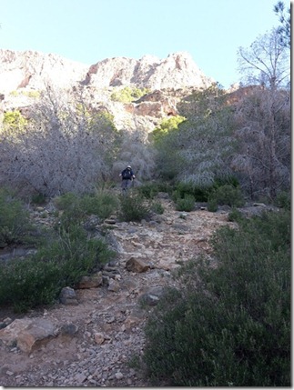
20160119_133205The going was pretty slow, mainly due to ‘plates of ballbearings’ type terrain with the occasional scrambly bit thrown in, but also, on the way up, due to navigational pauses. It turned out that there were various waymarked trails on the ground which weren’t shown on our map, and even though the signage seemed pretty detailed, we couldn’t find any of the placenames on our (small area) map. Fortunately, the 1:15k scale of that map meant that it was pretty straightforward to work out the correct directions based on the contour lines.

20160119_103716

Random snap of Mick heading up towards the col

Finally, just after hitting a col and heading up towards the ridge we found the name of our hill on one of the signs:

20160119_110122

IMG_0511

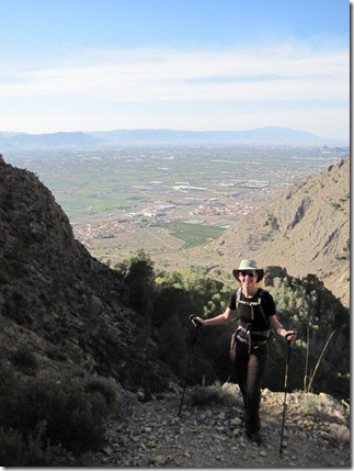
Random snap showing the plain below, which I think chronologically belongs before the waymark snap above.

Three identically dressed (right down to their baseball caps) chaps were met as we hit the ridge, from where we discovered that there wasn’t just the expected trodden line up to our top, but a proper waymarked trail and thus, via a couple of other pimples on the ridge, we made our way there, topping out at 634m:

IMG_0512

The views from the orange-peel littered summit (really, everyone who goes up there must eat a couple of oranges each, all discarding the peel) were superb, with vast plains below us, and other lumpy bits visible in various directions. In the direction this next piccie was taken, Colin was within view too, but even though I know his position, I can’t make him out on the photo:

IMG_0516

The downside of our start point was that it didn’t give the possibility of a circular walk, which didn’t really matter, as the route looked completely different from the other direction.

It was a fine outing, in perfect walking weather, coming in at 4.25 miles (taking us just over 3 hours; as I said, it was quite slow going terrain) with just under 600m of ascent.

Sunday 10 January 2016

We’re On Holiday!

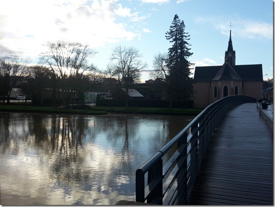
20160110_163927-001As I type I’m sitting in Colin at the edge of a river in France, at the start of a trip which will see us touring through bits of Spain (and, who knows, maybe Portugal too). Whereas usually our Colin trips get recorded in this blog, usually they are based around walking and thus I feel that those trips belong here. This is a touring trip, where walking is going to be secondary, rather than the main event. As such, I didn’t think my ‘what we did on our holidays’ posts really belonged on a blog entitled ‘M&G Go For A Walk’.

I will be wittering away whilst we travel, though, so if you feel inclined to see where we are and what we’re doing, you’ll find us at thegateposts.blogspot.com.

Sunday 3 January 2016

2015: Illustrated

It has become something of a tradition that I round up each year with some illustrated walking statistics, so here we go with a review of 2015.

The headlines are:

Total distance walked: 1522 miles*

Number of walks taken: 238 (77 entirely without Mick; 11 partially without Mick).

Number of days on which I went out for a walk: 191 (down from 227 last year). Some Marilyn-bagging days have seen me take multiple distinctly separate walks in the same day, hence this number being lower than the number of walks taken.

Total ascent: 272,736’ (my highest ascent year to date)

Average ascent per mile: 179’

Number of summits visited: 164 (compared with 66 in 2014)

Number of nights spent in a backpacking tent: 26 (down from 32 in 2014)

Number of nights spent in Colin the Campervan: 106 (up from 99 last year)

When I started looking at these stats I didn’t feel like I’d walked that many miles this year, but it turns out that the total of 1522 miles makes it my fifth highest mileage year out of the last ten (which is as far back as records stretch) and you can see in this pretty graph how 2014 stacked up against previous years:

image

This is how the miles mounted up on a month-by-month basis:

image

The lack of activity in June, September and for the first half of October is justified by other projects which were occupying all of my time. There is no excuse for the second half of October and much of November - I was just plain lazy.

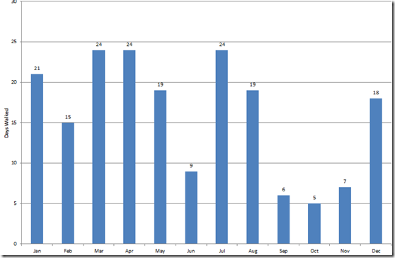
Sticking on the subject of ‘activity by month’, this chart shows the number of days I walked in each month:

image

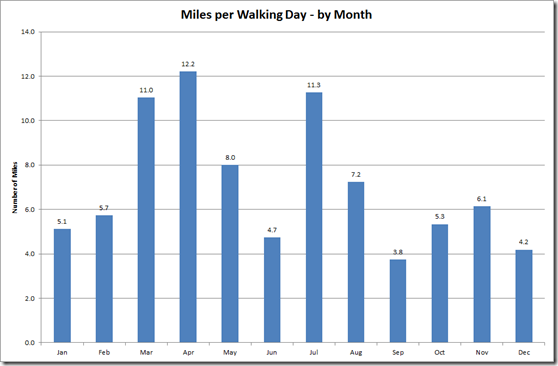
And to save anyone from having to do any sums here’s a graph showing the average number of miles I walked per walking-day in each month:

image

Rather a come-down from 2014 when a couple of my most active months saw me average 19 miles per day! Overall my average miles per walking day was 7.1, but if I take the year as a whole (including those days where I didn’t go out at all) then the average across the year drops to 4.2 miles per day.

Turning my attention away from miles walked to look at ascent, this is how this year’s record ascent compares to previous years (my ascent records only go back to 2008):

image

and this is how the lumpiness was spread throughout the year:

image

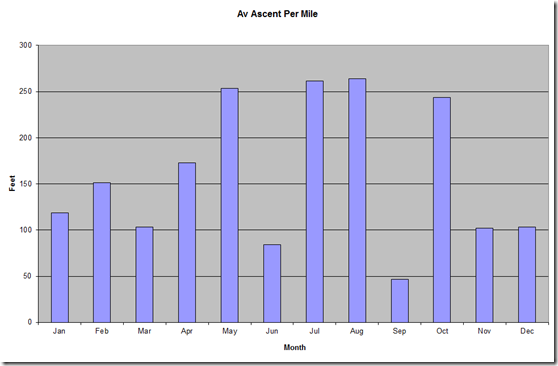
To be more meaningful, this needs to be looked at in conjunction with the ‘miles per month’ figures to give an average ascent per mile for each month, which results in a different shape of graph:

image

The stand-out months were May (Marilyn bagging in Scotland, whilst Mick was TGO Challenging), July (GR10) and August (hill-bagging in Scotland). October looks impressive, but that’s because of the 7 walks I took, four were to the tops of hills.

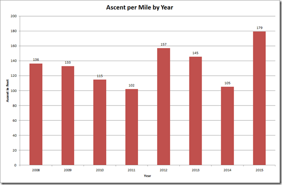
Whilst we’re on the subject of ascent per mile, this is how this year’s average stacks up against previous years:

image

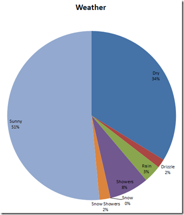
Being British, I’d best talk about the weather, hadn’t I? I’m not sure whether 2015 really was a good weather year, or whether this is just confirmation that I have become a fair weather walker, but 85% of my walks were completed in dry weather: image

I’ll include just one more chart (because I’m boring even myself now), and that’s the pie-chart of the shoes worn this year. A couple of pairs did get thrown away before the year was out, but a couple of new pairs were added to the extensive collection too, holding the total collection steady at {mumblecoughmumble}. Most notably, my Brasher Superlites went through 1000 miles on 30 December – which was one day before the left one ceased to be 100% watertight.

image

(*On top of the 1522 miles walked, my Fitbit tells me that I covered just shy of another 800 miles just in general everyday life, but those miles don’t count for walking stat purposes. Last year’s Fitbit total was only 550 higher than my ‘going out for a walk’ total; I think this year’s was higher in part because I did a lot of walking around the village streets to ensure that I met my Fitbit target ever single day (except the one day when I was too poorly to do anything) and in part because the steep ascents and descents in the Pyrenees saw me taking microscopic steps, making my Fitbit think that I’d walked further than I had.)

Just Testing

The fact that Windows Live Writer had ceased to function again, and in a more terminal manner than the incident a couple of months ago, somehow passed me by during December, only coming properly to my attention during the last week or so, when I haven’t had enough internet to do anything about it.

So, I’ve just splashed out on some data to allow me to download Open Live Writer as my customary “Illustrated Review of My Year” is overdue and it’s not a post I can put together via email (which puts all photos at the top of the post) nor is there any chance that I’m going to try to put it together via Blogger (which is just painful to use).

Alas, I’ve used so much data in downloading the necessary stuff that I may not have enough left for the post – but at least I can now put it together … assuming that this test works.

Of course, I need to test what happens with photos too, so here’s one of the mudfest of a track that we walked yesterday morning:

20160102_101830

Cringle Moor (NZ537030; 434m)

image

Like Round Hill on Urra Moor (yesterday's second Marilyn), the highest point of Cringle Moor sits a stone's throw away from the Coast to Coast route that we walked in September 2008. This time, however, I was sure that we hadn't visited the top by way of a detour, as we were in far too much of flap at the time, having just realised that we'd lost our map case, containing that and the next days'  maps.

This morning I was on a mission to visit that top, and even though I suggested that he should stay nice and warm and dry in bed, Mick opted to join me. As it went, by the time we'd finished drinking tea and organised ourselves to get out the door, the wind and rain had abated considerably from its overnight state, and whilst it wasn't a particularly nice day to be heading up a hill (we were in cloud, with a light rain falling, for the majority of the outing), it wasn't as wet and windy as we'd expected.

Having previously walked the Cleveland Way over the two lumps between Clay Bank (our start point) and Cringle Moor, I wasn't feeling any obligation to haul myself over them again - or at least not until I'd experienced the mudfest (interspersed with frequent boggy wallows) on the forest track which bypasses the tops. We duly cut back to the Cleveland Way having only bypassed the first of the lumps.

Arriving back at Colin 2.25 hrs after we'd set off (5.8 miles walked with 1700' of up), we found the car park about as empty as it had been when we'd left. Quite a contrast to yesterday – although who can blame people for choosing to go out on the crisp day of fine weather, rather than in the wind and rain?

Saturday 2 January 2016

Guisborough Moor and Urra Moor

In the middle of October, in the village of Dinas Mawddwy, I woke up to a heavy frost. It felt like winter had begun. Then ensued two and a half months of weather so consistently mild that not a hint of frost was seen and I often found myself walking in my shirt sleeves. Today, on the first day of the New Year, winter made a return visit, although I suspect it to be only a fleeting one again. So, it was with frost on the ground and puddles fully iced over that we set out up our first objective of the day.

Guisborough Moor (NZ634123; 328m)
image

There's a handy parking area just at the bottom of the track which leads to within yards of the top of this hill, albeit with a small off track detour required around a farm, making it a simple and fast going outing.

The views from the top included a little bit of sea and lots and lots of moorland. We could have explored that moorland further if we'd executed my original plan of a circular walk. However, with New Year's Day having the only decent forecast for the remainder of the trip I opted to forego circular walks in order to squeeze in two hills whilst the going was good.

This out-and-back came in at 4.5 miles with 500' of ascent.

Urra Moor - Round Hill  (NZ594016; 454m)

image

When I looked at this hill on the map I reckoned there was upwards of an 80% chance that we had detoured to it when we walked the Coast to Coast in 2008. It lies so close to the path of that route, and the trig point is so prominent, that it's the sort of detour we often make. However, as I had no actual recollection of going to that trig, and as we were going to be nearby, I thought we'd best visit it, just to be sure.

Having breathed in and squeezed Colin through the width restriction at the exit of the Clay Bank car park (the entrance width restriction looked a bit too tight for comfort), we took one of the two vacant spaces and set off against the flow of people. Being nearly 2pm by now, most people were heading back from their outings.

The wind was still biting and the ground still frozen as we ambled upwards, agreeing that very little of our surroundings looked familiar, even though we could remember the day we'd walked this way 7 years ago.

The trig atop the tumulus which sits at the high point of this moor didn't ring any bells either, although I wouldn't be hugely surprised if I was to go back to our photos from 2008 and find one of us there.

Making our return to Clay Bank we couldn't help but look over at our final objective of this trip, and knowing what the weather forecast held in store for the morrow, it was tempting to try to squeeze a third hill into the day. A look at my watch (where had the day gone?) and a quick calculation said that to do so would result in torchlight being required for the return leg. Wind and rain tomorrow, or torchlight today? I opted for the former and thus back to Colin we went with 4.2 miles walked with 800' of up.