The Road goes ever on and on; Down from the door where it began;
Now far ahead the Road has gone; And I must follow, if I can;
Pursuing it with eager feet; Until it joins some larger way;
Where many paths and errands met; And whither then? I cannot say.

[JRR Tolkien, Lord of the Rings]

Friday 29 June 2018

Strollling Around The Schwarzwald (Black Forest)

There just aren't enough hours in the day and that is why it's the end of Friday and I haven't yet penned anything here about Tuesday's walk, nor the two that came after. I did write a few paragraphs about them on the daily travel blog, so I'm going to cheat a little by not elaborating much, but by making liberal use of the words I've already written elsewhere. For those who read both blogs, I apologise for the repetition.

Tuesday - Triberg
It was afternoon by the time we arrived at Nußbach, just outside of overly-touristy Triberg, and it was a while later that I came to appreciate that we were within comfortable walking distance of the town. A 10.5km circular route from Bertie, into the town, coming back via the falls (Triberg is famous for cuckoo clocks, Black Forest Gateau, and for 'Germany's highest waterfalls' - 163m drop over 7 cascades) was downloaded and at about 2.30pm off we toddled.

Up through the forest behind us, then down the other side, we arrived in the town to find ourselves thwarted: entry to the falls costs €5 per head. We've seen a lot of waterfalls (indeed, in Norway last year it was a rare event if we parked somewhere and couldn't see at least 6 of them) and some truly spectacular ones, so we weren't feeling inclined to pay out €10 for a 0.5km section of our intended circuit, just because it contained some cascading water.

The route was a mix of forest tracks and paths, with some open meadows giving us views of the surrounding area.

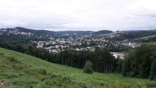
A viewpoint just before we dropped down to the town

View from the above

After a bit of aimless strolling around the town (lots of tat shops, lots of people) I pored over the map a while and worked out how we were going to re-route to pick up the return leg of our circuit.

Taken somewhere on our return leg

It was an easy, gentle introduction to the Black Forest and left us happy to see more of the region.

Wednesday - Stöckwaldturm
Schönwald sits only a small number of kilometres along the road from Triberg, but we found it quiet and untouristy and thus we had no problem finding somewhere to park Bertie for us to visit Stöckwaldturm (1070m), upon which sits a 19th century look-out tower - and a restaurant, although that was of less interest to us.

It was a lovely walk up there, largely through startlingly green meadows, dotted with picture-postcard chalet-style houses. The buildings captivated us as much as the green rolling meadows, with bits of forest all around (as you might expect in the Black Forest).

Such greenness!

It was the neatness of the garden and the design of the flower display that caught our eyes at this property

It wasn't until this house that we realised that the roof tiles that looked like slate were actually wooden shingles.

The light wasn't right for it to show up, but the roof of this tiny chapel had recently been re-shingled. The yellow will soon mellow to silver-grey.

A final section on forest tracks took us to the summit and the tower:

My snap didn't work, due to the position of the sun, so here's a photo of the postcard we were given upon payment of our €1 entrance fee for the tower.

One hundred and twenty four steps took us to the top of the tower, and the views were superb:


It wasn't just the view that occupied us as we stood looking over the railing: Mick set me some maths problems, so we stood there working out how long an object dropped from the top would take to reach the ground, and based on that the speed that one would be travelling at the point of impact, if one was to fall.

Maths problems completed, a longer route back to Schönbach was taken, such that we completed a circuit of 7.9 miles.

Thursday - Gütenbach and Simonswald

Our exercise yesterday morning started bright and early, helped by the local church having a policy of no one being allowed a lie-in beyond 7am (as Mick said at the end of the chimes: is it really 128 o'clock?).

Balzer Hergot was the first key sight of our 10km outing. I gathered the history simply from the pictures on this information panel:

In or before 1936 someone put a statue of Jesus here. Then the tree gradually ate it. Then in 1986 modifications were made to the tree so that it became framed instead.

Today it looks like this:


The second key sight came after we had dropped down, down and down some more into a gorgeous valley...


... when we climbed all the way back up via a wooded gorge.

This snap doesn't do it justice. The stream was a delight.


Not my favourite profile for a walk - I prefer to do the up before the down, but it was worth it (plus the pull back up was nowhere near as hard as the profile made it look).

Saturday 23 June 2018

Saturday 23 June - Stuttgart and Donaueschingen, via Böblingen

Where's Bertie? He's squeezed into a Stellplatz just outside of the town of Donaueschingen (exact location: 47.947451, 8.51218).
Weather: Mainly sunny, but still much cooler than a few days ago.

Last night's car park may not have looked ideal, either on paper or in reality, but it turned out to be the most peaceful place we have stayed yet this trip. An excellent night's sleep was had, until the alarm rudely awoke us just before 7am, so that we could relocate ourselves back to the ParkRun location.

The ParkRun at Stuttgart has only been going for 8 weeks, and today's Run Director explained the reason for the hilly course: they had requested permission to use the park in the middle of Stuttgart, but the authorities had declined not just the request, but any discussion as to what ParkRun was. They did, however, give permission for a lumpy woodland park on the edge of the city - which was a good location for us.

Joining 36 locals and tourists alike (England, Wales and Ireland were all represented today; at least two of the Brits had flown in purely to take part in a foreign ParkRun), I had an enjoyable run and was surprised as I queued to have my barcode scanned to have a lady ask me if I had been in Mannheim last weekend. Considering that I had a different outfit on today, and a hat (but no sunglasses), I was taken aback that she had recognised me.

My intention had been to go straight from the run to a laundrette, but instead we joined other runners for breakfast at a cafe a few km drive away. I wish I'd taken a photo of our breakfasts, which comprised a huge basket of various breads and croissant, a plate of ham and cheese and a couple of platters of butter and jam. That dealt with my hunger nicely!

The SatNav (and an inattentive navigator) took us very close to the centre of Stuttgart on our way to the laundrette and when we finally got there we could see as we drove past that it was busy, so when we couldn't find anywhere within half a mile to park, we abandonned our effort and cursed the distance and time the aborted mission had cost us (I say, as if we had anything more productive to be doing!).

Needing to make a quick decision as to where to go, I reset the SatNav for the motorhome Stellplatz at the town of Böblingen, only about 15km away. We did reach it, but doing so involved us having to go past some 'road closed' barriers, and mount a pavement to get around a railway-track-laying machine that was partly blocking the road at a level crossing. I felt reasonably confident that no work would take place over the weekend, but having established that the Stellplatz was at the end of a dead-end, and not wanting to risk being stuck there for an unknown period, we only stayed long enough to have coffee, decide where to go next and to use the free service point.

Donaueschingen (you should hear our SatNav's mangling of that name, particularly when 'Mitte' is added to the end, denoting that we should follow the signs for the town centre) was the next place I chose, through no scientific, or even informed, means. A 115km drive, almost entirely on Autobahn, ensued.

The bigger Stellplätze often seem to be busier than the smaller ones (I have a couple of theories as to why) and we arrived here to find this one full (although if everyone parked more tidily, at least 2 or 3 more would fit). We didn't drive off, however, but decided to shoehorn Bertie onto a worn-out verge in a position we adjudged would still allow the motorhome behind us enough room to exit.

Mick has walked into town since we arrived. I've turned a heel and picked up stitches for a gusset (I'm knitting the second trainer sock). In a little while we will walk back into town again and maybe see a bit of tonight's Germany game.

No photos today. I've not taken a single snap.

Friday 22 June 2018

The Crops of Güglingen; The ParkRun of Stuttgart

Just a very brief post to mention a couple of barely-worth-mentioning walks, mainly for my future reference:

Güglingen
We arrived in the small town of Güglingen, which sits between Mannheim and Stuttgart (Germany), on Wednesday, when the temperature was too high and the air too still to contemplate doing any exercise in between the hours of 9am and 8pm. Our exploration of the area, via the longest of the three advertised local routes, was therefore left until Thursday, when the temperature was a little cooler and the breeze much more in evidence.

It was such an exciting and inspiring walk, that I can't think of anything to say about it beyond the two paragraphs I posted in our daily travel witterings:

...we set off to walk the 10km circuit I'd downloaded from wikiloc.com yesterday.

That took us through a large variety of fruit and cereal crops (including lots of apples, blackcurrants and huge quantities of grapes), but it was all on tarmac. There was hardly any traffic (off the top of my head, two motorbikes and one tractor passed us), as despite the tarmac, most of these 'roads' were really farm tracks.

That's one serious picnic area! We grabbed the table in the shade for our coffee and cake, and repeatedly had to fish bits of tree/blossom out of our cups.

The elevenses view was mainly over vines

When the route became indirect in its latter stages, we cut short, as we couldn't see that the final distance was going to show us anything we hadn't already seen. Having started/ended at Bertie, and with a detour through the town on our way back looking for a milk-selling shop, we still managed to exceed the advertised 10km.


Stuttgart
Today's walk only gets a mention due to the amusement value of having set off to walk 1.5 miles by way of a recce of the ParkRun course that I intend to run tomorrow (only 1.5 miles because it's a two-lap course) and finding ourselves walking 4.2 miles before we were satisfied that we had found the right set of paths. We were left in no doubt that the track as downloaded from the ParkRun website is wrong - because what it shows is just not possible without bashing through trees/brambles/undergrowth - and that is not the ParkRun way.

The track as downloaded from the ParkRun website

What we walked before we were happy we had found the right route

Forutnately it was no hardship to do the extra distance, as the course runs through some very pleasant woodland. Unfortunately, I completely failed to take any photos, and it's highly unlikely that I'll pause mid-run tomorrow to do so either (hopefully I won't have to pause to catch my breath either, but it is the lumpiest course I'll have ever run).

Thursday 14 June 2018

Shapely Rocks at Echternach (Luxembourg)

Alternative title: Thwarted, Thwarted, Thrice Thwarted!

More often than not when we're travelling outside of the UK, we choose where to visit based on where there is overnight parking available for Bertie-the-Motorhome. Once there, we look to see what there is around that area. Sometimes an area is interesting and we stick around, sometimes there's nothing to hold us; sometimes we find a walking route (like yesterday) that is pleasant, but not spectacular, and sometimes we strike gold, like today.

After an early 4-mile, 2-circuit run around the lake just outside of the town of Echternach (which sits on the edge of the area of Luxembourg marked on our road atlas as 'Little Switzerland'), we relocated Bertie to a car park in the town and off we set to pick up our intended 17km route.

In the middle of a town is not where we most expect to find an interesting tractor. We particularly liked the addition of half an ice cream tub, wired into position under the bit of the engine that was leaking fluid.

Usefully today we came upon an information sign with a clear map setting out the walking routes in the area, from which we discerned that it was route E1 we were to follow. From a waymarking point of view, that turned out to be a very easy thing to do; this is a route so well signed as to make it suitable for people with no navigational ability or aids.

A steepish haul up a road out of town took us to a more level path that felt a bit like a levada walk in Madeira, except the drop off the side of the path wasn't big enough:


The first 'thwarted!' came when we reached a road with 'closed' barriers across it. Initially I didn't think this a problem, as we were to branch off just before we reached the closure, Alas, it was a problem, as the path was also barred:

As we had left town one of the finger posts had tape covering over the E1 finger, and another of the fingers had a diversion map. As that map said E4 at the top, I didn't pay it any attention. Perhaps that was an error!

A large group of ramblers turned back from the same point just as we reached it, and having briefly looked at our options, we followed them. We know not where they went, as at the first bench we stopped for a very early elevenses and to more closely examine our options. The decision: we would backtrack a little further, follow a path that would join up with our return route, and change the circuit into a lollipop.

That mainly worked, although we did soon come across another obstacle that was far trickier than this photo makes it look:

Four trees were down across the path, with branches, twigs and foliage everywhere. It took a while to find a path through, knowing as we did so that we would have to return the same way, and hoping that they hadn't also closed this bit of path by then!

It was beyond this point that the truly excellent bits of the walk began, in the form of shapely rocks:


Soon after we entered what was labelled as 'The Labyrinth', which I would compare loosely with Lud's Church in The Roaches, but with added twists and turns:


A little while later it became apparent that the path ahead of us had recently suffered significant water damage and when we had to cross a stream the bridge was missing (we later found it further downstream, lying uselessly high up along one bank), but with the water low, we were able to cross. We only covered a handful of paces the other side when the second 'Thwarted!' occurred:

This was a more significant issue, as it meant we couldn't access the westernmost section of the route.

We would have turned around at that point, except that the rock structures across the road looked too interesting to ignore, so we went for a closer look, and what should we find there...

...but a staircase leading up into a fissure. Clearly, we had to go up it:

It got a bit steep at the top, and the staircase became a metal ladder:


That led us to a viewpoint, on top of the rocks (in fact, on top of an overhang - gulp!), and having admired our surroundings from up there, it seemed that, having gained all that height, we may as well take advantage of it by adding in a loop of the next valley along which the E1 headed.

Alas, my intention to walk out along the E1 then return along the bottom of the gorge met with another 'Thwarted!'in the shape of another path closure, so we stuck with the E1 until it took us back to the road. There we discovered, by a glance to our right, that this road was closed too. However, we were already past the 'road closed' barriers, and hadn't passed any signage saying we couldn't proceed, so proceed we did. The reason for the closure became apparent: more flood damage has caused the road edge to collapse.

A workman took a photo of us as we passed him further along. Or maybe we were being paranoid and he was actually taking a selfie of his spectacular work location. Either way, nobody challenged us as we returned to our outward path.

Back through The Labyrinth, back over/round the fallen trees, a stop in a substantial lunch shelter, and onwards we went to the 'Gorge du Loup' - of which I failed to take any photos. It was a vast limestone wall with interesting layers.


This route is set up for the masses. There were benches and bins regularly, and a couple of big lunch shelters too. Due to the path closures, we had it almost to ourselves, encountering only 5 other people beyond the closed section (a group of three who commented how quiet it was, and a couple of dog walkers)

Just for the fun of it, we threw in an extra climb towards the end of the Gorge du Loup, when a sign told us we could climb another staircase up to the top of the wall, to a viewpoint. The viewpoint would have been a good one before all of the trees grew so big...

Down was then our direction, to regain the town, where this sign, outside of a school, caught my eye:

We often find ourselves bemused by European countries' adoption of English slogans

Even though we didn't get to follow the whole of the route, we still managed to cover 14km. I've no idea how much ascent was involved. Nor do I know how much more spectacular rock we missed, but if we should find ourselves passing that area again in the future, I'd be happy to stop by for a few more days to explore further.

Wednesday 13 June 2018

A Wander Around Wiltz, Luxembourg

As the title of this post suggests, we are away again in Europe. As always, anyone can see where we are at any time by nipping over to our daily 'what we are up to' blog at thegateposts.blogspot.com, but I will post here when we walk anywhere worthy of a mention. Having been on the road for just over a week, today was the first such outing.

The location was the town of Wiltz, which lies in the top third of Luxembourg - a country that neither of us had before visited. It's a very green, undulating area, with lots of summer meadows and woodland, and the route I had selected for today was described on Wikiloc.com as something like 'The woodlands and watercourses at Wiltz'.

Our route was the red one.

Based on the map (OpenStreetMaps - it's what we use for most of our walks abroad unless they are of a nature to suggest that a more detailed map is required), I had suspected that we would be in the trees for most of this walk, so I grabbed a couple of snaps early on when views presented themselves:


It turned out that we weren't nearly as hemmed in as I had expected, and even when we were in the trees, there were some clearings, including this one, covered in foxgloves:


Waymarks were plentiful...

...which might have been useful if we had known which, if any, we were trying to follow. As it went, there was no difficulty at all in following our route on the map.

There was, however, a little difficulty with two short sections of overgrown paths:

We battled through the first such section, but backtracked from the one shown above, feeling (quite literally!) that the number of nettles was incompatible with bare legs. It was easily bypassed via a road then a track.

The final section of the route ran parallel to the railway and a river, the former we had to cross a couple of times, the second time at a station. It was an odd place for a station, seemingly being beyond the end of the nearest road, deep in the forest, and with no haibitation around it. Curious.

Whilst nothing spectacular, it was a more pleasant outing that I'd expected, and a decent leg-stretch (9.5km, around 200m of ascent).

Wednesday 6 June 2018

Postscript to my earlier post

Earlier today I posted a photo of two cars jointly causing a dangerous obstruction of a road, as West Sussex Police's Operation Crackdown report form required me to upload the photos to somewhere on t'internet and to provide a link, rather than allowing me to submit the photos direct.

The acknowledgement I received in response to the report submission said that it was very important that the photo uploaded to somewhere on t'internet was not made public, because if made public it cannot be used in evidence. Key information that would have been better given at the point of instructing to upload the photo and provide a link to where it was located, rather than only imparting the instruction after the event (although in the absence of having an account at any suitable photo-holding website, all that prior notice of the requirement would do would be to stop issues being reported at all; not very user friendly).

As it goes, I'm almost certain that nothing will come of my report. I expect that only a requirement of access to the road by the emergency services would result in words being had with the drivers in question, and I sincerely hope that no such emergency does arise today.

As for us, thanks to Bertie's relatively slim stature (as A-class motorhomes go) we did get out and thus didn't have to move our Eurotunnel crossing, nor our appointment in Belgium tomorrow. A bit of careful measuring told us that the gap was 3" wider than Bertie. Some very slow guided manoeuvring ensued.

Mick took the job of steering and was patient enough to pause mid way out whilst I took these photos, to record our 'tightest gap we've ever had to squeeze through', although note that the photos were taken when Bertie's 'waist' was in the gap; his widest points are his wheel arches.

Obstruction Photo for West Sussex Police

West Sussex Police's Operation Crackdown requires all reports to be supported be evidential photos, but it doesn't allow photos to be uploaded with the form, instead they have to be placed somewhere on t'internet and a link provided. Hence this post. So, if you're not West Sussex Police you can move on to a far more interesting blog post.


(But just by way of a tiny bit of explanation: it's an inconvenience that we are currently trapped in this street (thankfully at a friend's house, not literally sitting in the street), it's far more of an issue, in an area with a high density of elderly folk, that access to the road is currently blocked for ambulances and fire engines.)