Wednesday 25 May (0835-1150)
Distance: 9 miles?
Weather: a couple of showers
There had been 30 tents at North Water Bridge, many of which had gone by the time we were making a move. In common with most of those that remained, we joined the rush to de-pitch as the edge of a shower blew through at about quarter past eight. It wasn't bad timing anyway as a few of us had agreed the night before that we would walk together to the coast and 8.30 was the start time agreed.
With Challengers ahead and Challengers behind, we were a party of six as we took to the little lanes heading roughly east.
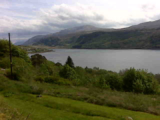
With only one break taken, it was just before noon that we headed down the steep cliff path (trying not to think about having to walk back up there afterwards) and across the beach to the sea. Amongst our number was Louise (www.gemini-challenge.blogspot.com) who was a first-timer. It was one hell of a Challenge for a first timer, what with the weather having been somewhat ... ummm ... challenging, which must have made it all the more sweet a moment to have reached the coast. Louise certainly had a very big grin on her face as she stood on the edge of the waves.
Disappointingly the tea room in St Cyrus is no more, but fortunately the bus service to Montrose is regular. A dozen or so people boarding the bus, complete with big rucksacks, and paying with £10 notes, did cause a bit of a delay to the service, but we were soon in Montrose.
Having signed in at Challenge Control, tea and biscuits were provided as we sat around comparing experiences with others there until the next wave of new arrivals came in, whereupon we repaired to the bar. A celebratory drink seemed to be in order.
There the conversation turned to the burning question: Where are you going to start from next year? And do you know what? Not a single person present proclaimed "Never again!". It's an addictive thing this TGOC!
Click here for TGOC Finish Photo
Sent using BlackBerry® from Orange
Friday, 27 May 2011
Day 11 - Tarfside to North Water Bridge
Tuesday 24 May (0715-1410)
Distance: 16 miles?
Weather: fine!
Distance: 16 miles?
Weather: fine!
Packing away took a bit of time, what with three people in a very small room and kit strewn everywhere, but we were away by quarter past seven. Along with Jon we were to walk alongside the River North Esk first to Edzell and then on to North Water Bridge. None of us had intended to go that way, but after 10 days of wearing waterproofs Mick and I had decided that our priority was simply to get to the coast via the quickest route.
That we had no maps for the change of route was a bit of an impediment, but with some trouble I had managed to borrow the right maps off people the night before and photograph the relevant sections (not that I would recommend relying on photos of maps, displayed on the small camera screen as an acceptable way of navigating!). The problem I'd had was that although most people seemed to be intending to go the same way, few of them were supposed to be going that way and thus the lack of the correct maps was a common problem.
Jon did have a map as far as Edzell though, and the route isn't complicated anyway. As long as you keep the river as close as possible on your left you can't go too far wrong.
Edzell is another of the notable places that features on many a Challenge. Everyone there seems to know about the event, and the Tuck-In tea room is a honey-pot. It would have been wrong to walk by without paying it a visit and after tea and lunch I enjoyed a most fantastic bit of fruit loaf before we set off again.
News had reached us at Tarfside that the bridge out of Edzell was closed, followed by the news that it was passable with care. When we got there the ends were blocked by barriers carrying big 'Dangerous Bridge' signs, but nothing actually said that it was closed, so the pen knife was put into use to undo some cable ties (without damaging them at all, I should add) and one by one we went across. The problem was that the support for one set of planks was missing at the far end, but whoever went first located the problem without falling through so we all got across without a problem (and I did duly replace the cable tie to secure the barrier once we were all through).
The walk down to North Water Bridge was then entirely unremarkable, being a few miles down a very straight road.
In common with the other days of the trip, as the day went on the wind speed increased and it was fairly windy by the time we arrived. Incredibly though, it was the first day of the trip when waterproofs were not required. A few light raindrops had been felt for a few moments earlier in the day, but as a complete contrast to the previous day, the weather was fine. So fine that on reflection our run-for-the-coast was unnecessary.
As the evening wore on and a chill came into the air, a few of us headed over to the games room and out came the table tennis table. It was there that Mick's Challenge could have come to a very embarrassing end. Moving across the table for a shot he got his Croc caught on the carpet and took a nose-dive to the floor. Fortunately he was uninjured, but can you imagine if he had been unable to complete the last 9 miles of a 925-mile walk due to an injury sustained playing ping pong?!
Sent using BlackBerry® from Orange
Day 10 - Stables of Lee to Tarfside
Monday 23 May (0735-1005)
Distance: 9 miles
Weather: Wet and windy
Distance: 9 miles
Weather: Wet and windy
It was a day that was entirely about the weather.
As a complete contrast to the wind speeds when we had gone to bed, at 2am all was completely calm and the skies were clear. The calm before the storm?
At 6am the rain was coming down and without even looking outside it didn't feel like there was going to be any value in delaying our departure. Whereas often we will wait to see if the weather improves, on this occasion we knew that waiting was only going to give us worse conditions.
We did count our blessings as we made our way down the track an hour and a half later. At least the wind was on our backs; the area was very pretty even though marred by rain; and we didn't have far to go. A hundred yards later we had to review that list. We hadn't changed direction, but suddenly the wind and rain was coming head-on.
With heads down, we marched along without even pausing for our customary faffs. There was no way that I was removing my layers of gloves unless absolutely necessary, and the camera had been carefully double bagged (pity I didn't do the same with the phone; in fact just sealing the single bag it was in would have been a smart move!). The only time we stopped was when we reached the car park 3 miles before Tarfside, where an information board is housed under a bit of a shelter. Stopping there required us to stand in a big puddle, but it gave us shelter for a few minutes for second breakfast.
The path from there to Tarfside features pedestrian gates with latches that have been fitted so tightly that they can't be opened, but it's a pleasant little walk behind the Hill of Rowan. Admittedly, we did abandon any idea of my intended detour up to the hill-top monument. We'll save that for another year.
Two and a half hours after setting off, with our thoughts with those who had much further to come, we arrived at St Dronstans, where I wasted no time in stripping off my wet stuff and going to enquire about a bed. We were in luck. At just gone 10am we bagged the last twin bunk-room (and, as it went, the penultimate room). We hadn't relished the thought of camping in the expected conditions.
Sitting drinking tea and eating cake, more and more people came in. There weren't many tales to be told for the first couple of hours (except by the girl who had been picked off her feet by the wind the previous afternoon and had a coming-together with a rock; she was sporting quite a black eye and a dressing). The walk in had been wet and breezy, but nothing wildly out of the ordinary. True to the forecast though, as the day wore on the windspeed increased and increased and increased. More and more people poured into the hostel in increasing states of tiredness and wetness.
With the place full to bursting (and no-one was turned away), the baked potatoes were just about to be put in the oven for the three evening meal sittings, when the power went out. It remained out for the whole of the rest of the time we were there. Top marks went to the volunteers who man the hostel for the TGOC for coping admirably in such adverse conditions and still managing to get everyone fed (and with a smile too).
Just before bed-time a health and safety announcement was made. The hostel has beds for 12 Challengers. There were 54 people staying that night (a number quoted by the lady in charge of taking the money, and she should know), and with no power there were increased risks. Even though the rooms were mostly only 6'x8', I think every one had a extra person, then there were the bodies in the conference room, the living room, the kitchen and the corridors.
It was certainly a memorable night, with bodies everywhere and wet gear hanging from every available place you could possibly hang stuff.
I had expected noise to go on into the night with so many people, but with the lack of electricity there were only a couple of options when darkness came: go to the Masons for a drink or go to bed. Most people seemed to go for the latter option and by just gone 10pm all was quiet (at least until the snoring started!).
Sent using BlackBerry® from Orange
Day 9 - Braemar to Stables of Lee

Distance: 20 miles
Weather: sunshine and showers
Do you remember how funny it was, back in your school days, if someone came out of the toilets unknowingly dragging a trail of toilet paper behind them? Well today I found that it's far funnier when a 50-something man accidentally walks the whole way across a campsite with his silk sleeping bag liner caught in the back of his trousers.
Unfortunately, I missed the incident itself, but when Mick got back from the shower and had his sleeping bag liner in his hand, I had to ask why he had taken it with him in the first place. It turned out that he had got the whole way over to the toilet block before noticing it trailing behind him. I cried with laughter at the very thought.
With the giggles subsiding I managed to pull myself into action and out of the tent into the sunshine. Yes - sunshine! It was so nice out that I opted for the windshirt rather than the waterproof.
By the time we set out the edge of a shower was upon us. Away went the windproof and for the ninth (out of nine) day of this trip I set out in my waterproof.
Having opted for our FWA, I had thought that we would be on roads for the first few miles of the day, but just before we set out noticed a track marked on the map. Directly across the road from the campsite a short yomp up the hillside took us to that track and it was a lovely little walk which avoided both cars and tarmac for the first couple of miles as we headed onto the Balmoral Estate.
Our route through Balmoral wasn't the one that I would have chosen, but it was the one that the Estate had asked Challengers to take. It kept us on good tracks, and it was more tracks that then took us all the way past Lochnagar to the Spittal of Glenmuick.
Lochnagar is the range of Munroes over which we would have walked, had we not opted for our foul weather route, and as we walked by at the lower level we rued the fact that we had believed the weather forecast. The clouds were not scurrying and the wind was lower than it had been for days. We clearly could have gone over the tops.
We consoled ourselves with the thought that by going low we were better able to position ourselves to minimise our time in tomorrow's forecast severe weather.
Lunch was had at the picnic area at the Spittal of Glenmuick (where, just as we were leaving we bumped into Steve and Linke, who we left at Corrour Bothy a few days ago; they'd just been up Lochnagar themselves), then off up to Sheilin of Mark bothy we went.
Many people have independently told us how tricky that bothy can be to find. Maybe it is on some approaches, but the way we went it was there as clear as day, easily seen from quite some distance.
It wasn't to be our night-stop, though, so we just popped our heads in for a look before, in the company of Jon who was headed to the same destination as us, we made our way up Muckle Cairn, down the other side and on to Stables of Lee bothy.
Only one other person was already here (inside the bothy), so we had our pick of camping spots. We wandered far and wide looking for somewhere good, until we finally settled for a spot right next to the track that runs in front of the bothy. Others have since arrived such that there are now five tents here (plus three people inside the bothy). Contrary to the earlier relatively calm conditions, the wind has now picked up. The tent across the track from us is the flappiest flappy thing known to man. It is certainly not a tent for these conditions. The others seem to be standing up pretty well.
We haven't spent the evening sitting listening to the flappy tent. A sociable evening has been had in the bothy where (uber-lightweighter) Jon whipped a Christmas pudding and a sachet of custard powder out of his tiny pack and very generously shared it around. It was by far and away the tastiest pudding of the trip. Christmas pudding will definitely be making it onto our packing list in the future.
And now the hour is getting late, so it's time to snuggle down, wondering how bad the weather will actually be tomorrow.
(Note: this post was typed at Stables of Lee. The following morning I drowned my phone and it took a few days to dry out. I will now see what I can remember about the following days and catch up on those posts.)
Click here to go to TGOC Day 10
Sent using BlackBerry® from Orange
Wednesday, 25 May 2011

Tuesday, 24 May 2011
Day 11 - stop press!
Just a quick update (can't be doing with much typing from Mick's phone) with the hot news of the day:
We walked an entire day today, from Tarfside to North Water Bridge, without needing our waterproofs! That's the first time in all 11 days of this walk! What a contrast to yesterday, in particular.
Still windy, mind.
As for my phone, once it has dried out completely I will see whether I killed it completely when I failed to seal its ziplock bag...
Monday, 23 May 2011
Technical hitch
Gayle's Blackberry has taken a thorough soaking and may not survive, so there'll be no updates on progress for a while.
With luck, it'll dry out and normal service will be resumed soon.
With luck, it'll dry out and normal service will be resumed soon.
Saturday, 21 May 2011
Day 8a - Braemar
What a miserable day. The consensus around town (and there are a lot of Challengers around town) is that the weather really is being a bit miserable for the Challenge this year. The wind has been up all day, and I haven't noticed the rain stop all afternoon. The blessing is that, today, we weren't out walking in it.
Just seen the Mountain Weather forecast for the next couple of days. Still persisting wet and windy, with Monday looking particularly bad (potential gusts, at times, of 90-130mph, it says!). There will be no more lumps on our route this year. We will now be wending a low route to the coast.
Click here to go to TGOC Day 9
Sent using BlackBerry® from Orange
Day 8 - Mar Lodge to Braemar

Distance: 8 miles
Weather: sunny intervals, one snow shower
Waking up in a proper bed, with the curtains still closed, I was able to lie there and imagine that it was a gorgeous calm sunny day outside. That's not what the weather forecast had predicted, and when I wandered down to the kitchen and looked out of the big windows there, I found that reality was that it was pouring down. "I'm not going out in that!" I declared.
Having been joined in the kitchen by Louise and Robert, breakfast became a prolonged affair as we all hoped the weather would improve.
Finally it did and by the time Mick and I stepped outside the sun was shining. That was a Good Thing, as it meant that rather than taking the four-mile road-walk into Braemar we could pop over Morrone of Morven (2818'). Even the wind didn't seem to be particularly strong - although that was perhaps because we were quite sheltered as we set out.
I don't quite understand what qualifies as being marked as a track on an OS map and what only qualifies as being a single-dotted-line path. The track we followed up the Corriemulzie Burn seemed to be a good obvious track to me, yet only qualified for the single dotted line. Admittedly it did degrade as it went further and, just as the map said it would, it gave out at about 600m.
There then ensued a knee-high-heather, very boggy yomp to get us onto the ridge, during which I did question myself as to why I felt the need to go over this big lump. If we had gone around we could have been sitting with a nice cup of tea and a slab of cake in a tea room, rather than wading through unavoidable bog.
Fortunately, whilst the ascent may have been a heather and bog yomp (and let's face it, we couldn't have expected anything else), we were reasonably sheltered on the ascent to the ridge.
Gaining the ridge we also gained a good track, but felt the full force of the wind, and that wind was strong.
As we reached the summit (which boasts excellent 360 degree views) showers were just coming in, so we took shelter (from the wind at least) behind the building at the top (this is a summit with a huge mast, and also the associated buildings). Incredibly, the shower missed us. As it reached the lump on which we were standing it split and went down the valley on either side.
With hands and feet freezing after just a few minutes up there, off we set back down. The next shower may also have missed the summit, but being on our way down it hit us. We didn't get wet, though, what with it being snow rather than rain.
The sun was threatening to come back out by the time we reached Braemar, where we (along with Louise, Laura and Robert, who we bumped into on the way) made a bee-line for the cafe for lunch.
And thus an afternoon and evening of socialising began, interrupted only by the need to pitch the tent and buy some supplies.
Having broken the walk from Corrour into Braemar into two days, we're now only a day ahead of ourselves, so tomorrow (Saturday) will be spent in Braemar, before we set back out on Sunday.
(Today's photo is of Mar Lodge, where we stayed last night. Not too shoddy a place for £15!)
Click here to go to TGOC Day 8a
Sent using BlackBerry® from Orange
Friday, 20 May 2011
Day 7 - Corrour Bothy to Mar Lodge

Distance: 9 miles
Weather: sunshine and showers (but we only caught the edges of them)
It was a dark and stormy night and the rain came down in torrents... (Hold on, weren't we here a few days ago too?)
I didn't notice the rain so much, as the bothy roof seems to be particularly well insulated (and the building doesn't creak or groan either), but you couldn't help but notice the wind whistling by. My thoughts were with Steve and Linke, who had arrived at gone 7pm (in the midst of a particularly violent squall) and, finding us in residence, had opted to camp outside. When they retreated to their tent after a sociable evening, my thought was that I wouldn't have wanted to be out there in that wind.
The weather had calmed a little bit by this morning (although still blustery), but we weren't moved to make an early start. There didn't seem much point with just a straightforward 9 mile walk ahead of us. I appreciated the lie-in too, as, in a fit of wakefulness, I'd spent an hour and a half watching the bothy mouse go about its business between 4.30 and 6am! Finally getting up at nearly 9am, we had another chat with Steve and Linke as they breakfasted and we packed up, then off we set under blue skies.
Continuing the theme of the last seven days, the sunshine didn't last, but today blue skies appeared often enough to set off the surrounding dramatic scenery nicely. There was even a fresh dusting of snow on the tops.
Derry Lodge is a magnificent house, now all boarded up, and it was there, exactly half way through our day that we stopped for lunch. It was an early lunch by our standards, but with the current constant hunger it was much appreciated. It was during lunch that we realised that the chocolate supplies had run lower than the acceptable minimum level. Rationing chocolate is not good! Sack the catering manager, I say.
The second four and a half miles of the day involved about 84 faffs, but even so we arrived at Mar Lodge by just gone 2pm. In our quest to lose a couple of days we had phoned yesterday morning to see if they had a room available tonight. As tomorrow is their busy night with Challengers passing through, a room was available and hence our 13 mile walk into Braemar was split into two days.
Mar Lodge is a magnificent place, owned by the National Trust for Scotland. So, not only do we have beds in nice surroundings tonight (and at a bargain price), but we've spent the afternoon drinking tea in the kitchen, where this evening appeared Robert (who we first met at Strathcarron) and Louise (www.gemini-challenge.blogspot.com). Much chatting has gone on this evening, comparing experiences to date, and a good time has been had.
But now it's late (too busy chatting earlier to be typing this). I won't post this until tomorrow, because to do so now would involve getting out of bed to walk down two flights of stairs to pick up the wifi signal - and I'm just too lazy to do that!
(I'm not sure how clear the photo is on a sensible size of screen, but the white thing in the middle, left of centre is Corrour Bothy)
Click here to go to TGOC Day 8
Sent using BlackBerry® from Orange
Thursday, 19 May 2011
Day 6 - Side Trip to The Devil's Point (3294ft)

Mick pouted and voiced his concern about me going alone. I, naturally, said that I would be fine. Mick pouted a little more, but didn't try to talk me out of the expedition.
On my way out of the door at 1530 (having emptied everything unnecessary out of my bag), I looked at my watch and said that if I wasn't back by 1800, Mick was to put tea on. Mick did a speedy calculation and exclaimed that I'd better be back by 1800.
It was sunny as I set out, but that didn't last ten minutes before the first shower came through.
It's a good path the whole way up, so even though the wind was strong indeed, the going wasn't bad. Then I got to the stream crossing at the top of the coire, and the wind, whistling through the notch, really wanted me off my feet. It was an interesting time getting across that stream.
The wind was even more determined to hamper me as I reached the col (I don't reckon the forecast was far out on wind speed), but by then I was close enough to the top that there was no question of not getting there.
Get there I did, and it was fantastic! The views were absolutely superb. Rain was obscuring the Lairig Ghru, but all other directions were clear for the few minutes I remained up there. As I saw the next shower approaching I headed back down.
That next shower was violent! Frozen rain hitting the side of my face stung, and at times I had to stop and turn to lean back into the wind to stop myself being blown away. I hurried to where I was going to drop down, knowing that I would soon get out of the very worst of the wind.
The stream crossing was worse on the way back, with the squall still blowing through, so I didn't even bother trying to step from stone to stone, I just sploshed right through. Then, blissfully, the wind was lower and behind me.
I sped down, reaching the bothy by 1700. Mick had seen me coming and had a cup of tea waiting for me :-)
It was a well worth while side trip that put a big grin on my face, but it did confirm, if confirmation was needed, that winds gusting to 50mph and above are too strong for a wee slip of a girl to be wandering around on hill tops. I certainly wouldn't have wanted to have spent miles battling that wind!
Click here to go to TGOC Day 7
Sent using BlackBerry® from Orange
Day 6 - Coylumbridge to Corrour Bothy

Distance: 13.25 miles*
Weather: showers, some quite violent
I have long wanted to walk through the Lairig Ghru, but it hadn't fitted nicely into any of our walks to date. One of my two starting points for planning this year's TGOC route was therefore that we had include this legendary pass.
With such a long held desire to walk this way, if we were only to have one day of good weather on this entire 2-week walk, then I wanted it to be today.
Perhaps a bit perversely, given what I've just said, when yesterday afternoon turned out to be calm and dry with clear tops we had a rethink. As much as I wanted to do the Lairig Ghru it seemed a shame in such weather not to go higher. We decided that, if the weather was still so good, we would go via Ben Macdui and when we called in to report our progress to Challenge Control we told them of the plan. They told us in return that it was possible that some bad weather was going to come in overnight.
Later we saw the Mountain Weather forecast. 35-40mph winds on the tops, gusting 50-65. Harrumph. I clutched at the straw that the forecast was wrong.
All was calm when we left the campsite this morning (admitted the campsite is very sheltered), and although showers were passing through the tops were mainly clear. I was optimistic.
By the time we reached the point where we needed to branch off if we were going for the tops we were battling against a headwind and being lashed in our faces by rain. The Lairig Ghru it was then!
The wind did make it a bit of a challenge, sometimes stopping us in our tracks, but the heavy rain only lasted for twenty minutes or so, and in between the passing showers we could see all around us. Impressive it was too. Spectacular in fact. From the stream running down the middle, to the steep hillsides either side and the boulder fields we had to cross, there was much to admire (at least when we weren't hiding under our hoods, looking at the ground).
Reaching a stone windbreak at 800m, just before the top, the decision was made to stop for lunch, even though it was only 1230 and even though we'd only had elevenses half an hour earlier. It seemed unlikely that we would find shelter again until we reached Corrour Bothy (still 4 miles away) and the sun was shining...
... we had just got our packs off and our lunch out when it started to rain. Back away went the lunch and back on went the packs. Lunch could wait.
Plenty of other people were seen as we popped over the top and came down the other side. Most people commented on the wind. Did I mention that it was quite noticeably strong?
We reached Corrour Bothy at 1435 and, being our intended night stop we made ourselves at home, got a brew on, had some lunch and were looking forward to a lazy afternoon. Or at least, that was the plan...
(*anyone who has walked from Coylumbridge to Corrour Bothy might think "but it's only 11.75 miles between those two places". They'd be right, if you take the direct route. We intended to take the direct route, but somehow both of us managed to miss completely a turn we needed to take in Rothiemurchus Forest and, blindly following a good path, didn't even look at the map to notice the omission until a good mile later. As such, we took a longer route via Rothiemurchus Lodge.)
Click here to go to TGOC Day 6 Side Trip
Sent using BlackBerry® from Orange
Tuesday, 17 May 2011
Day 5 - Coignafeuinternich Ruins (River Findhorn) to Coylumbridge

Distance: 18.5 miles
Weather: couple of drizzly showers, otherwise dry. Some sun!
(I've noticed that I thought that both Sunday and Monday were the 15th of May; I think I've got the right day and date today!)
Today wasn't as spectacular as yesterday, but that's just a comparative thing; it was still jolly pleasant. Even better, by noon some blue patches had appeared in the sky and the sun came out a few times!
Having got ourselves a bit of an early start (not by design, I just happened to drag myself out of the snuggly sleeping bag more promptly today), off we set to pick up a track about half a kilometre from where we had camped. To our surprise we found a path leading us there. A long disused track by the looks of it, but with no indication of it on the map.
As keeps happening, we got to a point where there appeared a new track that wasn't on our map. Not knowing where it went, we followed the direction we needed, only to find after a climb that the new track would be useful to us after all (if we went a slightly different way), but that we needed to descend and re-ascend to reach it.
That track sped us a good way upstream before it ended, leaving us with just the final yomp up to the pass. Peat hags were again the name of the game as we crossed over the top, and today they were a little less friendly than yesterdays, being more oozy with fewer firm bits, but they weren't overly hostile and we found our way through. The burn we picked up on the other side was pretty indeed and once again would have offered any number of lovely waterside pitches. We became quite familiar with that burn too, as the best route down it involved crossing the water rather a lot of times. Sometimes it was just a step, sometimes a little jump and latterly a matter of picking some likely looking stones to ease us across dry-shod.
Near to where our little burn joined the River Dulnain we figured we may just as well cut over the hillside instead of taking two sides of the triangle. It was whilst stepping through the heather there that Mick nearly trod on a grouse. A quick peek from where it had flown revealed six eggs (which will be why the mother was trying to stay put even with boots almost upon her), but we quickly moved on to allow her return to her task in hand (wing?).
I had plotted for us to take to the east side of the River Dulnain, but having cut across the last corner we were committed to stay on the west side, which turned out to be a good move. The walking was firm and easy; the other side (where the map shows a path) didn't look so good. In fact, the walking on the riverside was so good that for a while we ignored the track (another apparently non-existant one), which had appeared above us.
The track, when we joined it, took us to 'The Red Shed', a bothy (complete with a rocking chair!), where a cup of tea was brewed and elevenses had. The bothy book revealed that another Challenger (Kim, with whom with finished in 2009) had passed through two and a half hours earlier. We had heard last night that he was nearby.
The bothy isn't a bad place, and a few years back must have felt very remote. Now it's at the junction of many new tracks which have been unsympathetically built, scarring what would have previously been a largely unspoilt landscape.
As much as we might complain about how offensive such tracks are on the eye, we were quite happy to take 'The Burma Road' - another eyesore of a track. It took us the whole way up to 700m, and then all the way down the other side of the hill, to just down the road from Aviemore. I did point out to Mick when we reached the top that we only needed to go up another 125m (and across about a mile) to bag the Corbett that lay just to our right, but Mick didn't much fancy the extra distance (and I had my mind on getting to our destination early enough to do some washing), so down we went.
A bit of a detour was necessary to pick up some food in Aviemore, where we bumped into Kim, who it turned out is also staying at Coylumbridge tonight (and who hadn't been able to resist the Corbett, which explained how we'd caught up with him). With bags heavy with food, down the road to the campsite we toddled, where we are now pitched on the bare earth of the forest floor, there being a distinct lack of grass on this site.
My fingers are crossed for good weather tomorrow. It's the day of the walk where I really *really* don't want to have to take the foul weather alternative.
Click here to go to TGOC Day 6
Sent using BlackBerry® from Orange
The Landscape and The Wildlife
Maike left a comment a couple of days ago, asking a couple of questions which made me realise that I've been concentrating on commenting on the terrain, its ease of passage and the weather. I've described the effort involved in the walk, but not the rewards - which has been remiss of me as there are rewards aplenty.
Happily, even though the weather has been a little on the wet side, visibility has been good (except when a shower is approaching or upon us, when it decreases until the shower has passed). So, except for parts of yesterday when the cloud came down to 800m, we have been able to see the tops. Some of our visits to the top of lumpy bits have afforded some extensive views too.
Whether we have been walking along glens, down streams, across passes or over little lumps, it has all been quite lovely. The scenery of Glen Strathfarrar is incomparable with the heather/bog of, say, Eskdale Moor, but both have their appeal.
As for the wildlife, there is lots! It would be unusual to walk through these parts of Scotland for a day and not see deer, and we have been seeing plenty. Then there were the wild goats yesterday and three mountain hares today.
I can't name most of the birds that we see, but there are lots. From the LBJs (Little Brown Jobs) to the ubiquitous grouse, which startles you every time as it take off from a few feet away from you, whilst cackling loudly. Over the last couple of days lapwings have been making their presence known too; I think that we may have strayed close to a nest site or two. Alas, we didn't catch sight of the eagle by last night's pitch.
Sent using BlackBerry® from Orange
Day 4 - Drumnadrochit to Coignafeuinternich Ruins (River Findhorn)

Distance: 20.5 miles
Weather: showers, some prolonged, but all very light; very windy at times
What a tremendous day! Admittedly it didn't start entirely to my liking. I don't do boats, and (after a 2.5 mile walk from the campsite) we had a half-hour crossing of a choppy Loch Ness to make. I thought it was okay as we approached Urquart Castle, then we rounded the headland and it all became a bit bobbity.
Chatting to the other four Challengers on board distracted me, and when we got back onto dry land the other side we set off as a party of five. Five dwindled to three and for a few miles we walked with a chap called John (he did try to shake us off a few times, but circumstances kept conspiring to get us back together).
A little bit of a meal was made in getting past Dumnaglass Lodge (Vic: that's Sir Jack's place) then just beyond we caught John again just as he was frantically searching about his person. It turned out that he'd lost his map. He knew where, but wasn't moved to return to find it, so we all rumaged in our bags, John & Mick for spare maps and me for a spare A4 bag, before we all set off again.
A track was followed for the next 3.5 miles and, my goodness, it was unrelentingly steep at times. At least on the steepest parts the wind wasn't head on. We'd been battling against it earlier. Those steep bits would have been dreadful with a strong head-wind, particularly as it had started to rain too.
The top of the track was reached at sometime after 2pm, when it felt like lunch was long overdue. Lunch would have been quite unpleasant there, in the wind and rain, except that at the end of the track is a large wooden hut where we were able to get shelter, to brew up, and to have lunch. It was a good long break.
Whilst the morning (using the term loosely; I mean 'before lunch') had been in perfectly pleasant surroundings, it was the afternoon that really stood out. It was absolutely stunning.
It was a touch of a boggy yomp up to a pass (the highest of the trip so far, at a smidge under 2500'), but once we got up there the view opened out and there was absolutely no sight of anything man made. Just the folds of the land and the cuttings of streams.
Peat hags had to be negotiated along the line we needed to take, but they struck me as being particularly friendly hags, which didn't make us have to meander around too much.
The part that really took our breath away for sheer beauty was the Allt Odhar Mor. The stoney-bedded stream ran at times through a deep cutting, but along its entire length was a very generous quantity of perfect flat, firm grassy pitches. We knew that if we didn't find a good pitch at the end of our day then we would rue not stopping there.
Unbeknownst to us, the beauty of that stream was going to be equalled by the valley through which runs the River Findhorn. Absolutely stunning, once again.
Shunning the million potential pitches in the valley (scant exaggeration), we continued along having startled and then chatted with another Challenger called Jane. A few minutes later, we caught sight of the deer - a couple of hundred of them, which were streaming off the hillside to graze on the plain. Then we spotted a good handful of wild goats too.
The deer took fright as we walked past, but soon came back as we turned off up a side valley. By the time we pitched the tent they were all back within our view, and what a wonderful sight it was.
We're now camped just up that side valley, just along from another Challenger, who we've seen daily. He tells us that an eagle frequents this area too. We'll keep our eyes peeled.
Well, I think I've rambled on enough for one day, so I'll shut up and ponder some more on what an incredible day we've had (it's almost a good job the weather wasn't up to scratch - I would have run out of superlatives!).
Click here to go to TGOC Day 5
Sent using BlackBerry® from Orange
Sunday, 15 May 2011
Day 3 - Eskdale Moor to Drumnadrochit

Distance: 12.5 miles
Weather: showers, some prolonged, but mainly v light
My image of Eskdale Moor had been one of heather, bogs and tussocks for seven miles. With no paths or tracks marked on the map, I pictured one of those hard-going yomps where you have to pick the foot up to knee height on every step. I had estimated that we would cover one mile per hour.
Off we set from our campsite this morning ready for a hard day, and immediately decided to make it even harder by going over a series of lumpy bits that lay in our way, rather than taking my plotted line around them. The thinking was that it would be drier if we went higher - plus the climbs might serve to get some blood into my fingers and toes.
We were indeed soon warmed by the climbs, and also pleasantly surprised that the going wasn't as hard as expected. The heather was deep in places, but it wasn't overly tussocky, nor was it as extensively waterlogged as anticipated. In fact, I only filled my (mesh topped) shoes with water three times all day, rather than on every step as expected.
Once we had reached Loch Neaty (two miles in) the going became easier for the next mile (if you ignore the two deer fence clambers) as not only had we cleared the lumpy bits, but short grass prevailed for a while, followed by some vehicle tracks. At Loch Bruicheach the vehicle tracks joined a made track. Now that was unexpected!
It might have been that the made track would have carried us to where we wanted to go, albeit via a round-about route, but it seemed to go off in the wrong direction. Instead we followed the shore of the loch, which for a chunk of its distance involved thigh high heather and bilberry. I only lost a leg down a deep hole once (and it was accompanied by a very girly 'oooh' sort of a squeal).
A pipeline was the leg-saviour for the next chunk. A water pipe has at some point been buried, running exactly where we wanted to go, and on top of its line the heather hasn't yet taken full hold again. The going was still rough, and at times steep, but it was certainly more comfortable than another mile and a half of heather-bashing.
When we finally picked up a track, which according to the map would take us to the road into Drum, we thought that the hard part of the day was behind us. It should have been too, except that we got completely discombobulated when things on the ground didn't match the map (did I mention that I need to update my mapping software?!).
To and fro we went, until we gave up on our intended line and re-routed. Even that wasn't plain sailing, and ended with a bit of a bash down a hillside. We got here in the end, though, and discovered another Challenger sitting on the green, killing time before the boat ride across the loch.
We will be taking that ride tomorrow, but for today we popped up the road to the campsite, where the replacement Thermarest NeoAir was waiting, and where we have enjoyed much needed hot showers.
As I type this, we're ensconced in the Loch Ness Inn for tea, where the food has been recommended.
(Note: Mick says that I've made the day sound easier than it was. He'd like it to be known that it was a day of heather and squelch and that it was quite hard going. I don't disagree with him. It's just that I expected boggy heathery hideousness, and it wasn't as bad as I'd imagined.)
(Hannah - we did eventually get a cup of tea last night. Also realised that I didn't answer your previous questions: this year we're both using Osprey Exos 46 litre packs, which are significantly bigger than the OMM Villain 45 that I usually use (fortunately, I haven't felt the need to fill the extra space!). As for ticks (which I'm still removing from myself daily) I use the tweezers off my little Swiss Army Knife. They get under even the tiniest of ticks and seem to do the job nicely.)
Click here to go to TGOC Day 4
Click here for 'The Wildlife and the Landscape'
Sent using BlackBerry® from Orange
Day 2 - Gleann Innis an Loichel to Eskdale Moor
Sat 14 May (0945-1755)
Distance: 18.5 miles
Weather: sunshine and showers, some heavy
Distance: 18.5 miles
Weather: sunshine and showers, some heavy
It was a dark and stormy night and the rain came down in torrents, and at about 3am (as I waited for a break in the rain to allow me to pop out to the en-suite and to check the pegs) I concluded that our high route wasn't going to happen today. It was the wind that convinced me so.
At 6am, our usual early start was also not going to happen. The rain was still coming down with a vengeance and the wind was still making its presence known. We rolled over and went back to sleep. Eventually, concluding that we weren't going to get very far if we didn't get up, we made moves towards packing away. By the time we got going it was knocking on for 10am.
Frank, who we left finding a pitch for his tent just after Loch Monar yesterday (about 2 hours before we stopped), didn't have a lazy start to his day. As we headed back to the track this morning, he was just passing. We soon caught up, and walked with him until he turned off towards Cannich.
Our route was rather less interesting than Frank's (we'd walked that way back in 2008). In the absence of our planned Munroes we were simply heading along the glen to Struy. It is a lovely glen, but it wasn't the most exciting walking.
So, to make things more exciting we decided to shun the good pitches along the glen and head instead onto Eskdale Moor, where (expecting heather, bogs and tussocks) we were far from certain of finding a pitch.
Getting onto the moor was made even more interesting by the fact that there's currently an access issue with the track that we wanted to take (the issue being that the land owner has barred its use). Rather than detouring to the next track we opted to head directly uphill through some woodland, which worked well - even if it did involve climbing 3 deer fences (for anyone not familiar with walking in Scotland, deer fences are wire fences about 6 or 7 feet tall, and they're not the sturdiest structures to scale whilst wearing a backpack). Fortunately, in spite of the deer fences, there were good deer trods to follow, which made our steeply-uphill-yomp easier.
Having reached a little loch it didn't look promising for a pitch, but after a bit of poking around Mick came up with a tent-sized patch of flat, not-waterlogged and nearly level ground that's doing the job nicely. It even has a slight view of the loch. No sooner than we had the tent up than the rain started and in we dived. Three quarters of an hour later, as I type this, we're still waiting for it to ease off so that we can go and find some water for tea and a cup of tea. I'm sure it hasn't rained this long at any other point during the day!
Looking at our route sheet I see that we are now where we should be at the end of Monday. I think we need to slow down a bit. There's not much point in choosing a sociable route and then getting so far ahead of ourselves that we don't meet anyone.
Click here to go to TGOC Day 3
Sent using BlackBerry® from Orange
Saturday, 14 May 2011
Day 1 - Strathcarron to Gleann Innis an Loichel

Friday 13 May (0815-1750)
Distance: 19 miles
Weather: showers, but more dry than wet
Unless my memory is being selective, I think that, even though today was far from our longest mileage day of the trip, it was the longest day's walking in terms of time. We only had about an hour's worth of proper breaks too (i.e. stopping for a rest and some food, rather than just pausing for a faff).
The day started after an excellent night's sleep and a good cooked breakfast, when we signed out on the TGOC Register and set out in dry weather (and without even the sight of a shower heading along Loch Carron).
Up was the theme of the morning (unsurprisingly given that we'd started the day at 10m above sea level), and along a path we sploshed in the direction of Bendronaig Lodge. The Lodge has a private bothy, and being 6 miles into the day it seemed like a suitable place to aim for our first break.
It was as we sat there, fending off questions from a very enthusiastic chap walking a meandering route up Scotland, that we looked at the map and spotted the route that I would have chosen had I noticed it at the planning stage.
We ummed and arrred as to what to do. The route we'd spotted didn't feature on our route sheet at all, but did have two points of significant appeal: 1) we'd not walked that way before; and 2) it avoided some stream crossings that I expected to be, at best, dodgy.
It was the latter point that swung the decision and off in the 'wrong' direction we headed.
A while later we caught up with Frank, who we'd spoken to earlier, who must have wondered about our navigation skills. Earlier we had told him where we were headed yet now were somewhere different entirely. We didn't get to explain at that point, though, as we caught up with him just as he headed off upstream to find somewhere to cross a burn, whereas we just sploshed across on the track.
There seemed little value in trying to keep the shoes dry when everywhere was so wet anyway. A few miles later, when the track we were following ended, the bog and standing water was certainly unavoidable.
The wet theme continued too, as we embarked on a yomp over a pass, but to our joy after some hard-going terrain, the marked path on the other side of the pass did exist and sped us towards our intended night-stop.
Our night-stop got shifted onwards by another half a mile when a shower hit just as we were ready to look for a pitch, and by the time we found somewhere further down the valley the next shower was in sight too. The pitch isn't the flattest. In fact, we're pitched on a mole-hill, but having thrown the tent up before the rain came we've decided not to move it. It may have a lump, but it has other redeeming features: a river just below us, and a bit of a view.
We now find ourselves reasonably well placed to go high tomorrow, if the weather in the morning should look promising enough to allow it.
Quite a pleasing first day, all in all. Moreover, as the weather allowed us to appreciate some stunning scenery (freshly dusted tops too; it seems that last night's rain fell as snow high up).
Click here to go to TGOC Day 2
Sent using BlackBerry® from Orange
TGO Challenge - Day 0
We seem to be making a bit of a habit of moving the tent after pitching but before going to bed. Last night we did so again - but in a good way.
A bus and a train had delivered us, by 3pm, to a few paces away from the Strathcarron Hotel, which was to be our sign-out point for the TGO Challenge. A few hours were then spent chatting with Messrs Sloman and Walker (the only people in the bar at that point) until eventually, after a bowl of delicious Cullen Skink, we decided that between the next two showers (which were passing through every few minutes) we ought to go and pitch the tent.
With the next shower almost upon us by the time the tent was up, we didn't spend any time arranging our living quarters. Postponing that till later, back to the bar we went.
Another hour or so passed, without even a vague thought of 'we ought to go and sort out the tent', when the unexpected happened. When we had arrived Mick had asked whether we could be on standby should the hotel have a cancellation. With 38 Challengers starting there and only 11 rooms, it seemed highly unlikely, but at some time after 8pm it came to pass that we were offered a room. We didn't need asking twice.
What a room it was too! All we then had to do was to wait for a break in the rain to dash out to move the tent from outside the hotel to inside our vast bathroom to dry overnight.
With lots of people in the bar, lots of chatting took place, and it was long past my bedtime (admittedly my bedtime is usually rather early) by the time we toddled off to our sumptuous room, ready to start the Challenge in the morning.
Click to go to TGOC Day 1
Sent using BlackBerry® from Orange
Wednesday, 11 May 2011
Kit Casualties - Part 2
This really will be the walk remembered for kit falling apart and wearing out. In addition to the previous list:
1) My Icebreaker 150 s/s t-shirt. A case of wear and tear, rather than a failure. The hole has been sewn up and it should make it through the next two weeks.
2) My Terroc 330s. Brand new when we set out from Inverkeithing, they'd done fewer than 100 miles when some of the stitching came adrift. To be fair, it's possible that I caught it against a rock, or something. The cut of the shoe is such that I was able to get a needle in to sew it back up through the original holes.
3) My backpack. Possibly the most annoying of the casualties. Bought new immediately before this walk I expected it to look almost unblemished at the end of it (not unreasonable, in that Mick's identical pack has 2000 miles on it and isn't in bad shape). I now have three holes in the mesh back (one where stitching has come undone, two where the hip belt has rubbed) and some stitching has come undone on the collar. That will be going back once we're done.
4) A Platypus 2-litre water bladder. It's failed exactly where its predecessor did, where the opening is attached. I didn't get around to sending its predecessor back, but I intend to return this one, because its really not old enough to put it down to wear and tear. With a leaking bladder being rather inconvenient, we'll be buying a replacement before we leave Fort William.
4) Mick's windproof. The saddest loss of the trip and undoubtedly a case of wear and tear. This Montane Featherlite started from Land's End as a bright yellow jacket. By the time we started from Kent it was very faded, but you could still tell that it had once been yellow. By the time we started out from Lowestoft it was faded to nearly white. It was just four days from making it through all the points of the compass (not to mention having had successful trips across England, Wales and Scotland and countless other trips and runs) when Mick went to put it on, only to have an arm become significantly detached from the body. The jacket still made it through to the end, and the sewing kit will again be called into action before we leave Strathcarron in the hope that it can be cobbled back together sufficiently to make it across Scotland.
5) The tent. Pending arrival of Vera's flysheet, in Fort William we invested 99p in a flimsy plastic dust sheet. Up went the inner tent, the dust sheet was flung over the top and then on went the leaky fly. The weather obliged us with showers every few minutes all the way through the afternoon and, judging by the standing water on the campsite yesterday morning I'd guess they continued through the night too. At 8am in the morning there was just a single, small drip of water sitting on that plastic sheet. Curious! As we sat there pondering why it had leaked so badly two nights earlier, the dripping started. By the time we packed away at noon quite a bit of water had made it through the flysheet seam - but thanks to that 99p dust sheet, we were dry inside. It's not a long-term solution by according to Royal Mail the replacement fly is waiting at Glen Nevis for us.
6) Mick's Thermarest NeoAir. It has always had a slow leak, but now some of the air chambers have become detached from the outer, so it has bulges appearing. Interestingly, the detachments started exactly on each of the fold points (where you have to fold it to put it in the supplied stuffsack). That will be returned under the lifetime guarantee when we get home too.
7) My jacket. My Montane Venture jacket had been worn once before we set out in March and, thanks to the stunning weather, has seen very little action on this trip. So, it's disappointing (but not a considerable inconvenience, and easily fixable) that a matching pair of velcro tabs on the main zip cover have come off.
8) Mick's gaiters. I mentioned these on the last casualty list, when some stitching came undone. They've now worn holes in them (and on mine some of the material has delaminated). They're Raidlight Debris Gaiters and from the short life of both of our pairs we have to conclude that they aren't anywhere near worth the money they cost.
Think that's everything for now. Wonder what will break next? (Hope it's not me or Mick!)
Sent using BlackBerry® from Orange
Sunday, 8 May 2011
Day 42 - Resipole to Ardnamurchan
Sunday 8 May (0700-1605)
Distance: 26 miles (Tot: 746.5)
Weather: wet until 2pm, then increasingly fine
Number of herds of deer seen: 1 (significant as, incredibly, they're the first we've seen)
Number of old dears mugged: 3
Today we completed all of the points of the compass!
The plan hadn't been to achieve that until tomorrow, so to explain how it came about I'd best go back to last night and the issue of the leaking tent.
Just to clarify: when I said that the tent was leaking I didn't mean that we had a little bit of seepage. What we had was water dripping through in any number of places. It wasn't a catastrophic failure (and Mick was quite right when he told me that we'll look back and consider that it was all part of the adventure), but quite how it went from vague seepage in 2 places the night before to significant leaks all over last night, I don't know (although last night's rain was absolutely torrential at times).
Having sat with torch and J-cloth during the night time showers (which, with a lack of wind, took ages to pass), there was a distinct lack of sleeping going on.
There were far worse times that the leak could have occurred, in the scheme of things, but even so, we found ourselves on an almost- serviceless peninsula with a failing tent. It seemed like the best thing to do was to get the walk finished and get ourselves out to Fort William as soon as possible.
So, at 5am this morning the alarm went off (whereupon, in my short-of-sleep state, I thought "no chance" and reset it for half past) and we resigned ourselves to omitting the last bit of interesting route and instead taking a road walk.
It wasn't all on road. There were two miles where the road threw in a big loop and we took the path marked on the map. The path wasn't discernable for much of those 2 miles (and they were soggy miles too!), but the line was easy to follow and the going easy enough.
Oh, but the weather! The day started wet and the morning continued in various degrees of wetness. That's our second rainy day of the trip! The views from the coastal road were good even in the wet, but I'm sure that they would be stunning under blue skies.
By the time we reached Kilchoan (20 miles through), the focus was entirely on the finish and there was a certain amount of bitterness that we were having to rush a walk through such a spectacular area purely because of a kit failure. There was also an amount of uncertainty as to what we were going to do when we did finish. We knew that we needed to be back in Kilchoan at 7.50 in the morning for the bus, so ideally (to save a ridiculously early start) we needed to get a good way back towards the place today.
Not wanting to contemplate a 32-miles day before we had to, onwards to the lighthouse we went. The skies were mainly blue by the time it first came into sight (we kept thinking "surely this the bend where we'll see it", but it remained coy). But the wind! Oh my. I would have struggled to walk back against that wind. Suddenly the sea had white horses and I was all over the road.
A longer than necessary route was taken to the Point (only because I didn't look at the map) and having found our way to the edge of the cliffs, loitered a while taking photos (the colour of the sea and the views were stunning) and congratulated each other on getting there, we set off to find someone to mug. Our plan was that we would try to impose ourselves on someone driving back to Kilchoan.
Three ladies were very obliging (even though they only had a small car), for which we were very grateful. Having all had a cup of tea together in the cafe at the lighthouse, back in Kilchoan they deposited us.
With the B&B full and the hotel rather more than our budget allows, we're camping again tonight. Everyone we've spoken to seems to think that it's going to stay dry tonight. I do hope they're right.
So, there we go. With all the cardinal points and inter-cardinals walked, what will be next?
(As for the tent (bearing in mind that we've still got two weeks across Scotland to come on this trip), eldest step-son went and rummaged in the kit room last night and tomorrow will be posting the fly-sheet of Vera to us. It's an advantage of having two different tents with fully interchangeable parts - we only need to swap fly-sheets.)
(Alan: we did stay on the track on the south side of Glen Gour for as far as it went (in fact, Pitch No 3 was at the end of the track). It was after that that I thought there was a trodden path on t'other side of the river (as there did prove to be when we finally did manage to cross).
Phil: I did wonder who Philip was!
Louise: as you'll have seen above, we decided not to trust finding the right sort of seam sealant, nor applying it correctly in the field. A whole different fly-sheet seemed the best answer. As for the imminence of the TGOC, how are your excitement levels faring with just a few days to go? You all set?
Maike: I'm sure it was your auto-correct that thought you meant 'limes' when you typed 'lymes' :-). Incidentally, saw a meerkat in someone's window today (just an ornament, I mean).
Sent using BlackBerry® from Orange

Saturday, 7 May 2011
Day 41 - Glen Gour to Resipole
Distance: 16.5 miles (Tot: 720.5)
Weather: overcast morning, sunny afternoon until about 10 minutes after pitching, when thundery showers started
Number of times I plunged my foot into standing water during the first four miles of the day: about 70% of steps taken
A squally night was had, although I only noticed that because every now and then a particularly violent gust would bring me to almost-conscious, whereupon I would wonder, for about half a second, whether the tent pegs were holding, before falling back into blissful unawareness.
Once again, luck was in full force as breakfast time arrived the rain had stopped. At least that meant we weren't going to get wet from above...
I think that, by its shape, Glen Gour is probably an obscenely wet place at the best of times and, as such, the sogginess underfoot wasn't entirely related to the last couple of nights of rain. Our first four and a half miles of the day were a very soggy yomp.
It's often the case that when the going is arduous on one side of a stream or river I start thinking that the grass is greener on the other side, and today was no exception. I was sure that I could see a trodden path on the other side, but with the river in spate there was no way that we could get over there safely. I told myself that it was probably only a deer trod anyway, which would soon peter out or veer off.
The water levels may have stopped us from crossing for the first mile and a half of the day, but they also served to make for some spectacular sights (and sounds; rushing water was the sound track to the morning). There was one rocky area in particular where the water is forced through a series of very narrow gaps. It was just a pity that there wasn't a good vantage point to get a video snippet.
Eventually we did manage to get to the other side (I did so elegantly; Mick didn't!) and, indeed, there was a trodden path on that side. We did lose it every now and then, and much of the way it was as waterlogged as everywhere else, but for some of the distance it did give a firmer surface.
I'm not sure whether Mick thought he could smell bacon cooking ahead or whether he had some other incentive, but he didn't half go at a pace across the long pass and down the other side. It was all my little legs could do to keep him in sight.
As it happens, there was bacon at the other end. Having reached a track running through a nature reserve (where quite a few people were out and about; Mick commented that the first people we passed smelt of soap; I wonder if they said "Can you smell Gorgonzola?" as we passed?!), we eventually came to a Visitor Centre. There the bacon and the eggs were shunned in favour of a huge pot of tea and some gorgeous date and walnut cake. By the time we left the sky was clear, the sun was out and it was hot.
The second half of the day was entirely unexciting, save for the views of Loch Sunart and the surrounding hills. It was just a road walk from Strontian to Resipole, pausing at a Forestry Commission picnic area on the way for lunch. It would have been quite tiresome if the road was a busy one, as even though it's an A road, it's often not wide enough for a car and a walker to pass, meaning we had to step off when cars did come.
Arriving at the campsite (which is in rather a nice location) at 3.30 we tarried in reception chatting and buying ice creams and pop. Little did we know that such a short time later rain would be upon us (although we had not long before said that it would rain again tonight, and that it felt like thunder)*.
Still, luck had been with us again. Another day walked without a drop of rain falling on us.
(Midge alert! The midges are out and biting in Resipole. I know that it's too early for them, but apparently they didn't set their alarm clocks correctly this year.
Maike: Ticks in Scotland can carry Lymes disease too, which is why I was particularly keen not to share my bed with them. If they were just a biting annoyance it wouldn't be so bad. Hopefully I got them all off me before they had chance to give me anything nasty - only four of the blighters that I found on me had burrowed their heads in.)
*Post Scrip: Eeek! Little did we know that our tent was about to spring leaks on every seam. Remember I said at Easter that I had ordered some seam sealant (which didn't arrive) because I didn't trust that they would still be water-tight? If this rain keeps up then we're in for a sleepless night of mopping...
Sent using BlackBerry® from Orange
Day 40 - Beyond Kinlochleven to Glen Gour


Distance: 16.5 (Tot: 704 miles)
Weather: Dry! Sunny intervals
Number of ticks found on us and in tent: about a gazillion
Number of times we pitched the tent: 3
When I awoke to rain drumming on the tent this morning I thought that it had only just started. It turned out that I had spent the night so busy sleeping that I was oblivious to the weather outside. With the rain drumming and the wind lashing we felt no inclination to rush, so opted for a bit of lie in.
Over breakfast the maps were considered. It didn't seem like a day to be going up high and our plan had involved a ridge at just over 600 metres. The alternative was three miles further, with a one-mile yomp that looked like it would be a bog-fest. Almost certainly the three-miles-further option would have been quicker. Compared with the anticipated yomping and battling the wind on the ridge, it would have been much easier too.
We decided to take the high route.
By the time we had breakfasted the rain had stopped and, thanks to the wind, the tent was almost dry as it got packed away. We did, of course, expect the rain to be back at any moment.
Having climbed up to the pass, with excellent views back down to the valley, off we struck to the west. Happily there turned out to be a narrow path (ranging from vague to obvious) for much of the way and, even better, the wind wasn't as bad as expected; we weren't being impeded.
From such an unpromising start to the day, sunny intervals had appeared and although the higher tops were in cloud, the views were pretty clear. Looking down on Glencoe was particularly fine.
Over the second top, the path veered off and our route went straight on, so onwards we yomped through boggy, springy, deep stuff. What we certainly didn't expect as we made our way down that rough ground was to find a chap coming towards us. He was the only person we saw out walking today, and we found him in the least expected place. Mick was his name and he was off to bag 3 Marilyns which seemed to be a long way apart. However, dressed as he was in running tights and a Rotherham Harriers vest, we suspected that he wasn't out for a slow stroll.
He had made his way up through the forest below us, which was promising, as we also intended to bash through to get ourselves to the track on the other side of the valley. Find a route through we did, although for the most part the going was 'interesting' and sometimes outrageously steep.
A few miles through the forest brought us out just up the road from the Corran Ferry. It had been a slow-going morning over some rough terrain, but definitely worthwhile.
No sooner had we disembarked from the ferry (I knew that it was a vehicle ferry, but I didn't expect it to be that big) than we slipped and fell into the bar of the hotel opposite. More than an hour passed as we had a leisurely (and quite huge) lunch.
With six miles still ahead of us, off we set, anticipating that we would be pitching the tent in a couple of hours time. Up the previously-dammed Glen Gour we went until after the said couple of hours we found a large grassy area that looked like it would offer a suitable pitch. We hadn't gone as far as we had wanted, but there is the rule that if you pass a good pitch near the end of the day and you don't have confidence that there'll be another one, then you don't just walk on by.
We pondered. We walked on by. We had a re-think and back-tracked. It was the move that heralded the beginning of a farce.
Perhaps when it turned out to be difficult to find anywhere where the lie of the land was acceptable we should have given up and walked on, but we persisted and eventually found somewhere. With the tent up, all our kit went in, the beds were blown up, the sleeping bags released. Then I noticed that the porch was crawling with angry ants. We had pitched on an ants nest.
Another meal was made about finding an alternative pitch (perhaps we should have had a radical re-think at that stage...), but we settled for something in the end and the tent was moved. More kit organising was done.
Then I started noticing the ticks. They were everywhere. A big 'clear the tent of ticks' exercise went on and I was happy that most of the blighters had been ejected. But then I went to make a cup of tea and realised that we were fighting a losing battle. Everything in the porch was covered in them and every time I touched anything I was picking another few off my hands.
We decided we needed to move.
Away everything was packed and another mile and a half was walked up the valley without seeing the hint of a possible pitch. Worse, there were dark clouds gathering and I feared a sense of humour failure if it rained on us before we found somewhere.
It wasn't so much a case of 'third time lucky' as a matter of 'we're going to make do with anything vaguely flat alongside the next stream'. As it happened, what we found isn't a bad pitch at all (if you overlook the rotting deer in the stream just outside the tent) - and we'd been in the tent for a whole five minutes when the rain started! I'm still finding the odd tick, but I'm hoping that they're just left-overs from the earlier pitch.
Reminiscent of how the day started, the rain is now falling and the tent is being shaken by the wind. But, at least we are all snug inside.
Sent using BlackBerry® from Orange
Friday, 6 May 2011
Day 39 - NW of Corrour Station to 5 miles beyond Kinlochleven
Thursday 5 May (0745-1405; 1550-1745)
Distance: 18 miles (Tot: 687.5)
Weather: showery. Probably as much wet as dry, but mainly light rain
Number of times we took the wrong path: 2
Distance: 18 miles (Tot: 687.5)
Weather: showery. Probably as much wet as dry, but mainly light rain
Number of times we took the wrong path: 2
If yesterday's direction across the map seemed counter-intuitive, given our destination, then this morning's walk was even more so.
A mile into our day, as we touched the edge of a loch (the name of which is off my map; fantastic place but we found that the two obvious loch-side pitches were occupied, so were glad we hadn't walked on last night), we headed off to spend the next seven miles heading in a south-westerly direction.
Up to a pass we went, passing on our way a solo female backpacker who had made a very early start. It was whilst heading up that we nearly went off in the wrong direction; fortunately I spotted both that error and the next one (a few miles later) before we had got more than 20 yards from the correct path. I should perhaps, have been paying more attention.
As the climb warmed us up we were both tempted to shed the waterproof trousers which had, to that point, proved unnecessary. But, we felt sure that if we took them off then a significant shower would hit us (as it turned out they continued to be unnecessary until about 30 seconds after we took them off, a mile short of Kinlochleven).
Second breakfast was had at Loch Chiarain bothy (one of the cleanest and tidiest bothies I've visited) where someone had left a half-full canister of gas, so we also indulged in a 'free' cup of tea, which made it a good long break. Certainly a lot longer than we would have paused had we not been indoors.
Blackwater Reservoir, which is absolutely vast, was our next objective and, in terms of surroundings, the walk from there down to Kinlochleven is an order of magnitude nicer than the West Highland Way path, approaching from Devil's Staircase. The river is a delight, where you get sight of it, and some of the waterfalls along the way are tremendous (don't know where they're getting all that water from as quite a few seemed to be in full flow). It may have been a good path from a scenery point of view, but the walking surface was often nothing short of awful. Horribly erroded with a loose stony/rocky 'surface', it made the last five miles into Kinlochleven by far the toughest of the day. That was unexpected as I usually think of yomping as being the hard miles. By the time we made it down to the village, my feet and ankles felt like they'd been assaulted.
Another good long break in Kinlochleven (timed as dozens of walkers on the WHW poured into town) made my feet feel like new, and off we set again, figuring that we may as well take advantage of the not-as-bad-as-forecast weather and knock some mileage and ascent off tomorrow's walk.
Alas the proper rain caught up with us about three minutes before we reached our intended destination and it then took us a while to scout out a decent pitch. That meant that, for only the second time ever (yes, incredibly, with about 170 or so nights spent in a tent over the last three and a bit years), we had to pitch the tent in proper rain. It's got even heavier since then, so as I sit and type it's absolutely hammering down (which is rather unfortunate as I *really* need a wee!)
(Richard: the sodding cuckoo is, like sodding flies, found all over the country, but in my experience both species prove to be most troublesome in Scotland!
Carol: I no longer have the Killin map, but Sron a' Chlachain sounds like it must be a lot higher than we're venturing on this walk.
Alan: that's useful information (even though I'd already typed a response to Maike before I received your comment), as I'd not heard of that model of Goretex socks. I had a pair of Rocky ones, which got discontinued, and Mick has Trekmates Amphibians (more bags than socks, which have been discontinued), and now I've got a pair of Gore Bike Wear - but they've become difficult to get too and I suspect maybe also discontinued.
Martin: whilst the current rain is preferable to all of the recent fires, I would be grateful if you could cause it to turn fine again after a couple of days. It hasn't escaped my notice that if we hadn't popped home for a week then we would have completed the entire walk with only 3 hours of rain!)
Sent using BlackBerry® from Orange
Thursday, 5 May 2011
Day 38 - S of W edge of Rannoch Forest to NW of Corrour Station

Distance: 20 miles (Tot: 669.5)
Weather: wall-to-wall sunshine
Number of fortuitously-found chocolate bars: 1
It was a cold night again; much colder than I had appreciated from the warmth of my sleeping bag. I knew that there was a frost from my excursion out of the tent in the early hours, but I hadn't expected the water to be iced up.
We soon warmed ourselves up with an arduous first mile, which was an adventure through tussocks, bogs, peat hags and oozing peat bogs. I say it was the first mile, but we walked much further than that in reality as we meandered along trying to find firm ground.
The going remained a little soggy, but very pretty, as we entered Rannoch Forest, until we met the track we wanted to follow. Then the surroundings were just trees, with no views to be seen, and I quickly cooled down in the shade.
Part way through the forest we had a choice. This was a day that went from the bottom left of the map up to the top right (all other days have either gone straight up or done the opposite, which makes sense given our destination), with a big detour required in order to stick on tracks throughout the forest. Because it's just not feasible (and usually not possible) to just bash through a pine plantation. And, of course, Rannoch Forest is where we had an absolute 'mare of a time on an impassible path in 2008. So, part way through the forest we had a choice: stick with the safe but long route, or take a more direct line. The gambles with the direct line were two-fold: would we be able to get out of the forest and would we be able to get across the river that then lay in our way. We decided to take the gamble.
Getting out of the forest proved not to be difficult. The track we were following may have ended before the trees did, but there was a break that continued to the edge. We made short work of the brand-new deer-fence that then lay in our way. Then we got to the river and were pleased to find that, at the point we reached it, although wide and moderately deep, it wasn't fast flowing.
Off came the socks and the trousers (in my case, Mick had the advantage of zip-offs) and across we went. It turned out only to be a shade over knee high at the deepest point, and with the day being nice and warm we soon dried out and warmed up on the sandy beach on the other side.
Another yomp got us to the road and back on our original route with over three miles of distance having been omitted (and I'm sure our route was much more interesting than walking further through the forest and then back along a road).
The second half of the day was rather less adventurous, as we took a track that climbed gently up to 550 metres, from where we looked down on the vast nothingness that is Rannoch Moor. It was again a bit of a circuitous route, but had the advantage that we've not walked this way before.
Past Loch Ossian Youth Hostel we went (stunning location!), and as they didn't have a bed available for me last I checked, and as we'd reduced our mileage (we chose to ignore the additional effort we'd put into all the yomping on the direct route), we decided to walk on a bit. Nearby was where we had the fortuitous find of a Chunky KitKat sitting, unopened, right in the middle of the path; it was especially fortuitous because due to a hunger misjudgement at Killin we've found ourselves a bit short of snacks.
Having walked on for an extra couple of miles or so, we're now camped on the edge of a lovely stream, just below the railway line and a track and except for the occasional train, all is peaceful. We're making the most of the evening sun too, as we understand that tomorrow will bring a change in the weather and end this incredible dry spell that we have been enjoying.
(To TGO Challengers: could one of you please let us know what numbers we are?)
Sent using BlackBerry® from Orange
Day 37 - Killin to S of the W edge of Rannoch Forest


Distance: 20.5 miles (Tot: 649.5)
Weather: mainly sunny; 4 oktas of cloud early on, clearing as the day went on. Hardly any of them obscured the sun
Number of red squirrels seen: 1
By the time we reached Killin yesterday I felt like I'd walked a long way and was more than ready to stop - even though the day was only 13 miles long. If someone had told me that I had to walk another eight miles, I would have pouted at the very least. It's all in the mind, though. Yesterday I'd had enough after 13 miles because I knew it was to be a short day so was focussed on an early finish. Today we walked 13 miles by 1.30, the same as we did yesterday, yet I was raring to go for the final 7.5 miles of the day. As I said, it's all in the mind (or as Mick tells me when I'm failing to increase my distances when I'm running: "the biggest distance is the one between your ears").
What of today? Well, I fear that I'm becoming awfully repetitive. The summary is that we went for a walk in stunning weather with stunning surroundings and, once again, had a jolly good time of it.
The longer version is that after a very good night's sleep we were standing outside the Post Office as it opened just after half eight this morning and a few minutes later (having divvied up and stowed the contents of the food parcel) we were on our way.
It was an eight mile road walk out of Killin, to pick up a track that would take us over to Glen Lyon. As it turned out that track (or what appears, from the map, to be a track) is actually a road, so it was tarmac for the next four and a half miles too. I would have preferred a softer surface but the surroundings were good, and the traffic non-existent.
The most stunning views started as we reached Loch Lyon, where we stopped for lunch at the spot where we pitched in May 2009 (our 2009 TGOC route being the same as today's for 4 miles along Loch Lyon), with an excellent view over the dam and the loch.
Four miles later our yomp-of-the-day began as we left the track which circles the loch and headed up Gleann Meran. What a gorgeous burn it is that runs down that glen, and with so many good pitches. We could only hope that equally good pitches would present themselves alongside the river as we approached Rannoch Forest.
The pass over which we (umm) passed was a long flat one, which, as yesterday, gave signs that it is an absolute bog-fest most of the time, but in the current extraordinarily dry conditions it was an easy yomp.
Heading gently downwards, alongside the Allt Learg Mheuran there were pitches from heaven. It was sorely tempting to cut short to take advantage of one of them, but with tomorrow scheduled to be 21.5 miles we thought we'd see what lay in the valley, acknowledging the possibility that it was going to be the home of a million tussocks.
Happily the stream continued to have nice flat grassy bits alongside, and it was one of those that we selected. We have stopped a little short, but that's only to place ourselves a little away from the pylons and the railway track.
By virtue of having continued on to where we are now, we got to see that there is another fire burning to the west of us. That's two big fires in two and a half days. It is a worry. As much as we're enjoying such a sunny walk, we acknowledge that some rain is desperately needed (and I understand is forecast for Thursday). In the meantime we're hoping that the wind doesn't change direction to blow the blaze towards us (I've got no signal here, so if you're reading this then we must have survived the night!).
(Maike: the benefit of waterproof socks rather than waterproof shoes is that I don't have to wear them all the time, so I only put them on when I encounter significant wetness (like walking through the wet grass the other day). I wasn't wearing them yesterday (thus allowing my feet to get plenty of air) as we were walking along a nice dry track, which occasionally forded streams. If I had been wearing them I would have remained dry-footed when I misjudged the stream...
David - funny you should mention being covered in bog. I was thinking yesterday how clean our trousers are staying in the current conditions!
Conrad - as we looked up at all of the Munroes we passed today, we did think "Conrad's been up there".)
Sent using BlackBerry® from Orange
Wednesday, 4 May 2011
Holding Post
We're alive and well and haven't been eaten by fire - but I haven't found a signal on my phone yet today to send yesterday's blog.
It will follow as soon as a signal is found.
Monday, 2 May 2011
Day 36 - S of Loch Lednock to Killin

Distance: 13 miles (Tot: 629)
Weather: Increasing cloud (some low level, but still only a tiny amount of cloud overall) still failed to obscure the sun, but much cooler than yesterday
Our pitch last night may have looked good, but I had a very disturbed night. We were pitched just below a track and every 20-30 minutes either a Landrover or a quad bike went by. That went on until gone 2am, such that each time I had just dropped off I got woken again. Perhaps vehicles alone wouldn't have disturbed me, but we were pitched by a gate on the track so it was engine, headlights, stop, clang of gate, rev, stop, clang of gate, rev.
It was sometime in the middle of the night (whilst Mick, annoyingly, was fast asleep, oblivious to the movements outside) that, pondering why estate workers would be to-ing and fro-ing so much in the middle of a Sunday night, it struck me that it may have something to do with all the smoke we had seen earlier.
Finally, just after 2am I did get properly to sleep, but to add insult to sleeplessness, I was then woken at 0545 by a sodding cuckoo.
An hour through this morning, after we had made our way over to Loch Lednock, we saw the site of the fire. It looked huge, but we couldn't comprehend quite how big until we walked through it (glad we weren't a day earlier - today there was just a bit of smouldering, yesterday we would have been bidding a hasty retreat). The width of the burnt area was over a mile and a half, and it went from the loch side right up to the top of the hill. It may well have continued the other side. Lots of square miles of burntness. The smell of burning was on the wind for the rest of the day. (I've since read that parts of the UK are now at level 5 on the five point fire risk scale.)
Beyond the burnt area, reaching the end of the track a yomp was on the cards to pick up another track a mile or so distant, in the next valley. By appearances, on another day that could have been a soggy yomp indeed, but for us today it was merely a bit squelchy (for which I was glad; my sock had only just dried out from a small 'misjudging a stream' incident earlier on).
Once over the pass the view subtley changed again. The hills ahead were noticeably bigger with small patches of snow still remaining. The hills, plus superb views down to a large loch, were once again set off nicely under the clear skies (all of the clouds were gathering behind us at that point).
Another climb (during which we encountered a backpacker, within ten minutes of Mick commenting that we haven't seen a single backpacker on this trip and very few day walkers either) seemed unduly long, but that was because every time we got to one of the sharp bends we thought we had reached the high point, only to have to climb again. Eventually I did look at the map and realise that we were going to top out at just over 570m.
Down, down, down we then went on a tarmacked track past a lacking-in-water reservoir then alongside and through forestry, before the road brought us into Killin where we were surprised to find people galore. When we passed through here in mid-June 2008 (our LEJOG was common with the current route for the length of Killin high street) the place was deserted.
Short work was made of finding ourselves a B&B for the night. I now sit in the TV lounge hoping to catch a weather forecast, but all I seem to be able to find out just now is that Bin Laden is dead. It seems that there is no other news today, and no weather either.
(Martin: it was indeed a good pitch. Just a shame about the traffic!
Mike: hearing a cuckoo in isolation is fine, but last year we went for days on end when barely a minute passed (day or night) when we couldn't hear one. I find that the call gets quite tiresome after you've heard it more than 100 times in a day!
Louise: absolutely stunning scenery, which I expect to persist till the end now (which, per the schedule, is only 7 days hence).)
Sent using BlackBerry® from Orange
Subscribe to:
Posts (Atom)


