The Road goes ever on and on; Down from the door where it began;
Now far ahead the Road has gone; And I must follow, if I can;
Pursuing it with eager feet; Until it joins some larger way;
Where many paths and errands met; And whither then? I cannot say.

[JRR Tolkien, Lord of the Rings]

Wednesday 30 June 2021

Mount Keen

Monday 28 June
Start: Car park at Invermark
Distance: 17.8km
Ascent: 690m


For a number of reasons, it was desirable for a TGO Challenge Control contingent to operate at Invermark for a couple of days this week, and yesterday afternoon it was Mick & I who were nominated for the task. Arriving via a chat with two Challengers in Tarfside, I immediately set about making us some lunch. Then Mick suggested that if I was going up Mount Keen then I'd best get on with it. 

The previous day I'd hatched various potential plans that started with Mount Keen (939m), was moderated to Hill of Wirren (678m), then became further moderated to Hill of Rowan (380m). All of those plans were, however based upon us being parked in Tarfside, rather than Invermark. Spurred on by Mick's comment,I had a little think and rued the size of lunch I'd just eaten as I concluded that being parked so close to Mount Keen, and being there being no requirement for both of us to be present at Challenge 'Remote Control' (as we dubbed it), it would be silly for me not to grab the opportunity.

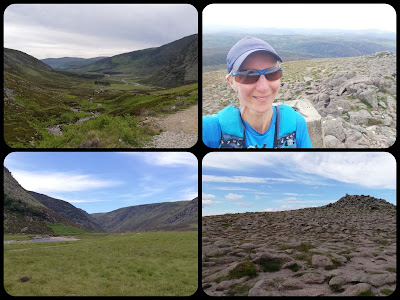
So, I jogged out to Queen's Well and marched up the hill from there (via a chat with another Challenger), very much appreciated the stunning surroundings, the good weather and the views those two elements were affording me. 

After a few minutes at the top, enjoying the views, the warmth and the lack of wind, but not enjoying the flies, I turned around and jogged back down (via a chat with another Challenger).

I've commented a few times about how often Munros, with their baggers' paths, are easier propositions than much smaller pathless hills. I reckon you'd go a long way to find a hill easier to bag than Mount Keen from the south, with an engineered path, with few steep sections, leading the whole way to the top. 

(2h31)

Saturday 19 June 2021

Four Tops from Drumochter Pass

Thursday 17 June

The Sow of Atholl (803m), Sgairneach Mhor (991m), Beinn Udlamain (1011m) and A'Mharconaich (975m) (1 Corbett, 3 Munros, with the Corbett (by definition) and two of the Munros also being Marilyns)

Distance: 20.1km; Ascent: 1100m; Weather: Overcast but dry and not too breezy

What a fabulous outing!

Probably as a result of Sunday's hill (the one where I said "Come with me; it'll be lovely!" and it turned out to be a horrible trudge on awful terrain in the rain and inside a cloud), Mick was a bit dubious when I described this circuit to him last night and suggested we go and do it today. After a bit of late night research into where we were going to park Bertie, and a run through of the key stats of distance and ascent, he agreed to come along. It was the right decision.

Layby 79 on the northbound A9 is the nearest to the start/end point, but we opted for a slightly longer walk to use the next layby along, which is set back from the road. From there the plan had been to follow the cycle path for 4km or so, down to Dalnaspidal Lodge and approach our first hill (The Sow of Atholl) via the baggers' path on its more gentle south side. As Mick drove up the A9, I looked at the map and was wavering on that plan. It only took a glance at the north side of the hill to convince me that my newly formed plan was the one to follow: we were going to head up the steeper north side, as surely the effort of the steep, pathless climb would be less than the extra distance to get around to the other side.

Fortune was on our side today. As we walked along the track that runs through the glen, we could see firstly that there was a bridge over the river, but also there was a surfaced track leading part way to our hill, followed by the line of an ATV track. The final reaches before the ATV track terminated looked, from a distance, like some sort of experiment as to how steep one can take an ATV.

The ATV track gave us easier going than would otherwise have been the case, as it led past a series of well-crafted shooting butts.

Fifty vertical metres of the ascent beyond the end of the track was so steep that the map makers had only managed to fit two intermediate lines between the 50m contours, and the rest was hardly a stroll in the park either, but once we'd heaved ourselves up to the top of this Corbett we knew that the hardest work of our day was done. The subsequent round of three Munros wouldn't involve any climb so big, nor so steep, and we were sure they would all involve trodden lines too (which they did). 


On Sow of Atholl summit looking
 at the rest of our route

Elevenses was had in the lee of a wooden-fence-panel style shooting butt just before we started the real ascent of Sgairneach Mhor. From there (and for the day in general) the views to the naked eye were pretty good (not great air clarity, but lots of lumps and bumps were to be seen stretching off into the distance). Unfortunately the photos don't do those views justice.

Elevenses view

Not much snow lingering around here

Another ATV track then took us the whole way up that next hill, where we found a Munro-bagger from Edinburgh called Ross sitting in the lee of the shelter. We joined him for our first lunch, before continuing on to Beinn Udlamain. The descent between these two hills was a springy, grassy joy to walk and the reascent on the other side was easy going too, with just a couple of hundred metres (on a trodden line) to be gained.

Second lunch was had in the shelter on that summit, during which we had a brief chat with two women who were in another section of the shelter, and also with Ross who joined us for his own second lunch just a few minutes later.

We could justifiably have omitted A'Mharconaich from our day, as I'm not specifically collecting Munros, and with just 120m of prominence, this top isn't a Marilyn. However, the fact of the lack of prominence, combined with the gentle gradient, meant it would have been silly not to nip up it, even though doing so then required a small backtrack to find a reasonable (i.e. not dangerously steep & not covered in scree) descent route. 


Conservation work (presumably) atop A'Mharconaich

The downward line we chose worked well and regaining the track in the glen it was just a few easy kilometres back to Bertie.

The temperature on the tops had been cool (the forecast said 6 degrees), but the winds had been light and the forecast showers amounted to about 3 minutes of light rain soon after setting out. Admittedly, the views would have been better under glorious blue skies, but we were happy to have had a high cloud base and benign conditions. Even better, we both managed the entire outing without once sinking a foot into a bog. A triumph!

Tuesday 15 June 2021

A Two Corbett Day

Tuesday 15 June

Corserine (NX487870; 814m)
Start: The Burnhead Car Park, by Forrest Lodge, to the east of the hill.
Distance: 13.1km
Ascent: 700m
Weather: Overcast and cool, but dry.

Parking up adjacent to these signs in the car park at just 0645 this morning...


An unlawful prohibition of camping that ought to be challenged by the local access officer.

...I hoped that our presence there at such an early hour wouldn't be taken as an indication that we'd spent the night.

A leisurely breakfast and we set off towards our hill, with every expectation that it was going to be a relatively straightforward outing. I was talking to my sister last night and explained, to her surprise, that (in my opinion) the big hills are generally easier than the obscure little ones. This was a Corbett and thus I expected it to have a trodden line the whole way to the summit, meaning that although it involved around 700m of ascent, those metres were going to be relatively easily achieved.

So it proved to be. The first 4km or so were on forest tracks and, once we'd cleared the trees, an obvious trodden line took us through a fine open landscape onto the broad rounded ridge.


Mick on the lower reaches, then approaching the cairn where we gained the ridge

Rather a lack of air clarity looking behind us

The summit was still a linear 800m away from us but it was gloriously easy walking across cropped grass, with fine views over surrounding lumps.


Summit snaps. Last weekend's hills in the background.

The wind was biting on the top and had we lingered any longer I would have had to don another layer. I'd already put on my gloves, and a buff over my ears (although that was mainly to keep my hat in place) on the way up.

Our Corbett guide book suggested a circular walk, taking in more of the ridge, and perhaps we should have done that, but we were lazy and took the easy option of retracing our steps.

Jogging the tracks back through the forest, we were back at Bertie just over 2.5hrs after setting out. A fine outing.

Cairnsmore of Carsphairn (NX594979; 797m)
Start: Opposite track entrance at Green Well of Scotland.
Distance: 11.8km
Ascent: 640m
Weather: Overcast and increasingly windy with a few short and light showers.


When I announced my intention to also visit this hill today I had it in my mind that it was a much smaller one. It was only after Corserine this morning that I looked at the map in more detail and saw it was also a Corbett. It looked to be another straightforward one, so I didn't let its height put me off and after lunch we pootled the few miles up the road to access it.

I'm sure Mick had his fingers metaphorically crossed that there wasn't any Bertie-suitable parking nearby (I'd seen a statement that the parking was good, but hadn't been able to verify via StreetView), as that would have excused him from coming with me. As it was, we arrived to find a dead-end section of old road, from before improvements re-routed the carriageway a few metres away, where you could fit a dozen Berties.

Like this morning, a track was to take us the first 4km, but this time it was open, rather than through forest. Having kept me company as far as the end of the track (which has been recently 'upgraded' in a rather rough-underfoot way; I suspect for windfarm activities) Mick turned back (as planned; he had no interest in coming to the top of this hill) and I continued on the trodden line that runs adjacent to a wall that takes a slightly indirect route to the top.


The going was generally firm on cropped grass, with just a few squidgily boggy areas, so it didn't take too much effort to haul myself up the final 400m of ascent to the trig point and cairn at the top. From there I had views over the active windfarm construction to the east and more pleasing views in other directions.


The wind had been cold on this morning's hill. It was now cold and strong enough to blow me about. I sat a few minutes in the summit shelter, inhaled a chocolate bar, and made my descent.

By the time I got back to the track the gusts were almost stopping me in my tracks as I jogged my way back down to Bertie.

(2hr20)