The Road goes ever on and on; Down from the door where it began;
Now far ahead the Road has gone; And I must follow, if I can;
Pursuing it with eager feet; Until it joins some larger way;
Where many paths and errands met; And whither then? I cannot say.

[JRR Tolkien, Lord of the Rings]

Thursday 31 May 2012

PCT: 1 day to go

Here's a tip: when, in a state of sleep deprivation, you discover that you've ballsed up the quantities on numerous items of your resupply groceries, the correct action is to drop everything and go to bed. Don't pass go, and certainly don't plough on before then spending half an hour on the phone to your mobile phone provider. By going to bed, you may just wake up refreshed a few hours later and discover that you'd not ballsed up the grocery quantities at all. You'd just completely lost the ability to count (or think, or remember your own name). Much frustration and stress could have been saved if I'd gone to bed when I found the first quantity discrepancy last night. This morning I discovered that rather than being short of rice, pasta and smash, we had a surplus. Sums never have been my strong point!

It made this morning less hectic, mind, as a bit of rejigging avoided another supermarket trip. Instead, between 4am and 9.30am, pausing only for breakfast, all of the parcels got sorted, packed and labelled.

A trip to the PO got everything mailed (two of those parcels are MASSIVE!) and now we're on our way to Agua Dulce, where we will join the trail.

Before we start hiking (ooh, I'm coming over all American with my lingo!), I do hope that a significant amount of sleep can be had.

(Incidentally, other top tips with the benefit of hindsight: 1) I should have told the credit card company that I was travelling and going to spend a lot in rapid succession in a single day on arrival. That would have maybe prevented the fraud team from putting a stop on my card causing a need to spend half an hour on the phone back to the UK to sort it out; 2) hiring a car would have allowed the resupply logistics to have been completed in half the time and would have removed the 'oh my god, we forgot X' traumas (we would have just nipped back out) - and it would barely have cost more than the buses and taxis; 3) Embassy Suites LAX North was an excellent choice of base whilst we sorted everything out. I'd definitely choose it again.)

(Louise - that was only a tiny fraction of the food; just the main meals, without the rice/pasta etc. The picture above is the rest of it. It was a lot of food!
JJ - thanks for the pointer. If we find ourselves straying into a town we'll remember that one
Alan R - no water on board yet, but I'm pleased that my backpack is feeling a manageable weight. May have to do a bit of rejigging though, as Mick seems to be carrying more weight than me at the moment.
All - thanks for your good wishes.)

Sent using BlackBerry® from Orange

PCT 1 Day to go

3.45am, wide awake, yet very tired, and wasting time trying to sort out why the Blackberry won't send email.

A very detailed phone call to the help desk last night (at an hour when I really should have been sleeping) didn't sort it out - but if this appears then I may have sorted it (last night's blog was sent via webmail, but that isn't a long term solution).

I can receive emails, so your comments are all getting through okay :-)

S'pose I may as well get up and get back to the food parcelling.

Sent using BlackBerry® from Orange

PCT: 2 Days to go

Distance: about 4 miles
Weather: wall-to-wall sunshine, but feeling cooler than the last few
days at home

What a hideous day! I always knew that today was going to be bad, and
so it was. It's a long time since I've felt this stressed.

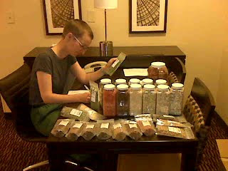
It started at 3.48am, when the jetlag determined that despite being
sleep deprived, we should be awake. At 5am I thought I may as well go
and tackle the bagging up of 50 meals, made from dehydrated
ingredients bought from Harmony House Foods. Both the ordering and the
bagging involved guesswork. The decision as to how much to buy of
which ingredients, in order to make a selection of the meals we
usually cook and dehydrate at home, had been hugely unscientific, and
the division of the ingredients, in the absence of scales or any
notion as to how much in dry weight should go in each meal, was
likewise. It's the biggest risk I can see in this trip: that the meals
turn out to be unpalatable (but hey, it's only 4 weeks of eating, and
they're nutritious even if they don't taste good!).

6am saw us having a huge 3 course buffet breakfast. The way we've been
eating lately you'd think we were in training for an Olympic eating
event.

By 10.30 the meal bagging was complete, so off to the shops we went.
It was a scenic route on the bus, apparently, and accordingly it took
a very long time to get a few miles. In fact, we could have walked it
quicker - or so I thought until we got some experience of walking in a
place that's designed for cars, not feet. At every intersection (i.e.
every few minutes) we had to wait for the 'walk' signal, which
required an entire cycle of the four way junction to pass, before
giving us about 6 seconds to cross 12 lanes of traffic. Minutes were
lost at every junction.

REI was the first stop. Aside from the gas and closed-cell foam pads
that we needed, Mick decided on the plane that his new shoes are too
small (depsite being the same size as his previous 2 pairs of the same
make and model). In REI he asked me not to disclose here that in
trying on new shoes, he discovered the reason for the tightness, so I
won't mention that he'd forgotten to remove the original footbeds
before putting his orthotics in...

The mobile phone shop, another whole lot of blocks, and whole lot of
pedestrian crossings, later, saw me spending lots of money (nearly as
much as I spend in a year on my mobile in the UK!) to get the
Blackberry working on a US network for the next month. I hope we get
some signal occasionally to make it anywhere near worthwhile, and
perhaps you could help me get my money's worth by leaving lots of
comments for me?

Then it was Home Depot for a 5 gallon bucket with lid (as requested by
one of the resupply points), before tackling the major food shop.

I knew the food shop was going to be the worst part of the day, but I
had underestimated how bad it was going to be. An unfamiliar
supermarket, with unfamiliar products and mainly significantly more
expensive than they would have been in Asda or Tesco. Then there was
the lack of choice (except for pasta, rice and noodle 'just add water
and simmer' packages - there was a whole aisle of choice there).
Chocolate was where lay the most distressing lack of range making me
wish we'd brought some from home (fear not JJ, I did significant
research on what foods we could import and we correctly declared it
all - not that customs even batted an eyelid, never mind checking that
we only had what we said).

So loaded up were we when we left the supermarket that after another
mile of walking back in the direction of the bus stop, we called a
taxi. Our shopping expedition had taken 6 hours, including the travel!

What was left of the day has been spent bagging and sorting that food,
and finding out that I got the quantities wrong on rice, pasta and
smash. Another supermarket trip will be required in the morning to
resolve that.

But first some sleep is desperately required. And some food. Somehow
in amongst all that we failed to stop for lunch.

Tuesday 29 May 2012

PCT Bound

It's been a hectic few days since we got back from Scotland. I would suggest that house buying and selling and long backpacking trips are not activities that should be combined if you want a stress-free life. Mick suggests that I may have been a bit stressed over the weekend, but then we did have a completely unexpected spanner thrown into the works.

After a smooth journey, we've made it as far as Heathrow so far, so the time for stress is over. All we have to do now is to reach our gate on time and sit on a plane for 11 hours. Then, later in the week there's a bit of a walk to do.

Checking in at the airport, you wouldn't have thought that we were off for a lightweight backpacking trip. One big holdall, one medium sized holdall, and two backpacks comprised our luggage. The ploy worked though - by putting everything in holdalls to be checked in, we can just about squeeze the near-empty Osprey Exoses (which are a bit longer than the allowed max length) diagonally into the 'allowed cabin bagage size' measurer. I didn't want the Exoses to go in the hold. That frame doesn't look like it's up to rough handling or having suitcases thrown on top of it.

Whilst the holdalls looked huge, not quite everything needs to be squeezed into our packs. There are a few re-supply items in there. The bulkiest is the seven packets of oatcakes. The rest of the food for the trip has been or will be sourced in the states (we've a big package of dehydrated ingredients from Harmony House Foods waiting for us in LA, which will be used to bag up 50 meals), but I couldn't find that oatcakes are available in the US, and couldn't contemplate a backpacking trip without them! (Hmm, we've just realised that our remaining sandwiches for lunch are still in the bag that's been checked in too - oops!)

Even with all of the resupply stuff out of the way, our packs are still heavier than I would have liked. Six and three quarter kilos in my case, which doesn't sound bad until you consider the addition of part of the tent (we've got a new TarpTent waiting in LA for us), food for 6 days, and enough water to get us to the next water-source, all of which will add up to more weight than I've carried before. I'll just have to concentrate on the fact that it will get lighter as we walk (at least until we resupply!).

More to follow, assuming that I manage to get my Blackberry active on a US SIM...


Sent using BlackBerry® from Orange

Thursday 24 May 2012

Challenge 2012 Weather

So many people who we met complained of horrendous weather. The number of drop-outs was the highest ever seen (53 out of just over 300). Yet our experience was different.

Was it purely a matter of perception? We didn't think so - the complaints of heavy rain and strong headwinds were too consistent, including amongst seasoned Challengers.

Could it really be that we had exhausted our bad luck with the weather on the Wales trip? We did wonder if it was just a comparative thing; whether the weather just didn't seem that bad to us because we were comparing it to what we had for the two weeks we were in Wales.

But, except for the temperature comparison (Scotland felt warm compared to the weather we'd had in Wales), on more detailed thought we had to conclude that we had enjoyed far better weather than most people we talked to. How can that be when we were so close to each other?

I think much of it was to do with altitude and timing.

On Day 1 we did wear our rain pants (sorry, but I'm going to come over all American and call them rain pants in this post because it's a lot easier than repeatedly typing "waterproof overtrousers" on a small keyboard!), but only because it was raining when we left Shiel Bridge. By 500m we were being snowed on and thus were no longer getting wet. As for temperature (and bear in mind that I really feel the cold) even being up high for a good chunk of the day, I was wearing just a baselayer and my lightweight Paramo.

Most people had good weather on day 2, as did we, although there was a shower which had us reach for our rain pants. They didn't stay on long. Perhaps it was the effort of the climb, but until just before the summit of Mam Sodhail I was wearing just a baselayer and thin windshirt. I did then add my shell, until we got back down to the Glen.
Everyone had a wet Day 3, and our rainpants stayed on the whole time we were walking - but whereas those further south of us apparently had heavy rain all day, for us the morning rain was light. It definitely would have been miserable if we'd been walking in the afternoon (as well as the rain, the wind absolutely howled between about 2pm until 7pm, when it suddenly died completely), so I'm glad we weren't!

Day 4 was one of those faffy days when the showers are heavy enough to need rain pants and jacket, but the dry spells warm enough to need to take them off - but as there were only a couple of showers (plus one that we sat out in a conveniently located shelter in the forest), it could have been a whole lot more faffy!

Incredibly, on Days 5, 6 and 7 we only had our rain pants on twice - once for 20 minutes on the approach to the Red Shed and for the final 2 hours on Day 7. At all other times the showers were of the type of snow that doesn't get you wet (the pre-Red Shed shower was heavy, wet snow). Thanks to the lack of wind, I didn't need my fleece on even at the top of the Lairig Ghru.

Day 8 - it rained. The rain pants stayed on all day, which for us was under 2 hours. The weather deteriorated as the day went on, and we sat by the fire watching it do so!

Day 9 - didn't get rained on once!

And then the final four days were hot and dry without any hint of a threatening cloud.

So, it is neither poetic licence nor exaggeration to say that we didn't have bad weather on the Challenge this year, but equally easy to understand that others walking lower down were being rained on when we were dry in the snow, or that those walking in the afternoons when we were sitting around drinking tea got rain that we missed.

I'd happily take the same weather experience again next year!

Sent using BlackBerry® from Orange

TGOC - Review

As I already mentioned, we thoroughly enjoyed this year's Challenge (so much so that I didn't have a single grump!). Absolutely no dispute that it was our best yet. Incredibly, despite other people's experiences, it was also the best weather of our three crossings.

Here's a review of the bits that stood out and how it went on a day-by-day basis:

Day 1
As we hauled our heavy packs and not-quite-as-fit-as-we-would-like bodies up into the snow and cloud on Ben Fhada, I doubted both our sanity and whether our navigation skills were up to the job. Sitting on the summit in a lull in the wind with big fat flakes of snow gently falling down almost made it worthwhile, but the icing on the cake was when the cloud lifted as we got towards the end of the ridge. Stunning views almost made me forget the effort of getting up there.

Day 2
With the distraction of good visibility, the climb up to Mam Sodhail didn't seem as hard as the previous day's effort - and we got to play with our spikes in nice firm snow. As much as it was a shame to be under a kilometre from the next summit, with only 100m of descent and re-ascent between them, and not be able to get there in the windy conditions, I was happy to have made the effort to get up high, however briefly. The closing in of the weather, with passing snow showers, didn't last more than an hour, so if we'd been an hour earlier or later we likely would have made it to the second top - but we weren't, so we didn't. Even so, getting to the top of Mam Sodhail was one of the highlights of the trip. Surely our fitness was improving too?

Day 3
True to forecast it dawned wet, but it was light rain and the wind wasn't bad. Having re-routed and walked further on Day 2, in preparation for the horrible forecast for Day 3, we only had 10 miles to walk. Even with a long sojourn in the Tomich Hotel, we were at our planned night-stop by 1pm, which happened to be when the weather started getting really bad. That we found ourselves a bothy, so close to our intended camping spot, and that it was so well stocked (I'll never get over the coincidence of finding the vacuum packed single serving of pasta there, when it was the very item I'd accidentally forgotten to put in my foodbag) was incredible luck. The rain had still been light, albeit the wind was getting strong, as we found the building, but ten minutes later when Mick went to the river to get water, he came back soaking. That heavy rain continued without cease for hours, until the river became a raging torrent which burst its banks. We simply couldn't believe how jammy we had been to find such good shelter just in the nick of time, and exactly where we were meant to be ending the day too!

Day 4
It wasn't about the walking on Day 4, as we didn't take our planned route, but succumbed to our FWA. The walk was okay, but the two things which made the day so good were meeting people on our way to, and in, Drumnadrochit, and then spending the night at Ault na Goire. Splendid hospitality, and the first time that we caught up with Louise (gemini-challenge.blogspot.com), Andy Howell (andyhowell.info/trek-blog), and JJ (JJ why don't you have a blog?!), as well as meeting lots of new people.

Day 5 & 6
I love the Monadhliath! If I had to choose between this year's route and last then I think that last year's pipped this year's - but I would be picking between two very nice things! Even with the regular snow showers passing through there was enough sun for Mick to badly burn his lips (he is such a delicate little flower when it comes to sunshine, though; it doesn't take much for him to need the factor 50). After enjoying the delights of the Monadhliath, we joined in a mass tea-break at the Red Shed before we made the final approach to Aviemore where we got clean for the first time in 6 days (ooh, the hat hair was outrageous!)

Day 7
I was absolutely wrong to think that we shouldn't go through the Lairig Ghru two years in a row, as in the snow it was a completely different place. There wasn't a boulder field to be seen, although with the snow being soft we were certainly aware, at times, of crossing them (particularly when I lost my left foot between two boulders, pitched forward and had my pack go over my head; visions of a broken leg flashed before my eyes, but I got away with just a painful bruise on my shin). I'm so pleased that Roger Smith encouraged us to go that way when we phoned in to Challenge Control - another very memorable highlight of the trip.

Day 8
Hardly any walking, but what better way to spend a day off than in front of the fire at Mar Lodge, catching up with everyone who passed through? Stories were exchanged, tea was drunk and a good time was had. Top marks to Jane the Housekeeper for her hospitality.

Day 9
A surprisingly pleasant walk through the woods into Braemar, in the company of Colin, followed by another sociable afternoon. With 9 miles walked in 2 days, we were raring to go again!

Day 10
The only slightly disappointing day of the trip, as I'd expected our surroundings to be a bit more interesting than they were. But, I loved having second breakfast on the Queen's lawn and having the place briefly to ourselves, before the coach parties arrived, and there were a few miles of interesting walking (plus we had our first ice-cream of the trip and saw fighting snakes!). I'm glad we went that way, because the highlights did make it worthwhile to do it once, but for the future there are better ways out of Braemar.

Day 11
Once the first 7 miles (on the old railway line) were out of the way this was an excellent day's walk with such good views that before the day was out I had a plan forming for our next walk in this direction. I just hadn't pictured an area so close to the east coast being so heathery, lumpy and remote-feeling. Admittedly the heather bashing was hard work in places (particularly the uphill heather bashing, with over 21 miles already walked, whilst carrying 3.5 litres of water apiece so we could camp on the ridge!), but as 23.5 mile lumpy days go, the legs didn't complain (at the time!).

Day 12
Ooh, the legs were tired! But I was delighted both with Clachnaben and with the descent from it and what stunning conditions we enjoyed on its summit so early in the day. We had thought that the trip would be all downhill (metaphorically) from there, but even the forest walking was good, and we saw a wildcat!

Day 13
Having camped right on the summit of our final hill of the trip (little hill though it was), with a view of the sea, was strangely pleasing. And, it was so hot that we hadn't put the fly-sheet on the tent until bedtime (needn't really have bothered even then, but better safe than sorry). Someone had obviously turned off the 'winter' switch, skipped 'spring' and flicked the 'summer' switch instead! A pleasant breeze cooled us on our final walk in and we reached Stonehaven beach smiling like loons after a stunning trip. As something of a departure from the rest of the trip and our previous finishes, we didn't see another Challenger from 8.30 on Monday morning until we reached Challenge Control on Wednesday lunchtime.

Overall
Definitely a trip to remember!
Sent using BlackBerry® from Orange

Wednesday 23 May 2012

TGOC Day 13 - Leachie Hill to Stonehaven

Wednesday 23 May (0730-1045)
Distance: 9.5 miles
Weather: wall to wall sunshine (and hot enough to be wandering around in a t-shirt and pants at 6am!)

It was a very warm night again with a bit of a disturbance at 2am. I woke to hear what I first thought was a deer grazing just to the side of the tent. Sitting up to peer outside disturbed Mick and he could clearly hear it too.

We thought that unzipping the mesh to stick a head out would scare it away, yet the noise continued and there was no deer to be seen - or any other animal for that matter.

We lay back down, but on went the noise and I became convinced that it must be a rodent chewing at my bag. Door unzipped again, my bag was inspected, with no hint of any chewing. But on went the noise.

We did eventually find the source and you really wouldn't have thought that a family of big black beetles (Beetles Of Unusual Size, I'd say) could make so much noise!

With a few more hours of kip had, up we sprang for our final walk in to Stonehaven. It wasn't just a matter of dropping down the hill to the road, as I had opted to take us along the edge of the forest for a while first to avoid too much tarmac.

A bit of a heather bash saw us onto easier terrain and even with a couple of tricky fence crossings it was a pleasant walk, keeping us up high enough to enjoy the hazy views.

Finally we did have to drop down to the road for the final walk in.

I can't say that we saw an awful lot of Stonehaven, although we liked what we did see. Having made a bee-line for the sea and taken the obligatory finish photos (pity we forgot to take any start photos!), we thought we'd find out the bus times to Montrose, and having arrived at the bus stop at the same time as the fast bus to Montrose, on we got.

So, a third TGOC complete and we've had such a good time. I might just write a separate post about our reflections on the trip.

Sent using BlackBerry® from Orange

On Stonehaven Beach...

... Where we arrived at 10.45 after an excellent couple of weeks. More to follow...

Sent using BlackBerry® from Orange

Tuesday 22 May 2012

TGOC Day 12 - Hill of Badymicks to Leachie Hill

Tuesday 22 May (0750-1510)
Distance: 14.5 miles
Weather: hot and sunny
Number of wildcats seen: 1
Number of deer population analysts encountered: 2

Let's start with the highlight of the day: Clachnaben. What a fantastic little hill! In a sea of rolling, heather- and peat-clad hills, it stands out due to an unmissable big rocky outcrop that sits on its summit. Thanks to that outcrop, we had the hill within our sight for much of yesterday afternoon, and three minutes before we camped today it was still visible through a break in the trees.

At just gone 9am, we clambered up to the top of that rocky knoll (which looks like it belongs in the Peak District) and took in the views. Hazy, but extensive.

Our delight wasn't over as we descended under stunning blue skies, as after the steep stone staircase of a path we found ourselves next to a gorgeous burn, complete with some fine pitches. We will keep them in mind for future walks!

Opting to ignore a 'private access only' sign, a track too us down to a B road, which we followed for 1km, before heading off into the forest. Nine miles we've just walked through the forest and that could have been a bit of a dull, cold green-tunnel of a walk. As it went we walked seven and a half miles before we got hemmed in by trees, and then it was only for a few minutes, so we were in the sun and enjoying views almost all of the time. The combination of sun and views led to some unusually long breaks being taken!

Leachie Hill was where we'd had in mind to camp so it was with pleasure, on our approach, that we saw that it sported as many grassy areas as heather. The grass is tussocky, but some hunting around, just beyond the trig-point, found us a flat-enough pitch and so we've the rest of the afternoon off. It's also quite pleasing to be pitched within sight of the sea.

As for the weather - well, we seem to have gone from deep mid-winter to mid-summer in the blink of an eye. Even though we camped at 1800' last night (a height at which we were walking through snow on Day 1), and even though there was a clear sky, it was a warm night. It's been another warm day too, which does make a nice change - even if it does make the bag a bit heavy, what with carrying all of those clothes that I was wearing for the first week or so!

(Alan - I'm not using my lovely PHD bag on this trip. I decided that, being in need of a clean, it couldn't cope with both this trip and the US trip, so I'm saving it. Instead I've got my Rab Quantum 400W, which is far warmer than I remember it being (mind, it is also far heavier). I've not had to use the hood once on this trip.
Conrad - I was also advised that it's 'clack na ben', with a short 'na' and emphasis on the 'ben'. I'm so pleased that you pointed it out to us; having been there I would hate to have missed it.)

Sent using BlackBerry® from Orange

TGOC Day 11 - Ballater to Hill of Badymicks

Monday 21 May (0745-1800)
Distance: 23.5 miles
Ascent: 4000'
Weather: warm and sunny again!
Number of adders found basking in our path: 2
Number of mountain hares: 8
Number of mice which ran around us whilst we ate tea: 1
Number of emergency mustache-trimming stops: 1

That was a long day, and latterly quite hard going too.

It started fast and easy, but lacking in significant interest, as we took the Deeside Way from Ballater to Dinnet. Being a disused railway line it was flat and at times so straight that it felt like we were on a treadmill. The treadmill-effect was countered by making a few phone calls as we went, calling in to Challenge Control and indulging in a little kit shopping.

Within 2 hours of leaving we had covered the first 7 miles (a third of our intended day), but we knew that we were soon to slow down. Having stopped for elevenses on a bench outside of a fishing hut on the river, we took to some tracks which were to take us into Glen Tanar.

It was along one of those tracks, with sweet-smelling gorse in bloom, that the emergency mustache trimming was required. An errant looped-back hair on Mick's now-bouffant mustache was tickling his nostril, but the trusty Swiss Army Knife (which must be one of most used items) sorted things out.

The walking was now pleasant, with some points of interest and some good views, including the white tops of the Cairngorms poking out from behind the nearer, more modest, hills.

Challengers Jan and Chris appeared as we were admiring one view and we walked with them for a short while until Jan decided that a change into shorts was required. It really was that warm today - or at least it was when walking. We did get a bit cool when we stopped in the shade of a tree for lunch.

Only a few hundred yards after lunch the track was left for a yomp over to Hill of Duchery. It turned out to be something of a heather bash, but it wasn't for dreadfully far before we picked up another track.

We had been uncharacteristically indecisive, on the approach, as to which way to go when we got to Birse Castle, but in the event the decision was made for us. A Scottish Rights of Way Society sign asked us not to go straight on, through the grounds of the castle, but to follow the marked path around it. That was one of the options we had contemplated, so we were happy to comply.

We had saved the biggest climb of the day until last (or at least, it should have been last), but it wasn't as bad as it looked from a distance. At the top of that climb was the first of the two Cock Hills (obviously a bit unimaginative around these parts, as they're only just over a mile apart), from where another yomp was on the cards, over towards the other Cock Hill.

Our intention wasn't to go all the way there today, as in between them lies the Water of Aven, which was to be our night-stop.

We got there at 1620 and spent not less than 40 minutes considering potential pitches. Nothing good was springing out at us, even with a substantial survey of the area. Big tussocks and heather ruled.

Eventually, having found a spot which was flat and dry enough, but then having discounted it for failing the tick-test, we decided that we would continue on for a couple of miles (including a big uphill heather bash, complete with peat hags), hoping that a building shown on the map would be an open shooting hut.

And so it might have been, if we hadn't walked straight past it, distracted by another hut which was in plain view, further along on the other side of the track. Alas, when we got there it was a very smart (and very new) double-glazed wood cabin (a summer holiday villa sort of a place), which was firmly locked up. We did give thought to pitching on its deck, in the absence of any other campable land, but opted to continue to the second hut we could see.

That one was open, but was an uninvitingly damp, dirt-floored place. We used one of the table and chair sets inside to cook and eat tea (the sofas were too damp and mouldy!), but opted to camp elsewhere. The problem was that we still hadn't seen any obvious pitches. There were some good flat areas nearby, but all covered by the remains of old heather which would threaten the groundsheet of the tent. What we needed was the extra protection of a second groundsheet, and what do you know, but inside the hut was exactly that - and almost the exact size of our tent footprint.

Having borrowed the footprint, the tent was soon up and finally the weary feet and legs are being properly rested. With just 27 miles to go to the coast, by my reckoning, and with 2 days at our disposal, tomorrow should be a bit easier and shorter than today.

(Conrad - we've had Clachnaben within our sights for much of the afternoon and look forward to getting there in the morning. It looks an interesting hill, so thank you for the recommendation)

Sent using BlackBerry® from Orange

Sunday 20 May 2012

TGOC Day 10 - Braemar to Ballater

Sunday 19 May (0730-1430)
Distance: 17.75 miles
Weather: Sunny! Warm!
Number of fighting snakes nearly stepped on: 2

When we left the tent without our headtorches yesterday afternoon, we expected to be back before dark (it not being dark up here until gone 11pm). What I didn't expect was for the football to go to extra time and then penalties. It was later than we expected when we found the tent and crawled into bed.

We were still up bright and early this morning, and a bright morning it was too. Finally, some sunny weather, although it was a bit parky first thing.

Whilst the weather was very pleasing, the day's walk was a bit disappointing. It did have its highlights, but after 9 days featuring a grand total of fewer than 15 miles on roads, today featured more road than I would have liked.

We did keep off the roads as far as possible, with the map suggesting that only just over 4 of today's nearly-18 miles would be on tarmac. The reality, however, was a little more, as what looked like tracks on the map, around Balmoral, were surfaced.

Balmoral Castle was one of the highlights of the day. I'd not seen it before, and as we stopped on a bench for second breakfast (from where the photo above was taken), we had the place to ourselves. Minutes later the contents of a couple of coaches appeared around the corner. Our timing had been excellent.

The next highlight, after a couple or miles or so along a B-road, was an old track which goes around the back of Creag Ghiubhais. It was a bit longer than continuing along the road which runs the other side of the hill, but it got us off road. The track was rather overgrown, but it was easy enough to follow if you don't mind wading through heather, and under the blue skies the surroundings were quite lovely.
Mick was a little unconvinced about the next off-road detour I had planned, as it was noticeably longer than just following the road. He came around to my way of thinking, and it was definitely the nicer way to go, first crossing over a foot-bridge (which looked new from a distance, but has actually stood there since 1892), and then following a waymarked path which, after a while, took us to the river. It was along there (right on the path) that we encountered what I first thought was a single, very long snake, but was actually one snake biting the tail of another. They wriggled around until the one in front also had its fangs in the tail of the one behind, such that a full circle was formed. More wriggling and biting and a game of chase ensued until the one in front managed to get away. With both having hidden in the grass, on we went.

Arriving at a sunny bench on the outskirts of Ballater at 1345 we thought we'd best slow down a bit, so plonked ourselves down for some lunch (herring fillets in mango and peppercorn sauce - tasty!). Being so nice in the sun (with a river and snowy mountain view) we could have sat there for an age, but equally, if we stirred ourselves to walk another mile or so then we could sit in the sun for the rest of the afternoon.

And that's what we did, just pausing for an ice-cream on the way. It seemed wrong to shun an ice-cream in the first good weather we've seen!

Since we arrived at the campsite a good handful of other Challengers have come in, so we've been occupied by watching various makes and models of tent/tarp go up and catching up with people we've not seen for a while. Everyone seems to be in agreement on one thing: it's nice to have some fine weather. I don't think there will be any complaints (other than cold nights) if it continues.

(Conrad - did the shorts get up and walk by themselves when you took them off? That makes my 12 days look quite reasonable! (And I'm not admitting to how long I wore a single pair of socks continuously...). Unrelated to that - loved your knee via ferrata photo!)


Sent using BlackBerry® from Orange

Saturday 19 May 2012

TGOC Day 9 - Mar Lodge to Braemar

Saturday 19 May (0900-1045)
Distance: 5 miles
Weather: overcast but dry, high cloudbase

Another very short day led to a late start - that and the fact that I didn't wake up until 7.30. It must have been a comfortable pitch!

We'd walked all of a quarter of a mile this morning before the first faff of the day was required. We'd just hit the road at Victoria Bridge when I realised that the map in the mapcase ended at Mar Lodge and the one we needed was tucked away inside of my pack. If our plan was to walk the road to Braemar that wouldn't have been a problem, but I didn't even know where we were to turn into the forest for our off-road route.

Colin joined us as we faffed and as a trio we ambled to Braemar. A pleasant walk it was too. I'd had in mind that it was going to be a made track through a bit of commercial forestry, so it was pleasant to find an old track, which became a muddy path in places, and wandered through a clearing and on through native woodland.

The walk flew by and before we knew it we were dropping down into Braemar, where Mick voted for a bacon (and sausage and egg) bap stop before we went to the campsite.

With the tent pitched there were chores to be done (my trousers didn't get a wash in Aviemore and were getting desperate!) before we hit the Fife Arms for a bit of chatting (not that there wasn't plenty of chatting done in the laundry room - it's a good place to meet lots of people!). The afternoon has involved food, drink and chat, so another good day in TGOC-land.

Tomorrow the hard work recommences as we get back to proper mileages.

(Today's photo: I popped into the Ballroom at Mar Lodge this morning after everyone was up to take a snap of the deer skulls, although the position of the roof-lights means it's an even worse effort than my usual snaps. For those who didn't see the comment, Theo advises that there are 2435 red deer skulls on display (did you double check Theo?!) Apparently some who slept in there last night (warm and comfy, as the heating was on) did wonder about the likelihood of any of the skulls dropping off their mountings during the night)

(Martin R - certainly an interesting year weatherwise (again). It's added an extra element to a good walk - but it would be nice if we could have a few sunny days for the final walk in!)


Sent using BlackBerry® from Orange

Lairig Ghru Photo

My camera was tucked away in my bag on Thursday, but Mick did snap me with his as we passed over the Lairig Ghru. If I've sussed out how to do this on the iPhone, then the photo should be above.

TGOC Day 8 - Derry Lodge to Mar Lodge

Friday 18 May (0940-1100)
Distance: 4.25 miles
Weather: early light snow had turned to light rain by the time we set out

Even though we spent so little time walking yesterday, I somehow didn't find the time to write a blog post at any time during the afternoon. But, it probably goes without saying that, with only just over 4 miles walked, yesterday wasn't about the walking.

Having arrived at Mar Lodge we installed ourselves in front of the fire where we stayed for the next ten hours, leaving only to put up the tent during a late-afternoon break between showers, and to have our evening meal, which was served in the kitchen.

There were only 8 of us booked in to camp and for the meal, which soon swelled to ten as two more early arrivals snapped up the last two remaining spaces at the table. It was to be a small affair compared to the normal Friday night at Mar Lodge as, with no inside accommodation being available this year, most people opted to push straight on to Braemar.

Many stopped by for a cup of tea and to dry out a while by the fire, so much chatting was done as the day went on. I appointed myself fire-monitor, and as the Housekeeper (Jane) became run off her feet when the hoards started arriving, Mick made himself useful as tea-monitor.

Amongst the many topics of conversation, the weather cropped up a lot. From all reports it seems that, once again, we have been incredibly lucky. Almost all reports suggest that we've experienced far better weather than most. Strong head-winds and continuous heavy rain have been the norm for many as they've battled on through. Fingers crossed that our localised luck continues.

After a very sociable day and evening, everyone gradually drifted away to their sleeping quarters as the 10pm curfew approached. Twelve tents were pitched behind the ballroom, and more opted to sleep inside the ballroom - their slumber being watched by the hundreds (a thousand, even?) of deer skulls that adorn the walls and roof timbers.

Now it's time for me to get out of my sleeping bag, and prepare for today's monster walk of (wait for it...) five miles into Braemar.

Sent using BlackBerry® from Orange

Friday 18 May 2012

TGOC Day 7 - Aviemore to Derry Lodge

Thursday 17 May (0920-1740)
Distance: 18.5 miles
Weather: continuous light rain/snow (depending on altitude)
Number of train (and station) wrecks witnessed: 1

We spent last evening doing little except for eating, eating and eating some more. Yet I still woke this morning ready for a full cooked breakfast. Can be hungry work, this walking!

Even though our breakfast was reasonably early, by B&B standards, we were late away, and then made later by much faffing. First off a detour to the chemist was in order for ointment to sooth Mick's swollen, blistered lips, then a few paces down the road he realised that he'd accidentally packed his hat right at the bottom of his bag.

Onto the railway station platform we went for some shelter whilst he unpacked, where, over on the Steam Train platform men were in the process of using a small 'tug' sort of an engine to move another engine. Then there arose such a commotion! It turned out that the 'tug' and the first sets of wheels of the towed engine had successfully moved track at a set of points. The rear wheels had continued along the original track. The result was a bogie was partially ripped from under the engine and the engine swung at such an angle as to do some significant damage to the platform - all of which, as you might imagine, occurred with quite a lot of noise. The engine came to rest with its rear buffer wedged on the damaged platform, with men in orange jackets scratching their heads as to what to do (I imagine the answer was to order a large crane and some station-platform repair people).

All that excitement, and we hadn't even progressed 100 yards from our night stop!

As it transpired, being so late setting out was beneficial.

We had discussed the best option for today often over the last six days. Our route sheet stated three possibilities: for good weather we would go over Ben MacDui and Derry Cairngorm; in mildly foul weather we would go through the Lairig Ghru; and in really foul weather we would detour down to Glen Feshie.

After what we found on the hills in the west, and knowing that there was even more snow in the Cairngorms, it seemed unlikely that we would do the high route and we debated at length the other two options.

After the snow of the last couple of days, we were even wavering as to going through the Lairig Ghru - plus it seemed like a rather weak option in that we did it last year.

Then yestersday I came up with another alternative: to go via Glenmore and Fords of Avon. It was our favoured plan until we called Challenge Control and were told that people had been passing over the Lairig Ghru without issue, but that the Fords of Avon were proving difficult to cross with the current water levels.

Lairig Ghru it was then (even after the extra snow that fell last night), and it wasn't an exact repetition, as this time we paid attention and didn't accidentally take a big detour via Rothiemurcus Lodge, plus last year we didn't do the route in the snow.

And it was the snow that made me glad that we were late out of Aviemore. It would have been hard work had we been first over there today, but as it was others had broken trail before us, so we just followed in their boot prints (even when we wondered at the line they'd taken!).

The snow wasn't inconsiderable either. Even using other people's boot prints, and choosing the shallowest of them, I was often up to my knees, and every now and then I went in up to mid-thigh.

That said, it was an excellent and interesting walk, and even though the place looked entirely different to last year, it was still completely stunning.

Alas, the snow which had been falling gently on us turned to rain as we descended, but it was very light until about 4pm. We were just passing the path to Corrour Bothy when we had to concede that the it had become enough to need waterproof trousers.

Corrour wasn't to be our night-stop this year. I reckon it's going to be busy tonight (we've seen 7 people intending to stay there). Instead, we continued on down the path, which bore a remarkable resemblance to a stream (everywhere's either waterlogged or running with water this afternoon), to Derry Lodge.

We're camped here with another Challenger, Dave. We caught up with him on the way up the Lairig Ghru this morning, but he went on ahead when we stopped for a series of faffs, and we didn't catch back up until Luibeg (where we all detoured to the bridge as the ford didn't look advisable).

He's off to Braemar tomorrow, whereas we've got an incredibly strenous day of walking all of 4.25 riverside miles to Mar Lodge.

(John - I think we'll be getting some of that paint. Maybe if the whole peg was a startling colour, rather than just the top, then we'd notice them lying in the grass!
Alan - it was a bit cool when the sun went in and the showers passed on Tuesday, but overall the weather hasn't been too unfriendly thus far - and as long as we keep moving we've not been feeling the cold.
Geoff - I saw your report about your shoes. An outrage, if you ask me - I'd be livid to see such wear after so little use on a boot of that price. No mention of boots from me because I'm not weating any - it's carpet slippers again for me (Inov8 Terrocs) and I expect to get 500 or so miles per pair. On our LEJOG I wore Scarpa ZG65s and I've just thrown that pair away with about 1200 miles on them (which seemed pretty good for a £85 boot). I do hope Scarpa does the right and honourable thing and replaces them for you.)
Sent using BlackBerry® from Orange

Wednesday 16 May 2012

TGOC Day 6 - Coignafeuinternich Ruins to Aviemore

Wednesday 16 May (0725-1500)
Distance: 16 miles
Ascent: 1600'
Weather: sunshine and showers (all snow until Aviemore)
Number of mountain hares seen in last 24 hours: 7

Mick thought that last night was cooler than the previous nights. In my warm sleeping bag, I didn't notice, but he must have been right as our morning involved crossing iced-crusted peat hags, with icicles hanging off the overhangs. I suppose the fact that it was snowing quite convincingly when I peeked out of the front of the tent may have been a bit of a clue too (a surprise, though, as it was lovely dry snow and so made no sound on the flysheet).

Before we got to the icy peat hags, a walk was enjoyed up the Allt Mor. Although not shown on the map, there's a track which runs up to about 590m, and beyond the track the ground may be a bit boggy (as you'd expect, given the lie of the land), but it's a straightforward walk.

It's the bit between the Allt Mor and the Caochan Crom nan Eag that involves weaving through peat hags, but it wasn't a difficult passage and the icy crust assisted us.

Picking up the burn running down to the Dulnain started the section which was the highlight of our day. It's a stunning burn, which we crossed over and over again as we picked our way down its length. If you've not been there, then it's definitely a walk worth doing if you happen to find yourself in the Monadhliath (you wouldn't struggle to find a good pitch down there either).

A while before a waterfall, the valleysides become steeper and deeper, so we left the side of the burn to climb out of the dip and heather-bash over the open hillside. Traversing the side of the Dulnain valley we slowly dropped down to pick up the track which leads to the Red Shed bothy, which we had earmarked for a tea-break.

A tea party was already in full swing, with 6 other Challengers, when we entered, and we soon had the stove out to join in. We didn't stay in company for long though. Either we smell a lot (well, it had been 6 days since the last shower!), or the other chaps' tea break had reached its natural conclusion. They left us after 20 minutes or so, just as another snow shower passed through. We stayed about a quarter of an hour longer and left in the sunshine.

The Burma Road was our route into Aviemore and there's not much to say about it. It gives some good views and very quick walking, but it is something of an intrusive blot on the landscape.

It started to rain as we approached Aviemore. Ruining our 2-day run of snow and hail showers which haven't got us wet. It wasn't heavy rain though, so the waterproof trousers remained untroubled in our packs.

Having arrived in town, we're not being sociable at the campsite tonight. We had Aviemore earmarked for a bed, so we're B&Bing it. A long time has been spent in the shower and our host has kindly done our washing for us (saving me time standing at the sink!), so we'll be setting out squeaky clean in the morning, and well rested (I hope!) after a night in a proper bed.


Sent using BlackBerry® from Orange

TGOC Day 5 - Errogie to Coignafeuinternich Ruins

Tuesday 15 May (0715-1615)
Distance: 21.25 miles
Ascent: 3500'
Weather: snow/hail showers, with some sunny intervals

The field of tents was coming fully to life this morning as Mick and I finished packing and set off down the road. I'd realised last night that today's mileage as I'd written it on our itinerary was understated (even though I'd put the right number of kilometres on the official route sheet - but my mind doesn't work in km). That meant that we had over 21 miles to walk today, rather than the expected 19.5. Add in a hill to go over, and we decided that an early start was required.

Having left the road after Errogie, we made far less of a meal than previously of getting ourselves to Dunmaglass Lodge. In fact, we didn't make any meal of it at all and must have been three times faster in covering the distance than last year.

Just after Dunmaglass we left our previous route as this time we were headed on a 5.5 mile gentle ascent of Carn na Saobhaidhe. As Corbett bagging goes, this one feels like something of a cheat, what with a track leading the whole way to the summit. But, even though it felt like it was too straightforward, it was still a good place to stand on a clear day. We were up in the snow and in every direction there were more snowy tops to be seen.

The cross-country yomp down the other side, through peat hags and generally waterlogged terrain (hopping back and forth from one side of a stream to the other to pick the better ground) was friendly, as these things go, too, so it wasn't long before we were joining another track, which would lead us down to the River Findhorn.
About a mile down that track I took the photo at the top of this post, looking back up the Allt Odhar. That blue sky is deceptive. Even as I took the photo snow was starting to fall. Until that point all of the showers had been of hail (and even they were gentle hail showers - no stinging impact, just hail falling gently down on us in the absence of strong wind), but this one was snow. It was prolonged too as a mile and a half later it was still falling.

Being 2pm by this time, we were eager for lunch, and having now reached the Findhorn valley we were less than eager to start our walk along it with the snow blowing into our faces. Instead, we took shelter in the lee of a building (Dalbeg) and tucked into lunch. About half way through, the snow really started to come down - it was like a Christmas movie - but it was just the last hoorah of the shower as minutes later we were bathed in sunshine as we watched the wall of white work up the valley.

Everything I've seen of this area has been spectacular, and the Findhorn valley is no exception. We said last year that we'd like to see more of it, and today we walked about 6 miles of its length. Six miles of loveliness.

Arriving at our night stop at just 1615, we were surprised to have arrived so early (21 miles covered in 8 hours of walking, including a hill)- testament to what a comparatively straightforward day of walking it was. I certainly expected it to be much more arduous.

So, another excellent day, with the added bonus that with all of the showers being of the frozen variety today, we didn't even get wet (well, apart from the feet during the bog wading - maybe I should have put my waterproof socks on!)


Sent using BlackBerry® from Orange

Monday 14 May 2012

TGOC Day 4 - River Enrick to Errogie

Monday 14 May (0815-1700?)
Distance: 16 miles? (the route sheet said 17, but it didn't feel that long)
Weather: sunshine and showers

Apparently, it rained some more during the night. Personally, I was too busy sleeping to notice. It must have been much less rain than fell between 1300 to 1900 yesterday, because by the time I looked outside this morning the flooded roaring torrent outside had returned to its previous state of being a benign river.

Being not in a hurry this morning, much faffing and tea drinking was had before the off, and by the time we did tidy up and leave, the rain had passed and a sunny interval was upon us.

Even though the river level had dropped again, suggesting that the other water crossings on our main route would be passable, Mick wasn't fancying the higher (mainly pathless) route and a day of bogginess (I think he's scarred from the Wales walk!). So, it was a gentle stroll along tracks into Drumnadrochit - and an inoffensive stroll it was in the main, as forest walking goes. There were enough clearings to give views, although we'll gloss over the initial track which is in the process of being 'upgraded' for the installation of a windfarm, and is currently not only an ugly scar, but a horrible surface for walking.

The other benefit of the alternative route was that it was more sociable than our proper route would have been, plus we got into Drum by 1330, giving us plenty of time to eat, drink tea and chat in the cafe before heading up the road for the ferry.

Our wait for the ferry wasn't as long as we had expected when we set out this morning, as a text exchange with Gordon (the ferry man) revealed that he was planning an early, 1600, crossing of Loch Ness. We arrived at his jetty half an hour early, and as our arrival made the numbers up to twelve, there was no waiting around and we were soon underway.

A walk up the road to Errogie has seen us arrive at the croft where Challengers are not just welcomed to camp with open arms, but are given tea and (very lovely) cake on arrival. Obviously word gets around about such fantastic hospitality, as there are 17 tents here this (showery) evening.

(Today's photo is of last night's accommodation, taken in this morning's sunshine)

(Martin R - I've a feeling that yesterday's wind may have come close to living up to that forecast. Glad we weren't up high yesterday!
Geoff - certainly do!
Alan - thus far I would say that the weather has made things 'interesting' rather than marring the walk. Which isn't to say that we wouldn't much prefer wall-to-wall sunshine!
Duncan - hello stranger! <Waves>
Conrad - thanks to the 'Hill Lists' app, all hills, from every which list, are getting 'ticked'. It did cross my mind that it could be a dangerous way forward!
Gibson - pity we didn't know you were at Morvich; it would have been good to say hello on our way past.
Jamie - although the daytime temperatures have been cool for the time of year, what I've noticed so far is how warm the nights are (as you'd expect with cloud cover). Or maybe it's this heavier sleeping bag that's doing it!)


Sent using BlackBerry® from Orange

TGOC Day 3 - SE Short of Loch Beinn a'Mheadhoin to

Sunday 13 May (0745-1300)
Distance: 10 miles
Ascent: a gentle 1200' ish
Weather: continuous light rain
Number of slugs wot I accidentally cooked (but didn't eat): 1

The wind whistled overhead last night, mainly missing us in our sheltered position, but it was certainly a bit damp. No hammering rain, just a continuous gentle pitter patter.

That gentle rain continued as we made our way through the natural forest that makes up the Nature Reserve in which we had camped, and then over to Tomich.

Even when we popped out of the forest we weren't bothered by the wind. It was behind us, and not of any notable strength at our low elevation.

"Bit windy out there" said the chap in the Tomich Hotel when we nipped in for a pot of tea. We wondered whether it really was and we'd just not noticed, or whether it was just the perception from indoors.

It was only 10am when we arrived at the hotel, and we only had just over 4 miles to go, so we weren't in any rush as we supped our tea (and I may have been cheeky enough to nip off to the ladies to do some washing of smalls, but I'm not going to confess to that). An hour passed before we left.

It was still raining as we left and as we gained height, the wind did become noticeable, but it wasn't long before we were following an old boggy, grassy track through another chunk of forest, giving us shelter once again.

By the time we dropped down to the River Enrick the weather was really getting a bit wild and a decision had to be made. Per our route sheet, alongside the river was where we were to spend the night. Having walked further than planned yesterday, we had thought to extend today to cover a couple of miles of tomorrow, but now we had to wonder whether sticking with Plan A was the better option.

To assist our decision, we detoured slightly to investigate a small patch of woodland, just off our course. The map showed a building in that woodland, and of the four possibilities as to what that building could be, one was a bothy. There was no doubt that if our luck was in, and it was a bothy, then we would call it a day at just 1pm.

Our luck was in. When we finally got the front door open we found a room with a sofa, an armchair, a stack of wood, a bag of coal and some firelighters. Even more lucky (incredible coincidence you may say, if you recall that in my last post I said that I was a bag of pasta missing), the only food that has been left here is a vacuum packed single-serving packet of spaghetti!
Since we arrived the weather has become really wild out. Hope the worst blows through by morning!

(Post blog note: the fire didn't last long. Every time the wind blew, the room filled with smoke. With the wind constantly blowing, we soon smelt like kippers, and let the fire die)
(Post-post blog note: as the afternoon progressed the weather got worse and worse. The rain was horizontal and the roof was rattling away. At about 1730, we were joined by Sue and Chris, who we first met in 2009. They'd had a bit of a rough time battling the weather from Tomich. At about 1900 the wind died so suddenly it was as if someone had flicked a switch. Without the wind, the second attempt at a fire was a success. At 2015 the sun briefly came out. We rushed outside - and found that the river had burst its bank just upstream and that the track on which we had walked in was now underwater. Quite an impressive change in what had been such a gentle benign river just a few hours before.)

Sent using BlackBerry® from Orange

TGOC Day 2 - Beyond Alltbeithe Youth Hostel to SE shore of Loch Beinn a' Mheadhoin

Saturday 12 May (0750-1700)
Distance: 15 miles
Ascent: 3600'
Weather: fine morning, light showers later; windy up high
Number of German men seen wearing a bin bag in place of waterproofs: 1
Number of ticks found embedded: 1 (me)
Number of items lost: 1*
Number of items found to be missing: 1**

The fine weather route for today was to go up Mam Sodhail, over Carn Eighe and then along the ridge all the way to Toll Creagach. Even after yesterday's ridge experience, we'd thought that if the day dawned fine then we'd give it a go.

Then, just after we pitched the tent last night, I remembered our vetter's comment about some vertiginous bits on that ridge. More consideration was made of the map and we had to conclude that maybe it wasn't the place for us to be in the current snow conditions.

However, I didn't really want to stay low if the weather was nice, and our FWA would give us an awfully short day.

Plan C was hatched: we would go up Mam Sodhail and Carn Eighe as planned, then would back-track a bit and drop down to the path along the Allt Coire Leachavie. The reality only fell slightly short of the plan.

Having woken up to fine skies, we were on for tackling our hills and we were only delayed in our departure by chatting to some passing Challengers who had stayed at the YHA last night.

Once we'd reached our turn to head uphill, getting up to 900m was uneventful. The snow had receded overnight and we hadn't hit the snowline until gone 750m. However, by 900m the path was covered by deep snow and a short while later it kept disappearing under more extensive snow fields. With the snow being quite firm, when we finally lost its line we simply donned our Microspikes and headed straight up to the ridge.

A few hundred metres before we reached our first planned summit two things happened: we met a chap called Steve (who it turns out we came close to meeting on the Cape Wrath trail in 2010), and the wind picked up with some violence. As a trio, we made our way up those last few hundred metres (I brought up the rear, taking advantage of the steps kicked by the chaps!).

Our planned out and back to Carn Eighe was abandoned as we reached the summit. It was wild up there! Steve made the same decision and after a quick break in the lee of the huge cairn (taking advantage of mobile signals, Steve checked in with his wife, Mick caught up with the news headlines and I sent yesterday's blog), and with cloud having drifted in with snow not far behind, we all battled the wind to get back down.

On the one hand I was glad for Steve's bootprints showing his ascent route from the Coire, but on the other hand I'm not sure his route was wholly advisable. Particularly as we were now on the south side of the hill and there was no firmness at all to that snow. Horrible, wet, heavy, slippery snow is not good on such a steep descent. Still, we made it down with all limbs intact and enjoyed the spectacle of the tumbling stream as we made our way back down to Glen Affric.

At 2pm, we arrived on the track which runs along the glen, a whole 3 miles further along from where we'd left it over 5.5 hours earlier! Definitely worth the lofty detour, though. The tops had all been clear and the views had been tremendous.

We then had to make a decision as to where to end our day. We had thought maybe at the parking/picnic area at the E end of Loch Affric, but the car park was far too busy to be pitching at 3.30pm, so on we continued (thus foregoing the convenience of public conveniences).

At about 4pm we collected water in preparation for camping at the first pitch we found. At 4.55, I pointed out (perhaps a bit grumpily) that a lovely flat grassy area wasn't going to just present itself next to the path, but that we'd have to go looking for one (it's been a hard couple of days and I was desperate to stop). Around the next bend I was proved wrong. Having not seen a hint of a pitch for 3 miles, around that bend was a perfect flat bit of grass just off the track. Mick's mischievous suggestion that we should walk on for another mile received a suitable response and having cleared a million twigs from the area we soon had the tent up.

After a couple of day's of hard (but rewarding) work it's now a couple of shorter/low ascent days to take us into Drumnadrochit.

(*Even with a strict 'count them out, count them back in' routine, we have a history of losing tent pegs. The rate of loss slowed when I put red sleeving over their tops, but we still managed to lose another one yesterday.
**We have a very detailed checklist at home which has evolved over a number of years. Unfortunately the checklist isn't sufficiently detailed to ensure that I don't forget a serving of pasta. So, tomorrow I'll be having pasta sauce and muesli bars...)

Sent using BlackBerry® from Orange

Saturday 12 May 2012

TGOC Day 1 - Shiel Bridge to beyond Alltbeithe Youth Hostel (Glen Affric)

Friday 11 May 2012 (0815-1655)
Distance: 14.5 miles (as measured in straight lines!)
Ascent: 4200
Weather: mainly snow (rain lower down), but with some short fine spells later
Number of times I fell over: 5!!

Three hours into this morning I had to wonder why we were slogging through snow, in attrocious visibility and huffing and puffing our way from sea level to top out at just under 3400', when we could just have taken the valley path and been at Alltbeithe in time for lunch. I'm not sure what the enjoyment is of walking up hills when you can't see anything of them, but my incentive was simply to gain a bit more fitness before we hit the PCT at the end of the month.

Even though Shiel Bridge is one of the most popular signing out points (56 people this year), it had seemed fairly quiet last night and although we saw a few people milling around as we signed out, and passed a couple on our way to Morvich, we didn't then see any other Challengers until Alltbeithe, some 14 miles later.

We did see one day-walker. He'd been ahead of us heading up Beinn Fhada, but having reached the snow line, he had thought better of his excursion and bid a retreat. "Wise man!" I was to think, about half an hour later.

Despite the heavy snow falling, the lack of visibility, and the depth of snow having completely obliterated the path, we managed to make it to the top without too much fuss. Fortunately it's a hill where the 'just keep heading uphill' method of navigation doesn't lead you into danger (okay, so we may have been a tiny bit more technical about it than that).

Incredibly, despite being lashed by snow on the way up, when we got to the summit, there was a lull. With not a breath of wind, but with fat snowflakes gently falling, we sat and had elevenses.

More incredible was that within a couple of minutes of leaving the summit, the cloud broke up enough for us to be able to see our route ahead, along the ridge heading generally east.

Our optimism that it was the materialisation of the forecast improvement in the weather was misplaced, as a while later we found ourselves being absolutely blasted by horizontal snow whilst wading through knee deep snow. That wasn't the worst part of the day, mind. That came at what appeared to be the trickiest bit of the ridge (or do I just mean 'narrowest'?) when conditions approached white-out.

Picking our way oh-so-carefully along, barely able to see a hand in front of our faces, suddenly the day transformed. We went from near white-out to stunning views in an inconceivably short timeframe. And what views! Absolutely indescribably magnificent. Stunning. Gorgeous. (Sorry - my phone was safely tucked away in my pack, and I didn't get it out for a blog photo.)

Suddenly all of that effort of the ascent, the stinging snow in the face and the wading through knee deep white stuff was entirely worthwhile.

The views stayed with us (bar during a few passing showers) as we finished the last bit of the ridge and set about the treacherous descent. A thin layer of slushy snow, covering the slippiest grass and mud known to man led to us slip sliding our way down.

Alltbeithe Youth Hostel had been in view from our lunch spot (a late lunch at 14.45 - no way were we pausing in the earlier conditions), but it seemed to take an age to get there. We'd earmarked the place for a nice sociable cup of tea with those Challengers who were staying there tonight, but it wasn't to be. The hostel wasn't opening until 5pm, and we hadn't planned to camp in its immediate vicinity, so we weren't feeling inclined to hang around for 45 minutes. Onwards we went.

We didn't go very much further. A flat bit of grass was found (not that they're lacking hereabouts) and up we popped the tent before the next shower hit. It's nice and warm in here when the sun comes out, but as we type the sleety rain is bouncing off the nylon.

Allegedly, tomorrow's weather will be better, before it take a nose-dive on Sunday.

(Conrad - hope the knee is showing signs of recovery. We thought of you today: "Conrad's been here" I said, as we stood atop Beinn Fhada.)

Sent using BlackBerry® from Orange

Wednesday 9 May 2012

The Missing Item?

We're twenty minutes away from Inverness, on the Sleeper. It's only my second time on the Sleeper, but I do so like it as a way to travel. I can't claim to have had the best night's sleep ever, but lying down for 10 hours is infinitely more comfortable than sitting on a train seat for the same length of time.

I woke up this morning when we stopped at Dalwhinnie, and having had a peep outside ("Why have you done that" muttered a sleepy Mick as I released the blind and flooded the berth with light), I lay here empty headed.

It was in amongst that empty headedness that I realised what I'd forgotten. When we did our resupply parcels last week I annotated the itinerary spreadsheet to say what was in the parcels and what we need to buy. It's not usually an issue, as usually we collect our parcels before or in the vicinity of a shop; we look what's in our food bags and then buy accordingly. This time we're collecting one parcel the day after passing a shop - so we really need to know what's in that parcel.

This morning I realised that the version of the spreadsheet containing that information is still on my computer, unprinted. Why, oh why, did I not email a copy to myself or upload it to Google Docs?
After beating myself up for a while, I got a grip and concluded that it's far from the end of the world. The worst case is that we end up with too much food or find ourselves eating the duplicate elevenses in place of a missing afternoon snack.
Then I came to rummage in my bag and found that my time of contemplation on the subject was nugatory. When I'm convinced that I've left the grill on, because I don't remember turning it off, it always turns out that it is off. Likewise, in rummaging in my bag this morning I discovered that I did print the final spreadsheet after all.
Wonder what it is I have forgotten?


Sent using BlackBerry® from Orange

Tuesday 8 May 2012

TGOC Kit List

Here we are, sitting on our first train of our journey up to Scotland (yep, I know we're early - it is intentional!), and I seem to be the only person in the blogosphere who hasn't published a kit list.

So, from memory (because it's all packed neatly and this isn't the time or place to be getting it all out for a rummage), below is what I'm carrying:

Rab Quantum 400W sleeping bag*
Silk liner (brand new - old one finally fell apart)
Rab superlight-pertex stuffsack
Thermarest NeoAir Medium in little silk stuffsack

MSR Titan Kettley Thing
Coleman F1 lite stove in own bag
Lighter
250 gas canister
Pot cosy
3 spoons
Tin-foil windshield
mini-can opener (very rarely used, but lives in the stove bag)
Plastic mug (it's even been washed!)
J-cloth (used for handling hot pots)
Half a washing up sponge
Kitchen kit stuff sack

PHD minimus down jacket in stuffsack
1x Icebreaker 150 short sleeve t-shirt
Footless tights (which Mick calls my 'chicken legs'!)
1x handkerchief
1x walking socks (X-socks trekking extreme light)
1x pants (Decathlon)
1x tent socks (Smartwool ankle ones)
Waterproof smock
Windproof smock
Waterproof trousers (held together with sticky tape...)
Goretex oversocks
Goretex overmitts
Buffalo mitts
Powerstretch gloves
Buff
Powerstretch beanie
Mock-Crocs

Washkit (2x toothbrush, toothpaste, soap, shampoo, moisturiser, contact lens case and solution, mirror)
Towel (well, actually a J cloth for a towel, we won't be showering often!)
Hand-sanitiser gel
First aid kit

Phone (in home-made closed-cell foam wallet)
iPod touch and earphones (ditto)
One double usb plug and leads for phone and iPod (also used for Mick's phone)
Petzl headtorch
Compact camera
Garmin Foretrex GPS
Compass
Maps in an Aloksak
Bit of string
Emergency toilet paper (the 'squit kit'; Mick carries the standard sh...toilet kit)

Half a tent in oversized stuffsack (ought to cut it down really...)
2x water bladder
1x Drinksafe inline filter

Sunglasses
Glasses
Glasscase
Suncream(!)
Tilley hat
Microspikes

5 plastic ziplock bags to hold various bits of the above stuff

All carried in a Osprey Exos 46 and an OMM Trio chest pouch.

So, there you go. Remarkably similar to previous kit lists. It all weighs in (without food or water, but with gas) at 8.4kg.

On top of that there's the clothes I'm wearing. And I'll be carrying my Pacerpoles.

(*my beloved PHD bag is in need of a clean and I didn't think it would cope with both this trip and America in its current state, so I'm reserving it for the US trip)
Sent using BlackBerry® from Orange