The Road goes ever on and on; Down from the door where it began;
Now far ahead the Road has gone; And I must follow, if I can;
Pursuing it with eager feet; Until it joins some larger way;
Where many paths and errands met; And whither then? I cannot say.

[JRR Tolkien, Lord of the Rings]

Friday 8 October 2021

Dún Coillich (NN762536; 572m)

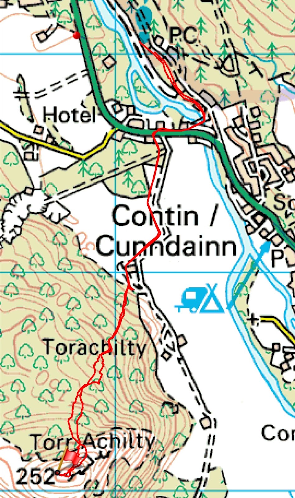
Start Point: Community Land car park to SE of summit.
Distance and Ascent: 4km and 290m
Weather: low cloud and light rain (of the sort that really soaks you).

Looking out first thing in the morning to find that the cloud was so low that we couldn't even see the far side of the road adjacent to which we were parked, I was thankful that I'd been up Meall Tairneachan in the sunshine yesterday afternoon. Originally I'd planned to do it this morning, before going on to the more modestly sized Dún Coillich, and it would undoubtedly have been a miserable and largely unrewarding outing in the conditions prevailing.

So that left me with just Dún Coillich to tackle, which I was confident was going to be quick and easy, given that I'd read that there was a waymarked trail leading from the 'community land' car park all the way to this summit. It was the knowledge of the waymarks and a path the whole way that had me decide to go packlessly, taking just my phone, so as to reduce the amount of stuff that would need drying afterwards.

The waymarks turned out to be so plentiful that it would take a serious lack of attention to get lost...

Green with white dots trail to the right (the one I was taking), green and white stripes straight on.

...but whereas I'd pictured an engineered path, the reality was a narrow trodden line variously through grass, heather, bracken and bilberry. Aside from the amount of moisture that got transferred from the plant life onto my legs, I had no complaints about the nature of the path. I did, however, have a slight beef about the weather. In view of the wetness, I was wearing full Paramo, and with the temperature having risen so much compared to the rest of the week, I soon found myself seriously aglow.

The angle of incline can't have helped with temperature management (I had all of my vents open and, at one point, my sleeves pulled up, in spite of the rain), although I didn't come to notice how steep sections of it were until I came down them. No wonder I'd felt so slow on the way up!


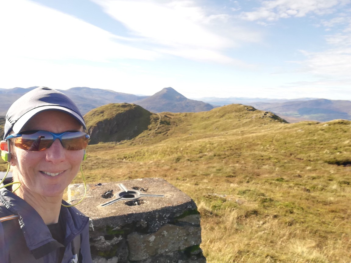
With no reason to tarry at the summit, after taking a couple of snaps, I hotfooted it back to Bertie. There I returned the map leaflet, showing the waymarked trails, to the leaflet box and looked around to no avail for a donation box for the community trust that has provided such a good recreational amenity.

That's the last hill of this trip. I wonder if I'll be able to squeeze any more in this year?

Thursday 7 October 2021

Wednesday 6 October - Schiehallion and Meall Tairneachan

Schiehallion (NN713547; 1083m)
Start Point: Braes of Foss Car Park (£2 all day).
Distance and Ascent: 10.8km and 750m
Weather: Excellent, if a bit cool first thing.

We were just up the road from Schiehallion yesterday morning when I noticed that the forecast for today was excellent. In the middle of a week of wet windiness, we were to have a day of calm sunshine. It thus seemed to me that it would be wasteful not to grab the opportunity to pop up the most notable hill hereabouts.

Knowing it to be a popular hill, we opted for an early-ish start, arriving in the Braes of Foss car park at ten to seven, just as it was starting to get light. That gave us the pick of the spaces, as we were the first vehicle there, although only by about a minute.

A couple and a singleton set off up the hill before us and got a good headstart as we first paused for breakfast, following by a period of bag-faffing, before getting ourselves out the door at ten to eight.

The summit was hidden by cloud as we ascended and we started taking guesses as to what time it would clear (11am, I reckoned, when we were on our way back down). By and by we gained height (always a good thing when visiting a summit!), climbing up to meet the cloud. At least we'd had a good view for the first 600m of ascent, we said. 

To our surprise we soon popped out above the cloud and by the time we reached the top the cloud below us was breaking up considerably. We thus sat on the summit picking out places we've walked before (most notably our TGO Challenge route from 2009).

Above the cloud

Fine sky up here! 

After a flask of coffee, and a chat with the singleton chap who'd set out before us (along with his 10-month old dog, whose first Munro this was), it was time for the inevitable: we had to face the horrible bouldery rockiness in the other direction. 

Selfie at one of the possible high points. Cairn where we'd had coffee (and Loch Rannoch) behind me. 

I like a good boulder field, but this wasn't a good boulder field by my definition. The size of the stones was largely 'rocks' rather than 'boulders' (again, in my book; I accept that other people's definitions of these things may vary) and it went on for far too great a distance to be any level of fun.

We'd not long cleared the rocks when we met a chap (carrying nothing) and a woman (carrying a handbag). Her response to our greeting was "Is it really still morning*? I feel like I've been on this mountain for days.", which didn't bode well for her feelings when she got to the end of the excellent engineered path and onto the rocks. (*It was only 1030.)

My comment that the path wasn't as busy as I'd expected was premature. Just around the next bend the snake of people heading up commenced. We returned to a car park containing far more cars than there were spaces (i.e. they were abandoned on every bit of verge that was big enough for a car).

We, of course, took care to make sure that we parked neatly, so that we weren't taking up any more than one car's worth of parking space. Unfortunately, not all the cars were so considerate. I reckon you could have squeezed four cars in there if they'd parked better.

With the car park so busy, and people still arriving, we didn't stay put for lunch, as I would have liked, but freed up our space for a car that had just arrived.

Meall Tairneachan (NN807754; 784m)
Start Point: Lime Kiln Car Park
Distance and Ascent: 7.25km and 550m
Weather: Fantastic!

The reason that I'd wanted to have lunch at Braes of Foss car park was that I was minded to have Mick drop me off at the quarry track, about 2km north along the B846 from the Lime Kiln car park. Mick could then return to the Lime Kiln and I would walk a horseshoe to finish there. That would have made my walk up to Meall Tairneachan easier (track almost all the way and no undulations).

Of course, I could still have asked Mick to drive me there after lunch (and he would have obliged, because he's a jolly nice chap is Mick), but by then I'd had a change of plan. This hill wasn't originally on the agenda for today, but as we were back from Schiehallion well before noon, and given how good the weather was, it would have been a waste to sit around in my PJs for the rest of the day, only to trudge up this hill in the rain tomorrow. However, I wasn't entirely sure how much I really wanted the extra exercise today, and if Mick dropped me down the road, then he would immediately have to drive off, removing any easy way for me to abort the outing. If I ascended from the Lime Kiln instead, then if I found legs or head to be unwilling, I could simply turn back.

Happily legs and head were perfectly willing and the going was pretty friendly too (an ATV track to NN78593 54527, then relatively easy walking through not-too-deep not-too-tussocky bilberry and heather), even if it was a bit more undulating than I'd noticed from my quick glance at the map. (I'm sure the descents on the outward leg wasn't as big as the re-ascents on the return!

Looking in this direction, the landscape put me in mind of the Rhinogau

My opinion by the time I reached the trig point... 


...was that this hill is far nicer and more pleasing a walk than Schiehallion had been this morning. Whilst Schiehallion is undoutedly a striking hill to look at (if viewed from an angle from which it presents itself as a conical lump), I personally struggle to see any other reason why it's so popular. It probably goes without saying that I didn't see a single person (even from a distance) on Meall Tairneachan.

Another benefit of this hill over Schiehallion is that it has Schiehallion in its view (as well as a huge number of other lumps and bumps, on such a clear-aired day)

Monday 4 October 2021

Monday 4 October - Meall na Leitreach

Start point: Small parking area next to the level crossing at Dalnaspidal
Distance and Ascent:  8.3km & 430m
Weather: A promising start, but deteriorating to rain and low cloud as we ascended, only clearing for brief periods for the latter part of our return leg.

I'd somehow missed this low-hanging-fruit of a hill adjacent to the Drumochter Pass on our previous trips up and down the A9, but having noticed it during my map perusals on Sunday, I put it on the agenda for today.

A group of six set off up the track just a minute before we stepped out of Bertie, and got a head start on us as the level crossing lights turned red just as we finished locking Bertie up (after not a single train had passed whilst we'd been sitting there having a pre-walk cup of tea). We soon caught them up and discovered they were off to a Corbett further up the glen. 

For us, we veered off to follow an ATV track (horribly soupy in places, but easier than yomping through heather) that led us up to, and then along, the ridge. All we then had to do was to veer off on the trodden path for the final 100m or so to the summit cairn.

In an unfortunate repetition of yesterday's outing, after a promising start to the day, the cloud had descended as we ascended and a prolonged shower had hit. At least it wasn't windy today, but it would have been nice to have had a view from the summit as, once again, we knew it would offer a good one. 

I predicted the summit would be clear by the time we were back in the glen, and so it was, although the showers continued at regular intervals. Thank goodness, once again, for Bertie's shower room being so well-suited to housing wet gear!

Decent weather as we started ascending

Summit selfie

Cloud finally starting to lift as we're on our way back down

Rainbow

Sunday 3 October 2021

Sunday 3 October - Meall nan Eagan (NN596874; 658m)

Start Point: Pull-in on corner of minor road and A889 to N of Dalwhinnie.
Distance and Ascent: 11.25km & 400m
Weather: More rain than dry, with a very small amount of sun. Windy on top.


In the middle of October 2019 we set out to walk The Fara and Meall nan Eagan, but were thwarted on the second half of the walk by a shoot in progress. Finding ourselves just up the road from Dalwhinnie this morning, I thought we'd have a second go at it.

The fact that we were close and that it made sense to go and bag it was in conflict with an attack of laziness and it took us most of the morning to get over the latter issue to finally get out the door to head in the direction of our hill.

Once off the road and heading up the glen, we took the lower track to skirt the estate buildings and just the other side I suggested climbing back up to the upper track. We were just about to do that when we remembered that the track forded the river a few times, which made us think we should stay low after all (neither track is marked on our aged 1:50k mapping). It was only when the track crossed the river for the third(?) time, and a landslip impeded our progress on the N side, that we climbed up higher and found that the upper track was a much better bet, albeit it soon descended and forded the river again.

At each of the ford points there was a bridge, however, they aren't permanent and are currently all laid parallel to the water, thus being of no use to us. We weren't inclined to wade, so we just stuck to the N bank. It wasn't difficult terrain.

Not bad weather on the walk in. Overcast, but decent clarity.

Crossing a flat expanse that wasn't as boggy as I'd feared it would be from a distance*, we were finally at the point of being able to attack the hill. As is often the case, we stood looking at it, discussed and agreed the best looking ascent line, then ignored everything we'd just said and headed straight up.

Until we were about half way up that final climb, we'd only caught the edges of a couple of showers that were so light as to not get us wet. Then it started raining in earnest and, with remarkably bad timing continued until we were back down in the glen again. So, our visit to the top was brief so as to minimise the time spent getting blown about and lashed by the rain. 

Not the best summit selfie ever taken. As seen behind us, with the rain came curtailed views; a pity as it'd be an excellent viewpoint otherwise.

It's a pity the sunny interval that followed the rain didn't save itself until the final ten minutes of our return leg, so we could have dried off a bit before getting back to Bertie. As it went, the respite from the rain was brief and we dripped our way back into Bertie's layby. His shower room is now festooned with wet stuff that doesn't stand much chance of drying in today's temperatures (daytime high of 9 degrees) and the afternoon's forecast sunny intervals have not materialised.

(*Bog wasn't an issue for me today as I'd decided (unusually, for me) to wear boots. Mick, however, had discovered as he was shoeing up for the walk that whilst the boots he'd bought could be described as a pair (there was a left and a right and they were both Salomon's), they didn't match, one being old and holey and the other being what he intended to bring. Quite how neither of us noticed in the process of packing that he was bringing one black and one green boot, we'll never know. As a result, he wore his trail runners.)

Thursday 30 September 2021

Carn Faire nan Con, Torr Achilty and Cnoc Mor

Carn Faire nan Con (370m; NH395591)
Starting Point: Layby on A835, 400m north of the obvious access track for this hill.
Distance and Ascent: 5.5km; 330m
Weather: Dry but mainly overcast


The first of three out-and-back hills today. Mick, scarred from yesterday's experience, opted to sit this one out so I was on my lonesome as I huffed and puffed my way up the pylon-maintenance track that was to lead me a good distance towards my hill. On reaching the high point of the track I was heartened to see a faint ATV track leading through the heather and tussocks that lay between me and my hill. It didn't remain helpful for very long, then it was a slog through pretty rough terrain, during which I wondered whether I'd accidentally dropped my hill fitness somewhere on my way up. Or maybe I just lost it over the last couple of months. Either way, it was a harder ascent than it ought to have been.

The fine viewpoint of the summit was, however, worth the effort:


Excuse the fact that I'm obscuring the view in the first snap.

A retracing of steps (more or less) had me back at Bertie ready for elevenses, but as the layby didn't have any separation from the fast-moving traffic, I put a pause on coffee and butteries, and we headed off to a forestry car park near Contin.

Torr Achilty (252m; NH447550)
Starting Point: Forestry car park N of Contin.
Distance and Ascent: 5.5km, 250m
Weather: Some sunny intervals, and the edge of a shower right near the end.


By the time we'd moved to this car park and had elevenses, it was lunchtime, but thinking this would be a quick 1-hour job*, I postponed lunch until my return.

Mick came with me as we walked back to the main road, across to the track-end where most people park for this hill, and up the farm track to the point where I stepped over a fence to attack the hillside. Mick then turned back, as I headed off into the bracken.

Thanks to cattle, there were easy routes to be found through the bracken, and the initial going once I reached the natural woodland wasn't bad either. It was only as I was reaching the top edge of the woods that the going became really rough. Routing myself such that I had to negotiate a couple of very small crags didn't help, nor did the fact that I was stopping far too often to flick a dozen or so ticks (each time) off my trousers. Definitely the biggest tickfest I've ever encountered!

The easy-going bit of the woodland

It was only once I was on the small plateau that the heather was short enough to make the going easy, but by then it was just a hop, a skip and a jump to the cairn marking the high point.

What views! I'm not sure Mick would have appreciated the roughness of the upper reaches of the woods, but he certainly would have enjoyed the views from up there.


I wondered as I set off back down whether any of the showers I could see would hit me. Obviously, I hoped they wouldn't, but at the same time, given the forecast, I couldn't believe I'd stayed dry thus far.

The descent seemed as slow as the ascent had been, as I picked my way carefully down, until finally I was able to hop a fence back onto the track.

About half way along that track the rain finally hit me and although not heavy it looked like it was going to last long enough to warrant some waterproofing. I opted for my 'disposable' (allegedly; I've had it since 2008!) poncho. An underrated item, I reckon, as it kept both me and my pack dry, even if I undoubtedly looked a bit silly wearing it. 

(*1hr36 was what it took. Surprisingly over 15 minutes slower than the first hill, even though it was the same distance.) 

Cnoc Mor (269m; NH490569)
Starting Point: Forestry car park at Blackmuir Wood, at the S end of Strathpeffer.
Distance and Ascent: 3.25km; 170m
Weather: Dry with some sunny intervals


I could happily have left this hill until tomorrow, but having decided to comply with Forestry Scotland's polite requests not to park in their car parks overnight, and with the absence of other overnight options nearby (that we knew of, at least), it made sense to do this hill today.

It was by far the easiest of the trip. Aside from the short distance and small amount of ascent, there was a path the whole way (even if I did initially walk about ten paces past it as it left the forest track).

Alas, there wasn't a view from the top...

I reckon this was the highest point, although I did also visit the trig point, which is a bit bleached out, but just visible on the other side of the fence.

...but I didn't have to detour far to be able to see beyond the trees:

Another retracing of the steps took me back to Bertie, although not without pausing for a few snaps of the wood carvings outside one of the houses alongside the forest track:

Just a small representation of the collection; I would guess that the owner has a chainsaw and an artistic bent.

----------
Incidentally, we would have gone up Ben Wyvis (Munro) today, if it hadn't been for such an unfavourable forecast. I know I didn't go high today, but based on my observations, the weather would have been perfectly acceptable to head up above 1000m. Harrumph.

Wednesday 29 September 2021

Mount Eagle (Black Isle; NH648590; 256m)

Start Point: Car Park on the A832 just E of Munlochy.
Distance: 17.2km
Weather: Mainly fine and sunny, but with a few drops of rain from a nearby shower when we reached the trig point.

I've put some navigational notes at the bottom of this post. Whatever you do, don't follow out outward route to the summit. The return route is definitely the way to approach this hill!

We contemplated driving up the little yellow roads to reach the car park nearest to this hill, but my brief look on StreetView suggested that might be a bit stressful in a Bertie-sized vehicle, and anyway, we were happy to make a longer outing of it, starting at the main road. (Having now travelled those roads on foot: they're perfectly wide enough, with plentiful passing places and we would have had no issue taking Bertie up there).

The amount and speed of traffic on the main road was off-putting, but a small section of what was once, according to the map, a railway bed, allowed us to avoid all but a little bit along the busy road, before we turned off onto the minor roads (which were surprisingly well used, but not problematically so). We jogged the flats and downs and walked the ups, until eventually we reached the big mast and the entrance to the forest.

Once on the forest track, left at the first junction, then right at the T-junction were the directions I'd noted, but on reaching the T-junction it looked like maybe the muddy track opposite us, recently made by heavy felling machinery, may be of use. I had a little look and decided against, continuing instead to the small masts.

There we made (in hindsight) a bad decision, opting to follow a trodden line, then another forestry-works track, to skirt the hill to approach the summit from the NE. Here's a more detailed map snippet of that section of the outing, showing quite how circuitous a route we took:

The trig point was our objective. 

We were within 100m of the trig point when we left the fire break and headed into the trees... 

Trying to find our way through the trees, picking our way over the monster lumps and troughs of the old stumps, all nicely disguised by a bed of heather. 

...I think that it then took us (incredibly and ridiculously!) over 30 minutes of thrashing around to get within 20m. At that point I did something I've never done on a hill before: I'd carried my jeans with me and now I put them on (on top of my running tights). We'd reached the dense gorse I'd read about, which turned out to be head-high in places. The jeans (and in Mick's case his walking trousers) provided valuable protection to the legs.

Fortunately we didn't do any more walking around in circles, but managed to dead-head to the clearing in which the trig point sits. 

The 'clearing' was clear of trees, but not from out-of-control gorse. 

Summit Selfie. No photo of the view, because this is a Marilyn without a view.

We weren't daft enough to go back the way we'd come. Instead we followed the trodden line, which was faint in the extreme, but brought us out without any prickling, thrashing, ducking or clambering, on the mud track, from recent forestry works, that I'd discounted on our way up (although even if we had gone that way there's no chance at all that we'd have spotted the faint line and cut off into the trees in the right place).

There we stopped to remove our extra trousers and jogged back down to Bertie, taking a slightly shorter route having decided that the track opposite which he was parked (which looks on the map like a farm track, that heads straight through a farmyard, and thus would be excluded from Scottish access rights) is actually a public road. Whether or not that assessment was correct, we made it through without being accosted by person or animal.

With the complete lack of a view from the summit and the issues with reaching it in the first place (admittedly we didn't make the job easy for ourselves with our approach choices), this hill has the distinction of going straight into my "Top 10 Worst Hills Ever".

(Navigational notes: At the T-junction SW of the summit (at NH64759 58739) go straight on, following the righthand edge of the felled area. With trees again on both sides, at a tree-stump (ha! Good luck with identifying the right one!) at about 64873 58936 head off left into the trees. The line on the ground is really faint, but it leads to, and continues through, the gorse-hell clearing. If taking this line extra trousers aren't currently required, as the trodden line continues through the gorse reducing the prickling potential.)

Wednesday 7 July 2021

White Hill

Sunday 4 July
Start: Highfield Certified Location campsite, Lochmaben
Distance: 10km
Ascent: 260m

On Friday I’d perused the map, trying to find a suitable hill to visit on our way home. I’d selected Hill of Wirren (which we’d been up on Saturday), as it met the requirements I had as to distance and terrain. However, during that process I noticed that I had a hill unbagged just a few miles west of the A74(M). It confused me for a while as I could remember visiting a marilyn thereabouts, and there wasn’t another one marked on the map. I also established that I hadn’t been up a hill by that name. A bit more digging revealed the truth: a few years ago I had been up Hightown Hill, which neighbours White Hill, but an intervening survey had promoted White Hill in place of Hightown as the Marilyn summit.

Examination of the gpx file I’d recorded on my visit to Hightown Hill in 2018 disclosed that our route off the hill had taken us to within 100m linear and 20m vertical of the top of White Hill. How annoying that I didn’t notice at the time how close the two tops were in height, as if I had I’m sure I would have nipped up it by way of insurance. As I hadn’t, the Certified Location campsite at Lochmaben benefitted from our repeat custom, so that I could get up on Sunday morning and trot off up the lane to bag the ‘new’ summit.

I didn’t form a lollipop of a route this time, but did a simple out and back through sheep and cow pasture of grass of lengths varying between ‘cropped’ and ‘knee high’. After overnight rain, my shoes were soon squelching.

On the way up some cows looked like they were vaguely considering whether it was worth the effort of coming all the way across the field to investigate this stranger passing through their home. On the way down it had started to rain and they’d all decided that lying down was the best place to be.

The rest of my return was entirely uneventful. Notwithstanding the dampness, it was a pleasant leg-stretch before a few hours of driving. 


The high point mid-snap is Hightown Hill, atop which I stood in 2018


View (at least the cloud had ascended with me; when I set out the top had been covered) 
 
The notable difference between outward and return routes is where I went through a different gate on the way back (by inattention, not by design!)