SectionHiker is running a series on the subject of 'Love on the Trail' this week, featuring interviews with five backpacking couples. Mick and I will be Wednesday's couple, whereas today the series kicks off with Beardoh and Sweetpea.
If any SectionHiker readers happen to have found themselves here on our blog for the first time then (hello!) I would point you in the direction of the links over on the right (on the desktop version of the blog) which link to our various long walks. It seems I'm overdue adding links for our PCT and GR10 section hikes (July 2012 and July 2015 respectively), which is something I can't rectify right now as we drive back to the UK from Spain (where we've just spent a couple of months touring in our motorhome) with only my phone for Internet access.
Monday, 29 February 2016
Wednesday, 24 February 2016
24 February – Route PR-BA 112: Cruz de los Martires – “Pino la Junta”
Until yesterday, when we’ve gone into a Tourist Office and asked for information about local walking trails we have been given either a high-level map (sometimes very high level, just showing the area where walks are available) or a page of route details, often photocopied. One office could only sell us a map for €5, which didn’t quite cover the area in which we were interested (an information sign outside was much more useful and I just photographed that instead). So, when the assistant in the Tourist Office in Fregenal rummaged under her desk and came up with a glossy cardboard envelope containing six glossy route cards, I expected there to be a charge. Nope; our good friend “EU Funding” has been in play again, resulting in the creation of the routes and of the (full-colour, high-gloss) information about them.

I selected two circular routes out of the six as contenders for this morning. Mick’s choice was a third, a lollipop-shaped trail, which also happened to have the start point nearest to Colin and that’s the one that won the toss.
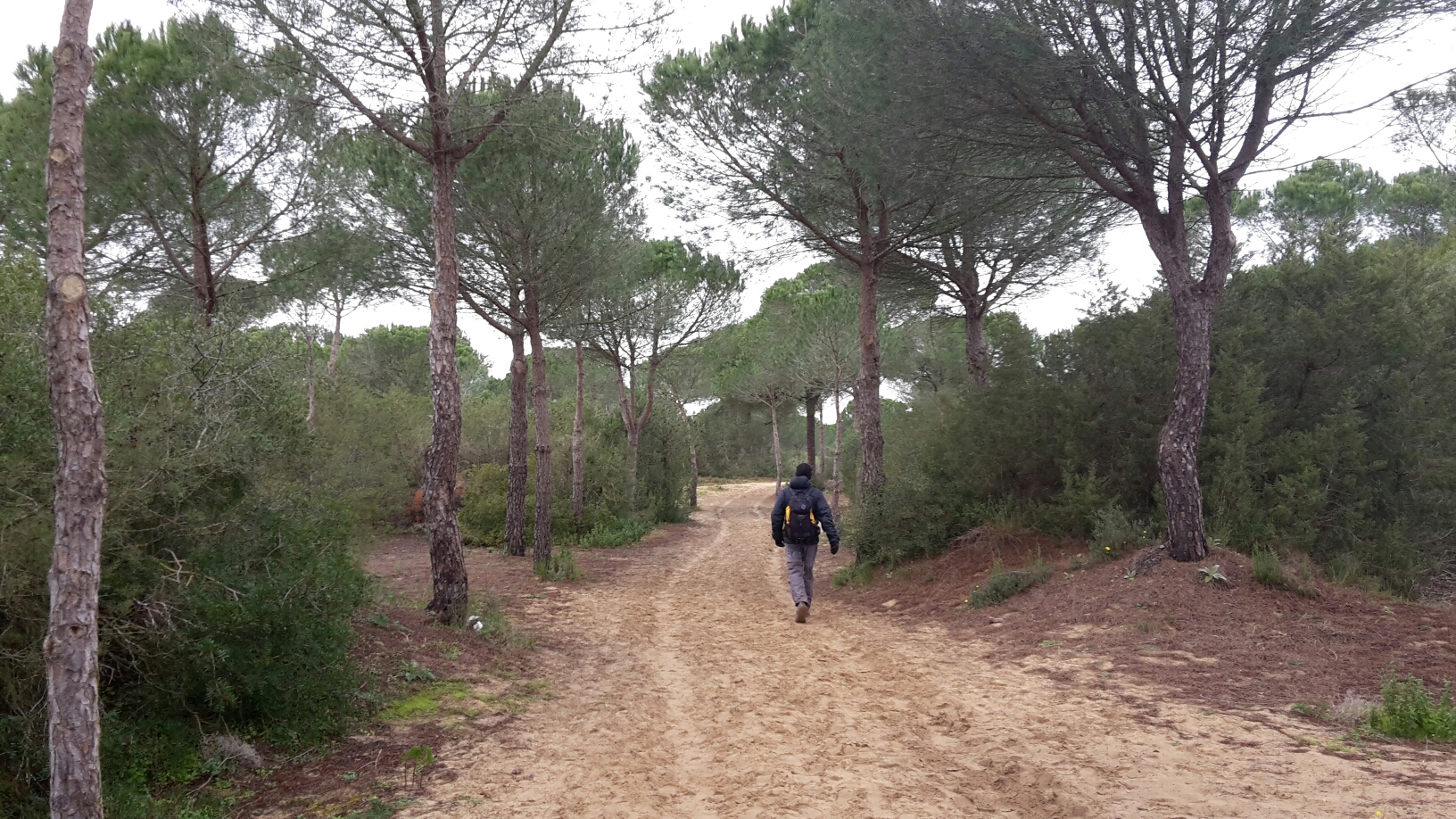
A cloudy start saw us exit the bus station (where the motorhome Aire in Fregenal is located) and wander a few hundred metres up the road, where our way lay up a dirt road (when I say ‘dirt road’ I mean a public road, complete with sign posts, but unsurfaced; it wasn’t busy with traffic). By the time we got to the point where we left the road to take to a track running adjacent to the railway, the sun had won through:

Another track took us back to the dirt road, which formed our return route. As the route card had suggested, it was a fast-going trail, with the 7.9 miles taking us just two and a quarter hours. As with yesterday’s outing, it was a perfectly pleasant countryside walk and a good stretch of the legs (and with much greenery and dry-stone walls it was, again, reminiscent of home), but it wasn’t spectacular. I suspect we would need to be a bit further east, into the Sierra Morena, to obtain more noteworthy walking.
We won’t, however, be heading east. With our time in Spain drawing to a close, and with a couple more towns/cities we want to visit lying between us and home (not to mention an awful lot of driving), today’s was probably the last walk of this trip which will qualify for a mention on this blog. I will, of course, continue wittering away about our other doings on thegateposts.blogspot.com.

I selected two circular routes out of the six as contenders for this morning. Mick’s choice was a third, a lollipop-shaped trail, which also happened to have the start point nearest to Colin and that’s the one that won the toss.
A cloudy start saw us exit the bus station (where the motorhome Aire in Fregenal is located) and wander a few hundred metres up the road, where our way lay up a dirt road (when I say ‘dirt road’ I mean a public road, complete with sign posts, but unsurfaced; it wasn’t busy with traffic). By the time we got to the point where we left the road to take to a track running adjacent to the railway, the sun had won through:

Another track took us back to the dirt road, which formed our return route. As the route card had suggested, it was a fast-going trail, with the 7.9 miles taking us just two and a quarter hours. As with yesterday’s outing, it was a perfectly pleasant countryside walk and a good stretch of the legs (and with much greenery and dry-stone walls it was, again, reminiscent of home), but it wasn’t spectacular. I suspect we would need to be a bit further east, into the Sierra Morena, to obtain more noteworthy walking.
We won’t, however, be heading east. With our time in Spain drawing to a close, and with a couple more towns/cities we want to visit lying between us and home (not to mention an awful lot of driving), today’s was probably the last walk of this trip which will qualify for a mention on this blog. I will, of course, continue wittering away about our other doings on thegateposts.blogspot.com.
Tuesday, 23 February 2016
Ruta 10(ish) – Valverde del Camino
Our first peek out of a window this morning showed us not just clear blue skies, but good visibility; the dust cloud had gone. Excellent!
It was Route 10 that I’d chosen for today and having searched Wikiloc for the corresponding gpx file I’d found one that looked approximately the right shape and length, and with the same start point, as the line shown on the official route map. I didn’t go as far as to do a detailed comparison between the file and the official map, as it was a bit of a faff to keep flicking between them on the screen of my phone, so it wasn’t too much of a surprise to find mid-walk that we had deviated from the official route.
Unlike yesterday’s outing, which started right at the opposite end of the town, today we could see the first waymark as soon as we stepped out of the warmth of Colin and into the slightly chilly morning. Within a few paces we were on an ex-railway bed, with views :-). Leaving the almost flat, often straight, track to go through a tunnel under a road I discovered for the first time (after 9 years of ownership) that tunnels and light-reactive glasses are not happy partners: without my glasses on I could see bugger all in the tunnel; with them on (and still in their state of fully dark) I could see the same. Mick kindly guided me through the flooded sections and we both popped out dry-shod into the light at the other end.
It wasn’t much later that I commented that we hadn’t seen a waymark for a while. About two seconds later, I spotted a faded one on a rock to the side of the track. That was the last one we saw, even though, I now know, we were still on Route 10 at that point.
Up to nearly the top of a hill the forestry-type track took us, with a fine view opening up before us:

I now know (having studied the official map in more detail after we finished the walk) that it was at the next junction, where we took to a dirt road, that we diverged from the official route. That wasn’t a problem – it was always going to be easier to follow the gpx track I’d downloaded than to play ‘spot the waymark’, particularly given that we’d only seen one in the previous half an hour.
The area around Valverde (in as far as we’ve seen it) isn’t spectacular, but it’s very green, pleasant and rolling and we went over a couple more of those undulations, and past a couple of pretty ponds (we scared a stork into flight at one of them and we heard the arc as it flew into an electric cable; it appeared unscathed as it turned and went off in the opposite direction) before finding ourselves back on the railway bed for the last few hundred yards to Colin.
The outing came in at 5.5 miles, with an official ascent statistic that I don’t believe at all (1600’).
Monday, 22 February 2016
Ruta 3 – Valverde del Camino
After a couple of days in Seville, we left under a cloud of sand and dust and headed west to Valverde, a place I was going to omit until I found, on the town’s website (www.valverdedelcamino.es), that there are 10 walking/cycling routes here. In the absence of a summary on the website it was a bit of a painful process to find out their lengths, where they lie in relation to the town and which are circular, but after a bit of perseverance I had found and downloaded gpx files for three options.
This morning we set out for the longest of those I’d selected, which was made even longer by virtue of Colin being parked right at the other end of the town to where the route started.
Walking down a lane, between stone walls, and with green undulations and trees forming the view to each side of us, we could have been in England …

…if it hadn’t been for things like the storks sitting on nests on top of some nearby pylons. There was one on top of a chimney in the town too:

A dirt track between grazing pasture, complete with inquisitive young cows was also reminiscent of home…

…although walking in temperatures in the high teens at this time of year was rather less so.
The main attraction of the route I’d chosen for today is that it visits the remains of six dolmens (chambered burial cairns), although reports I’d read on-line suggested that only four were findable. We found (or didn’t find…) the same, although things might have been easier if all of the information signs hadn’t been removed, damaged, and scattered around the area:

Below was the most interesting, I thought, of the four we found, but if you look carefully you might see that a chap called Juan has daubed his name over one of the stones in yellow paint. He’d done the same on all of the sites, one of them repeatedly. As I said weeks ago, even ancient remains aren’t safe from graffitists in Spain. I wonder if he was the person who thought it’d be fun to remove all the information signs too?

We still had over half of the walk to go after the dolmens (I’d expected to find them scattered around the route, whereas the reality was that they were all grouped together on an out-and-back detour from the circuit), which took us through more pasture. It was on that return leg that we noted that thus far we had seen flies, spiders, birds, cats, dogs, goats, (sheep, mules,) horses and cows, but not a single old lady.
Lunch was had under the shade of a tree at a point where I’m sure that on a clear day the view would be superb. Alas, we’re still sitting in a dust/sand cloud, severely curtailing visibility (although nowhere near as much as when we left Seville yesterday).
A cycle path completed our circuit back to the town, through whose streets we retraced our steps back to Colin. Nine and a half miles had been walked, and ViewRanger tells me that the undulations added up to 1000’. I strongly suspect the ascent figure is exaggerated.
Friday, 19 February 2016
19 February – Doñana
The Parque Nacional Coto de Doñana mainly comprises a large road-free chunk of wild-life infested marshland and, having read about the place (including a visit to the Visitor Centre whilst we were in Sanlúcar de Barrameda), I would very much have liked to explore it, but the only options for so doing involved organised boat and/or Jeep tours, which didn’t sound like my cup of tea. So, having found that a bit of the park extended to the Sanlucar side of the river, and that there was a short walking trail there, we decided to go and take a look.
We seem to have had an awful lot of rain over the last couple of weeks and it was raining again this morning as the SatNav took us on an ‘interesting’ tour of Sanlucar featuring one particular road where we cleared the parked cars with just inches to spare (and that’s not to mention receiving many a direction to take us the wrong way down one-way streets; it’s a good job we were paying attention to the road signs and ignoring the SatNav!).
After a far longer journey than a 10km distance would usually take, we arrived in the car park just as another shower was upon us. Feeling sure that it was going to clear up any minute (mainly because that’s what the weather forecast had said) the usual delaying tactics of coffee and toast were again employed. It worked! Whilst we did get a few spots of rain on us, our walk was largely in the dry.
For reasons that baffle me, the route we were to follow doesn’t start from the car park, but from about 100m beyond it, next to this lagoon:

As the information sign is located, and the waymarks also start, 100m from the car park, unless you know about the trail and in which direction to head to pick it up, you could easily miss the fact that it exists. Fortunately, I was armed with the map tile on ViewRanger and the gpx file.
Initially a sandy track was our walking surface…

…which took us (with ash falling on us like light snow) past lots of workmen removing the lower branches of the pines and burning the piles of offcuts, before we turned and found ourselves on a narrower sandy path:

The highpoint of the route was a dizzying 18m above sea level, which was high enough to put us just above the tops of the surrounding trees:

The 3.1-mile circuit took us a little under an hour and was sadly lacking in many signs of life beyond a couple of school groups. There was a variety of bird-life on the lagoon, but that was it and I came away not feeling like I’d had any sort of a taster as to what the bulk of the park, on the N side of the estuary, is like.
We seem to have had an awful lot of rain over the last couple of weeks and it was raining again this morning as the SatNav took us on an ‘interesting’ tour of Sanlucar featuring one particular road where we cleared the parked cars with just inches to spare (and that’s not to mention receiving many a direction to take us the wrong way down one-way streets; it’s a good job we were paying attention to the road signs and ignoring the SatNav!).
After a far longer journey than a 10km distance would usually take, we arrived in the car park just as another shower was upon us. Feeling sure that it was going to clear up any minute (mainly because that’s what the weather forecast had said) the usual delaying tactics of coffee and toast were again employed. It worked! Whilst we did get a few spots of rain on us, our walk was largely in the dry.
For reasons that baffle me, the route we were to follow doesn’t start from the car park, but from about 100m beyond it, next to this lagoon:

As the information sign is located, and the waymarks also start, 100m from the car park, unless you know about the trail and in which direction to head to pick it up, you could easily miss the fact that it exists. Fortunately, I was armed with the map tile on ViewRanger and the gpx file.
Initially a sandy track was our walking surface…
…which took us (with ash falling on us like light snow) past lots of workmen removing the lower branches of the pines and burning the piles of offcuts, before we turned and found ourselves on a narrower sandy path:

The highpoint of the route was a dizzying 18m above sea level, which was high enough to put us just above the tops of the surrounding trees:

The 3.1-mile circuit took us a little under an hour and was sadly lacking in many signs of life beyond a couple of school groups. There was a variety of bird-life on the lagoon, but that was it and I came away not feeling like I’d had any sort of a taster as to what the bulk of the park, on the N side of the estuary, is like.
Friday, 12 February 2016
Friday 12 February – SL-A 175 Failure at Benarraba

View from Colin, when the cloud isn’t hanging right down into the valley
Whilst today didn’t dawn fine, it was dry and with a higher cloud base than the last couple of days, so after I’d presented Mick with a postcard and sung Happy Birthday to him, off we headed to walk route SL-A 175.
Due to the location of the village of Benarrabas, this circular walk starts with the downhill and ends with the up. As much as I’d rather have things the other way around, this was the only circular trail in the area, so off we went – steeply down.
I commented a couple of days ago about how green and forested is the area in which we’re now travelling and today we learned that we’re in a cork oak area. It was these trees, just a few minutes into our walk, which initially gave it away:

and a while later (just as we were wondering how long it takes for the bark to regrow) we came across an information sign telling us that the valley side on which we were standing is split up into ninths, with one section being harvested each year on a 9-year cycle.

very green!
The down went on violently for some time until, after crossing a stream and ascending a little way the other side, I began to get suspicious that we weren’t on the right path. In fact, it seemed to me that we were on the wrong side of the valley. I’d not been able to find a gpx file for this route (and I now believe that’s probably because no-one has been able to follow it in order to record a track!), and the map on the official leaflet was so lacking in detail as to make it only of marginally more value than that on the information sign at the start point (which was a line on an aerial photo). However, the map on the leaflet (which I had downloaded onto my phone) did have some contour lines, telling us that we shouldn’t have dropped below 350m. We were now at 280m…
Back we went, huffing and puffing up the steepest section, to get to a multi-way junction we’d passed a while before. All possible alternative tracks were explored, without a single waymark being found and with none feeling right, before we conceded defeat and headed back the way we had come.
By then a light mizzly rain was falling, so any passing thoughts of trying the circuit from the other direction were pushed firmly out of my mind, and via the village shop (for the poorest imaginable excuse for a birthday cake) we headed back to Colin.
Having moved on to Casares, where there are plentiful walk options, Mick vetoed the notion of going out again, pointing at the rain being lashed at Colin’s windward window:

So, once again we hope for better tomorrow (only two more days before the forecast turns good again, but we’ll be back on the coast by then).
In the absence of another outing, the eventfulness of the afternoon has been witnessing a driverless car (and not in the manner of modern technology) roll backwards across the car park, coming to rest on a kerb and against some road signs. Mick managed to locate the owners in the Tourist Office – a couple from Basingstoke. They were quite relaxed about what had happened “At least it’s only a hire car!” they said.
(Note for anyone reading both this and my Colin blog over at thegateposts.blogspot.com: I've saved you some reading as I've lazily duplicated the same post in both places today.)
Monday, 8 February 2016
Natural Wonders at El Torcal
Parque Natural de El Torcal is described by the Rough Guide as being ‘one of the most geologically arresting of Spain’s natural parks’ and as Colin laboured his way up the roads to get there we could see that it was indeed spectacular – even though the views were somewhat curtailed by virtue of our having ascended into the cloud base.
The usual delaying tactics were deployed and a walk around the visitor centre had (the main point of interest being a small exhibit giving the history of how the landscape evolved) but even so, it was still in significantly reduced visibility that we set out. It was blowing a hoolie too, which combined with the fog and the altitude had us setting out dressed for a winter’s day in Scotland:

There are two trails leading from the visitor centre car park, one of which is 1.5km long with a time estimate of 45 minutes and the other 2.7km with a time estimate of 2 hours. We set out for the longer one … and arrived back in 30 minutes. We immediately knew where we’d gone wrong – we were trying to follow the yellow route, but the park, in its wisdom, had signed the colours at the critical junction in words, not by coloured paint. Not knowing that ‘amarilla’ is yellow, we’d followed the wrong colour.
No matter, we would have some lunch, hope that the cloud would finally lift, and head out for attempt two.
The cloud did lift and the surroundings became even more spectacular. It turned out that the yellow path (which shared the first and last half kilometre with the route we’d taken in the morning) was much more techical and demanding than the short route, adding even more interest and plenty of mud too; they had a lot of rain yesterday, we were told, making the shiny limestone rather slick in many places.
It’s going to be difficult to convey in my snapshots what the place was really like, as I think it has to be seen in person to be appreciated, but just imagine the sort of eroded limestone depicted below stretching out all around, for as far as the eye can see:


It wasn’t an arduous day’s walking – in fact, the two routes together came in at a total of just under an hour and a half (4.2km), including many a pause to take photos and to admire the shapes, but it really was a fantastic place to visit and a side-trip that I would recommend to anyone.
Friday, 5 February 2016
PR-A 354 - Sendero de Los Molinos y las Fuentes (West Section)
It was gone 2pm by the time we headed out to complete the route we had started yesterday (having done the cultural town tour this morning), making our way first back up to the Erimita de los Santos Martires, where we left the trail yesterday:

On our way there we answered a question that has been bothering us for a few days*: why does almost every olive tree have a plastic bottle, with a quantity of liquid in the bottom, hanging from it? Passing close enough to one of the plastic bottles today to be able to examine it, we found that it had a cap on (thus it wasn’t channeling and collecting sap from the tree), but it also had some holes punched towards the neck of the bottle. “Aha!” I exclaimed. They’re insect traps, presumably for some specific pest:

After a few minutes heading up a track the waymarkers told us to descend some steps, taking us to walk along an irrigation channel. There’s quite a system of them making their way through the terraces and orchards. Some of them look like they have fallen out of use (although I could be wrong there), and we have noted that modern hose-based irrigation systems are much in evidence:

Another surprise picnic area appeared before us, together with some steps leading up to a viewpoint. I visited the latter and can’t understand why they built it there – it must be one of the poorest vantage points in the area. Nevertheless, the Spanish certainly know how to built sturdy picnic sites, this being typical of all of the ones we’ve seen:

To loop back to Abla, down to, along a bit and across the river bed we had to go. A bit of mild directional confusion accompanied that bit; the waymarks were there, we just needed to look carefully for them:

As well as picnic areas abounding (we passed another on our way back to Abla), we’ve also come across a few outdoor gyms (although none as good as the one in Ohanes, which was incredibly well equipped). This one struck us as being oddly located, being about a kilometre away from the nearest house. There’s only three pieces of equipment here, and one of them is a walking machine; who’d want to walk at least a kilometre out and back, just to go on a walking machine?!

An afternoon walk appears to be a very popular pastime in the places we’ve been so far, particularly amongst the older women, and we duly got stared at by a few we passed (yep, Mick did greet them and make them all speak) as we made our way back to and through Abla.
My considered opinion, having now completed this route is that we were spoiled by the Mines of Berja trail the other day, as whilst PR-A 354 does have some good and pleasing sections, overall it just isn’t that interesting.
As for stats, we would have more success in recording them if we’d remembered to stop the GPS before we drove off in Colin… What I can say is that the advertised total of 2500’ of ascent for this whole trail was more like 700’.
(*I forgot to mention yesterday that we had solved another question which had been bothering us. Many terraces and orchards we have been seeing in this region are full of trees in pink blossom, but neither of us was sure what they were. Yesterday’s route took us straight past some which were still bearing a little of last year’s fruit. Almonds was the answer. Everyone seems to be growing them around here, with all of the terraces and orchards we passed over the last few days being planted with either almonds or olives.)
Thursday, 4 February 2016
PR-A 354 - Sendero de Los Molinos y las Fuentes (East section)
I’m getting better at sussing out where walking trails are available, particularly now I’ve found a couple of helpful websites*. My first knowledge of this one came about as we made our way gingerly down the last section of the pass to Abla yesterday (after a bit of an incident with overheated brakes), when I happened to notice a waymarker and we were going slowly enough for me to see that it was route number PR-A 354. The official route information was found and the gpx file downloaded, but we decided only to do one chunk of the trail today, cutting short by walking down a road (this isn’t a walking holiday after all, so short routes which can be fitted in before lunch are perfect).
After relocating ourselves from one of Abla’s motorhome aires to the other, we were perfectly positioned about ten yards away from the start of the route, which soon had us walking alongside an irrigation channel:

The first couple of kilometres or so were somewhat lacking in interest, taking us mainly through scrubland, close to the motorway. The land the other side looked better, and that’s to where we were headed:

If you ignore all the flyovers in this next snap, then you’ll see that Mick is walking along a dry river bed. All bar a couple of the rivers we’ve seen have been dry, but often very wide with evidence of signifiant water erosion, which suggest that the rain pattern is of the flash-flood variety. When do those rains occur? Is it summer thunder storms, as we don’t seem to be seeing much evidence of winter rain (albeit this winter may not be typical).

Just before finally crossing under the motorway (which, despite appearances didn’t happen where the above photo was taken, we veered off left at that point), there was one of the redeeming features of this section of the walk, in the shape of an old aqueduct, juxtapositioned against the wall of an elevated section of motorway:

The next snap has got itself a little out of order. I can’t remember exactly where it was, but it was definitely before the aqueduct, and it was one of the more attractive areas of the first section of the route, giving expansive views (including of the nearby windfarm). The building remains, at which Mick is looking, was obviously a big, grand place at one time:

This place wasn’t quite as grand, being a cave dwelling with a modern extension stuck on the front:
[Doh! You'll have to imagine it - I don't have access to that photo right now]
Then we were into the hills and climbing, although nowhere near as much as the official information about the trail had stated**, through an area containing an unexpectedly high variety of plant-life.

Having taken lots of photos of the scrubby first half of the walk, I failed to take many of the attractive second half – but it was jolly pleasant. Coming out on a road, right next to a church it was but a stroll back down the road to Abla and our start point. We’d walked 5.6 miles with around 500’ of ascent. Tomorrow we intend to go and walk the west side of the route***.
A stroll around the town/village was had later in the day, before we relocated back to our original aire (it’s a nicer and quieter place for spending the night … I say as somewhan starts beating a drum at the adjacent sports ground!). This snap shows a typical narrow street (this one having a fine view of snowy tops at the end of it). We reckoned we could have got Colin along this road without much bother. He couldn’t have tackled any of the side-roads though.

(* www.fedamon.com lists all PR-A routes by region, with links to the official data sheet, although I can’t find them depicted on a map, which makes it a bit arduous to work out if there are any in a particular area. Then there’s wikiloc.com, which I feel like half the world already knows about and that I’m late in discovering, but it seems to be a fantastic resource for finding other people’s gpx routes.
**The official route information says this trail has 820m of ascent. Looking at a map, I couldn’t see anywhere near that amount. It was as we stood looking at the information sign at its start point that we saw the elevation profile in detail and realised someone had come up with that number based on plotting a line on some electronic mapping and believing the number it came up with without considering the believability of the shape of the elevation profile. The route did not go up and down five feet in every ten paces as that elevation profile would suggest.
***The original text of this sentence said that we were going to walk the east side tomorrow (on the basis we had done the west side today). A debate broke out with my proof-reader, who thought I had those directions the wrong way round. I was so absolutely sure of my correctness that I couldn’t understand how said proof-reader was getting it so wrong. I brandished my phone, with the map and route displayed … darn it, my proof-reader was correct. Don’t you just hate it when that happens?)
Wednesday, 3 February 2016
Trail PR-A 336 – Minas de Berja
Our diversion to a supermarket yesterday afternoon took us to the town of Berja, where we pondered over our destination for the night. When it turned out that the coast was a little further than we had thought, I looked at the map again and realised that we were very close to another area highlighted to us by the lady in the Tourist Office in Almeria as being good for walking.
The night was spent in one of the car parks in the big recreation area, just a minute or so down the road from the start of a handful of walking routes. There were various possibilities for combining bits of different routes, but we opted to just follow PR-A 336 in its entirety, which the information sign told us was 8.6km long.
Well, what a fine walk that turned out to be! A narrow path took us via the remains of 7 sets of lead mine workings and an enormous slag heap, all the time giving us superb scenery and views (including the snowy high tops of the Sierra Nevada, to the north).
We retuned back to the recreation area having covered 10km (hmmm, are all of the official distances under-stated?) with just over 500m of ascent and having had such a good walk that I’m now very glad that an earlier error in grocery planning led us to take a diversion to Berja!

We’re going up there, somewhere

Nice path!

Fine views from the high point of the walk

Crossing the enormous slag heap. You wouldn’t have wanted to fall half way across, due to the steepness, but it was actually very stable to walk across.

Another shot of the slag heap – it must have been a few hundred feet tall and made of the sort of crushed-rock gravel for which people pay good money when they want to lay a driveway

One of the mine entrances. All of the others were just holes in the rock (some vertical, some levels), whereas this one had a constructed entrance.
Tuesday, 2 February 2016
Laujar de Andarax
The nice lady in the Tourist Office in Almeria, although unable to furnish us with any information as to walking routes in the area, did recommend to us two good walking locations and having spent last night only about 20km away from one of them, that’s to where we headed this morning. I had already downloaded from t’internet a GPX file for one walk in that area, but we arrived to find a sign detailing various different options. Instead of the 16km circuit for which I already had information, we opted for the 7.6km one, with the thought that we could always tack the 4.2km one onto the end of it, if we so fancied.

With the valley in which we parked being steep sided and running north-south, it can’t have seen the sun since the middle of yesterday afternoon and thus, even though we’ve not seen a hint of a cloud for 2 days, I set out wearing three layers and wishing I’d dug out some gloves. My hands were freezing by the time we finally found some sunshine (whereupon we promptly overheated and had to strip down to t-shirts).

What struck me as we made our way along the valley, and then started to climb up its side, was that after a couple of weeks of being surrounded by barren desert, we were suddenly somewhere green. Indeed, the river Andarax, which runs down this valley, is more than just a trickle, and the snow-topped mountain we had spied on our drive in suggested that these mountains see more precipitation than the surrounding plains (disproving the famous saying about the rain in Spain?).
The first half of the walk was uphill on tracks. In fact, technically, I think they are classified as roads, but to me they’re tracks. Then we were onto a lovely path, which took us through pine woods, sometimes descending infeasibly steep slopes via switchbacks and sometimes clinging to the side of the valley.

A worrying bit of uphill appeared before us at the point that we thought we were supposed to be making our final descent, but we were just being a bit impatient. A couple of minutes later, after another excellent viewpoint, our descent did start.

We’d already walked over 8km by that point (and still had a way to go), contrary to the 7.6km declared by the signpost at the beginning. We met another detailed information sign as we joined a dirt track back in the valley, which gave the distance as 9.6km. I measured it as almost exactly 10km.
Being such a pleasing walk we would happily have stayed another day to go and tackle the longer route tomorrow, but the empty state of Colin’s fridge and pantry dictated otherwise. We needed to go and find a proper supermarket.
Subscribe to:
Posts (Atom)


