The Road goes ever on and on; Down from the door where it began;
Now far ahead the Road has gone; And I must follow, if I can;
Pursuing it with eager feet; Until it joins some larger way;
Where many paths and errands met; And whither then? I cannot say.

[JRR Tolkien, Lord of the Rings]

Friday 30 September 2016

WCP: Ferryside to Pembrey

Friday 30 September

Distance: 14.1 miles

Weather: Sunshine and showers

I didn’t follow the WCP route out of Ferryside this morning, as it headed inland up over some lumpy bits, as I guessed it would probably involve yet more soggy farmland and another tedious game of ‘spot the gate’, so instead I took the coast road which, as its name suggests, runs along the coast. Five vehicles passed me during the four and a half miles to Kidwelly.

After a pause there for an enormous Belgian Bun and coffee, I had intended to continue on the WCP, as now it took a line nearer to the sea than the road, but I must have been away in la-la land, as I missed the turn, and by the time I realised it didn’t make sense to go back. I did, however, feel like I was cheating by taking the road-based shortcut, so when I got to the point where the WCP rejoined the road, I followed it in the wrong direction, then turned around and walked back again.

One of a number of rainbows were seen as I first glimpsed the sea on this out-and-back detour:

20160930_091222

Back on the road, I was soon on my way into Pembrey Forest and after what seemed like an awful lot of wiggling around I finally reached an exciting point: as I dropped onto the beach I made the final turn of the trip. This beach was going to lead me all the way to where I finished my walk from Chepstow to Pembrey in March 2015…

20160930_10462720160930_104630

What a fantastic place to finish a Welsh Coastal walk!

…or so I thought. It was only when I turned inland to find Mick that I started to worry that nothing looked familiar, and after a further exploration of the map I realised that I had been mistaken about the route I had taken previously. It was soon solved with a quick out and back walk, which took me to this point, where I’d definitely been before:

20160930_120833

And that was that. Over the course of a number of trips, I have now walked the whole of the way around the Welsh Coast, including Anglesey, and even though a couple of the last few days have been less than fun, they have been very much the exception. Now, which bit of coast shall I make into my next project?

WCP: St Clears to Ferryside

Thursday 29 September

Distance: 25.8 miles

Weather: Sunny intervals

Yesterday afternoon I walked up the River Taf to the nearest crossing point at St Clears. Today I crossed the Taf, strode/splashed/waded all the way down to the coast at Wharley Point, before heading inland again to cross the River Tywi at Carmarthen, so the reality was that only a few minutes of the day were really on the coast.

The WCP does, however, try to keep as close to water as possible, except where the route nearest to water is a pavementless A or B road, whereupon the path tends to take a more indirect route through fields. It is perhaps for those reasons that this section seemed to be little walked – and even I gave up with the official route after a while.

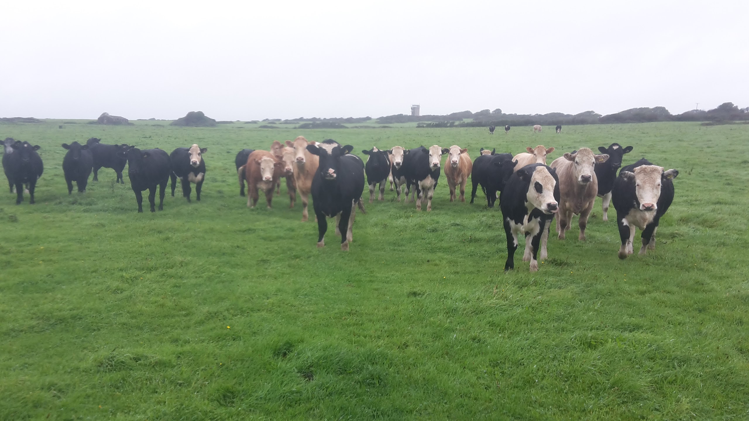
The first bit that irked me, after I’d already slogged through fields of cows and long wet grass, playing ‘spot the gate’ was this:

image

I was annoyed with myself as much as the route planners. Why does the route do that big V instead of just following the right of way which goes across the top edge of the inverted triangle? And why had I not followed the line I’d plotted on the map, which did take that top edge?

The next bit which was ‘interesting’ was also my own fault to an extent, in that the route shown on my 2014 1:50k map had changed to a longer road-based walk by the time my 2016 1:25k map was published. However, when I got to the turn for the 2014 route there was a WCP waymarker and a gate so I followed it and soon found out why the route had been changed. That field was a serious muddy bog, with one water obstacle into which my walking pole disappeared right up to the handle. I did, however, find a way across that obstacle without going in much above my ankles, and I was sure that once I cleared that field the going would get better and drier.

It didn’t. I sent a text to Mick comparing it to walking in the Everglades, but with more cowpats and fewer aligators.

Back on the current WCP route, things didn’t get much better and it was here that I noted the first indications (after having to climb a few 5-bar-type farm gates which I couldn’t easily open) that few people come this way, like this WCP gateway:

20160929_084519

I did get a bit of a watery view on this section…

20160929_091630

…but it didn’t seem worth the trouble, so I vowed to stay on roads for the rest of the day.

My resolve remained for a while, although in part because I strode straight past the next turn without even seeing it, and I had intended to cut across Wharley Point as well, but when I got there I found that it was National Trust land and the path looked nice, so I took it. A good choice, as for the only time of the day, I found myself on a nice bit of coast path, with the sea to my right.

Rounding the headland, Llansteffan was ahead of me and the tide was low enough to walk the beach. There was no doubt in my mind that it was a viable route on this occasion, because Mick had walked out to meet me.

20160929_095931

First glimpse of the sand at Llansteffan

I arrived at Colin for elevenses looking like I’d been mud-wrestling:

20160929_173414

That’s my left leg. They were both equally spattered, both front and back. My socks were so caked in mud and silt that I set out in my still-sopping shoes (which were last dry as I set out on Monday morning) but with fresh socks on.

It being a bit early for lunch when I reached Llansteffan, Mick drove on the 4 miles to Llangain to meet me again, and I risked my life by ignoring the WCP route and taking to the B road, which I considered justifiable not only from the point of view of avoiding more mudfest fields and tricky route finding, but also because it runs closer to the coast.

More B road ensued after lunch, until the WCP left the road to take to a cycle route into Carmarthen. Carmarthen had been my originally intended end-point for the day, but I had decided to continue on the basis that today’s weather wasn’t bad at all, whereas tomorrow is forecast showery, so it seemed sensible to push on, thus arrangements had been made for Mick to meet me at a given grid reference later in the day. He was therefore surprised to find me walking towards him up an aisle in Aldi in Carmarthen. It turned out that the path went across the end of their car park, so when I saw Colin parked there I thought I’d stop for an unscheduled break.

I took the opportunity to set out not just in my third pair of fresh socks of the day (very fresh – I’d just bought them in Aldi!) but also in dry shoes, on the basis that so little of the rest of the day was off-road that I would hopefully be able to keep my shoes dry.

I did manage to keep my feet dry, but only with much faffing around certain areas of the path, where cattle had created huge mud-baths right in front of gateways, and where fields were just plain waterlogged. With all of the rain that has fallen this week, it’s not a good time to be crossing fields!

Approaching the point where Mick was to meet me I decided that rather than being ferried night and morning, I may as well continue on to our night-stop, which was only 4.5 miles further. Thus, I finished the day at Ferryside, which sits about 1km across the water from Llansteffan, where I had stopped for elevenses. I’m guessing by the presence of a Ferry Farm on the east side of the river and a village called Ferryside on the west side, that there was a time when it was possible to cross the river here, and to save a long journey around. Oh, to have had a canoe at my disposal today…

20160929_191245

Sunset out of Colin’s side window, looking over to Llansteffan. The nobbles on the second hump from the left are the remains of Llansteffan Castle.

(eeeh, that was a bit of an epic post, although I suppose it was quite a long day. Congratulations to anyone who made it all the way through to the end.)

Wednesday 28 September 2016

Brandy Hill (SN213133; 205m)

The high point of Brandy Hill is a trig point which sits between the fences of a field and an adjacent communications mast compound, about 100m from the nearest road.

A handy hole in the hedge, and a step over a fence in disrepair, let me into the field and a minute later the trig was before me, requiring another step over a fence to get there. As the barbed wire and the top strand of the wire were no more, that was an easier barrier to negotiate.

My views in one direction were of the mast and the building in the compound. My view in the other direction was fog. I didn't tarry beyond the obligatory selfie:


The whole outing must have come in at around 300m, making me glad that we'd only made a 5-mile detour for this one.

WCP: Saundersfoot to St Clears

Wednesday 28 September

Distance: 19.4 miles

Weather: Dry for the first hour, then mist/fog/mizzle/drizzle the rest of the day

Half an hour after Mick dropped me back off by Saundersfoot this morning, I walked past where we had spent last night. I really could have managed that yesterday, although all I would have achieved was to make today shorter, as there was no sensible option for carrying on beyond St Clears today.

I started my day by dropping down onto the beach, in the hope that I could walk the sand around to the harbour, but the tide was too high, so back up to the road I went and a little up and down ensued. It was to be a bit of a theme for the day, as three times in the first section I dropped down to a beach, hoping for a shorter, flatter walk, only to then have a fit of sense/overactive imagination; I wasn’t completely certain that the tide was receding and the last thing I wanted to do was to find myself stranded. Moreover, by the time I reached Amroth fog had developed and I couldn’t see much of the beaches to assess how viable they looked.

So instead I followed the Wales Coast Path as it did a very thorough investigation of an awful lot of contour lines for the next four miles. It did, however, look like it would be a nice route, in good weather.

looking down on Pendine Sands in suboptimal visibility

Mick was waiting with coffee cups and egg baps poised when I arrived in Pendine. In spite of the mizzle, I’d not donned anything waterproof until that point (my windproof top and body heat combined were doing an adequate job of fending off the moisture) but by the time I set back out an hour later it had become wet enough to warrant a more substantial jacket.

From Pendine my route turned inland, to spend a couple of days getting across the Rivers Taf and Towy, starting out of Pendine by generally following the line of the A road. First there was a good foot/cycle way adjacent to the road, then there was a bit of a service road, then there were field edges the other side of the hedge from the road (sometimes in the form of a fenced in walkway, sometimes just the edge of an open field). Only about a kilometre was on the road and fortunately very few vehicles came towards me whilst I was on it*.

It was a bit of a trudge really, although I did encounter pleasant surroundings on my way into Laugharne – a place that is most famous because of Dylan Thomas, but which sticks in my head because my father looked at buying a business there when I was thirteen, and thus it could have become my home for my teenage years. I do believe it’s the only place on this section that I have previously visited. The weather hadn’t perked up any, mind, so I didn’t get the views out over the estuary, which I’m sure are worth seeing.

Laugharne Castle

After lunch with Mick in Laugharne, it was onwards, past Mr. Thomas’s Boathouse, through some nice woodland, and then onto a section of path about which the best I can say is that the WCP route planners managed to keep the path off the road. It would have been better if a good chunk of the land I crossed didn’t give all appearances of being abandoned, with the kissing gates and fenced-in walkways overgrown.

I was initially bemused on this section to come across a ladder stile sitting stranded up a near-vertical 6’ high mud bank:

Helpfully, someone had tied a knotted rope to the stile, and thus I was able to haul myself up and carefully negotiate the slippery steps. It was only when I got the other side, and could see no waymark, that I thought I’d best check the 1:25k map, whereupon I realised that I was meant to turn right before crossing that boundary. I can report that hauling oneself up a 6’ near-vertical mud bank via a knotted rope is somewhat easier than the reverse manoeuvre!

St Clears didn’t come a moment too soon and a few minutes along trundled Colin to whisk me away to a nearby Marilyn.

(* My personal observation, after much experience of walking along roads on all of our long walks, is that too many drivers are in such a tearing hurry that it’s too much trouble to slow down to ensure that pedestrians are passed safely, finding it perfectly acceptable to pass at speed and within inches. I have also found that if I hold my walking poles so that the tips stick out into the road, then (even if it sometimes earns me angry waving fists and the like) cars usually give me a much wider berth. The conclusion I reach from this is that those drivers are quite happy to put a pedestrian’s life at risk, but not at all happy to risk a scratch on their paintwork. Priorities a little out of whack, meth+inks.)

WCP: Bosherston to Saundersfoot

Tuesday 27 September

Distance: 21.2 miles

Weather: rainy start, clearing to sun by mid-afternoon

What a superb day that was – if we overlook this morning’s weather. The walking really was first class, amongst stunning scenery.

Having driven back to Bosherston this morning without a drop of water having hit the windscreen, it was disappointing to find that it was drizzling by the time I had donned yesterday’s still-damp clothing and was ready to step outside. So much for my theory that everything would soon be dry today! The reality was that, about an hour in, I had to concede defeat and put my waterproof trousers on. I was still perfectly warm enough in my shorts (not bad for a few days before October), but I couldn’t be doing with my pants getting any wetter from the water dripping off my pack and jacket!

Even in the wetness, I could appreciate the loveliness of my surroundings, as I passed first through a nature reserve and then onto grassy cliff-tops, where I could have so easily omitted Stackpole Head (a minute’s walk would have seen me cut it off), but as the official path goes around it, so did I. It was definitely worthwhile.

I was mid rollercoaster, on my way to Manorbier, when I saw my first person of the day and it took me a few moments to realise that this runner, a man in tights, was in fact Mick. He walked with me for a while, before running on ahead to put the kettle on for me. Did I ever mention what a good chap he is?

Onwards, past a very smelly dead dolphin on the beach, more undulations brought me to the south of Penally, where suddenly the world and his wife were also enjoying the paths, particularly those around Giltar Point, where the red flags weren’t flying on that military range today.

Mick and I made a meal of meeting each other on the way into Tenby (my nominated lunch stop), where he had been forced to park a distance away from the path, and when we did finally meet (by Mick running up from behind me), I enthused about the place. So many popular seaside destinations have a level of tackiness about them, but I couldn’t fault the bits of Tenby and the surrounding area that I saw. I can see us returning  to enjoy the area at more leisure.

I decided not to walk much further after lunch (having covered 17.5 miles by then), settling on going just a final few miles up to Saundersfoot. That was a lovely walk too, but it surprised me with the number and severity of the downs and ups. One of them was a staircase to beat even the monster one I ascended this morning, and may be a contender for the most severe down-and-up of the trip.

Arriving in Saundersfoot I toyed, for the sake of convenience, with carrying on the 1.75 miles to Wiseman’s Bridge, where we were headed for the night, but Mick pointed out that he would be driving back through Saundersfoot in the morning anyway, so I may just as well call it a day. It was only later that I realised that the route between the two places is a friendly cycle-route and thus it would have been negligible effort to have tacked it onto the end of today, rather than it being the start of tomorrow.

(Conrad: I think your walk between Bosherston and Pembroke must have been more than 20 miles unless there has been a significant rerouting of the coast path in recent years. I recorded, via GPS, the distance between Pwllcrochan and Bosherston as being 21 miles and Pembroke must be around 4 miles further. The WCP distance chart agrees as it has Castlemartin to Pembroke down as 22 miles and Bosherston and Castlemartin are a few miles apart.)

Doh! Forgot to put photos in as I went along. Here’s a selection. Forgive me if I don't explain any of them today - I need to sleep more than I need to label photos just now!


Monday 26 September 2016

WCP: Pwllcrochan to Bosherston

Monday 26 Sept
Distance: 21 miles
Weather: rain. Nothing but rain, with a bit of wind adding itself to the rain later

Unlike on Saturday, there was no avoiding the weather today. Rain was to fall all day long, so neither an early nor a late start would have helped. The only options were a rest day, or a walk in the rain. I’m feeling quite proud of myself that, as a fair weather walker, I didn’t just spring out of bed before daybreak, but spent the whole day getting wet too.

It’s light enough to see by 7am, if you’re out in the open. My start this morning was down a little lane over which the trees have grown to form a tunnel. It was dark in there, and a little way along was the ruin of a building with its open doorway fronting the road. Inside of that doorway was a bush or bramble, which to those of a nervous disposition or with an overactive imagination, could be taken as being a mad axe murderer. Suitably spooked, I hurried on.

Within a few minutes I was out in the open and what a sight greeted me. No, not a fine bit of coast, but the very impressive sight of the Roscrowther Oil Refinery lit up like a Christmas tree. I’m not sure a snap on my phone could ever have captured a true likeness of the sight, but with the addition of a waterproof cover, it failed miserably.

Wet fields took me around the refinery, accompanied the whole way by the smell of petrol, and (unusually for me) I was pleased to find that the access track to the refinery’s jetty was actually a road, which allowed me to speed along for a while.

More fields took me towards Angle, and just before reaching the village a glance at the map brought to my notice a right of way which runs right across the bay. My eyes told me that the tide was low and the route free of water (save for the couple of steps through the flowing channel, but my feet were so wet anyway that a splash through a stream was of no consequence), so the only question in my mind was whether this was a viable right of way, or one that leads one into deep mud. In the absence of any warning signs, I opted to go for it and I’m glad I did, as a couple of minutes later I was on the other side, with half a mile of walking saved.

Mick was waiting for me at West Angle Bay, and I arrived during a period of very heavy rain, which had been persisting for about half an hour (it rained the whole time I was out today varying between very light and horribly heavy).

The worst thing about stopping was putting all my wet stuff back on to restart, but I only had a couple more hours to walk before Mick was to meet me again, at Freshwater West. That section was gorgeous in its scenery and also featured the best weather I had all day, with mainly very light rain. That all changed just before I reached the beach at Freshwater West when it became torrential. For the second time today, I stripped off dripping attire. Then I set about demolishing lunch.

When I planned this walk, two years ago, I helpfully made some notes to myself on the map. Unhelpfully, I haven’t been looking at the upcoming map sections in advance, and thus it wasn’t until last night that I noticed that today the Coast Path meets the Castlemartin Artillery Range. A call to the information line told me that there was live firing all of this week* and thus access was closed. Darn! If I’d just known that yesterday lunchtime I would have skipped ahead to walk that section on Sunday, when access wasn’t an issue.

I expected an afternoon on roads walking around the range, as that’s what the map indicated for the alternative route. However, in 2010 the Army created (and now maintains) a permissive bridleway called the Castlemartin Range Trail, which keeps to the perimeter of the Range, often just the other side of the hedge from the road. It was all farmland, with lots of wet grass and a very high gate count (but all bridleway-style gates, which are easy to open and close), but whereas yesterday I bemoaned the quantity of inland farmland, today I didn’t mind at all – even though I had a herd of cows decide to indulge in a game of ‘chase the walker’. I refused to be hurried, although the way they were stampeding around and towards me did get my heart thumping more than the flat land warranted.

For the third and final time today, the rain started absolutely lashing at me about twenty minutes before I reached my end point. Accordingly, Colin is now a steamy place to be. Fortunately, the weather is forecast fine tomorrow, which should allow everything to dry.  

(*They certainly were firing today. The first of a dozen big bangs nearby had me exclaim out loud. The next few had me fighting the urge to run for cover. Then the machine gun fire started up too.)


Sunday 25 September 2016

WCP: Sandy Haven to Pwllcrochan

Sunday 25 September

Distance: 22.2 miles

Weather: Sunny intervals, one short shower


That wasn’t an interesting or particularly enjoyable day, featuring far too many roads (many through residential streets and housing estates), quite a lot of drab woodland (of the sort where you could imagine people going to dispose of a body…), and too many fields, without much nice coast at all. That said, I did take lots of photos which illustrate the day nicely, which makes it a shame that I haven’t got wifi tonight so can't make this a photo-heavy post.

There was a little bit of rugged coast at the beginning, where I crossed the tidal inlet at Sandy Haven (the walkway which had been under feet of water yesterday was fully exposed this morning, and I was surprised at how narrow the running channel was), and even walking around the first oil refinery, west of Milford Haven, wasn’t offensive to the senses.

Milford Haven isn't short of oil refinery infrastructure

I didn’t know what I would make of Milford Haven. On previous walks I’ve found myself surprised at how much I’ve enjoyed walking through industrial areas, particularly those with old, decaying industry. Milford Haven, it turned out, neither surprised nor disappointed me. It was exactly as I had envisaged it to be.

My first break today came early, as Mick was loitering in Tesco’s car park, waiting for the shops to open so that he could resolve our grocery shortage, and as I was walking past I popped by for a substantial second breakfast and to make arrangements to meet again just over the large toll bridge which connects Neyland to Pembroke Dock.

The route to get there was very much not to my liking. This was typical:

And there were three bridges, of which this is one:

Note the mesh walking surface and the steps mid-bridge

I didn’t much like that bridge, but it was the third which filled me with terror.

Fortunately, I have no problem with road bridges running over water, or I would have been a gibbering wreck by the time I reached Mick on the other side.

Alas, the car park where we had intended to meet had a height barrier, but I'm sure that, with it being Sunday, the National Park Authority won’t have minded us using the car park in front of their offices.

More weaving through housing estates, with some unnecessarily circuitous routing (sometimes not clearly waymarked) and more nasty woodland (including one bit so liberally littered with crisp packets and chocolate wrappings that I began to wonder if a local resident has a secret binge habit and that woodland is their location of choice) made me wish I’d just followed the main road, rather than the coast path, through Pembroke Dock. The highlight of the day appeared soon after, when I came upon the large and impressive-looking Pembroke Castle. Spookily, just as the very place featured in my audiobook!


Yet more fields ensued, where Mick was seen coming towards me, indicating that I didn’t have too far left to go.

I’m not sure how I managed to count my mile markers on the map inaccurately twice, as I only expected today to be 20 miles. When we reached Colin the GPS told me that it had been 22.2 miles.

I have high hopes that tomorrow will be a much better day in terms of my surroundings and I can't really complain about today. Considering the length of the Wales Coast Path it has to be expected that there will be a dull bit every now and again. I've not got much of the Path unwalked now, and there has only been a minuscule percentage of it that hasn't met with my approval.


Seen parked up opposite houses in a residential street

Saturday 24 September 2016

Le Snoz

Three days after the event, I thought I'd share the damage I did, even though it involves some very unflattering photos. It feels a lot better, in that I can now move my face and wrinkle my nose without too much pain.

Looking at the left side, where the cut doesn't look so bad but the bruising has yellowed and spread out to my eye:


Cut is a bit worse on the other side, but the bruising not as extensive:


Still quite a noticeable lump on the bridge, which I hope isn't going to permanent:

WCP: Wooltack Point to Sandy Haven

Sat 24 Sept
Distance: 18.2 miles
Weather: overcast and very windy

With the weather forecast for today telling of 30mph winds (+/- 3mph) gusting up to 45, and with heavy rain due to be added to that by early/mid afternoon, I was out before dawn had broken. The first couple of miles were on road, so with a red light flashing on my head, off I went at quarter to seven, knowing that the early start would see me done well before the rain struck.

The first three miles were in a generally southerly direction, against a southerly wind. Few places were really exposed, but where I did feel the full force of the gusts, it did feel like a combination of hard work, exhilarating and madness, as I fought my way along. Of course, the coast never heads in one direction for long without throwing in a wiggle and the side winds were the worst. Oh, how I staggered, leaning at what felt like 45 degrees. (For my sister's peace of mind, I should clarify that the winds were onshore. Had they been blowing offshore then I wouldn't have even contemplated tackling the clifftops today.)

The white blobs either side of the path are foam off the sea, which is a way down to the left. It looked like it was snowing at one point.

foamy seas

Faster than expected, I reached Wooltack Point (yesterday's end point), at 10am, in the company of Mick who had staggered out to meet me. When I planned this walk, I had intended to do a circuit of the headland, but given the conditions I contented myself with following the official coast path, which cuts across. Far more appealing was a cup of coffee and a crumpet in Colin.

The eagle-eyed may have noticed that the last line of yesterday's post said I was only going to walk 11ish miles today and at the top of this post it says I covered 18.2. Perhaps predictably, with my miles walked by 10am I thought I may as well squeeze in a few more before the really awful weather hit, so over to Sandy Haven Mick drove me.

Sandy Haven has a crossing of an inlet which is only possible for 2.5 hours each side of low tide, and today's low tides were inconveniently timed, but by getting dropped off on the Dale side (Dale being where we are currently staying) I got around the problem for today.

Alas, I'd failed to notice, until we were on our way there, that there’s another tide-dependent crossing on the way to Dale, so I asked Mick to go and recce that one. The news came back that it wasn't going to be crossable until a couple of hours after high tide - and I was on course to hit it about 20 minutes before the tide peaked. Bugger!

I contemplated having Mick pick me up from the nearest road, and going back out to walk it once the tide had receded, but in the end decided that, as the high-tide-detour was only 2 miles, I may as well walk around. That also gave Mick a stretch of the legs as, once I told him that I didn't need a lift, he walked out to meet me.

I was all done by half past one and at just after 3pm the rain started lashing. I was glad about that - I'd have been miffed if I'd cut short my day (I had intended to reach Milford Haven today) unnecessarily (such a fair weather walker, me!).


A particularly interesting information sign as my current audio book is Part 2 of the War of the Roses, although I'm only in 1460 at the moment

Friday 23 September 2016

WCP: Solva to Wooltack Point

Friday 23 Sept

Distance: 21.6 miles

Weather: mainly sunny, but breezy

I spent the first half an hour of this morning mentally defining a scale of energy levels, where (I decided) 1 is the energy level when suffering from proper flu, when even thinking about moving from bed to sofa is too much, and 10 is being on top of the world, feeling like it’s possible to go on walking for ever and no hill is going to stop you (I did also define the numbers in between, but I’ll not bore you with those). The reason for this line of thinking was that yesterday afternoon my energy level was somewhere approaching 9. First thing this morning is was wallowing at 4.

It had just about clawed its way up to 6 when the path decided to throw in a ‘Pointless Down and Up’. Usually, there’s a good reason for a descent and re-ascent: the land falls away because of a stream/cove and the path also drops down, because it’d be an awful long way around (and no doubt create all sorts of access issues) to contour around. Every now and then, however, the path descends for no apparent reason, only to come back up to the original height a very short while later. Here’s an example (although I concede not a clear one), where the path had been following the fence line for quite a while, before suddenly dipping down. At the point where I took the photo, I’d just climbed up almost back to the fence line, and the only thing that had prevented me from maintaining my height was the fact that the path didn’t go that way (though gorse and brambles):

20160923_084608

It’s probably not the best mental attitude to coastal walking, as dropping down the hill does, of course, put the walker closer to the sea. Personally, however, I can live with being those few yards further away for an easy life (see, I always said I was lazy at heart!).

After I’d exhausted (no pun intended) the line of thinking about my lack of energy, I popped my audiobook on and got on with it, and was happy when I saw this beach coming up:

20160923_103744

Photo taken later, looking back. I didn’t take one on my approach.

That looked like a chunk of flat, easy walking! Seeing the car parks along the beach, I then rued not having asked Mick to meet me there, rather than five miles further on. He must have read my mind as not very long later I saw a familiar figure walking towards me. He’d seen the car parks too, realised they were on my route and thought that maybe I’d like a quick cup of coffee. A top chap, that Mick, you know. He met me again in Broad Haven, per the original plan too.

Like yesterday, my afternoon was unexpectedly easy (and my energy levels had bounced right back). This path may not look overly inspiring, being completely hemmed in by greenery, thus giving no views, and a bit muddy to boot, but great sections of it were level and stride-outable and those hedges completely shielded me from the wind.

20160923_134324

Even when I broke out of the tunnel, the balcony path continued, as can be seen in this snap:

20160923_135842

And, of course, there were lots more good views to be had today:

20160923_155426I’d initially toyed with finishing my day early at St Brides, but the weather forecast is awful for tomorrow afternoon, so I asked Mick to meet me a couple of miles beyond. He duly did so (walking out to meet me for the third time today), but, predictably, when we got to the turn inland towards Colin I opted to continue on to my originally intended end-point of the day, at Wooltack Point.

In view of tomorrow’s weather forecast, I’ve shortened my planned day to just 11 miles-ish), and we’ve also driven south for me to walk it backwards, so at least I’ll have the wind mainly behind me.

(Nose update: It’s still quite remarkably swollen, right from my eyebrows to its tip and from cheek to cheek, and the scab is far from attractive, but the bruising is feeling much better today.)

Thursday 22 September 2016

WCP: Abereiddy to Solva

Thursday 22 Sept

Distance: 21.2 miles (including 0.9 off-trail)

Weather: Mainly sunny, but a bit breezy

I woke up this morning with a swollen and bruised nose with a weeping wound, a stiff neck and a sore right arm, all as a result of yesterday’s tumble. None of that seemed to suggest that I shouldn’t go for a walk, so I sprang eased myself gently out of bed and just before 7.30 I was off.

As I finished yesterday some miles short of my intended end-point of the campsite, I had a gap to fill, and to save Mick from having to get up to drive me, I decided to walk it in the opposite direction, ending in Abereiddy.

A road walk of a smidge under a mile took me back down to the coast, where two early-bird swimmers were having a good time off the lovely beach at Whitesands. It’s the nicest beach I’ve seen on this section of the walk to date, and accordingly rather than the free or nominal-fee  (50p or £1 per day) car parks we’ve encountered to date, this one charged £5.

The walk around St David’s Head was as lovely as you would expect the Pembrokeshire Coast to be, but I was struggling to see what was ahead of me with the rising sun in my eyes. Worse, the margins of lots of sections of the path I walked this morning had recently been strimmed, with the off-cuts left in the grove which is the path. The problem with that was that what looked like a nice level grassy walking surface (as shown in the shot below) was anything but, with soft greenery of varying depths covering the exact line of the path, so I kept either falling into the grove, or (when in the grove) discovering, in an unpleasant way, all sorts of hidden dips and rocks. Plus it was all too easy to step on a piece of old bramble with one foot and cause it to grab onto the opposite calf. Much high-stepping was done.

20160922_091259

Spying a person coming towards me way over the other side of a big dip in the landscape (the only big dip I had to visit today) I suspected that I might be about to have the best sort of company, and I was right. Here’s Mick striding ahead of me on the approach to Abereiddy:

20160922_094503

I had intended to continue my reverse-direction walk, by having Mick drive me to the end of my day for me to walk back to the campsite, but as I couldn’t decide how much further I wanted to go, I took the gamble on having a phone signal later in the day to summon Mick and set out from Whitesands for the second time today.

What a joy the path was this afternoon! I hadn’t expected there to be any easy sections in Pembrokeshire, but this one was just that. The 12.5 miles to Solva were almost entirely of a ‘stride out’ nature, in gorgeous surroundings, such that my only complaint was an incredibly selfish one: whilst I do like to see other people enjoying the outdoors, I’d rather they weren’t all on the same path as me. This section was just too busy for my liking.

20160922_130029

Porth Clais, where I bought a can of pop to solve the ‘ooops, forgot to refill my water bottle’ issue, and ate a piece of cake in place of having remembered to pick up something for lunch.

I only had five miles to go after lunch and they passed quickly, which was good as I’d kept up a fast pace all day, with only two breaks, and by the time I was a mile from my end point my feet were ready for a rest.

IMG_0668

This waymarker post in Solva complained it was cold, so someone crocheted it a cosy

I only had a few minutes to loiter at the far side of Solva before Mick appeared, whereupon I accidentally whacked him with a walking pole before we headed off back to the same campsite as last night.

(As an aside, whilst I was out today Mick did a bit of laundry, including the tea towel which was involved in the milkfest incident the other day. That tea towel has now been washed three times today and it still smells of milk. The carpet has so far been washed twice and also still has a strong aroma, such that it’s currently living rolled up in a plastic bag.)

Wednesday 21 September 2016

WCP: Strumble Head Lighthouse to Abereiddy

Wednesday 21 Sept

Distance: 16.1 miles on coast, plus 0.8 miles off-route

Weather: Overcast with one short sharp shower


That was a day that started well and ended badly.

The morning’s continuation around Strumble Head from the lighthouse was lovely, marred only by the misty dull weather. It even featured a beach full of seals and their pups (on the full-sized photo, it’s possible to zoom in and see them really clearly; on this reduced size you can easily make out the white of the pups; the adults are more camouflaged):

IMG_0648

A couple of hours into the day a pause for second breakfast was had on a convenient rock on a deserted shingle beach, soon after which I met a couple on a very narrow uphill path hemmed in by tall hedges, which really wasn’t designed for people to pass. As we squeezed by each other, we exchanged a few words, and I now wonder if I completely misheard the chap who told me (or so I thought) that “It’s very slippery up the top” followed by “But it’s okay getting up there”, because I didn’t encounter a single slippery thing either there or at any other point.

I think it was in Abercastle that I found a BT wifi hotspot and posted yesterday’s blog, and I was soon pleased to have delayed myself as, when a violent shower suddenly landed upon me without warning, I was only about twenty paces from some public toilets, in which I duly sheltered until it had eased off. This rusty machine was nearby and whilst not looking particularly interesting to me, it’s the only tractor I’ve seen so far that hasn’t been shiny and modern:

20160921_105919

A while later I came across a much better example of a relic:

20160921_115645

Porthgain, where I was due to meet Mick, was further than I expected (14.1 miles, versus my miscounted 12 miles). I didn’t actually meet Mick there, as he had walked out to meet me, so I had company for the final walk-in:

20160921_122121

Porthgain harbour

Another good long lunch break was had, until at 1330 I declared that if I was going to walk another 9 or 10 miles then I needed to get going, so off I went seawards as Mick tootled off to St David’s Head.

Then it all went wrong when I caught my toe on an embedded rock and before I knew it my nose had taken the full brunt of the fall against a rock. There was blood and pain and a couple of very kind passers-by who stayed with me whilst I dug tissues, a first aid kit and a mirror out of my bag to patch myself up.

Traumatised and dripping blood through the steristrips, I didn’t think that finishing my walk was the wisest thing to do, so I tried (and failed) to make a call to Mick before despatching a message asking him to return to pick me up. The problem I had was that I had no idea if he had a phone signal, so I also dropped Louise a message asking her to look up the phone number of the campsite for which he was heading. The spanner in the works was that, having sent those message, and without my having moved, my phone signal disappeared and I couldn’t get it back.

There ensued an hour and three quarters of stress as I repeatedly had to make decisions (in a somewhat befuddled state) as to what to do for the best given that I had no idea if Mick had got either my initial message or the one I’d sent from a phone borrowed from an American tourist. If I sat tight, I could be waiting forever with Mick sitting on a campsite blissfully unaware of what had gone on, but I knew that the danger of moving was that Mick would then arrive in that spot to look for me.

At half past three he found me at a road side where, having found myself a phone signal, I had established that he had arrived at, and left, the campsite and thus was out looking for me. I thus resolved to stay exactly where I was, on the basis that he would eventually drive out from wherever he was to find a phone signal himself – which is exactly how the situation was resolved.

Now, what was it that I said yesterday about the need for me to carry two phones on different networks when doing a Mick-supported coast walk?

(Thanks go to Louise for her assistance, and apologies to Louise, the campsite staff and Mick for all the worry I caused. Vic only escaped the worry-fest by virtue of it being school-run time when I finally found that elusive signal.)

WCP: Newport to Strumble Head Lighthouse

Tuesday 20 Sept
Distance: 20.1 miles
Ascent: I don't even want to think about that number!
Weather: overcast, clearing to sunny intervals just as I finished my day's walk

There are three things which occur in everyday life of which I have an intense dislike (some may say bordering on phobias): aggressive Border Collies, milk, and pedestrian footbridges over multiple lanes of traffic. Today featured all three.

The day started uneventfully, and very early, as I was woken by passing traffic at five to five, so by six o'clock I thought I may as well get up and get walking. The bonus of the early start at this time of year was that, by occasional glances behind me, I got to witness sunrise:


The dog incident of the day came not long after, as I was walking along a very pleasant cliff top path, and would barely be worth a mention if it wasn't for today being the 'day of the phobias'. Border Collies sense my fear of them and, as a matter of course, react to me with aggression, so it's something that happens all the time (this was the second time in 48 hours). Happily this owner didn't blame me for their unleashed hound's behaviour (a surprisingly common occurrence), but restrained it and apologised. I carried merrily on along the narrow, undulating path, wondering if they had witnessed, a couple of minutes earlier, the incident when I'd realised, again, that my phone was missing and started running back along the path to find it. I'd not gone more than fifty paces when I remembered I'd put it in a different pocket - so that I wouldn't lose it.

Whilst I was enjoying this fine morning, Mick was having a bit of drama. He'd pulled into the parking area we had earmarked for him to meet me for elevenses, and decided to have his breakfast. A new four-pint container of milk was got out of the fridge and the seal removed. The mishap came about as Colin was parked on a notable slope, and as Mick turned to put the seal in the bin, the full, uncapped container slid off the side. Let's suffice to say it was very messy and I'm glad I didn't arrive until the clean-up operation had been completed (as far as possible; the carpet, a tea towel and one of the seat covers are in need of deep cleaning).

After rounding Dinas Head and stopping for second breakfast in a lovely cove...

not this cove, but a later one just like it
...many, many more wiggles in the path (there were a lot of wiggles - my morning came out, as measured by the GPS, as being 1.4 miles longer than it measured on the map) I eventually reached Fishguard Fort Car Park, and Mick, who was not a happy bunny after the milk incident.

My morning had taken me 20 minutes longer than my estimate (although I suppose it had been further than expected) and I was thoroughly unconvinced at that point (11.4 miles in) that I wanted to do another 8.5 miles. So, after a lengthy break/elevenses/early lunch, I set out (finding five minutes down the road another free car park, in a much more attractive position and dead-flat such that milk containers couldn't slide even if they wanted to) for just another couple of miles where Mick was going to meet me again, that being the last obvious place I could bail out before the intended end of my day.

The going around Fishguard was so fast, on a tarmac cycle path, that Colin was deserted when I reached him. Expecting me to be longer, Mick had gone out for a look around. One of the lessons learnt from the incident when we lost each other on the Welsh coast a couple of years ago was that I should carry a spare key and that was the one lesson upon which we acted, such that I was able to let myself in*.

After another cup of tea, by which time Mick had returned, I'd decided that another six and a half miles were perfectly doable, so off I went to face my final fear: to cross the port access road and railway line, the WCP goes over a footbridge. It was awful. So much so that I nearly cried half way across, and it was only when I was safely on the other side that I gave myself a mental slap and pointed out to myself how irrational I was being.

The final six miles of the day, around Strumble Head, turned out to be a delight. Wide grassy tracks through bracken and gorse were common, the ups and downs seldom steep, and the views of the rocky coastline superb. With the addition of the mournful wailing of seals echoing around one particular cove, it was a fantastic afternoon. Moreover, the going was so good that I reached my destination a whole hour faster than anticipated, just as the sun came out.


Strumble Head Lighthouse, around which lots of people were about, thanks to the two car parks nearby

(*other lessons learnt from that incident were for me to carry a pen and paper; for both of us to carry mobile phones on two different networks; and to have map printouts for both of us. I still don't have a pen and paper in my pack, we still only brought one extra phone between us on a different network and we couldn't find the extra maps, which we know are printed and in the house somewhere.)

Monday 19 September 2016

Mynydd Carningli (SN062372; 347m)

image
Mynydd Carningli is a good looking little hill, with a series of rock tors atop it. It's also a very easy hill when approached from the parking area on Carningli Common, to the east, sporting a nice wide grassy track up the first section and a path the whole way.

Seeing how nice it looked, Mick opted to join me and thus was available for photographer duties as I admired the views from the top, including the section of coast I'd walked this morning and at the section that I'll be walking tomorrow.

Frustratingly (for him, at least) he's still nursing the calf injury he incurred when out running 3 weeks ago, so I scurried off ahead of him as he made his way cautiously down. I passed him as I made my way back up, having arrived back at Colin to find that my phone was missing. Two ascents of a hill weren't really what I'd had in mind for this afternoon, after a reasonably hard morning on the coast!

Fortunately, I only had to reascend half way (but I did it at quite a pace!), where I found the phone sitting exactly where I hoped it would be. That was a relief!

WCP - Cardigan to Newport

Monday 19 Sept
Distance: 17.2 miles
Weather: a few periods of light drizzle but otherwise overcast and dry

Getting away from civilisation this morning seemed to take a long time, with a lot of tarmac, although immediately beyond Cardigan there had been some farmland walking, where I wiggled my way around a series of field boundaries. One of those fields presented me with quite an obstruction.

I didn't initially think anything of seeing a cow with its head poking over the pedestrian gate and I soon convinced it to back away so I could get through. At that point I realised that the cow had got itself trapped between two pedestrian gates in a place measuring about one cow wide by four cows long. I clearly couldn't get past it to open the far gate and the map didn't reveal an obvious route around.

A cow where a cow should not be

A bit of clambering, involving stinging nettles, brambles and a bit of snagging of my shorts on barbed wire got me into the field, whereupon it seemed the right and proper thing to do to try to release the cow. I did succeed, but trying to hold open an inwardly-opening self-closing gate and to keep out of the path of the escaping beast was no mean feat.

Still, it gave an interest to my first couple of hours, which were otherwise quite dull. There certainly would have been merit (per my original plan) of getting as far as Poppit Sands last night, so as to set out on 'proper' coast this morning.

Finally, five and a half miles through my morning, I reached Cemaes Head and from there I was fully surrounded by glorious rugged coastalness.


In the full-sized photo you can make out all the wavy layers in the rock

Three miles or so later, having passed no-one but two dog walkers near the road at Ceibwr Bay, I reached a gate bearing warnings about the strenuous nature of the next seven miles, about the lack of escape routes on that section and about the lack of facilities. The sign was pretty accurate (exaggerating a little on the quantity of violent ups and downs) which is perhaps why that section didn't seem to be as well walked as what came before it.

Here be dragons. Or something...

I was just approaching the end of the section when a chap dressed in jeans, and carrying nothing with him, approached. I greeted him warmly, as it was Mick, and he turned back to escort me across the golf course (I'm not very good with golf courses) and back to Colin.


A tidal pool, inland of the coast path

It being only just gone 2pm when I finished my day's walk, there was plenty of time left in the day to sit around for a good while before going a little inland to do some hill reps. I'll cover that little outing (and re-outing) in a separate post.