The Road goes ever on and on; Down from the door where it began;
Now far ahead the Road has gone; And I must follow, if I can;
Pursuing it with eager feet; Until it joins some larger way;
Where many paths and errands met; And whither then? I cannot say.

[JRR Tolkien, Lord of the Rings]

Saturday, 17 November 2012

Planning

Once a year Mick & I go and spend a chunk of time in the library, poring over maps and books. Today was the day for this year’s trip, and a fruitful few hours were spent there. The result was that we settled on a rough plan for a route across Scotland for next May.

library

That desk looks far too organised, doesn’t it?

All we need to do now is put the detail around that rough plan and fill in a route sheet.

Also on the subject of the Challenge, there was going to be another blog post tonight, full of Very Interesting Graphs. Alas, the draft post was lost due to stupidity (when asked the question ‘Do you want to save’, I really should stop to think before I press ‘No’. I did the same thing at work three times in three weeks). I shall try again tomorrow.

Monday, 12 November 2012

TGOC 2013

For those who are interested: we're in!
Sent using BlackBerry® from Orange

Sunday, 4 November 2012

Walking is a Relaxing Pastime; How to Make it More Stressful

Dusting off Windows Live Writer just now, to pen that last post, I came across this post sitting unpublished in my drafts. Seems that I wrote it at the end of August, but didn’t quite manage to hit the ‘Publish’ button.

----------------------------------------------------------------------------------------------------------------------------------------------

As regular readers may have noticed, over the last few years, Mick & I have developed a bit of a habit of going out walking for three months during the spring/early summer. It’s a habit we weren’t going to break purely on the basis that our house was up for sale. In the current market, and with the nature of the house we were trying to sell, it wouldn’t have been practical to put our lives on hold just in case a buyer came along.

As it happens, the buyer came along just as we were standing in a bog at a grid reference of around about SN 742606, whilst on our way up the length of Wales in April. That was handy timing (if you ignore the fact that we were right at the beginning of our 1000 miles of walking, half of which was going to see us abroad for 6 weeks…), as a couple of weeks earlier we had agreed a purchase of a house.

image

The house icon marks the spot where we agreed the sale of our house!

At least we were going to be home for long enough between Wales and Scotland to do the paperwork on the sale and to sign everything for the purchase.

Things got a bit delayed, as these things generally do, and rather than timing the purchase to occur whilst we were at home, we found ourselves exchanging contracts the day after we left for Scotland, and completing the purchase the day before we came home – which was, of course, just four days before we were flying out to Los Angeles for our PCT walk.

With only four days at our disposal we figured that we had enough time to move a good chunk of our belongings to the new house (ready to complete the move as soon as we got back from the States) and to finish getting ready to go to America.

What we didn’t expect was for a great big spanner to be thrown into the works. There we were, standing on the platform at Montrose, nice and relaxed after a good TGOC and happy that we had a new house awaiting us at home, when we learnt that there was a problem with our sale. It was, I admit, something of a surprise to find that we didn’t own the last 10 yards of our garden.

Not an insurmountable problem on the face of it. I pulled out the paperwork from when we bought the house and it was clear enough that it should have been included, but that it was a simple administrative error that had seen it omitted from the registration. The problems were twofold: 1) the person we needed to sign, somewhat belatedly, the land over to us now lives in France, and we didn’t have her address; and 2) we were flying out to walk a section of the PCT in 4 days’ time and already had a very large to-do list to get through!

Eeeek! Who needs sleep anyway?

Four days later we had moved a good chunk of belongings to the new house, worked through most of the pre-PCT to-do lists, located the owner of the end of our garden in France, put a pile of paperwork together and sent it off to her. Exhausted, extraordinarily stressed, and hoping our buyer would be patient, off we went to America.

I’m glad we didn’t do anything rash like cancel our trip, because the whole saga was still dragging on when we got home. But, I’m happy to say that all is well that ends well and in late August the sale of our old house finally completed. We now live in a much more sensible house than we did before.

I’m not sure that I would necessarily consider house buying and selling to be a happy companion to going walking in remote areas for weeks at a time though!

The Most Exciting Local Walk Since I Got Chased Over A Barbed Wire Fence By A Cow

You would be forgiven thinking that this Blog has been abandoned, but it’s more that there hasn’t been anything to blog about (except for all those PCT related things that I intended to write about, but never got around to…). Between reaching Yosemite on 3 July and yesterday, I have been for four walks. Three of those were when I took my sister to Tittesworth in August, the other was when Mick & I popped up Ingleborough with Martin in September. I would have been for a Curry Walk two weeks ago (a walk that took place at my request), except that I managed to double book myself and couldn’t make it (JJ’s account of that walk is here, Martin’s account here, and Alan’s account here).

Needless to say that my walking stat graphs are looking a bit sorry this year!

Today, however, I awoke with a sudden enthusiasm for stretching my legs and we decided that as we haven’t surveyed our local paths for over half a year, we would see what changes have occurred.

For 99% of the walk there was nothing much to report. The remains of last night’s bonfire/fireworks event were just being removed from the first field we entered, and then we noted that the National Forest plantation which had just been planted when we started walking that path, about seven years ago, is now looking more like a collection of trees than of planted dead twigs. A new clasp has been put on the gate as you enter the plantation, but even I can’t get excited about new clasps.

The exciting bit came a mile or so later.

Just up the road from our old house is a little green lane, one section of which was always a bit problematic. Running for about 100 yards, between two gates which didn’t open (in fact one gate wasn’t even attached to anything, which made it perilous even for clambering), the lane had became increasingly overgrown until, by early 2009, it had become impassable. I cut it back in the January that year (interesting walk, that one, I wrote about it here), but by summer I was fighting a losing battle, the not-attached-to-anything gate was deteriorating so much that it was dangerous, and so since then I have been trespassing through a couple of fields to avoid that section of lane entirely.

Today we found that my usual trespassing route through the adjacent field had been scuppered by the replacement of a missing bit of fence, but that only held my attention for a moment, for something else had just caught my eye:

A Stile Where A Stile Hasn't Been BeforeI was perhaps, a little too excited to see that a stile has appeared, along with the re-instatement of the way-marker post at the entrance to the lane. We’ll gloss over the fact that it’s a bridleway and that the gate still isn’t functional – there’s a stile! Even better, the lane has been cleared such that it is completely passable. It will undoubtedly be overgrown again by the end of next summer, but for this winter at least we will be able to use this lane again. 

This walk is a lovely little circuit and I am disproportionately pleased that it’s now walkable without any trespassing and with only one gate-clamber needed. Might go and walk it again next weekend!

Friday, 17 August 2012

Around Tittesworth Reservoir

The weather in this country is seldom as bad as forecast. I've said it many a time and today it proved to be the case again.

The day started unpromisingly with heavy rain, which was forecast to last all day, and it ended the same way. Yet, by a stroke of luck, it was dry as we set out to stroll around the reservoir. Great grey clouds threatened, covering the top of Hen Cloud and the Roaches, but they held their loads until we were nearly back at our starting point. We were sitting having a late lunch when the rain did come, which wasn't an ideal time for rain, but a tree protected us from the worst and it didn't really get going until our walk was finished.

Five and a half miles were covered today, with perhaps a little more 'up' than I had told my sister she would encounter on a walk around a reservoir.

Just a short (flat!) stroll tomorrow morning before heading home. It'd be nice if the sun came out for it...


Sent using BlackBerry® from Orange

Thursday, 16 August 2012

A Quarter of a Century

It's been over a quarter of a century since my sister last walked up a hill to a trig point. But, here she is today at the trig on The Roaches. A mile and a half of walking with 500' of ascent may not seem like much to many people, but for my sister it has involved more effort than I would put into a full day of backpacking. Hats off to her!

Today (which finished up at 4 miles long) wasn't her first endeavour of this short trip. Yesterday she insisted on us going out in the monsoonal weather that greeted our arrival in the Staffordshire Moorlands. It was me that called for an abandonment after a couple of hours of continuous drenching.

I fear that tomorrow's weather will again be like yesterday's - but at least we stayed dry today and, as a result, all of our clothes will be dry when we set out in the morning, even if they don't remain that way for long.

Sent using BlackBerry® from Orange

Tuesday, 7 August 2012

The Cost of a Gash on the Chin?

I had such good intentions of writing a few blog posts on subjects PCT & PCT gear related, but what with the Olympics and a generous helping of can’t-be-arsed-ness, those posts remain unwritten. However, today’s mail has caused me to pick up my keyboard again with incredulity.

You may recall that just over a month ago, on 4 July, I got off a train in San Francisco, walked down the street for a couple of hundred yards, tripped over a curb and landed on my chin. The gash was small, but deep, and wouldn’t stop bleeding, so a trip to the Emergency Room ensued, where the wound was glued back together.

IMG_2557

*Not* a flattering look!

I was in the hospital for a total of about half an hour. About half of that time was spent in the checking-in and checking-out processes, and the rest of was spent in the room pictured above. A doctor was in that room with me for not more than five minutes, during which time she cleaned the wound, applied the glue and had a bit of a chat about walking.

Today I received the bill for the half an hour of use of the hospital’s facilities (but not the doctors fees, which apparently will be billed separately). Nine hundred and ninety one dollars!!!

Wow! Nine hundred and ninety one dollars for occupying a treatment room for a quarter of an hour, and for having some admin staff fill out some paperwork! The mind boggles as to how that can be a justifiable sum for the service received.

Needless to say, we do have travel insurance, and I will be making a claim.

Sunday, 29 July 2012

Technical Issues for Martin & Sue

Anyone who has been following Martin and Sue’s travels along the E5-in-reverse will have noticed that it’s gone a bit quiet on their blog. Fear not! They haven’t fallen off one of those precipitous bits. In fact, they are alive, well and having a half-day off in Oberstdorf.

Unfortunately, his blog has gone on strike (probably gone on its own holiday to watch the Olympics) and won’t accept any of his posts.

Of course, Martin is continuing to type up his posts (even with the dodgy keyboard with which he’s also doing battle), so the posts will appear once the blog decides that it wants to play ball again.

(For those of you who don’t follow Martin’s blog: 1) you really ought to have a look – it’s an excellent read; and 2) I’m posting this message here because we have quite a few readers in common.)

POSTSCRIPT: Anyone reading this half a day after I wrote it, who also reads Martin’s blog, will be wondering what the fuss was about. The ‘mail2blogger’ functionality sprang back into life overnight and posted all of Martin’s missing posts in the correct place.

Tuesday, 24 July 2012

PCT In Photos: Week 5

Just a few more photos to finish the set (although I am going to sneak a few more in, via some posts I’m intending on other subjects related to the trip).

It’s a while since we’ve had a photo of Mick behind a big plateful of food, so let’s start by rectifying that. We were in the town of Mammoth (a town we hadn’t intended to visit until a day and a half before we arrived there) and I’d realised that the trip was rapidly drawing to a close without me having tried pancakes for breakfast. Mick followed my lead, and we both opted for the wheat option, to be served with fruit, by way of a token effort towards being healthy! It probably goes without saying that we cleared our plates.

IMG_4880

The couple at the table behind Mick were PCT thru-hikers and were having a successful trip, even though it was their first ever backpacking trip! Nowt like starting small…

Finally, after 2 nights in town (the only town where we took a zero), we had to drag ourselves away from all of the food and back to the trail, but on the way we took a little detour to see the Devil’s Postpile National Monument. That’s it behind us in the snap below. Admittedly, it’s not the best illustration of it, but it was quite an interesting natural feature (being tall hexagonal columns of rock, created initially by volcanic activity and subsequently exposed by glacial action).

IMG_4888

Look how clean and tidy we are after our town stay!

Back onto the PCT we found that the maintenance teams had done an excellent job in clearing the trail of fallen-tree obstructions. People had been talking for weeks about whether the trail would be open and passable in the Red’s Meadow area, where a storm last November brought gusts of up to 200mph, which felled tens of thousands of trees. As you can see, some of those trees were quite big:

IMG_4889

Some fallen trees were quite handy for dry-footed stream crossings:

IMG_2546

Later the same day (Day 32) something happened that was so remarkable that Mick & I both simultaneously turned to each other and went ‘oooh!’ (really, we did!). The sun went behind a cloud! That hadn’t happened since we woke up to a cloudy morning on Day 5. We were in the sunshine when this snap was taken, but you can see that the pretty lake and waterfall across the valley are in shade.

IMG_2542

Suddenly, just a blink of an eye after we had set out into that fan-oven on Day 1, we were on our last approach to our destination. This is Lyell Canyon, along which we walked our final eight (almost completely flat) miles. It must have been the flattest multi-mile section since leaving the Mojave plain and it did lack variety compared to what had come before, but it was certainly fast walking.

IMG_4919

And then came the end, where we should have taken an ‘end photo’. I even said, whilst we were sitting at one of those picnic benches, that we should get someone to take a photo of us with the ‘Tuolumne Meadows Store’ sign behind us, but then we got distracted by more chatting (all of the people in this photo are PCTers and we knew most of them). So, in keeping with our pathetic excuse for a start photo, the last photo of the trip was quickly grabbed out of the bus window as it pulled away from the bus stop.

IMG_4923

And there you have it – a 500 mile chunk of the PCT in 72 photos!

Monday, 23 July 2012

PCT In Photos: Week 4

Week 4 already! Didn’t it go fast?

Contrary to appearances, this isn’t an old woman walking the trail. It’s a young chap going by the name of Bolt. As he approached we were talking to his hiking partner Navi and she explained that having been forced into women’s clothing due to the lack of gent’s laundry-loaner-clothes in Kennedy Meadows, Bolt had discovered that he rather liked the airiness and comfort of a skirt and decided to adopt the apparel for walking too!

IMG_4693
We were on the junction of the Bullfrog Lake Trail and the Kearsarge Trail (so not on the PCT at all) at the time, on our way back to the trail having resupplied in Independence. In the PCT Handbook, someone makes the comment that some of the best photos they took were on those trails and I would agree that it was a very picturesque detour. This photo was taken shortly before we rejoined the PCT.
IMG_4694
Soon after rejoining the PCT, up and over Glen Pass we went. This is one of the best illustrations I’ve got of switch-backs leading up to a pass (if you can make them out), although the sense of the steepness of the hillside up which the path zig-zags is lacking.
IMG_2453
Coming down Glen Pass was the most significant snow we encountered on the whole trip (as I’ve mentioned, we were incredibly lucky, as usually most of the Sierra section would be like this 20 yard stretch). There was one other place where there was a patch about the same size, but this one wins the award due to the gradient it was on. Fortunately, it was late enough in the morning for it to have softened up a bit and we could stamp firm footings into it.
IMG_2456
We met quite a few people heading north up Glen Pass as we headed down. Most of them were walking the Rae Lakes Loop and more than one person enthused about the beauty of Rae Lakes, saying that we would want to spend at least a night there. It was, undeniably, very pretty down there, but not remarkably more so than all of the other fantastic scenery we were seeing, and we didn’t feel any compulsion to cut our day short to stay there.
IMG_4721
The view we had from the tent that night was hardly shoddy anyway:
IMG_2466
(only on three nights did the wind require us to have the sides of the tent down; this was how we usually pitched it, allowing us to enjoy the night-time views too)
That pitch was a matter of yards away from this bridge. The photo doesn’t do it justice. It was quite a long, wobbly bridge. The sign on the right-hand upright instructs ‘one person at a time’, but even without that notice I think that on this occasion Mick would have refrained from making it bounce as I crossed. (Louise, I don’t think you’d have liked this bridge!)
IMG_2468
Playing the daily game of ‘guess the location of the pass’ as we headed up to Pinchot Pass we were both brought to a stand-still when these hills came into view. Until now all of the hills had been decomposing granite and of varying shades of grey (mainly very light grey), so suddenly seeing a big patch of red (and there were a few red hills in this area) was enough to make us stop and admire.
IMG_4735
It’s funny how a woman with a full-sized deckchair on her pack, slogging up a high pass, sticks in your mind. The question “Did you meet the woman with the deckchair?” as asked by quite a few people we met over the course of the rest of the walk. Admittedly, I was carrying a seat which weighed more, but my seat also doubled as a bear canister (or maybe it was the other way around?)
IMG_4768
Heading towards ‘the Golden Staircase’, of which we had never heard mention until that morning, the rocks were nice and stripy:
IMG_4779
Having lost lots of altitude by going down the said Golden Staircase (which isn’t a staircase and is hardly golden!), we had to regain every single foot of that descent. Without checking, I think it was the biggest single descent/ascent of the trip, with the trail dipping 4000’ between the 12000’ Mather and Muir Passes. Atop Muir Pass we found lots of marmots (look, there’s one on the right!) and a very sturdy hut, which has apparently stood there since the early 1930s.
IMG_4812
I don’t feel like we’ve had enough water photos in this batch, so here are some of the many gorgeous lakes we passed on Days 26 and 27.
IMG_4834IMG_4849
IMG_4853
We must be due a river-crossing photo too. All of the water crossings were exceptionally benign this year, all but two of them being crossable without getting the feet wet, although few of them had quite such organised stepping stones as this one.
IMG_2496


Click here for ‘PCT in Photos: Week 5’

Saturday, 21 July 2012

PCT In Photos: Week 3…

… in which we see Gayle in a frock!

Quite a few photos in this batch.

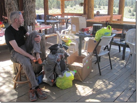
Having arrived at Kennedy Meadows by late morning, and not wanting to have a zero there, we immediately set about the chores. Within a quarter of an hour of arriving, and having picked up our parcels, we had stuff strewn everywhere on our little bit of the veranda (yep, all of the stuff on the table, chairs and floor to the right of Mick is our stuff, including our newly received bear canisters and a huge resupply parcel). Here Mick is looking at all of that stuff and wondering how in the world it is going to fit into our packs:
IMG_4433

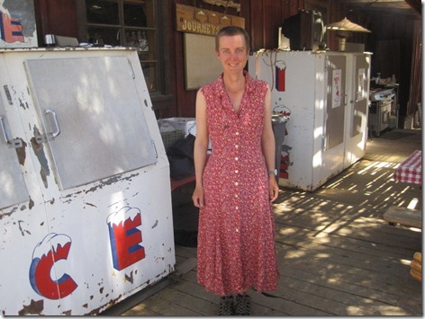
What can I say? Mick chose the frock for me and I spent the day in some sort of a 1990’s flashback! (Actually, for those who missed the explanation at the time, maybe I should also add that at Kennedy Meadows they have a cupboard of ‘loaner-clothes’ for you to wear whilst you’re doing laundry. With a shortage of men’s ‘bottoms’, Mick fetched me a frock so that he could use my shorts and not have to wear a dress himself):
IMG_4435

He also chose this shirt for himself. Behind him you can see someone else in an equally loud shirt. (That evening he made some derogatory comment to another chap about his ‘laundry shirt’, only to find that the chap wasn’t walking the trail and that the subject of Mick’s derision was his actual shirt. Oops!)

IMG_4436

With laundry done, bear canisters packed and other stuff either crammed into our bags or donated to the hiker boxes, we set left Kennedy Meadows on Day 16. Within a few hours, the surroundings suddenly changed and we were no longer in the desert. We had grass (green grass at that) underfoot here!

IMG_4459

This one doesn’t show how gorgeous the South Kern River was, nor does it show all of the swallow nests under the bridge (that photo didn’t make the cut). But it does demonstrate the usefulness of a bear canister as a seat! This was during the period when we were still having long lunch breaks and having our cooked meal at lunchtime. A week later, when we were struggling with slow progress, we decided that the temperature (and our ability to deal with the temperature) meant that we didn’t need to sit out the middle of the day anymore and we started having much shorter lunch breaks. Incidentally, this was the lunch break when, in 24 degree heat, I hat to put my fleece on, and thus realised that we had become accustomed to higher temperatures.

IMG_4467

The biggest tree ever? Certainly the biggest we’ve ever seen. It goes on for quite a way out of the top of the shot.

IMG_4477

I’m not a big fan of the campfire, and this was the only one we joined. It was one of the few days when we were camped with lots of other people around (going clockwise, starting with me, we have Strider, Shivers, BAM, Shepherd, Lil Steps and I wish I could remember who the chap was sitting next to me!)

IMG_4483

This became more prevalent as the walk went on, although often with detours and multiple blow-downs to deal with:

IMG_2392

I don’t recall exactly where this one is, but I recall taking it because of the size and quantity of the boulders scattered around. Mick being in the shot gives a good sense of the scale.

IMG_4499

A familiar sight – hills, forest and meadow.

IMG_4511

That’s Strider standing on the top of this rocky outcrop. Shepherd’s about half way up, just to the left. I didn’t want to watch for fear of an accident, but they both made it down safely. Youngsters, eh?

IMG_4516

Yep, more forest, hills and meadow. It was a view of which I didn’t tire.

IMG_2400

Cheeky chipmunk! You really had to watch these chaps. They had already tried to take the rubbish out of my rucksack pocket and the bags of food I’d left on the ground. Once the food was in the pot, this cheeky chap jumped on the top and was trying to remove the lid. I didn’t use zoom on this photo. I really was sitting about 2’ away at the time. Almost fearless in their pursuit of food.*

IMG_4537

Trees, jaggedy hills, rocky meadow. Gorgeous!

IMG_4549

Mick pauses to admire the view after a hard climb. At 11,500’ this was the highest point we’d reached on the trail up to that point, and it was the day on which I was absolutely exhausted. If it hadn’t been for the strength of my desire to get back down below 10,000’, I wouldn’t have made it through the next 7.5 miles (7.5 miles to go at approaching 5pm on a day on which I’d been knackered since 7am!)

IMG_4574

I have no recollection of this place! But, it’s certainly quite bouldery. Fear not: there’s no clambering required. In the construction of the trail, all rocks have been removed from its path.

IMG_2407

This is only about a mile before our campsite before Forester Pass, so must have been at around 11,000’. I hadn’t expected such greenness at such a height.

IMG_4589

Marmots are ten a penny in these parts, and are such lazy/laidback chaps when they’re sunning themselves on a rock that they’ll happily let you get quite close for a quick snap:

IMG_4594

It was a lovely river that ran past our campsite that night. Mick managed to sit here for as long as it took me to take this photo, before the mosquitoes chased us away from the water.

IMG_4599

That video snippet I posted the other day was on the approach to Forester Pass, and here’s a close-up of  the pass (look away now Colin if you don’t know where the path goes and don’t want a spoiler). The trail zig-zags up the head-wall to the right of the notch, then passes just under the notch near the top, before zigging and zagging a bit more on the left hand side to reach the top of the pass. It’s an incredible feat of path construction and my favourite bit of the whole section of the trail that we walked.

IMG_2419

That’s a steep bit of rock into which that path is constructed, but when you’re walking it the path feels much wider than it looks in this photo.

IMG_4635

Happy (albeit squinting into the sun) atop the pass. The highest point on the PCT, at 13,200’. We spent an hour up there drinking in the surroundings.

IMG_4639

The view to the north from Forester Pass. Down in that forest there was mud. We thought maybe the going was to become a bit less arid, but it was just localised dampness in that particular bit of valley.

IMG_4644

Part way down that valley we left the PCT temporarily to nip into Lone Pine for a well-earned bed and (more particularly) a shower (or four) and so ended Week 3.

(*As we sat waiting for the ferry to VVR a week later, the chipmunks were again eager for any food that may be available to them, even if it meant chewing through our bags to get it (of course, most food was in the chipmunk-proof bear canisters). As not everyone’s bag was close to them, the usual method of stopping them from chewing is to throw a pebble at them. “I can’t do that any more” said Hello Kitty, with whom we had been walking that morning. The story unfolded that, being the self-confessed ‘worst shot in the world’ he had thrown a stone in the general direction of a chipmunk which was after his bag. He was aghast as not only did he hit the little creature with some force, but it immediately keeled over, twitched a couple of times and then lay still. Yep, the worst shot in the world had killed an innocent chipmunk.)


Click here for ‘PCT in Photos: Week 4’