The Road goes ever on and on; Down from the door where it began;
Now far ahead the Road has gone; And I must follow, if I can;
Pursuing it with eager feet; Until it joins some larger way;
Where many paths and errands met; And whither then? I cannot say.

[JRR Tolkien, Lord of the Rings]

Tuesday, 13 May 2025

TGOC25 Day 5 - to NW end of Loch Katrine

(I've remembered that I can post to this blog via email (been years since I last did that!) So I don't have to fight with Blogger and hopefully a couple of photos will also have appeared)

Distance and ascent: 18km, 300m

Weather: another glorious hot day with just a few fluffy clouds.

I started my day with a phone call to the doctors' surgery; the response I received was both friendly and helpful and I was given an appt for 1045.

Check out at the hotel was at 1000, and the doctors' surgery was less than a mile away. So I got back into bed for an hour and sat writing blog posts, leaving the hotel at the last moment. 

Slowly strolling along the edge of Loch Long, I belatedly twigged that with a tide line of sea weed, this was a sea loch. Day 5 of my cross Scotland walk, and I'm still technically on the W coast!

The doctor was friendly and helpful too, and at 11am I left the surgery clutching a bag of antibiotics (it was about 2km later when I realised with horror that I'd not paid for them, before then remembering that prescriptions are free at the point of delivery in Scotland).

The next ferry across Loch Lomond was at 1145, and I had a 3.5km walk to get there. Doable, but I had a heavy pack full of supplies for the next four days, and I also needed time to buy a ticket. Not wanting to feel rushed, I decided not to even try for the earlier boat. Instead I took my time stopped for any number of faffs (and to buy my ticket online), after all of which I arrived at Tarbet just as the ferry pulled away from the pier.

My plan was to have something to eat in the café there, but it turns out the café is really a kiosk and they only sell sandwiches, plus a few cakes, none of which appealed.

So I sat on a bench, ate the food I had with me and even had to put my wind shirt on as, in the shade, the wind felt cool, rather than pleasantly cooling. 

An hour and a half later, I thought I'd go and buy myself a cup of tea before wandering down to the pier. First, however, I availed myself of the toilet facilities -and came out to find a queue of eight people waiting for drinks! Where'd they all come from?!

I abandoned hope of being served in time and went and got on my boat.

Half an hour later I alighted at Inversnaid and finally, at 1420, I was ready to start walking (because somehow the walk to the ferry from Arrochar didn't feel like part of the same walk).

A couple or three dozen WHW walkers (judging by appearances) were sitting outside the Inversnaid hotel, and more were encountered in the 100m or so that I followed the Way, before I turned off onto the Great Trossocks Path.

There's an Honesty Tea Room at Garrison Farm and on another day I wouldn't have hesitated to stop, but it being so late in the day, and having only just got started, I walked on by. As it went, I wouldn't have even gone past the farm had I paid attention to the map as the path there leaves the road to climb up behind the farm, only then to immediately descend almost back to the road. I would have just stayed on the tarmac for the tiny extra distance and cut across the field to gain the path, had I noticed.

Other than the pointless up and down, the path was rather pleasant and the surroundings were stunning, although I'm sure I've failed adequately to capture them in a photo.

Reaching the turn off the road for Loch Katerine, I discovered that the track that goes around its edge is a tarmacked private road. It goes past some stunningly located properties.

On reaching the shore of Loch Katrine I was almost opposite the point at which I wanted to leave it, less than 1.5km away as the crow flies, but 8k around the edge. Where's a chap in a fishing boat offering a lift when you want one?!

The walk along the road was quiet and uneventful except for the lack of water in the burns. When I finally found one with a trickle, albeit not looking particularly appetising, I filled my bottle, filtered and chemicalled it, then predictably the very next burn was flowing well and looked good. I couldn't be doing with repeating the process given the time of day, so made do with what I had. 

I didn't end up going all 8k around the loch. When I got to the NW point, where I was to turn back on myself down the far shore, there was such a good pitch on the riverside that I paused to give serious contemplation to stopping. I was 8k short of my intended destination, but it was gone 1730, meaning it would be late by the time I got to my intended night stop (the last 3k looked like they were going to be hard work).

Just then a chap in running gear appeared beside me, asking if I was lost. I didn't point out that I'd have to be the worst navigator in the world to not know where I was given all the visual clues around me, but reassured him that I knew where I was. He clearly didn't believe me and in the conversation that ensued he tried to direct me back onto the West Highland Way!! He also seemed rather dubious of my intended route and my statement of 'but I may just stay here and nip over that hill in the morning' (whilst pointing to the ridiculously steep side of Meall Mor).

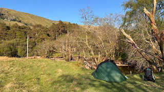
It was the enticement of Meall Mor* that finalised my decision. I popped the tent up on nice cropped grass, and spent much of the evening examining the hillside in front of me and the map, trying to decide on the route of least resistance. Based on what I could see (it's not just a steep hillside, but craggy too) I plotted three potential route variants on my map. Then, just before bed, I thought, why not just go straight up the burn in front of me? I could weave around on a slightly shallower line, but if that involved trogging through rough terrain, then maybe straight up, through the lack of intermediate contour lines, was the better choice?

Other than the passing chap, the only other passers by during the evening were a Waitrose delivery van (I was 5km from the nearest road!) and a fox that didn't seem to be at all afraid of my presence. 

(*I now realise in reading this back through that I didn't explain that I opted for my FWA (foul weather/feeling weary alternative) today. Not actually so much because of the loss of half a day, but because my planned route was another hard one, that I didn't feel inclined to do with such a heavy pack. I hesitated to put it in my route at all, knowing I'd be tired after the hills of the first few days, but as there was no guarantee that weather would have allowed me all of those initial hills, I included this day so as to give me the option. Meall Mor was included in that route, but approached and exited via the ridge, whereas I was now looking at going up one side and down the other.)


Monday, 12 May 2025

TGOC25 Day 4 - to Arrochar

Sunday 11 May

Distance and ascent: 23km & 900m

Weather: still glorious but with some periods of entirely welcome cloud cover. 


The downside of having gone to bed at 1930 (I was tired!) was being wide awake at 0330, and there was no option of an early start today as I very much needed to visit the shop at Lochgoilhead. I'd based my food supplies on previous backpacking trips, many of which have involved longer days and more ascent than this one. What I'd failed to take into account was that this one involved ascents with far more rough ground than I'm used to whilst carrying a heavy pack. It has become apparent that I didn't have enough food for the energy I was expending. 


Arriving at the shop it was a relief to find it open, but there then ensued a long and nervous wait when it transpired that their till system had fallen over and they couldn't process any transactions. Eventually the cashier asked if anyone was paying with cash, and I turned out to be the only person (of four customers) with any cash (unusual; I almost never carry cash in daily life). The till then locked up again and he couldn't even take cash. 


I was on the verge of suggesting I write down all the items and bar codes and give him an appropriate sum of money to process later, when the till was resurrected. I went outside with my wares and immediately ripped onto the fruit cake like a wild animal. Passers-by stared. I cared not a jot. 


Suitably revived, onwards I went. I'd found at the end of yesterday that the Cowal Way on the ground didn't match the map and the same happened again today. Yesterday's alterations had been a detriment (using tracks rather than paths) this morning's was a good one, following a new coast path rather than the road. 


Out the other side of Lochgoilhead, I was to climb consistently for 760m. The CW only goes up to 500m, but I wasn't going to bypass this morning's hill - the Corbett of Cnoc Coinnich.


What a refreshingly easy hill that was! It got promoted to Corbett status in 2016, and thus has now seen nearly 10 years of relative popularity. As a result, a trodden line has formed. I was up in 30 mins and down in 12, having left my pack just above the track junction. Having eaten half my lunch at 11am, before visiting the summit, I finished it when I got down and decided I ought to have bought two pasties, not just the one. 


I'd not then got far to go. Something like 12k, largely downhill, mainly on good paths and tracks. 


My timing was perfect. I arrived at the Loch Long Hotel at just gone ten to three, with 3pm being the earliest check-in time. I filled the time by making my Phone-in to Challenge Control.


It would be an understatement to say that the Loch Long Hotel has seen better days. They gave me a room on the fourth floor and the lift was out of order, but I had no complaints. It would be quiet up there (there are only seven rooms and a panoramic view lounge on the top floor), and having paid just £40 for single occupancy of a double room, and having held a parcel for me, they could put me wherever they wanted!


The room wasn't bad, if you can overlook small cleaning issues, the lack of a plug in the sink (or strainer arrangement -anything dropped would go straight down the drain), and the lack of a lever on the shower (despite a clear instruction on the bathroom door telling me to operate the shower by pulling the lever towards me). I found easy solutions to the issues and soon had electronics charging and laundry drying. 


Tea, from the chippy across the road and eaten on a bench overlooking the loch, was disappointing but filling.


So that's what went on from a walking/progress point of view today, but there was also a side issue. 


Two and a half years ago I suffered from cellulitis on the bridge of my nose. Not knowing what it was and hoping it would go away of its own accord, I ignored it for 9 days until I felt like I'd been punched in the face and couldn't take a step without it hurting. I called the doctors' who considered my symptoms to be an emergency and saw me straight away. I left with antibiotics and an instruction that if I got any worse I was to go straight to A&E. A bit dramatic, I thought, but apparently there's a risk of infection spreading to the brain and sepsis occurring. So, when yesterday I'd felt the same first signs, and by the start of today it had progressed to 'this is definitely the same thing happening again' my first reaction was that my Challenge was over. Disappointing, as to have the opportunity to cross Scotland in this weather is incredible.


Then I put some more rational thought into it, decided that I had time on my side and that this was purely a problem that needed solving. 


I was pretty sure, from previous experience, that heading into the hills for four more days, hoping the infection would resolve itself, wasn't the right solution, but by the end of the day I had three possible plans:

  1. worst case - train to Montrose, use medical centre there, take advantage of being able to ditch some kit, train back.
  2. Most likely - a day-trip by train to Alexandria (as far as I could make out, the nearest pharmacy and surely a doctor nearby).
  3. The local GP - worth a try, although I didn't fancy my chances of getting an appointment. 

There was also the hope that it would be improving by morning in which case maybe it wouldn't be too reckless to continue across Loch Lomond and take my FWA, which would see me at another main road within 1.5 days, if needed. 


(I feel a bit bad leaving this on a cliff hanger, so I'll just say that I have drugs and the ferry across Loch Lomond is just about to depart, with me on it, and only half a day has been lost)


Red = plotted line as walked; blue = recorded once I remembered to start my watch!


TGOC25 Day 3 - to Curra Lochain/Lettermay Burn

Saturday 10 May

Distance and ascent: 23.5km 950m

Weather: mainly sunny with the occasional welcome fluffy cloud. 


I shall save myself some typing by reproducing my morning messages to Mick:


Rather too eventful a night here. Woke up at 2315 with: a) a migraine (yesterday's oestrogen patch has fallen off my arm); and b) the tent being bashed by the wind. Lay here a while thinking I should go out and check the pegs and tension, what with being pitched on a bog. Eventually stirred myself to get dressed and go out. Somehow managed to slice my finger on way out of tent and next time I looked at my hand it was covered in blood! A bit of mopping up and a plaster sorted it. Wind continued thrashing for another 20 mins or so, then abated.


Current plan (0550) is to go up Beinn Mhor this morning, omit my second hill and go up the evening excursion one. The middle one is the easiest to get on a revisit. May yet opt against Beinn Mhor (I have others unbagged nearby, but I am only 400m below summit here, so it makes sense to do it).


0610: revised decision- not going up Beinn Mhor. Feeling quite poorly. Eating breakfast was a struggle. Easy day, and hope the new patch sticks and absorbs quickly.


0735: You'll be unsurprised to know I'm on my way up Beinn Mhor. May as well do something whilst waiting for tent to dry.


.........

Morning excursion up Beinn Mhor
 

It had been a hard, slow climb up (initially navigating via a photo I'd taken the previous night from across the glen, and making use of an old, now largely grown over with reeds, logging track) and a much faster descent. I think it was about 1030 by the time I was down and had the (by then perfectly dry) tent packed away and was ready to go. Having done what was supposed to be the morning's first hill last night, I was now effectively taking my FWA, straight down Bernice Glen. 


That was a bit trickier than expected, especially at the bottom where natural woodland is sprouting up across the entrance to the glen. I had to hunt around a bit to find a way through the trees to the start of the track I was to take, and on my way I managed to kick a small boulder with my left foot causing it to roll into my right ankle. Oh the pain!


There was swearing. It wouldn't immediately bear weight. But I also knew that it was only going to be bruised, not actually injured, so I gave it a couple of minutes then limped on. Like a premiership footballer who has been writhing around on the floor, within a dozen paces the pain had been forgotten (only remembered at the end of Sunday when I caught sight of the bruise).


The Cowal Peninsula was hit hard by a winter storm in 2023, closing various trails on the N side of the woodland I was now entering. I didn't know what the status was on the S side, but was soon to find out. I don't think 'impressive' is quite the right word, but the force of nature was soon clear to see and I could only imagine what it would have been like to witness the storm destroying parts of the forest and its tracks. Aside from deeply washed out sections of track (in one case going on for hundreds of metres) there were places where landslips had clearly transported trees, still upright, from above the track, to on the track. Those trees have now all been felled, so I'd be walking along and suddenly there'd be a mound across the path, covered in relatively freshly cut stumps. All were perfectly passable, so it was a surprise to find a sign at the Glenbranter end of the track telling me that it was closed. 


Glenbranter visitor centre is now permanently closed, but they still have toilets, picnic benches and a drinking water tap. I was happy to avail myself of all of those facilities, although I opted for a bench in the shade of the building rather than a picnic one on the grass.


I may have even had a cheeky wash of my hair, using the sink in the toilets. Cold water only but on another hot day it was all I wanted or needed. 


I'd not long emerged from my hair wash when another backpacker appeared who turned out to be a Challenger, Kevin. He'd started a day after me and was now overtaking me. 


He left first whilst I faffed and enjoyed the shade a while longer. 


I'd not long left the Visitor Centre when I was slightly outraged that the Cowal Way followed a fast A road with no pavement. Then I looked at the map and realised I'd left the CW again. I wasn't on the road for long before I turned off towards the hill I'd decided not to do. Going past it was still of value as I got a good look, from various vantage points, of the various ways up through gaps in the forest, which has changed my mind about how to will approach it when I return. 


The track I was on was relentlessly uphill to a pass and on my way I passed probably about a dozen walkers all spread out. I didn't ask any of them whether they were on a day walk or doing the Cowal Way.


Just before the Bealach, I passed a perfect camping pitch. To stop or to go on? I have a loose rule that if I see a good pitch within the last hour of the day then I should take it. I didn't take it, although only because I wanted to keep my options open for an evening excursion up Beinn Lochain.


Just before Curra Lochan, I filled my water bottles from a nice side burn, coming down from Beinn Lochain, in preparation to camp by the lochan. Alas, closer to it became apparent that the nice green patch that looked promising from a distance wasn't viable. So, I paused to put the water bottles into my bag, and having not seen anyone for hours, I didn't perceive a risk of not bothering to step more than 3 paces off the path for a wee. Cue Kevin suddenly appearing over the rise behind me. I don't know - I see one Challenger in 3 days and he catches me with my trousers down!


After working out how I'd got ahead of him (I'd short cut the Cowal Way; he'd followed it), he went on ahead. 


I then faffed around trying to find a pitch. The longest detour I took was about five minutes each way to a likely looking spot on the far side of the loch, but again when I got there looks had been deceptive. 


On reflection, there may have been a spot by the out flow, but there were three chaps in and out of the water and they were occupying it so I didn't explore it's potential. My evening hill was thus firmly off the agenda and I put my hope in something next to Lettermay Burn.


When I got to the furthest point I was prepared to go (didn't want to get too close to civilisation on a sunny Saturday night, not that Lochgoilhead is a heaving metropolis) it became a case of choosing the least bad ground I could. Not the best pitch ever, but far from the worst.


That it was in the shade of trees was a bonus. That it lost the sun completely (behind the hill I hadn't gone up) at just gone 5.30pm, less so. It cooled down quickly.


Sunday, 11 May 2025

TGOC25 day two: to Bealach Bernice Glen

This is another dictated post please excuse errors and lack of quality. Photos will follow in a few weeks. 


Friday, 9 May

Distance and ascent: 22km, 1200m

Weather: mainly sunny with just a few fluffy clouds in the afternoon


Another morning that required the midge head net.


When I was scouting around for a pitch last night I considered climbing about 50m up the hill to where it looked like the land flattened out, but not wanting to do that only to find there wasn’t anywhere suitable, I stuck with the not-the-worst-ever pitch at the track end (actually it turned out to be perfectly comfortable). I soon discovered this morning that I should’ve continued upwards, with plenty of opportunity for a good pitch in various places up there.


A good, unerring trodden line took me from the end of the track, near to which I'd camped (at 150m), up to about 350m. Beyond there, other trods and ATV tracks made the going easier than expected and there was relatively little yomping.


After visiting the summit of Cruach nan Cuilean (432m) my vetted route had seen me descend E, almost back down to sea level, before climbing the other side of the glen to a forest track. It was a late change when I saw that if I headed north off the hill, I could probably cut through a bit of forest and that way I wouldn’t drop below 250m. It would also cut off a little bit of distance. It was pleasing from the top of the hill to see that the forest had been felled and thus even from a distance I knew my new route would be feasible. I stopped for water on the way which turned into quite a long break.


After dropping down to a burn and then climbing up the other side I just had to climb over a bit of clear-felling detritus to get onto a forest machinery track (not a made track, just the one formed by the passage of the felling machines). I would’ve appreciated if they’ve left a little bit less detritus on the track but I suppose they were working for their own convenience not for the single walker who might have thought this was a good route! Even so, it worked well and got me to the forest track I wanted to be on.


My intended route out of that section of forest was the same on both my original and my revised route, but when I got there it was blocked. Fortunately I had a fallback, which turned out to be the most perfect fire break I’ve ever walked: firm under foot, only the most minor tussocks, no bog, no blow downs.


My second hill of the day was Creag Tharsuinn (643m) which involved about 3km of rough, tough terrain, but I took it steady and slowly made it to the top. I had lunch on the way on the most perfect chair shaped rock. It was only after I had eaten that I thought to dry the tent so I paused longer whilst a bit of the moisture evaporated.


My original route had again seen me dropping very steeply east off this hill, down to cross the 150m contour, before climbing steeply up to the 741m summit of Beinn Mhor. I’d again noticed that I could save dropping some height by going a slightly different way, with the bonus that it meant I could pitch the tent and then do another packless out-and-back - I didn't have it in me to climb another pathless 600m. However, the revised route did again rely on fire breaks being passable and given the destruction all around from winter storms and that I’d already been lucky once today, I knew I was taking a risk. 


Had I known that the bottom of that glen there was an old, unmapped track, I would’ve dropped down from the Bealach before Creag Tharsuinn (after doing a packless out and back up to the summit). As it was, I continued along with the slightly undulating ridge beyond the summit and then dropped very steeply down between crags only to find that my intended way on through the forest was blocked. I had little confidence in my fallback, but was lucky again. I joined the lovely old track and although I was braced to find a mess of fallen trees at every turn, it had only one small blowdown which I just stepped over.


Once I joined the modern forest track, I climbed up to Bealach Bernice Glen where I struggled to find a good pitch. In fact there was no good pitch. After poking around some distance in various directions, I pitched the tent on a bog, went to get water, scouted again around the burn (which was about 200m away from where I'd pitched) then went back to the tent. Belatedly I saw what looked like an old track up above the burn so I trogged back over there and clambered up, hoping that there'd be a grassed over area at the end where I could move to, but no. I was to be a bog dweller that night (again, it turned out to be a perfectly comfortable night).


Back at the tent I couldn’t face another hill today and it was too hot to sit in the tent so I made an early tea found a rock outside to sit on ... then decided actually I could face another hill but instead of the one that I intended to do today, I brought forward tomorrow's smaller hill (Beinn Bheag 618m), on the opposite side of the pass. I was supposed to do that one as a traverse with my pack, but was happy to take the easier option. 


Before I set out, I plotted a route to minimise distance and avoid lumps in the way. I then proceeded to ignored my plotted line and went up the hard way after all. I came back on the plotted route which was much more sensible and efficient. On my way down, I crossed a track that wasn’t on the map. I assumed it wouldn’t be any use to me but it did go my way and I ended up tracking it, but I was slightly higher up the hillside, uncomfortably contouring rather than using it's nice flat surface!


Back at the tent, I was feeling what a long hard day it had been (effort over that terrain, rather than distance) and thus I declared it to be bedtime. 


(I appreciate that all the directional notes and old vs new route will make much more sense once I've added a map snippet in, in a couple of weeks' time.)


First part of day. Blue route is as recorded. Red route is as planned.  
Second part of day (blue = recorded; red = planned; purple = evening excursion up Beinn Bheag)