Soooo many photos from the days on the HRP. It was definitely the highlight of the trip and I would recommend it as an alternative route to anyone. Aside from the aesthetic attractions, and it being 10 miles shorter and 1200m of ascent less than the GR10 route (slow going, mind, due to the terrain), we later encountered two other GR10ers who absolutely cursed the Gabas-to-Grouette section which we omitted by having taken this route. I’ll try to keep the narrative (relatively) short as I’ve included so many piccies from these three days:
Day 11:
Refreshed (or not) from our 3.5 hours sleep, off we set to go over the col to the south of the Pic du Midi d’Ossau, which, as you might expect, gave us some excellent, close-up views of this impressive peak:

The boulder field on the way up housed a family of marmots, giving me my first opportunity of the trip to say “There’s a marmot over there!” (for completely uninteresting reasons which date back to the PTC, it has to be said in a certain tone of voice). The fella in this snap posed nicely for us:

Food was an issue on this leg as we had knowingly undersupplied on the basis that we could eat in some refuges as we went along. That was all very well in theory, but did depend on hitting the refuges at an appropriate time of day. Fortunately, at Refuge Pombie they recognised that I was so hungry that any passing scabby dog was in danger, so they whipped up this spag bol for us at 11am. Unfortunately, the angle from which I took the snap doesn’t show quite how much food there was:

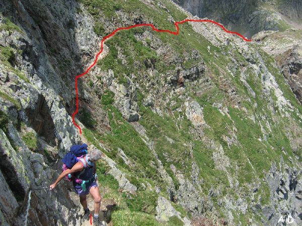
It fuelled us nicely for a big descent followed by a big ascent, followed by a bit of faffing around deciding whether to take the Passage d’Orteig or not. It’s not the most flattering photo of Mick, but if you look really, really closely you can pick out the wire going off into the distance:

There were no photos from further along this section as there was no way I was getting the camera out when my hands could be better employed by holding on! What we couldn’t see, in the conditions, was how big a drop there was to our left (in fact, I didn’t even take a single glance left on the whole of the time we were on this section). So, I got home and Googled to see what we’d missed; this next photo lifted from Google Images confirmed that I wouldn’t have liked to have done the passage in good weather! (As it went, I forfeited any right to complain about what we were doing when it was me who insisted we went this way; I couldn’t face another 1000’ of climbing, which is what would have been involved if we’d gone the other way):
When we got to the dam I knew that we were within a couple of minutes of the refuge which marked the end of our day but began to wonder if we would walk slap into the building before we saw it:

During a brief clearing of the murk during the late evening, I took the opportunity to take a quick snap of the location where we had ended up, but it didn’t open up enough for us to even see the lake adjacent to which we were pitched:

Day 12:
It was all rather different in the morning, when the cloud had gone! That grey thing across the bottom right of the photo is the tent fly-sheet. Yep, this was another photo taken from the comfort of my bed:

The view back over the refuge to the slope we had descended in the murk wasn’t too shoddy either:

After the drama of Jerry’s nose, a sedate walk along a lake, under a perfect blue sky was called for:

Then a walk above another lake, again under a perfect sky, along an engineered trackway:

Then we had to go for a bit of a trot, as Mick spotted that if we weren’t careful we were going to get stuck behind a large group of backpacking youngsters. Look carefully at this pic and you’ll see them stretching all the way from the bottom right corner, to the just above the centre of the snap. That’s a lot of people!

Now, how did this little bridge get damaged like that?

I think this next one illustrates quite well why the going was so slow over Days 11 and 12. The mileage for the two days added up to just 21 miles with just under 2500m of ascent, but because it wasn’t ‘stride out’ terrain, we were moving for approximately 15.5 hours to cover that distance.

This high lake, just before Col de la Fache, was still quite snowy…

…as was the steep scree slope we had to cross above it. In fact, it was the most significant snow we had to cross, although for us it was no problem as, being mid-afternoon, it was nice and soft:

There were some much bigger snow-fields later on, but they were horizontal, so no steep slide into a lake would have resulted from a slip here. These were the ones we walked across as slowly as we could, in an effort to cool down the over-heated feet (all those rocky paths do act as heat-stores on a hot day!):

Hmmm. No idea why I included this one, other than because it’s quite pretty:

Just above and to the right of Mick’s hat in this snap is Refuge Wallon, along the valley. We were really quite close, as the crow flies. Alas, as a touch of cruelty at the end of the day, the path wends its way down the hillside to Mick’s right, doubling right back to cross a bridge on the far right of the snap, before finally heading to the Refuge:

Day 12:
The Aire de Bivouac at Refuge Wallon is huge, but the riverbank is obviously the popular place, as we had plenty of neighbours that night (none of the three tents behind us was there when we pitched):

I hadn’t expected much from the walk down to Cauterets, so I was very pleasantly surprised by how picturesque it was. Someone we met later was rather uncomplimentary of their walk into the town, which I couldn’t initially understand, until I remembered that the way we’d walked in wasn’t the Cicerone GR10 route (as it goes, part of our route was on the GR10, but on a variant not used by the Cicerone guide):


So, all quite lovely, really


I'm getting the impression that, despite much loveliness and maybe some nice food, the GR10 just wouldn't be for me. Not sure why...
ReplyDeleteAre you being a tiny bit put off by the Passage d'Orteig? Think I might have been if I'd seen it in advance!
DeleteThose are really wowsome photos!
ReplyDeleteIt was rather nice around that area.
DeleteAmazing scenery and weather. All those kids! Were they doing the GR10 too? Geology reminds me of the Picos and brought back good memories.
ReplyDeleteThe kids were actually on the GR11 (this was during our little jaunt into Spain), and when we left the that path to continue along the HRP they continued along it. However, I suspect that they were actually just out for an overnight trip, around the lake.
Delete