
The Aire at Lanestosa
When Mick visited Lanestosa's Tourist Office on Saturday, he was advised against the route marked in yellow in the village's walks leaflet, on the basis that it is not well waymarked. Today we thought we'd go and see whether 'not well waymarked' meant 'abandoned and impossible to follow'.

Looking down on the village not long after we started heading up the hill
Following what appeared to be a very old, but well constructed trackway as it zigzagged up the hill, we learnt that there was absolutely no waymarking at all, but that the route was perfectly followable when armed with the route downloaded onto an electronic map.
It's clear that at some point the old trackway had become very overgrown, as there are still the remains of tree stumps along its line. Not only has it been cleared, but a good chunk had also been recently strimmed.
Then, suddenly, the strimming stopped.
"Do you think we missed a turn?" I said to Mick and once we had dismissed that idea, I joked that the man they had sent to do the strimming had returned to the town hall to ask if they really wanted him to continue his efforts, as no-one ever goes that way anyway.
A few moments later the now-overgrown track suddenly dead-ended on a steep, ungrazed hillside. There was, however, a hint of a line to follow* in that grass and it led us, by and by, to a bit of the barbed wire fence where the bottom strand had been hooked up to the one above it. We duly crawled under, noting that we were still exactly on the line of the route I had downloaded.

Photos never truly represent how steep a hillside is. Falling on some bits of this would be ...unfortunate.
Reaching the top, it felt a bit like Marilyn bagging can be - the highpoint was just a limestone outcrop in a field of cattle. We were barely any higher than the road that joined a few farms up on this ridge.

Mick strides towards the top
As unsatisfactory as the top was, it did afford us a view of the hill we went up on Sunday that made it look far more dramatic than it had felt when we had been on it...
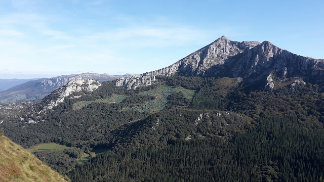
...and the outlook in the other direction wasn't too shoddy either:

Elevenses was had on the top, watching a bull, about 100m away, that was watching us. We didn't feel unduly threatened, feeling sure he wouldn't be inclined to charge over the limestone pavement where we were perched.
Looking ahead to where the lollipop route was to take us next, a return along our outward route (the one where I had exclaimed "I'm glad we haven't got to come back this way" in respect of the steep ungrazed bit) came to look the more appealing option. Thus, retrace our steps we did - or as close as we could. It took us a while to find the right line across that steep bit, and we came out the other side thoroughly prickled having waded through gorse and done battle with brambles.
It was thus pleasing to regain the strimmed track, whereupon we immediately spotted the turn we had missed on our outward leg. Exactly where we thought the strimming stopped, there was a switchback, where the cropped grass continued. We can only assume we were distracted with the view across the valley as we strode on past it - and perhaps we should have just backtracked a few paces when I'd said "Do you think we missed a turn", but we weren't helped by (once again) the person who had recorded the gpx track having done exactly the same as us.
Back at Bertie, the outing had come in at 4.7 miles with 1300' of up and whilst it wasn't offensive, neither of us classed it as a good walk. It wasn't a patch on the one we had done on the other side of the valley. It's just a pity we didn't have today's weather for that one. As you may have noticed, today we were blessed with a perfect sky.
(*I wonder how many people have downloaded the same gpx file as I had, and thus have helped wear that same vague line through the long grass on that steep hillside, crawling under the same bit of barbed wire fence, because in the absence of waymarking, they only had the gpx route to go on, with no way of knowing that the person who recorded and posted it had gone awry.)


Your overgrown path reminded me of a section on the SWCP in summer 2016:
ReplyDelete"I forgot to mention a couple of days ago a section of the path about a mile and half long was irritatingly overgrown - it was the National Trust again who ought to stick to looking after properties instead of fighting a loosing battle with nature and chopping trees down all over the place. A notice proclaimed the area to be suited to glowworms, yes glowworms, and good old NT didn't want to upset them by strimming the path."
Our overgrown path would have been a lot less overgrown if we'd actually been on the right path!
DeleteSome of the paths I walk at home are only passable in deep mid winter, when things have died back a bit. At least we've not encountered anything that bad here yet.
Did you edit the OSM with the correct route? I use the "Go Map!" app on the iPhone :-)
ReplyDeleteThis was the first time in the trip that I downloaded some 1:25k map sections, rather than just using Open Cycle Map. I did that for the ease of offline use, and for the extra detail, but did note that there are far fewer tracks and paths marked on the 1:25k than there are on Open Cycle Map. As it goes, none of these paths were on OSM either. I'll have to look into editing - it sounds complicated!
Delete