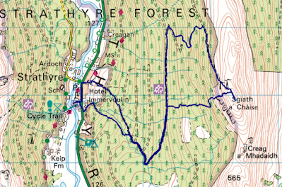
My route. There was no need to go such a long way around to reach the forest track (see Mick’s route below).
Mick’s route – same outward route as me, but taking a longer route from summit to upper forest road, then shorter way from lower forest road to car park.
I gave Mick the choice as to whether he wanted to do the Corbett or the Marilyn with me this morning and to my surprise he opted for the latter. Happily, he didn’t show any interest in doing both, which is what allowed me to do the linear route.
Other than taking a slightly longer route than necessary at the beginning, our progress to the upper forest road was uneventful. I had read reports as to the best way to get from the upper forest road to the summit, but on our way to the track junction at NN573179, we came across this new track at NN 57357 16812:
An engineered track, although a rough, low-quality one.
We couldn’t see how far it extended, but decided it was worth a punt that it would take us either to the top of the forest, or near enough as to make any subsequent bashing worthwhile compared with the much longer route I’d intended to take when we set out (the route Mick took on the way back – see map snippets above).
There’s more than one new track up here…
…complete with new bridges
It was steep in places, but steep on a track is relatively painless (versus, say, through knee-high tussocks), and our decision to go that way was borne out as we got higher, crested a rise, and could see that the track did indeed continue.
It came to an end at NN 57967 16922, just before we got out of the forest, but there was only one slightly dodgy manoeuvre required on our chosen line up the edge of the unharvested area, then up between two crags. The downside of this route was that it didn’t conveniently land us at a gate in the deer fence.
Summit selfie
Mick came with me a short distance beyond the summit, so that he could see where I was going next, then once I’d rummaged around in my bag for my waterproof (for warmth, although a shower was seen approaching; it turned out to be hail/snow), Mick turned back and I continued on.
The descent was steep but doable, and at the bottom I had a choice: to continue down the glen for 750m to pick up the baggers’ path to the Corbett of Beinn Each, or to just attack the hillside ahead of me. I could see what looked like a good line ahead, so opted not to do the longer distance. Looking at the map again now, had I been making that decision based on the map alone (e.g. in poorer visibility, without being able to see what lay ahead) I wouldn’t have gone that way, as I have a general rule that if there are only two intermediate contour lines shown between the 50m contours for more than 100m, then it’s too steep. As it went, the terrain was firm, cropped grass so whilst steep, the going was easy. I intercepted the baggers’ path at an altitude of around 570m.
By 700m I couldn’t help but notice not just the strength of the wind, but also the chill that it bore. Pausing to send Mick a message once my phone signal returned, I estimated the windchill to be around -10. I later looked up the MWIS forecast, and that’s exactly what it predicted. Whilst it was only my hands that got cold (or never warmed up; they were cold when we set out), even with the steep ascents, the first time I felt truly warm on this outing was when I descended back below the 300m contour (I had on a long-sleeved baselayer, a windshirt and my waterproof, plus a buff and buffalo mitts).
Another summit selfie
There was clearly another Marilyn over there (Munro too, as it turned out when I looked at the map later), but I wasn’t in a position to nip over to it today.
As I left the summit I messaged* Mick with an ETA of 1255 at the layby where he was meeting me. I arrived at 1256, which wasn’t bad, I thought, considering I’d taken a small accidental detour in the final kilometre (missed a turn) and then encountered a few blow-downs across the path.
An excellent morning out and encouraging that I felt good the whole time.
(*I discovered yesterday that my phone has lost the ability to make phone calls. It occurred to me today that could be a problem should I find myself in a pickle. It’s still letting me text and WhatsApp.)


No comments:
Post a Comment