The Road goes ever on and on; Down from the door where it began;
Now far ahead the Road has gone; And I must follow, if I can;
Pursuing it with eager feet; Until it joins some larger way;
Where many paths and errands met; And whither then? I cannot say.

[JRR Tolkien, Lord of the Rings]

Saturday, 6 February 2010

On Wednesday Last: Around Ogden Water

Late on Tuesday evening I took it into my head that we should pop up to the Lakes for a couple of days. Half an hour later, having perused various sources of weather information I concluded that Wednesday wasn’t looking like the best time to be on a Lakeland hill-top. Thursday was looking much better with MWIS’s assessment showing a 90% chance of cloud free summits in the morning. The trip was modified such that we would pop up to Ma-in-Law’s on Wednesday and take a short stroll up there, and then head up to the Lakes on Thursday.

With such a lack of prior planning, and with the need to round-up a suitable selection of camping and walking gear, we didn’t manage the earliest getaway on Wednesday morning and so we didn’t arrive at Ma-in-Law’s until noon. Aside from it appearing rude to say ‘Hello, lovely to see you, we’re off out for a walk’ as soon as we walked through the door, there was a hunger issue to deal with, but as soon as we had had lunch (and drunk three mugs of tea apiece; Ma-in-Law doesn’t skimp on providing welcome cups of tea!) out we headed.

Once again, it was rather a late start, so we opted for our usual choice of Ogden Reservoir for a short stroll.

The water was more-frozen-than-not (which is not overly evident from the photo below) as we walked down to, and across the dam, in order to take the cobbled track which would take us up on to t’moors.

IMG_0501

More frozen water was to be found on that track, however. From side to side and entire its entire length it was solid.

Admittedly, it was easily bypassed by taking to the grass at either side, but what was the fun of that when we had unused Kahtoola Microspikes in our packs?

 Grinning like a loon with car-chains-for-feetIMG_0504

They did their job well (at least they did when I had both of them on the right way, with the spikes facing downwards <blush!>), and within moments Mick was getting jealous of my ability to walk on (frozen) water and was diving into his pack to put his own pair to good use.

 Red jelly-feet all aroundIMG_0505

They’re working for Mick too 

IMG_0506

We did feel a little bit daft when, grinning from ear to ear, we stomped our way up the middle of the ice, straight past two chaps walking far more appropriately on the grass to the side, but we were having massive fun, and that’s what counts.

The ice subsided as we got up onto t’moor and so off came the spikes (confirming to me that they really are easy to both don and remove even with hands in mittens), but there was still a mixture of new snow, old snow and ice:

IMG_0513Mick took many snaps of the patterns in the ice up here, but the photos don’t do them justice. More successful was the photos of the ice (formed on individual blades of long grass) on the sluice gate under a bridge as we crossed as we left t’moors for the path back down to Ogden water.

IMG_0515 The path down the stream was even prettier than it usually is, with the beneficial addition of snow:

IMG_0518IMG_0519Then it started snowing (exactly as forecast). By the time we got back down to the reservoir the iced surface was getting whiter, but that didn’t put us off taking the longer route back to the car park by circling the lake first. The following snowy shot is more or less from the same position as the first photo above, taken an hour and a half later:IMG_0522

IMG_0521Again it was a short outing (with just over 4 miles covered with a nose-bleed-inducing 800 feet of ascent), but it scored abnormally highly on the ‘fun per mile’ ratio.


On Monday Last: A Stroll In The Woods

On Monday evening I found myself scrutinising every single square of our local 1:25k map. The scrutiny eventually revealed that there are only two trig points marked on that sheet, but it took me a long time to establish that because I kept getting distracted by areas of woodland and footpaths that I had not before noticed, which led to consideration as to whether they would yield a good route for one of our local walks.

One of those areas is just four miles from us, and having also established that the woodland in question houses five Geocaches, I decreed that on Tuesday we would take a stroll there.

Tuesday dawned wet and continued that way for quite a few hours. The rain did finally move on to pastures new, but we mastered the art of procrastination and thus it wasn’t until the remaining daylight was running out that we finally jumped in the car for the short drive to our chosen spot.

Within a minute of setting out the rain started again and we kicked ourselves for missing the window of dryness. We were not deterred (not even when I realised that I had left my hat at home; nor when we got half way down a lane to find that the ‘road closed’ sign wasn’t a lie), and onwards to our chosen woodland we went.

A bit of a meal was made of finding the first Geocache. I’d made it more difficult by not having marked them on the map, nor having picked up the piece of paper on which I had scrawled the details, compounded by the tree cover preventing the GPS (in which I had programmed the grid references) from being able to find enough satellites.

Eventually the GPS did play ball, and after a bit of pacing back and forth, following by a bit of beating through undergrowth we did find the first cache, only then to find that it didn’t have a pen, and neither did we.

Walking along the edge of the woodland whilst justifying my status as ‘fashion leader’ by wearing red over-mitts, orange jacket and a bright pink buff on my head.

IMG_0499 We made nearly as much of a meal of finding the second cache, but that was a meal within a small area as we just couldn’t locate it when we got there. Once found, the pencil was liberated to use in the next two, with the intention of returning it on our return.

As I puffed my way up a short incline, I was coming to the conclusion that this was not the prettiest woodland in the world, and even the pond that we reached a few moments later did not have a lot to recommend it. Maybe it’s all prettier in summer?

IMG_0500 Cache number three contained two pens, so, adding to our collection, we took one of them so that we could complete a proper redistribution of writing implements, even though that now meant that we needed to revisit both of the first two caches.

By number four the rain was getting a little tiresome, but by good fortune it let up a few moments later, as we formed a loop to take us back to the pond and thence back to caches two and one.

The fifth cache eluded us. It was a puzzle one, and having found the required four digits from the first four caches, I found that I didn’t know what to do with them. Further investigation upon getting home told me that I should have noted a grid reference of which certain digits were missing. As it goes, even if I had noted it, it would have been on the bit of paper I’d forgotten to pick up!

The walk turned out to be tiny, at a smidge over 2.5 miles, but it was one of those days when it was looking like we weren’t going to get out at all, and surely 2.5 miles is better than none? Plus, we sampled a new area, even if it didn’t make it onto my list of places to which we must return.

Friday, 5 February 2010

Woods and Stuff

It’s been a varied week.

On Tuesday we went for a walk in some local woods (but not our usual local woods).

On Wednesday we went for a walk in some woods that were not at all local, but with which we are quite familiar.

On Thursday the visibility was so bad for most of the day that, for all we could see, we may well have been in some woods.

Over the weekend I will look through the resulting photos and string together a few words.

IMG_0544a

Thursday, 4 February 2010

And as I typed...

30 seconds after taking the photo on that last post, the murk lifted a bit.
Sent using BlackBerry® from Orange

At Stickle Tarn

Bit murky up here, and someone seems to have stolen the tarn and replaced it with an ice rink.
Sent using BlackBerry® from Orange

Monday, 1 February 2010

In Trentham Gardens

Following Jeff coming to join us for a jaunt on the Chase a couple of weeks ago, today we went to join him on his local stomping ground, at Trentham.

We were ignorant of the route that we were going to take, with Jeff being our guide, and the first thing we did was to get our heart rates up by walking up to the monument on the lump above the car park.

IMG_0488The climb may not have been long, but it was steep enough to get me huffing and puffing, all of which I blamed on the pack on my back, rather than on the truth of a general lack of fitness.

Fortunately there was opportunity to catch my breath whilst up at the monument, as there were views to be taken in and an information sign about the monument to peruse.

IMG_0489Within moments of setting out three large deer were spotted, but as we continued onwards and skirted the Monkey Forest there were no monkeys to be seen. As the temperature when we left home had been just under –6 degrees, if the monkeys had any sense they would all have been huddled up somewhere for warmth, so it was no real surprise to not see them swinging through the trees.

Another short ascent took us up some steps which were built for people with 6’ long legs (or maybe the ground has just eroded since they were built; either way it was hard work for my little legs!), and we slip-slid our way along the ice, skirting the top edge of the woodland, with the sight and sound of the M6 to our left.

A quick detour was made for a geocache that was but a few yards off our path, which from the look of this photo bemused Jeff:

IMG_0494 We slip-slid our way along more ice to a bridge over the motorway, which the Trentham Estate has blocked off with vicious, tall palings. That’s a shame, as although it’s not a right of way, it has prevented execution of any number of circular walks that would take in both Trentham Gardens and Swynnerton Old Park on the other side of the M6.

More slip-sliding took us down to Trentham Park, where we encountered a couple walking a dog (who tripled the number of people we had seen to that point), paused for some brownie that I made last night (to Martin’s recipe), and then onwards to make our way to the main entrance of Trentham Gardens.

Once through the shopping village and into the Gardens (for which a charge applies; thanks go to Jeff for procuring tickets for us before we even arrived), it seemed like time to refresh ourselves with a cup of tea, so the cafe was sampled, although not before we had been and taken a look at the deserted ice-rink, which is on site for another 3 weeks yet.

The cafe felt superheated after the temperature outside, but the views from the windows were far from shoddy, and it turned out that our pause was well timed, as a shower passed through.

With the weather once again fair (although no more of the stunning blue skies under which we had set out), off we set down the length of the lake, the exertion of which (well, it was the best part of a mile…) made us all agree that another cup of tea was called for in the cafe at its southern tip.

Looking across the lake to the monument on the hill

IMG_0496

As well as the cups of tea, and on Jeff’s recommendation, Mick sampled the local delicacy of oatcakes with bacon and cheese, something that we’ve not before had (and if you’re thinking about a hard-baked oat cracker topped with bacon and cheese, then you’re way off; these oatcakes turned out to be pancake things – and jolly tasty they were too).

With tea drunk and food eaten, and a failure successfully to identify many of the birds feeding outside, it was just a few paces back to the car park, which by now was deserted save for three cars.

A very pleasant walk had been taken in new surroundings. It was difficult to measure the route with any accuracy, as I’m not entirely sure where we walked, but my best estimate based on those places I know that we did pass is 4.8 miles with 650 feet of ascent.

Success!

At the beginning of last month I had the vague thought that it would be nice to exceed last year’s mileage for January. It was a bit of an arbitrary objective, as it didn’t take the quality/difficulty/ascent into account, but it was likely to drag me out of the house more than I would otherwise, so I kept it as my target.

On Monday last week, I exceeded that target, In fact, I walked more miles last month than I have in any previous January (what was that? Do I have a graph to illustrate the January mileages over the years? Of course I do!):

image

I will maintain the same objective in February, but it will be a much easier target to beat.

Sunday, 31 January 2010

A Diversion

Last Monday, just after we set out along the Trent & Mersey Canal, we passed a chap sporting a large camera around his neck.

We said “Hello!”, as we do to everyone we pass, and in return he told us about how there was a problem with the upper gate of the next lock and how British Waterways were meant to be arriving at 8.30am to sort it out, but how they were never on time and thus he had given up expecting them to arrive.

As we continued past the lock, a British Waterways barge passed us, plus four fluorescent-jacketed personnel carrying various implements. It seems that the chap-with-the-camera would only have had to wait another ten minutes to photograph whatever it was he wanted to photograph.

It was a few days later when, in a moment of idleness, my mind returned to this incident and it occurred to me that this chap probably wasn’t just using psychic powers to deduce when British Waterways were going to be working at a location, and thus there must be a published list somewhere.

So, I Googled, and having found where the relevant webpage, and with nothing more interesting to occupy the next ten minutes, I looked at what work was ongoing or upcoming on our local canals. Then, I searched on the canals that we will be walking on our K2CW walk.

And so, I came to find out, purely due to a chance encounter with a man with a large camera and an unnatural interest in British Waterways work, that one of the tow-paths that we are due to be using at the beginning of April will be closed for the entire month.

I’m glad that I found that out now. A suitable annotation has been made to the map so that we can effect a sensible and least-extra-distance diversion.

The last (and justified) towpath closure we found, during our LEJOG. We ignored the closure notices and related extended diversion, expecting the ‘fallen wall’ to be rather less significant (we did manage to clamber over, mind):

P5190007a

Having started looking at the maps this morning, so as to mark this diversion, I then spent most of the day reviewing the rest of our K2CW route and trying to decide where it would be beneficial to have 1:25k map sections. That process also saw me re-plotting a few sections and finding out that they were longer than we thought…

Saturday, 30 January 2010

Seeking Lunchboxes

There was a bit of a strung-out sequence of events that led to today’s activities. The first link in the chain was that at the end of February last year I registered on www.geocaching.com. I can’t remember exactly what prompted me to do so, but I would guess that, as I was at home without a car at the time, and getting bored of endless repetitions of the same routes, I had it in mind that it would give an objective to my walks.

I also seem to recall using the search facility and finding some vaguely local caches and having the thought in my mind that I may take a stroll to find them.

A couple of weeks later I found myself back in employment and the geocaches got forgotten.

The next link in the chain was that a few days ago, whilst clearing out my emails, I came across the Geocaching.com registration email, which reminded me that it existed and that I had registered, but didn’t prompt me to pay the site a visit.

The following day, I plotted a new local route, that used a number of paths that we walk regularly, but extended the circuit out a bit further to the north.

Then, just a day later the next link arose, when Ken over at Where The Fatdog Walks posted an entry about a geocaching outing he had taken. It’s not unusual for Ken to go out seeking caches, but this time I was prompted to go and revisit the geocaching website.

And what should I find there (once I’d figured that searching based on my postcode didn’t give accurate results at all), but that with only two minor diversions there were nine caches hidden on the route that I had the day before devised.

This afternoon we set out on this extended version of our ‘shuffle around the block’, armed with a marked up map and a list of grid-references.

The first cache was located two-miles into our walk and was easily found, as was the second:

IMG_0479

Crossing the next field, heading towards an attractive farmhouse, I marvelled at the fact that we had never walked this way before. Admittedly, the clear blue sky, and the frozen mud probably contributed to my assessment of the area as being ‘quite lovely’, but the farmland is well-kept and it has been remiss of us not previously to have paid it a visit.

IMG_0480

Then we put in a bit of a nonsensical loop, which I had plotted purely to add a bit of extra distance. It was a loop that made us feel a bit silly as it involved us passing through the same farmyard twice within ten minutes (passing the same farmer twice), and also saw us catch-up with another couple out walking – who we had ten minutes earlier passed as we headed in the opposite direction.

IMG_0483 The smallest of many cows in the sheds in the farmyard

Our pace slowed considerably as we caught up with the couple, as knowing that we were about to dive off into a hedgerow to seek another plastic tub, we didn’t really want to get ahead of them.

With the third cache found, we had nearly caught them again when we got to the location of the fourth cache, where we failed in our mission. A good ferret around was had (including moving things it was clear that other people had moved in the recent past), but we had to concede defeat.

Onwards we went though, and shortly after passing a shooting party, we passed the church which I so often photograph from a distance from the southwest. Today I snapped it close-up from the north-east, which meant that the sun was behind it, giving a silhouette shot:
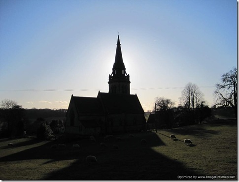
IMG_0486 The fifth cache of the day was easily found and I managed to log our visit on the scroll of paper in between other people passing (of which there were lots at this cross-roads of little lanes).

Back on the estate, the next box was secreted behind a tree, within two feet of where we pass almost on a weekly basis. This was where we needed to deviate from our route a bit, and with the options of taking an out-and-back route via Rights of Way or indulging in a bit of trespass, we opted to trespass.

That led us to the seventh and eighth of the day, and to the conclusion that seeking out plastic tubs did give an unexpectedly pleasing objective to the walk.

With just one cache left to find we suddenly found ourselves in the midst of a hundred dog walkers (always seems to be the case in this location about an hour before sun-down), but we soon shook them off as we headed into one of the juvenile National Forest plantations. Unfortunately, inside of the plantation turned out not to be where we needed to be; we needed to be just the other side of the far boundary, which left us bashing through the undergrowth trying to find a way back out of the enclosure.

We couldn’t sign the log of the last one, as it was a container so tiny that it didn’t contain a writing implement (and we hadn’t got a pen or pencil between us), but we were happy to have found it.

We opted to take the short route home from there, rather than the intended long route (it gave us the opportunity to have a look at progress on an oak-framed house in the village that has been under construction for a long time).

The stats for the day were 6.5 miles walked, with 450 feet of ascent (steady on there!), and eight out of nine geocaches found.


Thursday, 28 January 2010

Broken!

I spent the last two days tackling the overgrown, ivy-riddled mass that is the 70 feet long by 12 feet high hawthorn hedgerow that runs along one side of our garden. That involved a lot of climbing up and down a ladder (probably totalling more ascent than we achieve in any of our local walks) and exercised muscles in my upper body which have long been lying dormant.

Ignoring the aches and pains of this unaccustomed exercise and ignoring the tiredness caused by two days of constant physical exercise (three days if you count Monday’s walking), it seemed like a good idea today to go out for another stroll. Erroneously, it also seemed like a good idea to take that stroll whilst wearing a weighted backpack.

I completed the 14.25 miles (yes, the same route as Monday) in a state that I would describe as ‘hurting’ (Mick would probably describe it more as ‘whinging’). Call me a girly-wuss, but every movement aches.

And there’s still two-thirds of the woefully-neglected hedge left to cut in between more training walks…

Wednesday, 27 January 2010

Last Monday’s Leg-Stretch

“This isn’t where the path should be” I said to Mick, poring over the 1:25k map, which I had thought would assist us as we passed over farmland that we have not before trodden.

For the second incident of ‘the path’s moved’, we were in the vicinity of the recently four-tracked west-coast mainline and it didn’t take a great deal of thought to conclude that:

1) the expansion of the railway had caused some footpaths to be rerouted (to avoid having two footbridges within a few hundred yards of each other); and

2) we had probably owned the map in question since we first moved to the area eight years ago, and thus it was quite likely that it was out of date.

Happily, a few way-marks and a bit of guessing* as to what had been done with the paths saw us back on land that matched the map.

Even more happily, although mud was still a major feature, it stayed nearly dry for nearly all of the outing.

The route was declared a success too. Much nicer than last Friday’s, taking in sections of a couple of canals as well as some well-kept farmland, with only a few paces of tarmac in the whole 14.25 miles. As for ascent, well, it was almost overwhelming in its absence at <350 feet.

 Blurry action shot as I sample a swing made out of rope and a skate-boardIMG_0472

The three spires of Lichfield Cathedral IMG_0474

Inquisitive little horse that was happy to follow us, but lost his nerve every time we turned aroundIMG_0475

(*It wasn’t until we got home that I discovered that the single-page print out of the 1:50k map, which we also had with us was up to date; it would have saved a bit of head-scratching if we had looked at it earlier.)

Sunday, 24 January 2010

The First Seven Days of Leisuredom

Between Saturday 16 January (the day after ceasing to be employed) and Friday 22 January, we walked on six out of seven days and covered 55 miles*. Hardly an earth-shattering number, but I was rather pleased with it (even if my legs are still undecided as to whether to forgive me for the sudden shock).

That pleasing statistic set me to thinking about how many (or rather, how few) miles per week I’ve been motivated to get out and cover over the last four months. Here’s the answer:

image

We will be setting out from Kent in just under 2 months time, and to make sure that I’m in a fit state to enjoy the walk, I’ll be aiming for the mileages for the next eight weeks to look nearer to the ‘Week 13’ column rather than like the ‘Week 1’ column.

(*We’ll gloss over the fact that this week’s 55 miles involved less ascent than we would often cover in a single day in a hillier place)

Squelch, Squelch, Squelch

It was with the added impediment of backpacks (mine filled mainly with towels and water, just to give a representative weight) that we set out from a nearby village, in the rain, on Friday morning. The route was a new one, albeit the majority of it we had followed before as parts of various other routes.

Rain became the prominent feature of the day. It varied from pouring to drizzle (more the former than the latter), although for a whole ten minutes near the end it did stop completely. Of course, we could have chosen to walk on another (drier) day instead, but neither of us had glanced at a weather forecast so we set out in blissful ignorance that there would be barely any let up all day.

With no shelter to be had, we ignored the rumblings of the tummies as lunchtime came and went, instead focussing on the fact that when we reached the canal we would find a bridge under which we could sit. And, of course, once we did reach that bridge and sit down for fifteen minutes we cooled down rapidly, which made for a speedy late-lunch.

It was last-half-mile-syndrome-a-go-go by the time we squelched back at the car (my right Salomon Elios hasn’t magically regained its waterproof qualities and Mick managed to pour quite a quantity of water into his boots too), some five hours after we had left, having covered just shy of 13 (often muddy) miles. Rather a change of pace from our 9.5 miles in 2.5 hours on the two previous days (a change in pace attributed to the packs, the underfoot conditions and the need for a bit of navigation).

The verdict on the route was that it won’t be added to our collection of regularly used training routes. Although not truly offensive, it does contain some not-nice farms (the sort that are more dumping grounds than pleasant farmland), plus a short section of a nasty road. I’ve gone back to the drawing board to try to find something else that’s reasonably local, less muddy and more pleasant. Tomorrow we might just go and sample that something else.

IMG_0469 Mick looking like a vagrant, sheltering under a characterless bridge for lunch

IMG_0467

(22 Jan 2010)

Although muddy, the flooding has diminished since last weekend. We’ve only walked the path on the above photo once before (on 4 March 2007), and this week it was much drier than on that occasion (see below)

P3040008a

(4 March 2007)

Thursday, 21 January 2010

27th Night

“They’ve still got their Christmas Tree up!” exclaimed Mick as we walked past towards the village yesterday afternoon.

“No!” I succinctly exclaimed in response.

Egged on by Mick we performed an about turn and nonchalantly passed the window in question twice more to verify this fact. I felt sure that if anyone was in that living room they would have no doubt what had made us walk past and look in three times in fifteen seconds, but what we had firmly established was that not only was there a Christmas tree, but it was all lit up.

It was curious that we were walking towards the village at all, given that we were under a mile from the end of our 7-mile canal circuit, and that home lay in the opposite direction. However, a few moments earlier, as we reached the junction where we would have turned left to go home, I had decided that a slightly longer route over the fields would be more pleasing, and that involved walking a few yards down the road first.

My plan had been to take the short route across the fields. Mick assumed that I meant the longer route and as he was slightly ahead of me, the longer route is the one we took.

It was fully dark by the time we reached the final field, which demonstrated that 2.30pm is not the best time of day to set out on a 9.5 mile walk if you want to be home before nightfall (although, in my defence, we had only set out on a 7 mile walk).

I couldn’t quite believe, upon arriving home, that we had completed the 9.5 miles in 2.5 hours, so we popped back out this afternoon to repeat the route (setting out an hour earlier, so we did make it home in daylight today). It took us five minutes longer today, although that’s probably because we stopped to chat to some little cows and some dwarf sheep.

Random picture of the little cows

(obviously not taken today; the snow has been gone for a while now)

IMG_0432


Index of LEJOG Posts

With our K2CW walk rushing towards us, it’s time to tidy up the Blog and make it less LEJOG-centred, whilst also making it easier for people who arrive here having Googled “LEJOG Walk” to find the LEJOG related stuff. So, set out below (so that they’re all in one place) are links to my LEJOG-related posts.

For those stumbling across this Blog for the first time, here’s a very brief intro:

On 15 April 2008, after a year of planning, my husband (Mick) and I set out from Land’s End to walk a 1252-mile route to John O’Groats. A bit of honing of the route saw the final distance reduce to 1240 miles, and we arrived in JOG exactly 12 weeks after setting out, on 7 July. During the walk I posted daily reports to the Blog, which can be found as a single document in the first link below. 

The entire LEJOG-blog in pdf format

LEJOG Route/Itinerary (Actual)

Cost of the LEJOG Trip

LEJOG Kit Review Part 1

LEJOG Kit Review Part 2

Final Pack Weight

Average Distances

The LEJOG Awards

LEJOG Reflections: Route and Bouncy Shoes

Just for Fun: The LEJOG Songs

Pocketmail as a Mobile Blogging Device

Packing List for Gayle (note: this was the first-draft packing list, it did get modified)

More Kit List Considerations

Packing List for Mick

Dehydrated Meals

Hair Today…

…Gone Tomorrow

Shoes for LEJOG (Part 1)

Shoes for LEJOG (Part 2)

Shoes for LEJOG (Part 3)

7-days-till-departure Random Thoughts

8-days-till-departure Random Thoughts

13-days-till-departure Preparation Report

36-days-till-departure Preparation Report

51-days-till-departure Preparation Report

66-days-till-departure Preparation Report

76-days-till-departure Preparation Report

LEJOG: The Big Picture

LEJOG Planning (Part 2.1)

LEJOG Planning (Part 2.2)

LEJOG Planning: From Falkirk North

LEJOG: Why?

Tuesday, 19 January 2010

A Jeff, Two Jays and a Woodpecker

Although our route on the Chase yesterday was the same on that we usually walk, there were some differences.

The first one was that we were starting from a different car park, on another side of the Chase, and having not visited that parking area before (other than on foot, from the Chase side) we had to pay attention to make sure that we spotted it from the road.

Then there was Jeff, who was joining us on this walk, and who, with perfect timing, pulled into the car park just a few moments after us.

Soon there was much chatting as we set out on our way under fair skies.

We had not gone far when I cut off mid-sentence upon hearing a screeching cry, and it didn’t take me more than a second or two to locate the source: two jays flitting between the nearby trees. We’ve only seen jays over there once before, and it was a treat on this occasion to see them at such close range.

Visibility was good (not fantastic, but not too shoddy), so views were to be had once we had gained the high-point of the route, having climbed up the valley from Stepping Stones (where there was not a single other person, disproving my previous statements that there are always people at the Stepping Stones – in fact the whole of the Chase was abnormally quiet, even for a Monday morning).

The deer must have been hungry after the recent bad weather as the grazing group of fallow deer (some with huge antlers) that we came across barely paid us any heed as we stopped to admire them. Later (after we had enjoyed cups of tea in a cafe we have walked past almost weekly, but which we have never before visited), another herd was spotted a short distance away from us in the forest and again they watched us, but didn’t absent themselves. It’s highly unusual to see any deer in daylight over there, never mind openly grazing in spite of on-lookers.

Everything was uneventful as we chatted our way through our usual car park, through the abandoned quarry, past the abandoned rifle range, through some forestry, then some woodland, to come back out at our starting point.

Taking advantage of one of the picnic tables there, cups of tea were drunk (and the more organised amongst us (i.e. Jeff) had lunch). I picked the right side of the table, as it gave an excellent view of the three bird feeders that some kind person had hung from a nearby tree. I didn’t pay much attention to most of the species visiting those feeders, but my attention was certainly captured by the great spotted woodpecker as it clung onto the wire and saw off all of the smaller birds that tried to land on what had obviously become his property.

I was well and truly kicking myself for having forgotten to take the camera (which also explains the big, photoless block of text above), and it wasn’t until the woodpecker’s second visit that I thought to ask Jeff if I could borrow his camera. Alas the inevitable happened, and as soon as he reached into his pack the woodpecker mutttered ‘Photograph me? Not on your nellie!’ whereupon he flitted off into the woodland, not to be seen again (mainly because that was the point at which we all left).

Being our usual route it was, unsurprisingly, still 8 miles long and still featured 1000 feet of up.

K2CW: Train Tickets Bought

Gulp! This K2CW jaunt is getting close, isn’t it?

I’ve bought our train tickets to get us down to St. Margaret’s at Cliffe (actually, the train will get us to Martin Mills, we’ll walk the rest).

£14.50 each from Lichfield. Bargain!

Sunday, 17 January 2010

Oh, and by the way…

…as of Friday just gone, I am unemployed (which, for the avoidance of doubt, is a Good Thing – as you may have noticed we have a big walk coming up and that’s not really compatible with sitting in an office for half of each week).

So I’m rather hoping that things will start getting a little bit more interesting around here than the recent repetitions of “we walked around the block” and “we walked along the canal”.

This Sunday

After yesterday’s mud-fest I did look at a map and come up with a reduced-mud route for today.

Leaving the house we then completely ignored the revised route and set out in the same direction as we usually would.

Fortunately, it had been a bit nippy overnight and so some of the ground was sufficiently frozen to minimise the mud. Most ground was still soft, and very wet indeed.

It was in giggles at our comedy-sized feet that we crossed the first crop field. The ground had taken on the exact clay-like consistency that made what felt like tons of the stuff cling to our shoes within the first three steps. So heavy had my feet suddenly become that I had my doubts that I would still be able to lift them when we got to half way, and I was feeling the effort when we reached the far side (not good with 1 mile down and 10 to go!).

IMG_0448 Mud clings to Mick’s feet as we clear the first of the crop-fields

As we only tend to walk the first bit of this route between January and April (that being the time of year when we always seem to be in training for something), we’ve not been this way for a while, and as usual there were changes. Last year I noted that stiles had been repaired and gaps had been put in electric fences when they crossed ROWs. This year the gaps have gone. I went for the limbo technique; Mick went for stepping over (which seems a dangerous strategy to me!).

Some miles later (back onto a bit of the route that I’ve walked a few times recently) we came upon a remarkably unusual sight:

IMG_0449“Are they allowed to be here, on our path?” I asked Mick. Save for the very occasional dog-walker, we don’t see people on this part of the route, so an entire gaggle of ramblers was unexpected.

They were a jolly bunch, who, as we passed them, engaged us on the subject of whether there really are big cats out there in the wild.

The most bizarre occurrence of the walk, however, was the presence of a Dalmatian being walked along a nearby track just as we broke out of some woodland. Not a strange occurrence in and of itself, but the last twice I walked out of this woodland that dog was in the exact same place in its walk. The only difference today was that it was on a lead, so it didn’t run, full-pelt across the field towards me.

Even having acknowledged the general waterloggedness of the ground, it wasn’t until we dropped down from the golf-course (no-one playing today), towards the river, that it struck me that our route may not be passable. From this vantage point we could see that river had flooded, and that didn’t bode well for our passage a mile or so hence.

A particular water obstacle had confounded a few people who were wandering around trying to find away to avoid it. We also looked briefly for a way around before acknowledging that we had two choices: turn around and walk back the way we had come, or walk on through.

I went for the socks-off approach, whilst Mick just splashed through. An older couple watched with interest from a distance, but still reluctant to follow our lead, they went to investigate an option that we had already explored and discounted.

IMG_0450

Emptying the water out

IMG_0451 Back on with the socks (as it went the shoes were holding so much water that a while later I had to take the socks back off to wring them out)

The water certainly was high when we got to the river section (where the river and the canal share their course for a short distance):

IMG_0455And the adjacent fields a little further along were doing good impressions of lakes:

IMG_0457 It wasn’t like that seven days ago!

The river section was closed today. Even though the indicator on the lock was on amber, meaning ‘proceed with caution’, the lock gates were padlocked shut. I’m sure that, if I had looked at the status board a little later it would have read ‘closed’, but I didn’t even give it a glance.

IMG_0458River-state indicator on Amber

IMG_0459

Gates wired together and padlocked shut

By the time we got to the local ponds, my body was complaining. This was the furthest that I’ve walked in one day since 21 August last year, and somehow we failed to have a break at any point (unless you count sitting on a wall a quarter of a mile before the ponds to wring my socks out).

As for the ponds, there was still a layer of ice, but not so much as to entice anyone but the most fool-hardy to test it for weight-bearing strength.

Four hours after setting out, with 11.25 miles covered, we arrived home once again liberally covered in mud. Not wanting to look like a vagrant when we meet Jeff on the Chase tomorrow, the Paramo has all taken a swim in the washing machine tonight. I’m sure that the cleanliness will last all of ten minutes!

Saturday

Hearing the rain hammering against the windows as I woke up yesterday morning, adding itself to the heavy rain of Friday morning, and further adding itself to the snow-melt, my first thought was that all of the local fields would be a mud-fest and that I would find a tarmac-only route for a quick, local walk.

At 3.30pm, we were rapidly running out of daylight and I had failed to even glance at a map. Out came my new gaiters (my only gaiters, actually; I’m not a gaiter fan) in an effort of saving my trousers from another dose of mud, and off we set on our usual “shuffle around the block” route.

I wasn’t wrong about the mud, and the gaiters didn’t save the trousers. So much mud was being kicked up by our boots that not only were the trousers liberally spattered, but my jacket didn’t escape either (and my mittens ended in a disgusting state). When an over-excited dog came tearing across the field at us and (in spite of my pleas not to jump up me) jumped up me, the muddy paw-prints were barely noticeable amongst the spatter.

Returning home just as darkness was overtaking us, I resolved to find a mud-free route for today (Sunday).